Topics

    Not found Special Section on The India-Eurasia Collision and Its Long-Range Effect

    Wang Xiaolong

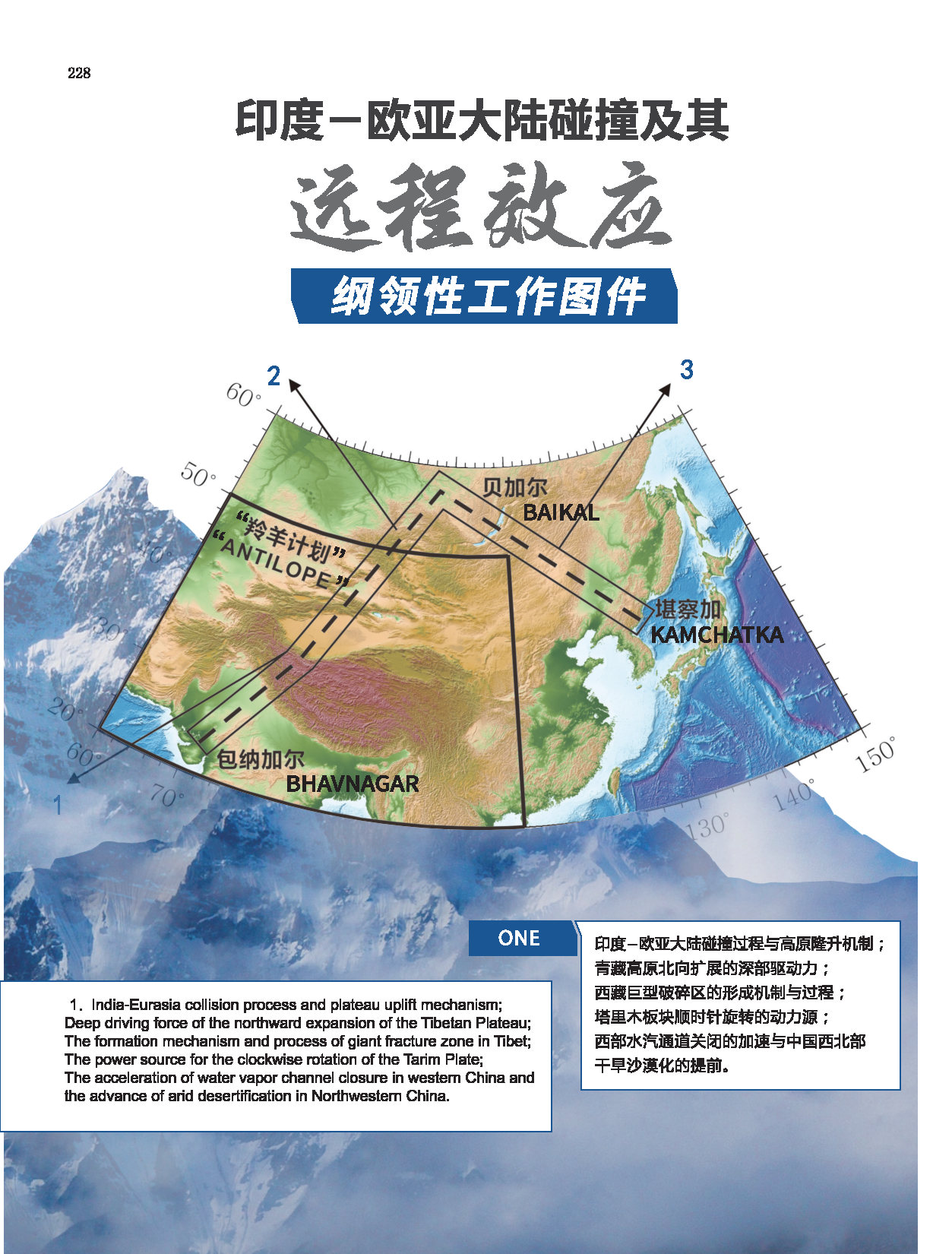
    The special issue of "India-Eurasia Continental Collision and Its Remote Effects" in the Earth Science Frontiers gathers important papers on the lithospheric structure, geological structure, and geodynamic processes of the Tibetan Plateau and its surrounding areas. These articles explore the impacts of the collision between the Indian and Eurasian continents and the uplift of the Tibetan Plateau on the formation and evolution of the Earth's geodynamic system.

    This special issue covers in-depth research on the deep exploration and lithospheric structure of the Tibetan Plateau, revealing the structure of the crust and upper mantle, and delving into the mechanisms of plateau uplift. The studies primarily focus on the geological structure and evolution of the Tibetan Plateau, providing profound insights into the deep crustal structures and geodynamic processes in different regions or tectonic zones. Furthermore, the research highlights the driving mechanism for the northward drift of the Indian Plate and the effects of continental collision and plateau uplift on the Baikal region. Additionally, the special issue includes technical innovations conducted in the Tibetan Plateau, such as distributed acoustic sensing for shallow exploration, presenting new research approaches for a deeper understanding of the geodynamic processes in the Tibetan Plateau.

     Overall, this special issue emphasizes the geological evolution and tectonic processes of the Tibetan Plateau, providing essential theoretical foundations for environmental resources and geological evolution studies. Its publication will promote interdisciplinary development and collaboration in Tibetan Plateau research and offer new insights for the advancement of global geoscience.

    Default Latest Most Read
    Please wait a minute...
    For Selected: Toggle Thumbnails
    Overview of the crustal and upper-mantle structures of the Mongolian Plateau
    YANG Wencai, CHEN Zhaoxi, SHI Zhanjie
    Earth Science Frontiers    2023, 30 (4): 218-228.   DOI: 10.13745/j.esf.sf.2023.4.30
    Abstract163)   HTML16)    PDF(pc) (15550KB)(219)       Save

    Geophysical survey and comprehensive geological analysis show that the crustal structure of the Mongolian Plateau is mainly formed under the effects of terrane amalgamation and closures of the Paleo-Asian and Mongolia-Okhotsk Oceans. Among them, the closure of the Paleo-Asian Ocean affected mainly the west and south of the Mongolian Plateau, causing the crustal uplift in the Altai collisional orogenic belt and the subsidence of the Ubuds-Bayanhonggol crust, and affecting the secondary uplift of the Hangai Mountain massif. In the east of the Mongolian Plateau, there was no strong collision at the closing of the ancient Mongolia-Okhotski Ocean in the Mesozoic Era, and the upper and lower Amur massifs and the Xilinhot land block completely merged together into one land block. This type of terrane amalgamation indicated slow land-to-land subduction played a major role. Of course, slow land-land subduction might also cause numerous crustal deformation and magma intrusions leading to continental accretion. The closure of the Mongolian-Okhotsk Ocean did not result in obvious shortening and thickening of the Earth’s crust, but large-scale mantle source magma intrusions occurred, which caused the crust to melt and the crystalline bedrock to cratonize rapidly. In the upper mantle beneath Mongolia, there are residual traces of a plume reflecting the thermal fluid upwelling to the uppermost mantle.

    Table and Figures | Reference | Related Articles | Metrics | Comments0
    Aeolian deposits in the Yarlung Zangbo River basin, southern Tibetan Plateau: Spatial distribution, depositional model and environmental impact
    XIA Dunsheng, YANG Junhuai, WANG Shuyuan, LIU Xin, CHEN Zixuan, ZHAO Lai, NIU Xiaoyi, JIN Ming, GAO Fuyuan, LING Zhiyong, WANG Fei, LI Zaijun, WANG Xin, JIA Jia, YANG Shengli
    Earth Science Frontiers    2023, 30 (4): 229-244.   DOI: 10.13745/j.esf.sf.2022.9.7
    Abstract254)   HTML12)    PDF(pc) (8436KB)(570)       Save

    Situated in the suture zone formed by the India-Euroasia collision, the Yarlung Zangbo River (YZR) basin in the southern Tibetan Plateau is a hotspot for Earth systems research, where Middle-Pleistocene aeolian deposits not only provide an important window into the history of climate change and atmospheric circulation in the Tibetan Plateau, but also help us to gain a deeper understanding of the link between tectonics, climate and landscapes in general. However, a systematic understanding of the distribution, depositional model, and environmental effects of aeolian sediments in this region is still lacking. Here, we construct a new atlas and a depositional model of aeolian sediments in the YZR basin based on extensive field investigation as well as laboratory analyses of typical sediment samples collected across the region, combined with existing research results. In general, aeolian sand and loess are distributed in patches and usually occur together. A close provenance relation between loess and nearby loose sediments such as sand dunes and river sands indicates that aeolian sediments cycle locally, hence they record spatial changes of regional climate; in contrast, the valley sediments not only receive dust from distant sources but also contribute dust materials to the world via upper-level westerly winds. Middle-Pleistocene aeolian dust activity in the YZR basin was controlled combinedly by tectonic movement and global climate change; whereas aeolian dust activity during the Holocene was relatively complex under the river valley environment, and regional climate change was generally influenced by the synergistic effect of the mid-latitude Westerlies and the Indian summer monsoon.

    Table and Figures | Reference | Related Articles | Metrics | Comments0
    Sedimentary environment, provenance analysis and tectonic significance of the Upper-Cretaceous Abushan Formation in 114 Daoban, Anduo area, Qiangtang Basin
    DU Lintao, BI Wenjun, LI Yalin, ZHANG Jiawei, ZHANG Shaowen, YIN Xuwei, WANG Chengxiu
    Earth Science Frontiers    2023, 30 (4): 245-259.   DOI: 10.13745/j.esf.sf.2023.6.1
    Abstract91)   HTML5)    PDF(pc) (6498KB)(115)       Save

    Late-Cretaceous continental strata of the Abushan Formation consist mainly of coarse clastic rocks and outcrop widely in the Qiangtang Basin, however, its sedimentary environment, source characteristics and tectonic setting remain unclear. In order to better understand the sedimentary evolution of the Qiangtang Basin and the early Tibetan Plateau uplift history after the Qiangtang-Lhasa collision we conducted detailed investigation into the depositional age, sedimentary environment, and source characteristics of the Abushan Formation in 114 Daoban, Anduo area. Angular unconformities were observed between the Abushan Formation and the underlying andesite and overlying Niubao Formation. Based on this observation, along with the eruption age of andesite and the depositional age of the Niubao Formation, we conclude that the Abushan Formation was deposited during the Late Cretaceous. Gravels of the Abushan Formation indicated a near-source deposition scenario as they mainly consisted of limestone and were transported over a short distance. Combined with geochemical data on sandstone detritus and heavy minerals, along with detrital zircon age spectra, we consider that the Abushan Formation was mainly sourced from Triassic-Jurassic strata in the southern Qiangtang and the central uplift zone. By comparing the stratigraphic characteristics between the Abushan Formation and its surrounding area, we suggest that the deposition of continental red clastic rock during the Late Cretaceous was related to large-scale thrusting in the Qiangtang Basin caused by continued plate convergence in the Qiangtang-Lhasa terranes.

    Table and Figures | Reference | Related Articles | Metrics | Comments0
    Electron spin resonance dating for the Central Churia Thrust of the Nepal Himalaya
    NEUPANE Bhupati, ZHAO Junmeng, LIU Chunru, PEI Shunping, MAHARJAN Bishal, DHAKAL Sanjev
    Earth Science Frontiers    2023, 30 (4): 260-269.   DOI: 10.13745/j.esf.sf.2023.4.1
    Abstract162)   HTML5)    PDF(pc) (5201KB)(94)       Save

    A temporal pattern of Quaternary fault activity of the Central Churia Thrust (CCT) in the southern Nepal Himalaya has been investigated using Electron Spin Resonance (ESR) signals of quartz grains in fault gouge samples. In order to better understand the reset process, the study of the variations in ESR signal, accumulated dose, and age in various quartz grain sizes was analysed. The results of the E1’ center (a type of signal for ESR dating) of sample CCT3 show a significant spatial variation in the bulk, coarse (200-250 μm), and fine (40-80 μm) grain-size fractions. The ESR date of Quaternary faults, coarser age of (5±0.5) ka and finer fraction mean age of (50±10) ka, demonstrates the latest extension event in the Siwalik region.

    Table and Figures | Reference | Related Articles | Metrics | Comments0
    Receiving function imaging reveals the crustal structure of the East Kunlun fault zone and surrounding areas
    TONG Xiaofei, XU Xiao, GUO Xiaoyu, LI Chunsen, XIANG Bo, YU Jiahao, LUO Xucong, YUAN Zizhao, LIN Yanqi, SHI Hongcheng
    Earth Science Frontiers    2023, 30 (4): 270-282.   DOI: 10.13745/j.esf.sf.2023.4.20
    Abstract119)   HTML5)    PDF(pc) (7029KB)(119)       Save

    Previous studies have suggested that the Tibetan Plateau continues to undergo eastward extrusion since the Miocene, and the observed sinistral strike-slip deformation in eastern Kunlun is strong evidence of such movement. To gain a better understanding of the land deformation, stress transfer, and material transport on the Tibetan Plateau, it is crucial to correctly identify the location of faults and the regional crustal structure. Geodetic and geomorphic evidence have indicated an eastward decrease of slip rate along the eastern Kunlun fault, particularly in the Roergai Basin covered with a variety of Quaternary sediments. However, due to basin’s alpine herbaceous swamp nature, it is particularly challenging to identify fault traces in the basin; as a result, the location of the eastern Kunlun fault within the Roergai Basin is unclear. In this contribution, a dense array of 167 seismic stations (spaced at ~1-km intervals) and 9 broadband stations were used to investigate the crustal structure beneath the eastern Kunlun fault in the Ruoergai Basin. Through basin-wide comparisons of discontinuities in crustal strata and Moho depth variations it was determined that the eastern Kunlun fault continues to extend eastward through the Ruoergai Basin; in addition, an inheritance relationship between the Tazang and eastern Kunlun faults was identified based on crustal structure similarities. The results of this study provide high-resolution evidence for the outward expansion of the Tibetan Plateau.

    Table and Figures | Reference | Related Articles | Metrics | Comments0
    Deep crustal structure of the southeastern Lhasa Terrane
    XU Xiao, YU Jiahao, XIANG Bo, GUO Xiaoyu, LI Chunsen, LUO Xucong, TONG Xiaofei, YUAN Zizhao, LIN Yanqi, SHI Hongcheng
    Earth Science Frontiers    2023, 30 (3): 221-232.   DOI: 10.13745/j.esf.sf.2023.2.10
    Abstract169)   HTML11)    PDF(pc) (13497KB)(173)       Save

    The southern Lhasa Terrane is the foremost area to investigate plate boundary interactions in the India-Eurasia collision zone. Prior to Cenozoic continental collision, the southeastern Lhasa Terrane underwent multi-stage tectonic evolution under Mesozoic subduction of the Tethyan oceanic lithosphere, which resulted in a complex regional crustal structure that renders inconsistent observations of its deep structure using different geophysical methods with different resolving power. Presently, broadband seismic observation and deep seismic reflection data disagree on the location of the subduction front at the Indian plate. To gain further insight, a short-period dense array survey line was laid parallel to the previous survey line. By using high-resolution P-wave receiver functions, we discovered that the previously defined northward extension of the Indian lower crust based on broadband data is actually not continuous. In fact, the Indian crust exists only beneath the Yarlung Zangbo suture zone, which is consistent with deep seismic reflection results. The middle and upper crust of the Lhasa Terrane develops a thrust fault under south-north compression, while lower crustal eclogitization observed in the broadband seismic data is mainly located in the north of the Yarlung Zangbo suture zone in the middle Lhasa Terrane and southern part of the North Lhasa Terrane.

    Table and Figures | Reference | Related Articles | Metrics | Comments0
    Attributes and evolution of the eastern massif in the Qinghai-Tibetan Plateau
    LIU Xiaoyu, YANG Wencai, CHEN Zhaoxi, QU Chen, YU Changqing
    Earth Science Frontiers    2023, 30 (3): 233-241.   DOI: 10.13745/j.esf.sf.2023.2.5
    Abstract207)   HTML3)    PDF(pc) (12127KB)(223)       Save

    Using high-quality seismic data collected from a large number of local seismic stations, we have achieved high-resolution imaging of the three-dimensional velocity structure of the crust and upper mantle in the Qinghai-Tibetan Plateau with an accuracy of 0.5°×0.5°×10 km, which revealed in great detail the crustal and upper mantle structure of the Qinghai-Tibetan Plateau and provided new evidence for understanding the dynamics of continental collision and plateau evolution. Then, based on the 3D seismic P-wave velocity data, a 3D depth map of the lithosphere-asthenosphere boundary beneath the Qinghai-Tibetan Plateau is obtained. It is found that there are fundamental differences in geological attributes between the eastern and western parts of the plateau: The eastern part is dominated by thick lithosphere with high wave velocity, high resistivity and density, and a thickness range of 150-180 km; whereas the west is dominated by thin lithosphere with low wave velocity, low resistivity and density, and thickness ranging between 130-155 km. Furthermore, there is no large-scale asthenospheric upwelling in the eastern part whereas ~20-30 km upwelling has occurred in the west. The coordinates of the two endpoints of the east-west boundary are (20°N, 85°E) and (40°N, 98°E) respectively. According to the paleomagnetic data, the eastern massif in the Qinghai-Tibetan Plateau is a stress transition zone situated between the western continent-continent subduction zone and Southeast Asia ocean-continent subduction zone since 40 Ma.

    Table and Figures | Reference | Related Articles | Metrics | Comments0
    Structure, composition and evolution of the Indosinian South Qiantang accretionary complex
    WANG Genhou, LI Dian, LIANG Xiao
    Earth Science Frontiers    2023, 30 (3): 242-261.   DOI: 10.13745/j.esf.sf.2023.1.12
    Abstract145)   HTML6)    PDF(pc) (12232KB)(192)       Save

    Orogenic belts can be divided into three types: accretionary, collisional and intraplate-type. Accretionary orogenic belts are of great significance for understanding the subduction and closure history of the ancient oceanic basin, as they can preserve the most geological information during oceanic subduction. Whereas to clarify the tectonic significance of accretionary orogens, it is critical to identify the basic units of the ancient subduction zone, which include trenches, accretionary complexes, forearc basins, magmatic arcs, and back-arc basins, where information on the accretionary complexes, the main product of oceanic subduction, such as their composition and structure as well as their recorded structural deformation and metamorphic history, can directly reveal the dynamic evolutionary process and accretionary orogenesis during plate convergence. The South Qiangtang accretionary complex is a recently identified geological unit of central Tibet. It has the potential to answer such scientific questions as the formation and evolution of the Paleo-Tethys Ocean and the origin of the Central Qiangtang uplift, which is of importance for resource and energy exploration. However, there are many unknowns about the South Qiangtang accretionary complex, including its tectonic attribute, dynamic process, subduction zone structure, and deep geological process. In this paper, we aim to clarify the composition, structure, and geological evolution of the South Qiangtang accretionary complex through detailed studies on the ancient-subduction-zone identification, composition and structure of accretionary complexes, and exhumation mechanism of high-pressure metamorphic rocks, in order to provide a theoretical basis for understanding the regional metallogenic evolution and carbon mineralization pathway and guiding resources prospecting. In the central Qiangtang, we identified a relatively complete trench-arc-basin system consisting of continental margin arc, fore-arc basin, trench slope basin, and high-pressure metamorphic rock-bearing accretionary complex, evidencing an ancient subduction zone. On the plane, the South Qiangtang accretionary orogenic belt presents “mylonitic structures” at different scales, reflecting the extensive and strong ductile shear rheology during plate subduction; vertically, it exhibits an obvious double-layer structure, where the upper layer is a fold-thrust belt formed from deformation of the South Qiangtang terrane, while the lower layer comprises multi-stage deformations, reflecting the important role of subduction-at-continental-margin in the orogenic process. In addition, differential metamorphic evolution of high-pressure metamorphic rocks is obvious across the orogenic belt, and the exhumation mechanism is complex and diverse, reflecting the complex deep process of the subduction zone. Therefore, according to our research and previous data, the South Qiangtang accretionary orogenic belt is the product of Permian-Early Triassic subduction and accretion of the Longmu Co-Shuanghu Paleo-Tethys Ocean that expanded during the Late Devonian-Early Carboniferous period, and formed in the Middle-Late Triassic during the collision of the North and South Qiangtang terranes.

    Table and Figures | Reference | Related Articles | Metrics | Comments0
    Tectonic evolution and Cenozoic deformation history of the Qilian orogen
    WU Chen, CHEN Xuanhua, DING Lin
    Earth Science Frontiers    2023, 30 (3): 262-281.   DOI: 10.13745/j.esf.sf.2022.12.20
    Abstract638)   HTML41)    PDF(pc) (14534KB)(568)       Save

    The Qilian orogen—formed along the northern margin of the eastern Tethys as results of pre-Cenozoic multi-phase subduction, continental collision and punctuated orogeny involving the North China craton and the Qaidam paleocontinent—develops widespread ophiolitic mélange belts and (ultra-) high pressure metamorphic and arc igneous rocks. The present Qilian Mountains, a key tectonic zone undergoing plateau uplift/expansion along the northern margin of the Tibetan Plateau, with complex intracontinental deformation and deep structures, records the histories of tectonic deformation and basin-mountain evolution during different stages of plateau growth in the Cenozoic. This paper, on the basis of comprehensive analysis of regional geological data, discusses the nature of Proterozoic metamorphic basement, paleo-oceanic evolution during the Neoproterozoic-Paleozoic, and Mesozoic-Cenozoic structural deformation, and explores the tectonic evolution of the Qilian orogen and the intracontinental deformation history of the Qilian Mountains. The Early-Neoproterozoic and Early-Paleozoic arcs represent respectively subduction-collision events took place in the Paleo-Qilian and (South/North) Qilian oceans. Basement structure beneath the North China craton suggests that the Qilian ocean is not the ocean separating the Gondwana and Laurasia continents, but rather a relatively small embayed sea along the southern margin of the Laurasia continent. The northeastern margin of the Tibetan Plateau experienced two-stage tectonic deformation and basin-mountain evolution in the Cenozoic, while transition from Early-Cenozoic thrust activity to joint action of strike-slip/thrust faults occurred in the Miocene, where, with rapid uplift of the Eastern Kunlun Range, a large Paleogene basin split into two basins—the current Qaidam Basin and the Hoh Xil Basin. Since the Middle-Late Miocene the tectonic framework along the margin has been mainly controlled by the development and clockwise rotation/lateral growth of two large near-parallel transpressional tectonic systems, of Eastern Kunlun and Haiyuan. The growth process and development mechanism of the large-scale strike-slip fault system in the Qilian orogen is a central issue of research on intracontinental deformation and requires in-depth quantitative examination.

    Table and Figures | Reference | Related Articles | Metrics | Comments0
    Genesis of the Baikal Rift and the Fenwei Graben and the remote effects of the Indo-Eurasian collision
    LIANG Guanghe
    Earth Science Frontiers    2023, 30 (3): 282-293.   DOI: 10.13745/j.esf.sf.2023.1.30
    Abstract208)   HTML37)    PDF(pc) (14938KB)(352)       Save

    The Baikal Rift and the Fenwei Graben are two famous rift systems located in the eastern Eurasian plate, with similar topographic features and geomorphic characteristics. Their tectonic evolution histories are also similar. Many studies have shown that their formation is closely related to the Indo-Eurasian collision, however, the mechanism for this long-range effect is not clear. In this paper, basing on the evolution of extensional tectonics caused by mantle upwelling in the continental margin during the continental drift and continental margin splitting, combined with the Cenozoic tectonic evolution of Eurasia, we studied the evolution of microcontinental fragments and extensional tectonics under the long-range effect. The results show that the origin of the two rift systems is closely related to the Cenozoic large-scale fragmentation and drift of microcontinents in the eastern margin of the Eurasian. Briefly, the Qinghai-Tibet Plateau uplift results in large-scale mantle upwelling and continental breakup in the Cenozoic, where the breakup and drift of the proto-Japan/proto-Kamchatka blocks form a differential sinistral strike-slip environment, and lead to the formation of the two rift systems in two seismic zones on the southeast side of the Siberian and Ordos Basins. These two seismic zones, which have similar genetic mechanisms to the Türkiye earthquake in February 2023, are formed by strike slip faults, and their genetic mechanisms can be reasonably explained by the new continent drift model.

    Table and Figures | Reference | Related Articles | Metrics | Comments0
    Crustal-scale plate interactions beneath the dominant domain in the India-Eurasia collision zone—a tectonogeophysical study
    GUO Xiaoyu, LUO Xucong, GAO Rui, XU Xiao, LU Zhanwu, HUANG Xingfu, LI Wenhui, LI Chunsen
    Earth Science Frontiers    2023, 30 (2): 1-17.   DOI: 10.13745/j.esf.sf.2022.11.7
    Abstract477)   HTML168)    PDF(pc) (11297KB)(524)       Save

    Since the Early-Cenozoic onset of the Indian plate subduction beneath the Eurasian plate along the Yarlung-Zangbo suture zone (YZSZ), the subduction process has gained wide interests among geologists. However, crustal-scale vertical interactions between the two plates beneath the dominant domain in the collision zone remains unclear owing partly to the lack of high-resolution datasets, which has severely limited the understanding of the crustal thickening mechanism of the dominant collision domain and its deep geodynamic processes. In this study, fine structural interpretation of two deep seismic reflection profiles—180 km and 100 km long cutting through the middle and eastern part of the YZSZ, respectively—revealed the crustal-scale lateral and vertical contact relationships between the subducting Indian plate and the overriding Lhasa terrane. (1) Laterally, the Indian lower crust subducts northward, with limited subduction front beneath the southern margin of the Lhasa terrane (SLT) which is shown as non-reflective crust, while the Central Lhasa terrane (CLT) is north-dipping. (2) Vertically, the Indian lower crust undergoes subduction, while crustal duplexing occurs in the middle-upper crust. Nearly three quarters of the SLT crust are non-reflective crust, while the rest, the SLT upper crust, is south-dipping. The CLT crust can be divided into two domains: north-dipping lower crust and concave-downward upper crust. Differential vertical zonation is observed in all three tectonic units. (3) The upper crust of the dominant collision domain has a consistent deformation pattern, where a sequence of break-backward imbricate structures is present. This break-backward imbricate system can be traced from the Luobadui-Mila fault of the northern edge of SLT, beyond YZSZ, to the northern edge of the North Himalaya dome belt. Combing with the previous findings based on coincident magnetotelluric data on the southward migration of high conductive barrier of SLT thrusting along the main Himalayan into the northern Himalayas, we believe the episodic magmatism in the Tethyan Domain beneath SLT generated juvenile crust that is prone to anomalous thickening. Meanwhile, during India-Eurasia plate interaction, mantle-sourced magmatism in SLT—generated from northward subduction of the Neo-Tethyan oceanic slab and subsequent collision between the India and Eurasia plates—caused southward thermal migration, which induced anatexis in the northern Himalayas and weakened the crustal strength of the region. The ongoing crustal-scale duplexing therefore leads to antiformal stacking and causes crustal thickening. Rapid exhumation of the North Himalayan dome by the increasing antiformal stacking, meanwhile, exerts sudden northward compression to the overlying Tethyan Himalayan sequence, which eventually creates fault-propagation folds following a break-backward sequence in the upper crust through the whole dominant collision domain. Overall, vertical and lateral tectonic interactions within the dominant collision domain in the India-Eurasia collision zone played an important role in producing such anomalous thick crust, but the break-backward imbricates system in the upper crust lowered topographic relief in the dominant collision domain as well.

    Table and Figures | Reference | Related Articles | Metrics | Comments0
    The uplift and exhumation processes in the Qiangtang terrane of Central Tibet since the Cretaceous
    BI Wenjun, ZHANG Jiawei, LI Yalin, DENG Yuzhen
    Earth Science Frontiers    2023, 30 (2): 18-34.   DOI: 10.13745/j.esf.sf.2022.11.50
    Abstract336)   HTML33)    PDF(pc) (7876KB)(329)       Save

    The Tibetan Plateau uplift resulted in regional and global climate changes; however, the geomorphic evolution of the Tibetan Plateau is still in dispute. As a significant part of the Tibetan Plateau, the Qiangtang terrane plays an important role in understanding the geomorphic evolution of Central Tibet. The published structural deformation and low-temperature thermochronological data showed that the uplift and exhumation of the Qiangtang terrane experienced three main phases: Early Cretaceous-Paleocene (120-65 Ma), Eocene (55-35 Ma), and Post-Oligocene (<30-0 Ma). During the Early Cretaceous-Paleocene, the Lhasa-Qiangtang collision and the tectonic load of the Central Qiangtang terrane led to outward-propagating deformation and exhumation originated from the Central Qiangtang terrane. During the Eocene, northward and southward subductions of the Lhasa and Songpan-Ganzi terranes, respectively, driven by continued convergence between the Indian and Asian plates, resulted in intensive deformation and exhumation of the Southern Qiangtang terrane and the northern edge of the North Qiangtang terrane, but little erosion and deformation in the Central Qiangtang terrane and central zone of the North Qiangtang terrane. The Qiangtang terrane had attained an elevation of 3-4 km by ~35 Ma. Since the Oligocene structural deformation in the Qiangtang terrane has ceased, where surface exhumation may be related to N-S trending normal fault activity in the region.

    Table and Figures | Reference | Related Articles | Metrics | Comments0
    Late-Triassic stratigraphic redefinition of and structural deformation in the Tethys Himalayan Belt in Gyaca area, Tibet
    TANG Yu, WANG Genhou, HAN Fanglin, LI Dian, LIANG Xiao, FENG Yipeng, ZHANG Li, WANG Zhuosheng, HAN Ning
    Earth Science Frontiers    2023, 30 (2): 35-56.   DOI: 10.13745/j.esf.sf.2022.8.55
    Abstract338)   HTML27)    PDF(pc) (31933KB)(252)       Save

    The Late-Triassic middle-low metamorphosed rock assemblage exposed in the Gyaca area of the northeastern Tethyan Himalaya, southern Tibet, including the Langjexue Group, had been regarded as a set of abyssal-bathyal flysch strata. This study reveals the Upper-Triassic strata are bounded by a steep shear zone (SSB) where obvious differences in composition, structural deformation and metamorphism between north and south are observed. The northern SSB is characterized by accretionary complex with a “matrix + blocks” structure, with little fossil preserved to reveal its primary sedimentary structure. The “blocks” are mainly composed of meta-sandstone, limestone, marble, green-schist, basaltic schist, metasdiabase, actinolite schist and garnet mica schist, while the “matrix” consists of sandy slate and sericite quartz phyllite (or phyllonite). Strata of the southern SSB chiefly consists of medium-fine grained felsic sandstones, mudstone and epimetamorphic slate. Sandstone layers display flute and groove casts, load casts, parallel lamination and graded bedding, while siltstone or mudstone beds preserve plant stem fossils and fodichnia. Structural analysis shows the Gyaca accretionary complex undergoes two stages of deformation (D1 and D2). D1 is caused by bedding shearing in the top-to-south direction, which results in intensive penetrative foliation (S1) and new-born felsic quartzose veins; and D2 is characterized by middle-high dip angle with southward inclination-replaced foliation (S2), consistent with north-south contraction deformation with top-to-south movement accompanied by syntectonic intermediate-basic veins. Meanwhile, under north-south compression stress, strata on the south side of SSB develop imbricated fold-thrust structure. Zircon U-Pb isotopic chronology reveals the “matrix” of the Gyaca accretionary complex and the southern Langjiexue strata are Latin to Norian (242-220 Ma), while the “blocks” include Late Triassic, Late Jurassic (146 Ma) and Early Cretaceous (144 Ma), showing multi-age characteristics. Besides, the timing of D2 is constrained to be 56 Ma by ages of syntectonic dikes, representing early collision tectonics in the Early Eocene, which further, indirectly, indicates D1 might have occurred during initial to early collision of India-Asia, i.e., in the Paleocene-Eocene. Research on deformation structures and tectonic evolution suggests the two stages of deformation in the Gyaca accretionary complex occur in responses, respectively, to subduction-accretion and early collision between the passive continental margin of India and Asian active margin. That is, the accretionary complex is formed by subduction of the passive continental margin of India, and the fold-thrust structure is induced by contraction of India and Asia. The positive flower-like ‘Gyaca accretionary complex-Langjiexue fold-thrust zone’ structure might represent thickening of the India crustal and uplift of the Himalaya orogenic belt. The development of south-south-east (SEE) lineations within SSB indicates its strike-slip tectonic characteristics, which might suggest diagonally downward collision between India and Asia in the Late Eocene.

    Table and Figures | Reference | Related Articles | Metrics | Comments0
    Moho geometry in the eastern North Himalayan tectonic belt: An example of the receiver function 3DCCP method
    LI Chunsen, XU Xiao, XIANG Bo, GUO Xiaoyu, WU You, WU Jiajie, LUO Xucong, YU Jiahao, TONG Xiaofei, YUAN Zizhao, LIN Yanqi
    Earth Science Frontiers    2023, 30 (2): 57-67.   DOI: 10.13745/j.esf.sf.2022.8.56
    Abstract212)   HTML16)    PDF(pc) (5956KB)(218)       Save

    The India-Eurasia collision zone remains uncertain with respect to deep geological contacts beneath the eastern North Himalayan tectonic belt. In order to confirm the specific Moho interface beneath the dominant collision zone, we obtained high-resolution 3D Moho geometry in the region based on data generated by the deployed short-period dense array and previously published broadband station, by tele-seismic P-wave 3DCCP stack method using the improved Moho picking algorithm. Together with previous 2DCCP profiles, tomography and magnetotelluric profiles, we obtain the following results: (1) the Moho depth increases from ~60 km beneath the Great Himalayas to ~70-75 km beneath the dominant collision zone (YZSZ, the Yarlung-Zangbo suture zone). (2) An 120 km-long east-west-oriented depth gradient of the Moho interface exists at about 28.9°N to the south of YZSZ, where appears opposite Moho dip direction constituting the depth gradient. (3) The Moho interface dipping to the north represents the subducting Indian crust and indicates no further extension of the Indian crust beyond YZSZ to the north. In a broader context, this Moho depth gradient to the south of YZSZ in the eastern North Himalayas is resulted from subduction resistance by the juvenile southern Lhasa terrane and the contemporaneous clockwise rotation of the Indian continent that is pulled by the ongoing subduction of the Indian oceanic crust to the east of the Eastern Himalayan Syntax.

    Table and Figures | Reference | Related Articles | Metrics | Comments0
    What forces are driving the Indian subcontinent to drift northward?
    LIANG Guanghe, YANG Weiran
    Earth Science Frontiers    2023, 30 (2): 68-80.   DOI: 10.13745/j.esf.sf.2022.11.5
    Abstract399)   HTML63)    PDF(pc) (12046KB)(474)       Save

    It is widely recognized that the Indian continental plate splits and drifts from Gondwana in the southern hemisphere to its current location, but the driving force behind such movement has been under debate ever since the theory of continental drift was put forward. Quantitative estimation of the driving force may help to resolve the issue. We collected two deep reflection seismic exploration profiles in the passive continental margin basin area of the southern Indian subcontinent. We interpreted the data structurally, estimated the dip angle of Moho surface in detail, and obtained the magnitude of crustal gravity slip shear force which was used to explain the dynamic mechanism of the Indian plate movement. The results show that the Indian continental plate can produce enough gravity slip force on the inclining interface formed by mantle upwelling to drive the Indian subcontinent to drift northward. Hence, a “mantle upwelling and gravity slip” dual-drive continental-drift model is proposed. That is, continental plate can drift by relying on continuous mantle thermal upwelling and gravity slip force. This model can reasonably explain the continental fragments in the Indian Ocean and the genetic mechanism of left rotation in the northward drift of the Indian continent. The gravity-slip driving mechanism provides a new dynamic model for plate motion and more accurate constraints for understanding the driving force behind plate motion.

    Table and Figures | Reference | Related Articles | Metrics | Comments0
    Crustal structure of the Cona rift, eastern Himalaya
    WU Jiajie, XU Xiao, GUO Xiaoyu, LU Zhanwu, WU You, XIANG Bo, YU Yang, LI Chunsen, YU Jiahao, TONG Xiaofei, LUO Xucong
    Earth Science Frontiers    2022, 29 (4): 221-230.   DOI: 10.13745/j.esf.sf.2022.4.66
    Abstract271)   HTML11)    PDF(pc) (6467KB)(188)       Save

    The Himalayan mountain range is the result of continental-continental collision between the Indian and Eurasian plates. It has been under great debate as to why the rifts of southern Tibet are formed at the front of the collision zone. To answer this question, it is necessary to understand the crustal structure of the rifts. The age of each rift zone tends to be younger from west to east. In this study, we revealed the crustal structure of the Cona rift, a relatively young continental rift, using the P-wave receiver function calculated from teleseismic data received by a dense array across the rift, and analyzed the rift formation process based on the crustal structure. We showed that the Cona rift is a crustal-scale rift, where Moho offsets beneath the rift and significant lateral variations develops. We suggest that the formation of the rifts may be associated with regional tectonic activities, and further studies are needed to ascertain whether a single gravity collapse can form crustal-scale rifts. Based on the previous studies of magmatic rocks and geophysical observations, we infer that the asthenospheric upwelling caused by tearing of the subducting Indian plate weakened the lower crust of the Cona rift region where the middle and upper crust is also weakened as shown by the study of Himalayan leucogranites. Considering all the study results, we hypothesize that the formation of crustal-scale rift requires crustal weakening at different depths.

    Table and Figures | Reference | Related Articles | Metrics | Comments0
    Fold-thrust belt of South Qiangtang, Tibet and the double-layer structure of the South Qiangtang accretionary complex
    LI Dian, WANG Genhou, LIU Zhengyong, LI Pengsheng, FENG Yipeng, TANG Yu, LI Chao, LI Yang
    Earth Science Frontiers    2022, 29 (4): 231-248.   DOI: 10.13745/j.esf.sf.2022.3.30
    Abstract203)   HTML9)    PDF(pc) (6045KB)(132)       Save

    The accretionary orogens formed in the active continental margin are represented by extensive and stable accretionary complexes. During the slow and complex oceanic subduction and collision, oceanic plate, intra-oceanic arc, seamount, and continental fragments are accreted onto the retreating oceanic trench through off-scrapping, underplating, and tectonic erosion at the leading edge of the overriding plate. Continental crust thus grows laterally as significant accretion of oceanic crusts at the inner wall of the trench. Via a similar tectonic process during the continental collision passive margin are incorporated into the subduction channel, where a crustal accretionary wedge similar to but much larger than oceanic accretionary prisms are expected to form. Therefore the composition, structure, and evolution of accretionary complex in orogenic belt play a key role in understanding the complex geodynamic process during the ocean to continent transformation. The accretionary complex of South Qiangtang, Tibet was recently recognized through corridor geological mapping and multidisciplinary research. However, the composition and structure of the complex are not well studied, which greatly hinders the understanding of its formation mechanism and evolution. Therefore in this paper, focusing on its spatiotemporal evolution, we researched in detail the composition and structure of the South Qiangtang accretionary complex to understand its formation and evolutionary processes. We show that (1) the South Qiangtang accretionary complex has a double-layer structure, with the subduction complex at the bottom, the fold-thrust belt at the top, and a regional detachment fault system separating the upper and lower layers. (2) The subduction complex contains not only the ocean plate stratigraphy but also a large part of the South Qiangtang passive margin. (3) Although the fold-thrust belt is mainly deformed passive continental margin, it also contains ocean plate stratigraphic units like seamounts and intra-oceanic arcs. Based on the spatiotemporal distribution of fore-arc basin and wedge-top basin during subduction and Late Triassic syn-collisional magmatism, the double-layer structure of the South Qiangtang accretionary complex should mainly be induced by subduction of passive continental margin during continental collision, and probably also by subduction reversal during oceanic subduction. The double-layer structure of the South Qiangtang accretionary complex and its continental subduction origin proposed in this paper are of great significance for understanding the crustal structure of the South Qiangtang terrane and the evolution of Mesozoic basement.

    Table and Figures | Reference | Related Articles | Metrics | Comments0
    Early Cenozoic rotation feature in the northern Qaidam marginal thrust belt and its tectonic implications
    LI Bingshuai, YAN Maodu, ZHANG Weilin
    Earth Science Frontiers    2022, 29 (4): 249-264.   DOI: 10.13745/j.esf.sf.2022.3.31
    Abstract261)   HTML19)    PDF(pc) (3594KB)(132)       Save

    The northeastern Tibetan Plateau (NETP) is the frontal region of the northeastward propagation of the Tibetan Plateau with intensive deformation during the Cenozoic. It is one of the key regions to study the uplift and deformation processes and decipher the growth pattern of the Tibetan Plateau. However, controversies still exist regarding the time of NETP involvement with the India-Eurasia convergent deformational system, the kinematic and geodynamic processes as well as the growth mechanism of the Tibetan Plateau. Continental collision and continuous indentation are generally accompanied by vertical-axis rotation (VAR) of blocks and their internal structures. Paleomagnetic declination has its unique advantage to quantitative determination of block rotation about a vertical axis. However, the lack of Early Cenozoic paleomagnetic rotation records in NETP, especially in the Qaidam Basin, limited our understanding of the rotation patterns in NETP as well as the far-field effect of India-Eurasia collision since the Early Cenozoic. The northern Qaidam Basin contains well exposed near successive Lulehe and Xiaganchaigou Formations and is an ideal place to study Early Cenozoic VARs of NETP. Here, we conducted detailed paleomagnetic rotation study on the Lulehe and Xiaganchaigou Formations at the Tuonan and Gaoquan localities in the northern-middle part of the northern Qaidam Basin. In total, 260 drill cores from 24 sites within 4 time-intervals from Tuonan, and 150 drill cores from 14 sites within 2 time-intervals from Gaoquan were collected. Detailed rock magnetic and thermal demagnetization experiments indicated that hematite is the dominant while magnetite the subordinate magnetic carriers. The obtained total of 31 site-mean characteristic remanent magnetization directions were validated by both fold and reversal tests, indicating they were likely primary magnetization directions. The obtained paleomagnetic results, together with results from the Hongliugou locality in the mid-northern Qaidam Basin, revealed a remarkable (~20°) counterclockwise rotation of the northern Qaidam Basin during ~45-35 Ma, which appeared to be a conjugate rotation to the significant clockwise rotation of the contemporary Longzhong Basin. Taking into account the Early Cenozoic (~52-46 Ma) rotations and Oligocene-initiated strike-slip faulting around eastern Tibetan Plateau, we believe that 1) conjugate rotations occur no later than the mid-Eocene (~45 Ma) in NETP and are the far-field effects of the India-Eurasia collision. 2) The Early Cenozoic conjugate rotation deformation from the eastern Himalayan syntaxis (EHS) to NETP are mostly related to a dextral, sinistral shear generated by NNE indentation of EHS into Eurasia. The compressional shear and related crustal shortening and VAR exhibit a stepwise NNE propagation from EHS to NETP during the Eocene. 3) Tectonic deformation in the Tibetan Plateau is likely mainly accommodated via NS compression and crustal-thickening in the Paleocene-Eocene, while lateral-extrusion along major faults is likely since the Oligocene.

    Table and Figures | Reference | Related Articles | Metrics | Comments0
    Crustal anisotropy study in the central Qilian Mountains: Evidence from teleseismic P wave receiver functions
    ZHOU Pengzhe, GAO Rui, YE Zhuo
    Earth Science Frontiers    2022, 29 (4): 265-277.   DOI: 10.13745/j.esf.sf.2022.4.23
    Abstract240)   HTML8)    PDF(pc) (4045KB)(98)       Save

    The Tibetan Plateau uplift is driven by the collision between the Indian and Eurasian plates. Its growth and evolution, especially the mechanism of its outward expansion, is still controversial. At the forefront of its northeastward expansion lies the Qilian Mountains, whose crustal structure and anisotropy are of great significance for understanding the northward growth of the Tibetan Plateau. The central Qilian Mountains on the northeastern margin of the Tibetan Plateau experienced strong crustal compressional deformation. Existing studies have described phenomenons of non-coupling non-uniform deformations of crust and upper mantle, while understanding the deformation mechanism has become a frontier scientific issue. Previous anisotropy researches in this region mostly relied on seismic network data using large station spacing, however, which could not reflect the fine changes in the crustal anisotropy across the mountain range. To solve this problem, this study used the stacking method based on a dense linear seismic array to obtain the lateral variation of the crustal thickness, Poisson’s ratio and crustal anisotropy. The crust was found to be at its thickest in the Central Qilian and northern South Qilian, while the average Poisson’s ratio was the lowest in these areas, indicating loss of mafic lower crust and shortening of felsic upper-middle crust during crustal thickening. In addition, the Poisson’s ratio of felsic component did not support the existence of crustal flow in this region. In the interior of the mountain range, the fast polarization directions (FPDs) of the crust followed the direction of crustal outward expansion and were nearly perpendicular to the FPDs of the upper mantle, suggesting the crust-mantle deformation might be decoupled. In southern South Qilian and southern North Qilian where the crust is thinner, FPDs were parallel to the strike of the ancient suture, indicating the Early Paleozoic tectonic frame still had an impact on the shortening and uplifting of the Qilian Mountains.

    Table and Figures | Reference | Related Articles | Metrics | Comments0
    Characteristics and provenance significance of iron-rich heavy minerals in Quaternary fluvial sediments in Yibin area, eastern margin of Tibetan Plateau
    YOU Wenzhi, XIANG Fang, HUANG Hengxu, YANG Kunmei, YU Xiantao, DING Li, YANG Qi
    Earth Science Frontiers    2022, 29 (4): 278-292.   DOI: 10.13745/j.esf.sf.2022.1.24
    Abstract340)   HTML6)    PDF(pc) (4485KB)(94)       Save

    The development and evolutionary history of large river systems have attracted much attention from geoscientists. Exploring the characteristics of iron-rich heavy minerals in the Quaternary sediments in Yibin area where the Jinsha and Minjiang Rivers meet may reveal important evidence for the evolution of the Yangtze River; it can also be of great significance for understanding the uplift and sedimentary response of the eastern margin of the Tibetan Plateau. The chemical and morphological characteristics of iron-rich heavy minerals were analyzed by electron probe and backscatter imaging to explore the provenance evolution of the Yangtze River and its tributaries. Sediments of terraces Ⅴ and Ⅳ of the lower reaches of the Minjiang River contained a lot of magnetite from mainly the Longmenshan tectonic belt. Although sediments of terrace Ⅲ contain plentiful ilmenite, their provenance is still mainly in the Longmenshan tectonic belt. More iron-rich heavy minerals with inclusions such as kyanite and apatite can be found in the modern sediments, which proves that both the Longmenshan tectonic belt and the Songpan-Ganzi fold belt provided materials to the sediments. So we can conclude that when terraces V to III of Minjiang River formed, the source of Minjiang River was located in the Longmenshan tectonic belt. After the formation of terrace Ⅲ, the Minjiang River continued to erode upward to the source area and entered the Songpan-Ganzi fold belt to gradually form the modern Minjiang River. In terrace Ⅴ of the Jinsha and Yangtze Rivers the Panzhihua vanadium titanomagnetite was not found, which means the Panzhihua-Yibin section of the Jinsha River was not cut-through, and the provenance of the Yangtze River in the study area at this time was mainly the Minjiang River sourced from the Longmenshan tectonic belt. However, the Panzhihua vanadium titanomagnetite is abundant in terrace Ⅳ of the Jinsha River, indicating that the Panzhihua-Yibin section of the Jinsha River was cut-through at the time (~0.5-0.3 Ma B.P.) of sediment deposition in terrace Ⅳ.

    Table and Figures | Reference | Related Articles | Metrics | Comments0