Earth Science Frontiers ›› 2023, Vol. 30 ›› Issue (5): 358-368.DOI: 10.13745/j.esf.sf.2023.7.16
Previous Articles Next Articles
JIANG Xiaohuan1,2( ), HUANG Rong3,4,*(), ZHU Lupei5, LU Zhanwu6, LUO Yinhe3,4, ZHANG Rongtang1, XU Hao1
Received:2023-07-08
Revised:2023-07-12
Online:2023-09-25
Published:2023-10-20
CLC Number:
JIANG Xiaohuan, HUANG Rong, ZHU Lupei, LU Zhanwu, LUO Yinhe, ZHANG Rongtang, XU Hao. Crustal structure beneath a seismic linear array in the Western Junggar, northwestern China by RF-RTM imaging[J]. Earth Science Frontiers, 2023, 30(5): 358-368.

Fig.1 (a) Tectonic settings of the western Junggar, and (b) layout of a seismic linear array (AA')
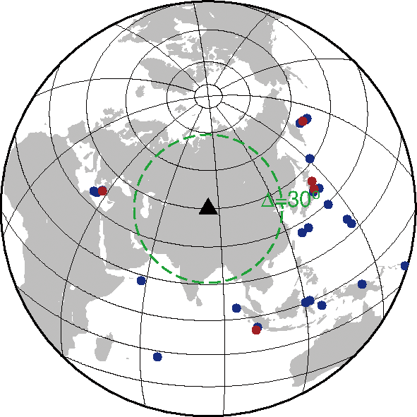
Fig.2 Azimuth-distance distribution of teleseismic events (circles)
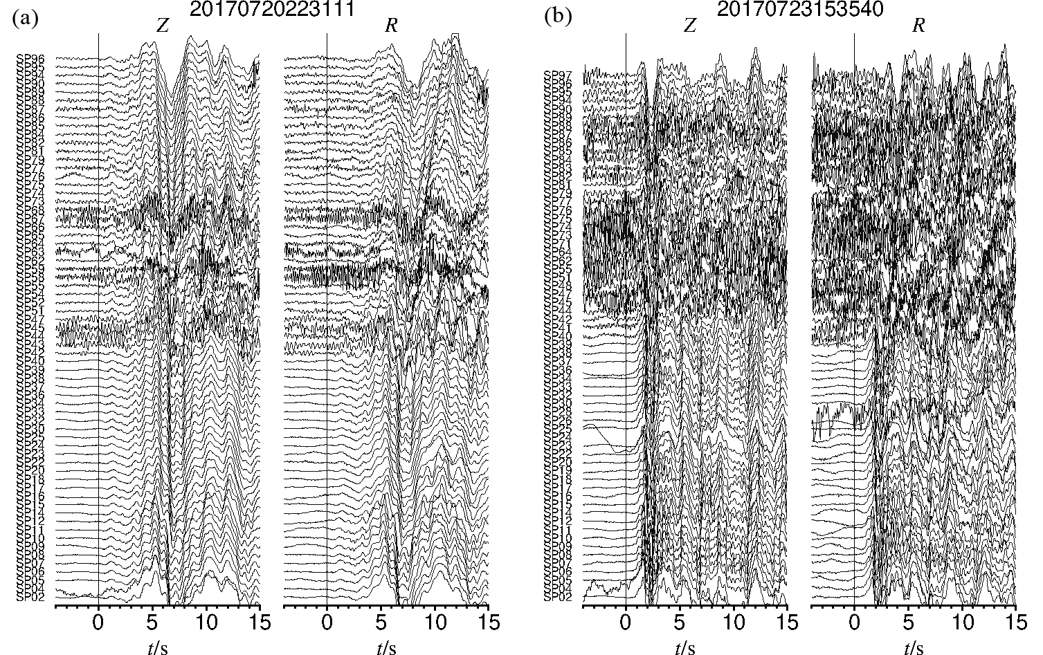
Fig.3 Teleseismic waveforms of vertical (Z) and radial (R) components for 2 earthquakes (“20170720223111” and “20170723153540”) aligned with the first P arrival with stations along survey line AA' (see Fig.1b for AA' location)
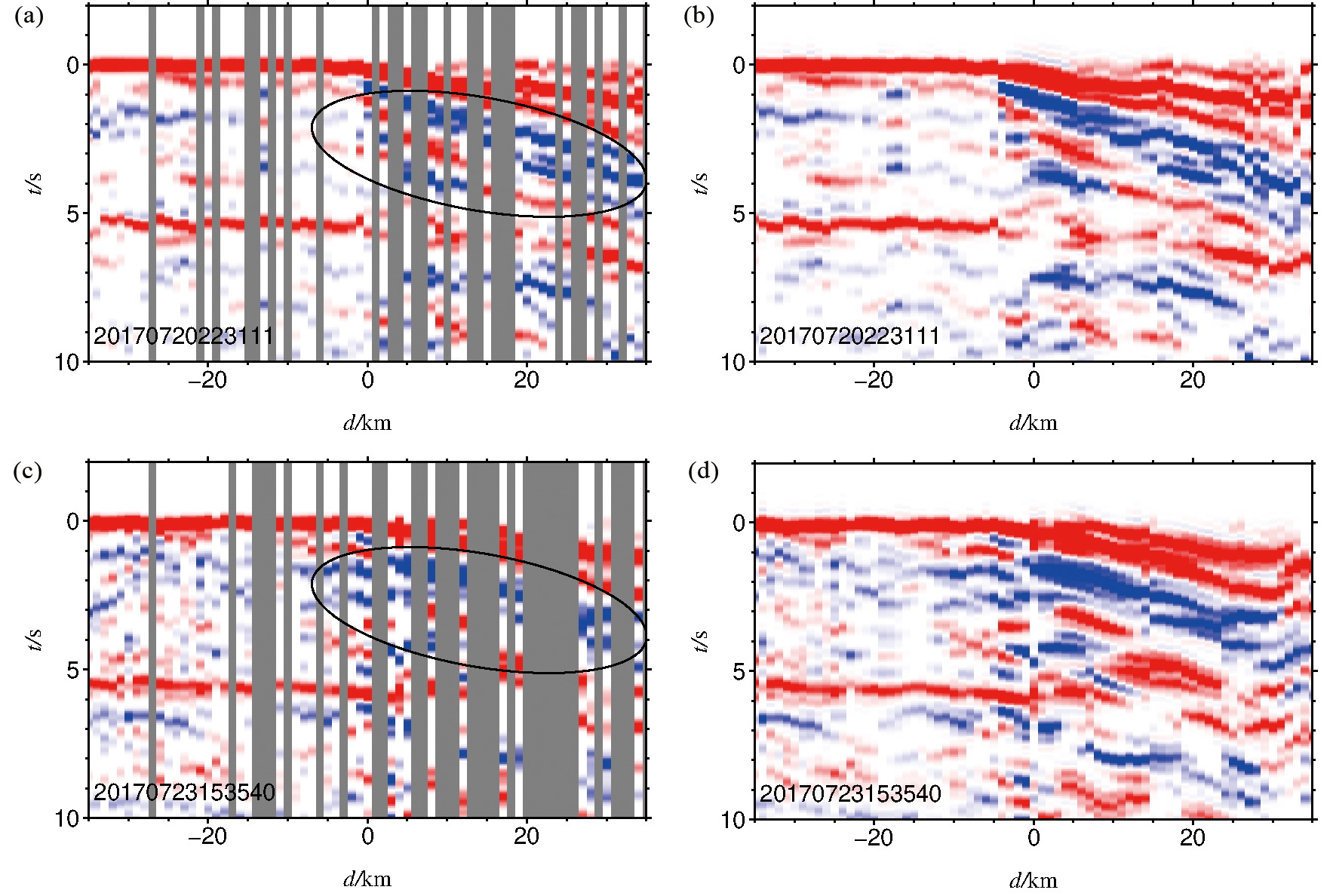
Fig.4 (a, c) RFs and (b, d) interpolated RFs of the two teleseismic events in Fig.3
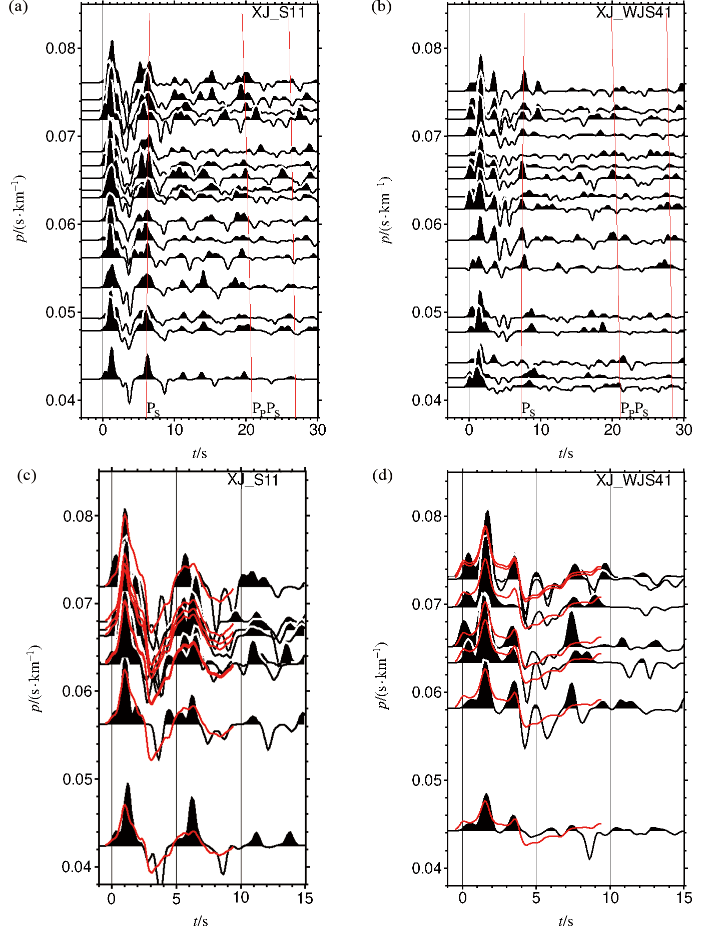
Fig.5 Receiver functions recorded for XJ_S11 and XJ_WJS41 used in NA inversion. (a, b) RFs. (c, d) Receive function waveform fitting results.
| Station | Thickness/ km | vS1/ (km·s-1) | vS2/ (km·s-1) | κ/ (vP·vS) |
|---|---|---|---|---|
| XJ_S11 | 1.3 | 0.2 | 1.8 | 2.33 |
| XJ_WJS41 | 3.0 | 0.5 | 2.1 | 2.44 |
Table 1 Receiver function inversion results for XJ_S11 and XJ_WJS41 using neighborhood algorithm (NA)
| Station | Thickness/ km | vS1/ (km·s-1) | vS2/ (km·s-1) | κ/ (vP·vS) |
|---|---|---|---|---|
| XJ_S11 | 1.3 | 0.2 | 1.8 | 2.33 |
| XJ_WJS41 | 3.0 | 0.5 | 2.1 | 2.44 |
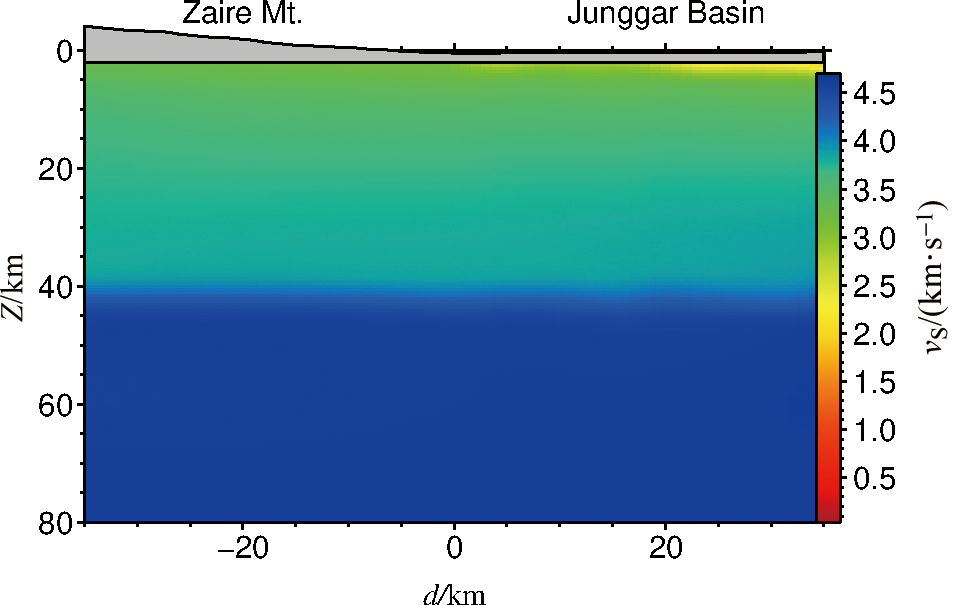
Fig.6 A 2-D S-wave velocity background model
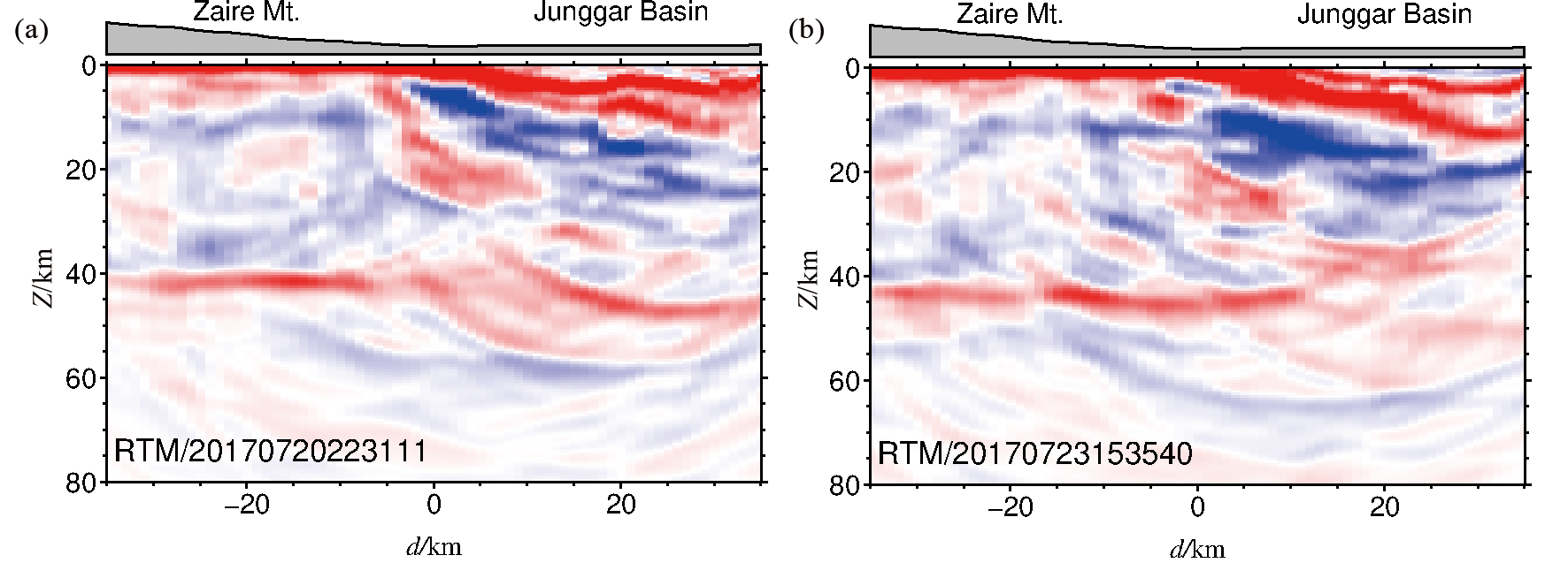
Fig.7 RF-RTM imaging results for the two teleseismic events in Fig.3
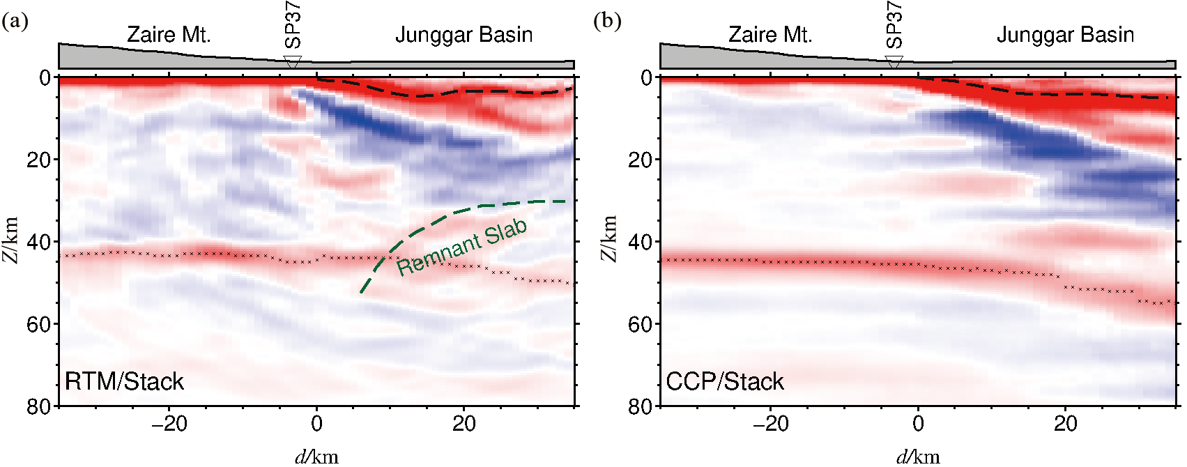
Fig.8 The imaging results. (a) RF-RTM and (b) CCP stacking results.
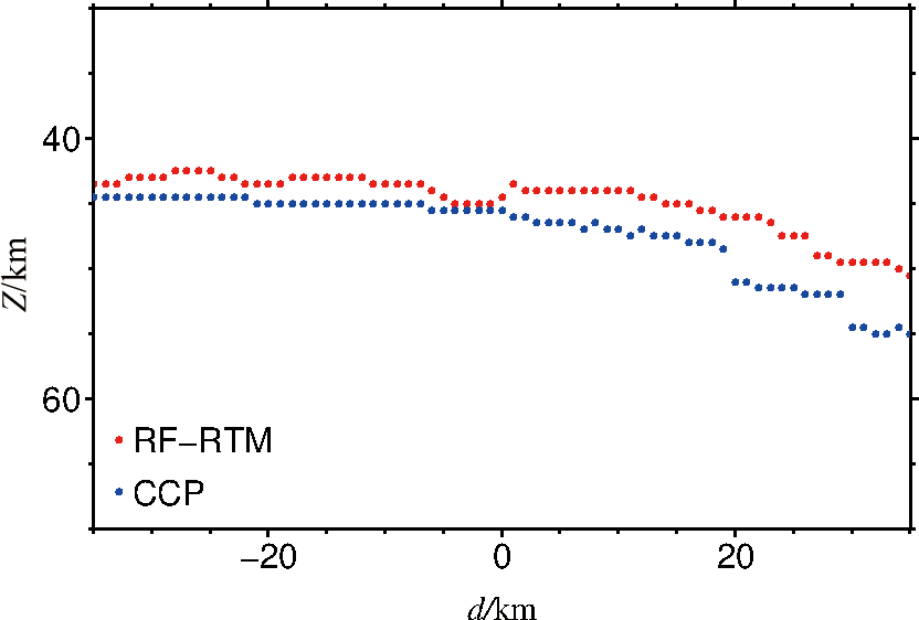
Fig.9 Moho location from RF-RTM and CCP stacking imaging
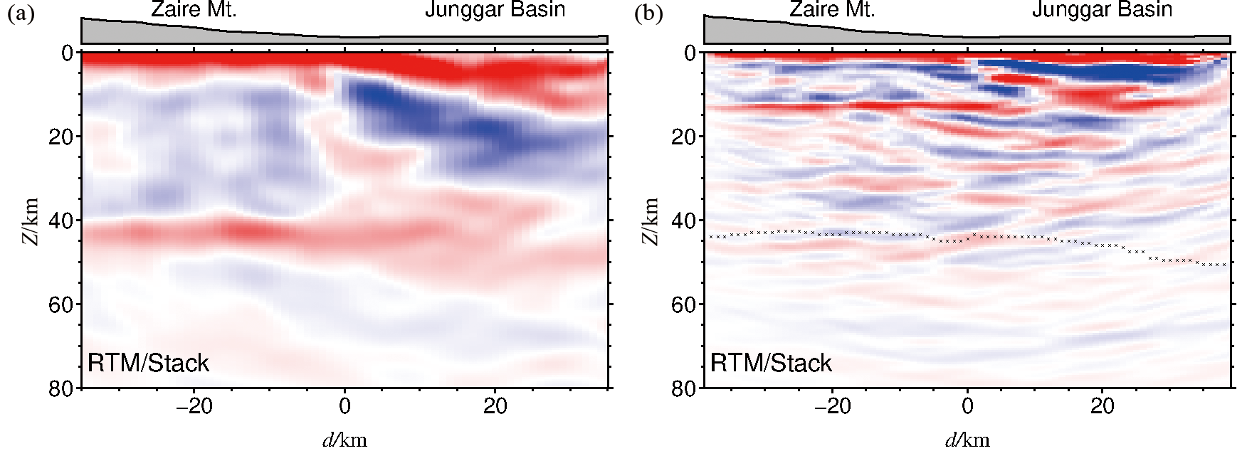
Fig.10 Analysis diagram of influencing factors. (a) RF-RTM stacking images with low-pass filtered RFs using a 1 Hz Gaussian filter. (b) RF-RTM stacking images using PpPs phases. Black cross represents Moho discontinuity location.
| [1] |
FENG Y, COLEMAN R G, TILTON G, et al. Tectonic evolution of the West Junggar region, Xinjiang, China[J]. Tectonics, 1989, 8 (4): 729-752.
DOI URL |
| [2] |
WINDLEY B F, ALEXEIEV D, XIAO W, et al. Tectonic models for accretion of the central Asian Orogenic Belt[J]. Journal of the Geological Society, 2007, 164 (1): 31-47.
DOI URL |
| [3] |
XIAO W J, WINDLEY B F, YUAN C, et al. Paleozoic multiple subduction-accretion processes of the southern Altaids[J]. American Journal of Science, 2009, 309 (3): 221-270.
DOI URL |
| [4] |
ZHANG J E, XIAO W J, HAN C M, et al. A Devonian to Carboniferous intra-oceanic subduction system in western Junggar, NW China[J]. Lithos, 2011, 125(1/2): 592-606.
DOI URL |
| [5] |
KRUK N N, RUDNEV S N, VLADIMIROV A G, et al. Early-Middle Paleozoic granitoids in Gorny Altai, Russia: implications or continental crust history and magma sources[J]. Journal of Asian Earth Sciences, 2011, 42(5): 928-948.
DOI URL |
| [6] |
KRONER A, KOVACH V, BELOUSOVA E, et al. Reassessment of continental growth during the accretionary history of the central Asian Orogenic Belt[J]. Gondwana Research, 2014, 25(1): 103-125.
DOI URL |
| [7] |
LI D, HE D, SANTOSH M, et al. Tectonic framework of the northern Junggar Basin Part II: the island arc basin system of the western Luliang Uplift and its link with the West Junggar terrane[J]. Gondwana Research, 2015, 27(3): 1110-1130.
DOI URL |
| [8] |
CHEN Y, WU T, GAN L, et al. Provenance of the early to mid-Paleozoic sediments in the northern Alxa area: implications for tectonic evolution of the southwestern central Asian Orogenic Belt[J]. Gondwana Research, 2019, 67: 115-130.
DOI URL |
| [9] |
XIAO W J, ZHANG L C, QIN K Z, et al. Paleozoic accretionary and collisional tectonics of the eastern Tianshan (China): implication for the continental growth of central Asia[J]. American Journal of Science, 2004, 304(4): 370-395.
DOI URL |
| [10] | BUCKMAN S, AITCHISON J. Tectonic evolution of Paleozoic terranes in West Junggar, Xinjiang, NW China[M]// Aspects of the tectonic evolution of China. London: Geological Society, 2004, 226(1): 101-129. |
| [11] |
COLEMAN R G. Continental growth of Northwest China[J]. Tectonics, 1989, 8(3): 621-635.
DOI URL |
| [12] |
王小军, 宋永, 郑孟林, 等. 准噶尔西部陆内盆地构造演化与油气聚集[J]. 地学前缘, 2022, 29(6): 188-205.
DOI |
| [13] |
VASYUKOVA E A, LZOKH A E, BORISENKO A S, et al. Early Mesozoic lamprophyres in Gorny Altai: petrology and age boundaries[J]. Russian Geology and Geophysics, 2011, 52(12): 1574-1591.
DOI URL |
| [14] |
CHEN B, ARAKAWA Y. Elemental and Nd-Sr isotopic geochemistry of granitoids from the west Junggar foldbelt (NW China), with implications for Phanerozoic continental growth[J]. Geochimica et Cosmochimica Acta, 2005, 69(5): 1307-1320.
DOI URL |
| [15] | XU X, HE G, LI H, et al. Basic characteristics of the Karamay ophiolitic mélange, Xinjiang, and its zircon SHRIMP dating[J]. Geology in China, 2006, 33(3): 470-475. |
| [16] |
KRONER A, KOVACH V, BELOUSOVA E, et al. Reassessment of continental growth during the accretionary history of the central Asian Orogenic Belt[J]. Gondwana Research, 2014, 25(1): 103-125.
DOI URL |
| [17] | 马绪宣. 中国中天山前寒武纪构造属性及古生代构造演化[D]. 南京: 南京大学, 2014. |
| [18] |
CHEN Y, WU T, GAN L, et al. Provenance of the early to mid-Paleozoic sediments in the northern Alxa area: implications for tectonic evolution of the southwestern central Asian Orogenic Belt[J]. Gondwana Research, 2019, 67: 115-130.
DOI URL |
| [19] | HE G Q, LIU J B, ZHANG Y Q, et al. Karamay ophiolitic mélange formed during early Paleozoic in West Junggar Basin[J]. Acta Petrologica Sinica, 2007, 23(7): 1573-1576. |
| [20] |
杨高学, 李永军. 西准噶尔洋中海山及其俯冲带处地质效应[J]. 地学前缘, 2015, 22(6): 233-240.
DOI |
| [21] |
SENGÖR A M C, NATAL’IN B A, BURTMAN V S. Evolution of the Altaids tectonic collage and Palaeozoic crustal growth in Eurasia[J]. Nature, 1993, 364(6435): 299-307.
DOI |
| [22] |
JAHN B M, WU F, CHEN B. Massive granitoid generation in central Asian: Nd isotope evidence and implication for continental growth in the Phanerozoic[J]. Episodes, 2000, 23(2): 82-92.
DOI URL |
| [23] |
LI D, HE D, FAN C. Geochronology and Sr-Nd-Hf isotopic composition of the granites, enclaves, and dikes in the Karamay area, NW China: insights into late Carboniferous crustal growth of west Junggar[J]. Geoscience Frontiers, 2015, 6(2): 153-173.
DOI URL |
| [24] | ZHANG C, HUANG X. The ages and tectonic settings of ophiolites in West Junggar, Xinjiang[J]. Geological Review, 1992, 38(6): 509-524. |
| [25] | SU Y, TANG H, HOU G, et al. Geochemistry of aluminous A-type granites along Darabut tectonic belt in West Junggar, Xinjiang[J]. Geochimica, 2006, 35(1): 55-67. |
| [26] |
XIAO W, HAN C, YUAN C, et al. Middle Cambrian to Permian subduction-related accretionary orogenesis of Northern Xinjiang, NW China: implications for the tectonic evolution of central Asia[J]. Journal of Asian Earth Sciences, 2008, 32(2/3/4): 102-117.
DOI URL |
| [27] | 李锦轶, 何国琦, 徐新, 等. 新疆北部及邻区地壳构造格架及其形成过程的初步探讨[J]. 地质学报, 2006, 80(1): 148-168. |
| [28] |
YANG G, LI Y, GU P, et al. Geochronological and geochemical study of the Darbut Ophiolitic Complex in the West Junggar (NW China): implications for petrogenesis and tectonic evolution[J]. Gondwana Research, 2012, 21(4): 1037-1049.
DOI URL |
| [29] |
XU Y X, YANG B, ZHANG S, et al. Magnetotelluric imaging of a fossil paleozoic intraoceanic subduction zone in western Junggar, NW China[J]. Journal of Geophysical Research: Solid Earth, 2016, 121(6): 4103-4117.
DOI URL |
| [30] |
GENG H, SUN M, YUAN C, et al. Geochemical, Sr-Nd and zircon U-Pb-Hf isotopic studies of Late Carboniferous magmatism in the West Junggar, Xinjiang: implications for ridge subduction?[J]. Chemical Geology, 2009, 266(3/4): 364-389.
DOI URL |
| [31] |
ALLEN M, VINCENT S. Fault reactivation in the Junggar region, Northwest China: the role of basement structures during Mesozoic-Cenozoic compression[J]. Journal of the Geological Society, 1997, 154(1): 151-155.
DOI URL |
| [32] |
ZHANG S, XU Y X, JIANG L, et al. Electrical structures in the northwest margin of the Junggar Basin: implications for its late Paleozoic geodynamics[J]. Tectonophysics, 2017, 717: 473-483.
DOI URL |
| [33] |
LIU Y, JUNGE A, YANG B, et al. Electrically anisotropic crust from three dimensional magnetotelluric modeling in the western Junggar, NW China[J]. Journal of Geophysical Research: Solid Earth, 2019, 124(9): 9474-9494.
DOI URL |
| [34] |
XU Y X, YANG B, ZHAN A, et al. Magnetotelluric imaging of a fossil oceanic plate in northwestern Xinjiang, China[J]. Geology, 2020, 48 (4): 385-389.
DOI URL |
| [35] |
WU S C, HUANG R, XU Y X, et al. Seismological evidence for a remnant oceanic slab in the western Junggar, Northwest China[J]. Journal of Geophysical Research: Solid Earth, 2018, 123(5): 4157-4170.
DOI URL |
| [36] | HUA Y, XU Y X, ZHAO D, et al. Upper mantle tomography of the western Junggar: implication for its geodynamic evolution[J]. Physics of the Earth and Planetary, 2020, 299. DOI: 10.1016/j.pepi.2019.106405. |
| [37] | 许顺芳, 陈超, 杜劲松, 等. 西准噶尔及邻区的岩石圈密度结构特征及其构造意义[J]. 地球科学: 中国地质大学学报, 2015, 40(9): 1556-1565. |
| [38] |
ZHAO J, DENG G, XU Q, et al. Basement structure and properties of the southern Junggar Basin[J]. Journal of Geodynamics, 2018, 121: 26-35.
DOI URL |
| [39] |
ZHANG A, AFONSO J, XU Y, et al. The deep lithospheric structure of the Junggar terrane, NW China: implications for its origin and tectonic evolution[J]. Journal of Geophysical Research: Solid Earth, 2019, 124(11): 11615-11638.
DOI URL |
| [40] | JIANG X H, ZHU L P, HU S Q, et al. 3-D reverse time migration of teleseismic receiver functions using the phase shift plus interpolation method[J]. Geophysical Journal International, 2019, 271(2): 1047-1057. |
| [41] |
LIGORRIA J P, AMMON C J. Iterative deconvolution and receiver-function estimation[J]. Bulletin of the Seismological Society of America, 1999, 89(5): 1395-1400.
DOI URL |
| [42] |
HU S Q, JIANG X H, ZHU L P, et al. Wavefiled reconstruction of teleseismic receiver function with the stretching-and-squeezing interpolation method[J]. Seismological Research Letters, 2019, 90 (2A): 716-726.
DOI URL |
| [43] | 姜小欢. 远震接收函数三维逆时偏移方法研究及其应用[D]. 武汉: 中国地质大学(武汉), 2019. |
| [44] | WHITMORE N D. Iterative depth migration by backward time propagation[C]. The 53rd SEG Meeting, Las Vegas. 1983: 382-385. |
| [45] | CLAERBOUT J F. Toward a unified theory of reflector mapping[J]. Geophysics, 1971, 36(3): 461-481. |
| [46] | BIONDI B, SHAN G. Prestack imaging of overturned reflections by reverse time migration[C]// 72nd annual international meeting, SEG, expanded abstracts. 2002: 1284-1287. |
| [47] |
GAZDAG J, SGUAZZERO P. Migration of seismic data by phase shift plus interpolation[J]. Geophysics, 1984, 49 (2): 124-131.
DOI URL |
| [48] |
WHITMORE N D, LINES L R. Vertical seismic profiling depth migration of a salt dome flank[J]. Geophysics, 1986, 51(5): 1087.
DOI URL |
| [49] |
WU S C, YANG Y, XU Y, et al. A fossil oceanic lithosphere preserved inside a continent[J]. Geology, 2023, 51(2): 204-208.
DOI URL |
| [50] |
SAMIBRIDGE M. Geophysical inversion with a neighbourhood algorithm: I.Searching a parameter space[J]. Geophysical Journal International, 1999, 138(2): 479-494.
DOI URL |
| [51] |
SAMIBRIDGE M. Geophysical inversion with a neighbourhood algorithm: II.Appraising the ensemble[J]. Geophysical Journal International, 1999, 138(3): 727-746.
DOI URL |
| [52] |
ZHU L P. Crustal structure across the San Andreas Fault, southern California from teleseismic converted waves[J]. Earth and Planetary Science Letters, 2000, 179(1): 183-190.
DOI URL |
| [53] |
MA C, XIAO W, WINDLEY B F, et al. Tracing a subducted ridge-transform system in a late Carboniferous accretionary prism of the southern Altaids: orthogonal sanukitoid dyke swarms in western Junggar, NW China[J]. Lithos, 2012, 140/141: 152-165.
DOI URL |
| [54] |
YIN J, LONG X, YUAN C, et al. A late Carboniferous-early Permian slab window in the West Junggar of NW China: geochronological and geochemical evidence from mafic to intermediate dikes[J]. Lithos, 2013, 175/176: 146-162.
DOI URL |
| [55] |
ZHANG J, XIAO W, HAN C, et al. Kinematics and age constraints of deformation in a late Carboniferous accretionary complex in western Junggar, NW China[J]. Gondwana Research, 2011, 19(4): 958-974.
DOI URL |
| [1] | CAI Wei, LU Zhanwu, HUANG Rong, LI Wenhui, LUO Yinhe, WANG Guangwen, MU Qing, CHENG Yongzhi, CHEN Si, WANG Guan, CHEN Zilong. Crustal structure beneath the Cuonadong dome in southern Tibet revealed by receiver functions from a short-period dense array [J]. Earth Science Frontiers, 2024, 31(1): 170-180. |
| [2] | LI Qiang, WU Jianping. Crustal thickness and Poisson’s ratio beneath the continental margin of southeastern China and the tectonic implications [J]. Earth Science Frontiers, 2023, 30(5): 408-419. |
| [3] | MU Qing, HUANG Rong, YAN Jiayong, LU Zhanwu, LUO Yinhe, ZHANG Yongqian, JIANG Xiaohuan, WEN Hongbin, WEI Penglong, ZHOU Wanli. Constraining the crustal structure of the southern segment of the north-south gravity lineament by the receiver function H-κ-c method [J]. Earth Science Frontiers, 2023, 30(5): 369-383. |
| [4] | CHENG Yongzhi, GAO Rui, LU Zhanwu, LI Wenhui, WANG Guangwen, CHEN Si, WU Guowei, CAI Yuguo. Deep structure and dynamics of the eastern segment of the Qilian orogenic belt in the northeastern margin of the Tibetan Plateau [J]. Earth Science Frontiers, 2023, 30(5): 314-333. |
| [5] | TONG Xiaofei, XU Xiao, GUO Xiaoyu, LI Chunsen, XIANG Bo, YU Jiahao, LUO Xucong, YUAN Zizhao, LIN Yanqi, SHI Hongcheng. Receiving function imaging reveals the crustal structure of the East Kunlun fault zone and surrounding areas [J]. Earth Science Frontiers, 2023, 30(4): 270-282. |
| [6] | XU Xiao, YU Jiahao, XIANG Bo, GUO Xiaoyu, LI Chunsen, LUO Xucong, TONG Xiaofei, YUAN Zizhao, LIN Yanqi, SHI Hongcheng. Deep crustal structure of the southeastern Lhasa Terrane [J]. Earth Science Frontiers, 2023, 30(3): 221-232. |
| [7] | LI Chunsen, XU Xiao, XIANG Bo, GUO Xiaoyu, WU You, WU Jiajie, LUO Xucong, YU Jiahao, TONG Xiaofei, YUAN Zizhao, LIN Yanqi. Moho geometry in the eastern North Himalayan tectonic belt: An example of the receiver function 3DCCP method [J]. Earth Science Frontiers, 2023, 30(2): 57-67. |
| [8] | WANG Xiaojun, SONG Yong, ZHENG Menglin, GUO Xuguang, WU Haisheng, REN Haijiao, WANG Tao, CHANG Qiusheng, HE Wunjun, WANG Xiatian, GUO Jianchen, HUO Jinjie. Tectonic evolution of and hydrocarbon accumulation in the western Junggar Basin [J]. Earth Science Frontiers, 2022, 29(6): 188-205. |
| [9] | ZHOU Pengzhe, GAO Rui, YE Zhuo. Crustal anisotropy study in the central Qilian Mountains: Evidence from teleseismic P wave receiver functions [J]. Earth Science Frontiers, 2022, 29(4): 265-277. |
| [10] | WU Jiajie, XU Xiao, GUO Xiaoyu, LU Zhanwu, WU You, XIANG Bo, YU Yang, LI Chunsen, YU Jiahao, TONG Xiaofei, LUO Xucong. Crustal structure of the Cona rift, eastern Himalaya [J]. Earth Science Frontiers, 2022, 29(4): 221-230. |
| [11] | WU Guowei, XIONG Xiaosong, GAO Rui, CHEN Xuanhua, LI Yingkang, WANG Guan, WANG Xiaocheng, REN Haidong. 2D Tomographic imaging of the P-wave velocity structure in the upper crust beneath the southern Beishan tectonic belt [J]. Earth Science Frontiers, 2022, 29(2): 402-415. |
| [12] | Valentina V. MORDVINOVA, Maria A. KHRITOVA, Elena A. KOBELEVA, Mikhail M. KOBELEV, Evgeniy Kh. TURUTANOV, Victor S. KANAYKIN. Detailed structure of the Earth’s crust and upper mantle of the Severomuysk segment of the Baikal rift zone according to teleseismic data [J]. Earth Science Frontiers, 2022, 29(2): 378-392. |
| [13] | LU Zhanwu, GAO Rui, Simon KLEMPERER, WANG Haiyan, DONG Shuwen, LI Wenhui, LI Hongqiang. Crustal-scale duplexing beneath the Yarlung Zangbo suture in the western Himalaya [J]. Earth Science Frontiers, 2022, 29(2): 210-217. |
| [14] | BIAN Baoli,ZHANG Jingkun,WU Junjun,LI Zonghao,WANG Yan,CAO Jian. Re-characterization of the Dazhuluogou strike-slip fault in northwestern Junggar Basin and the implications for hydrocarbon accumulation [J]. Earth Science Frontiers, 2019, 26(1): 238-247. |
| [15] | LI Zong-Xing, GAO Dun, LI Wen-Fei, TUN Jian-Feng. The characteristics of geothermal field and controlling factors in Qaidam Basin, Northwest China. [J]. Earth Science Frontiers, 2016, 23(5): 23-32. |
| Viewed | ||||||
|
Full text |
|
|||||
|
Abstract |
|
|||||