Earth Science Frontiers ›› 2023, Vol. 30 ›› Issue (5): 369-383.DOI: 10.13745/j.esf.sf.2023.7.31
Previous Articles Next Articles
MU Qing1,2,3( ), HUANG Rong2,3,*(), YAN Jiayong1, LU Zhanwu4, LUO Yinhe2,3, ZHANG Yongqian1, JIANG Xiaohuan5,6, WEN Hongbin1,2,3, WEI Penglong2,3, ZHOU Wanli2,3
Received:2023-07-20
Revised:2023-07-28
Online:2023-09-25
Published:2023-10-20
CLC Number:
MU Qing, HUANG Rong, YAN Jiayong, LU Zhanwu, LUO Yinhe, ZHANG Yongqian, JIANG Xiaohuan, WEN Hongbin, WEI Penglong, ZHOU Wanli. Constraining the crustal structure of the southern segment of the north-south gravity lineament by the receiver function H-κ-c method[J]. Earth Science Frontiers, 2023, 30(5): 369-383.
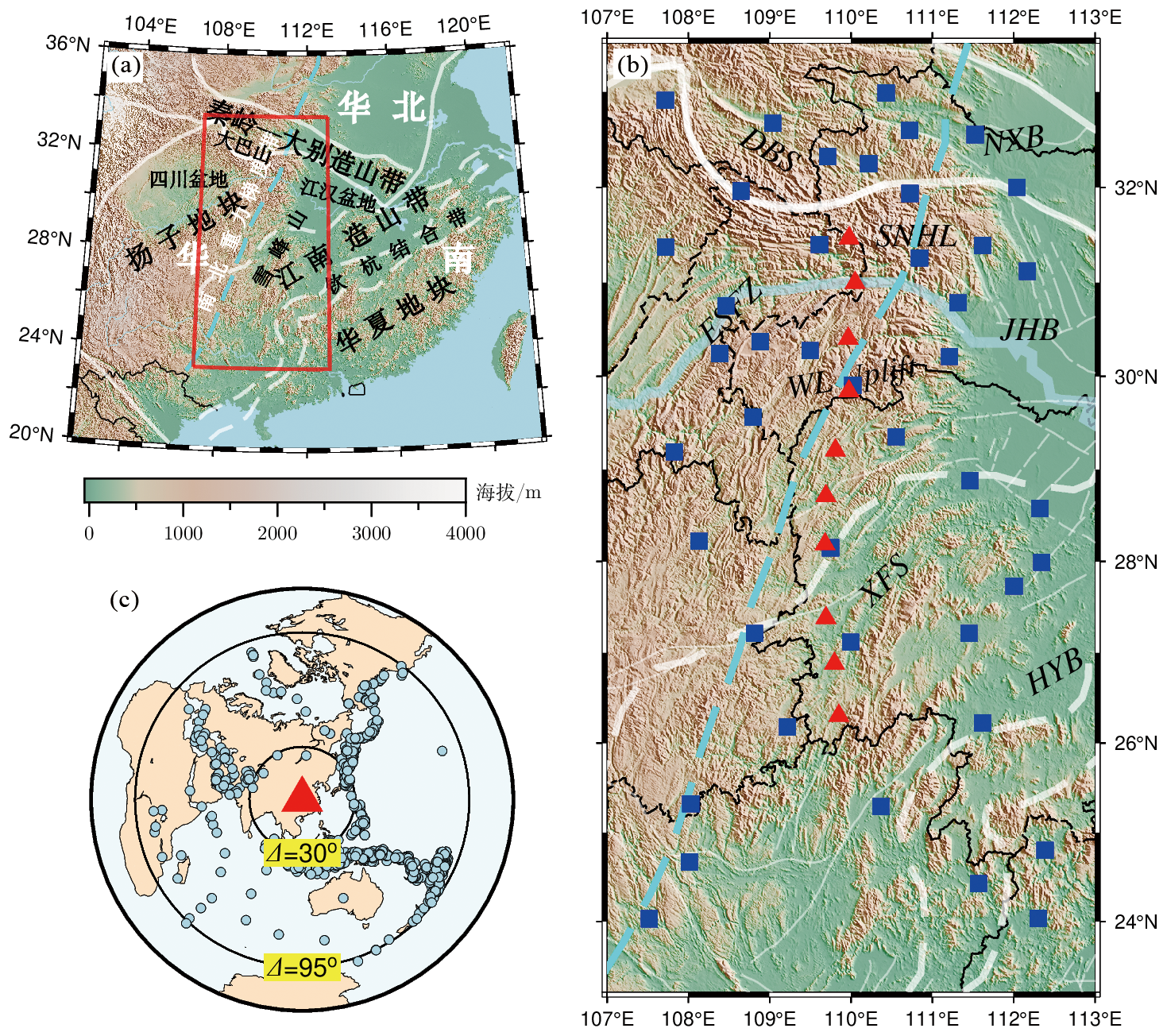
Fig.1 Basic information. (a) Tectonic setting of southern China and location of the study area. (b) Distribution of seismic stations. (c) Distribution of teleseismic events in East Asia.
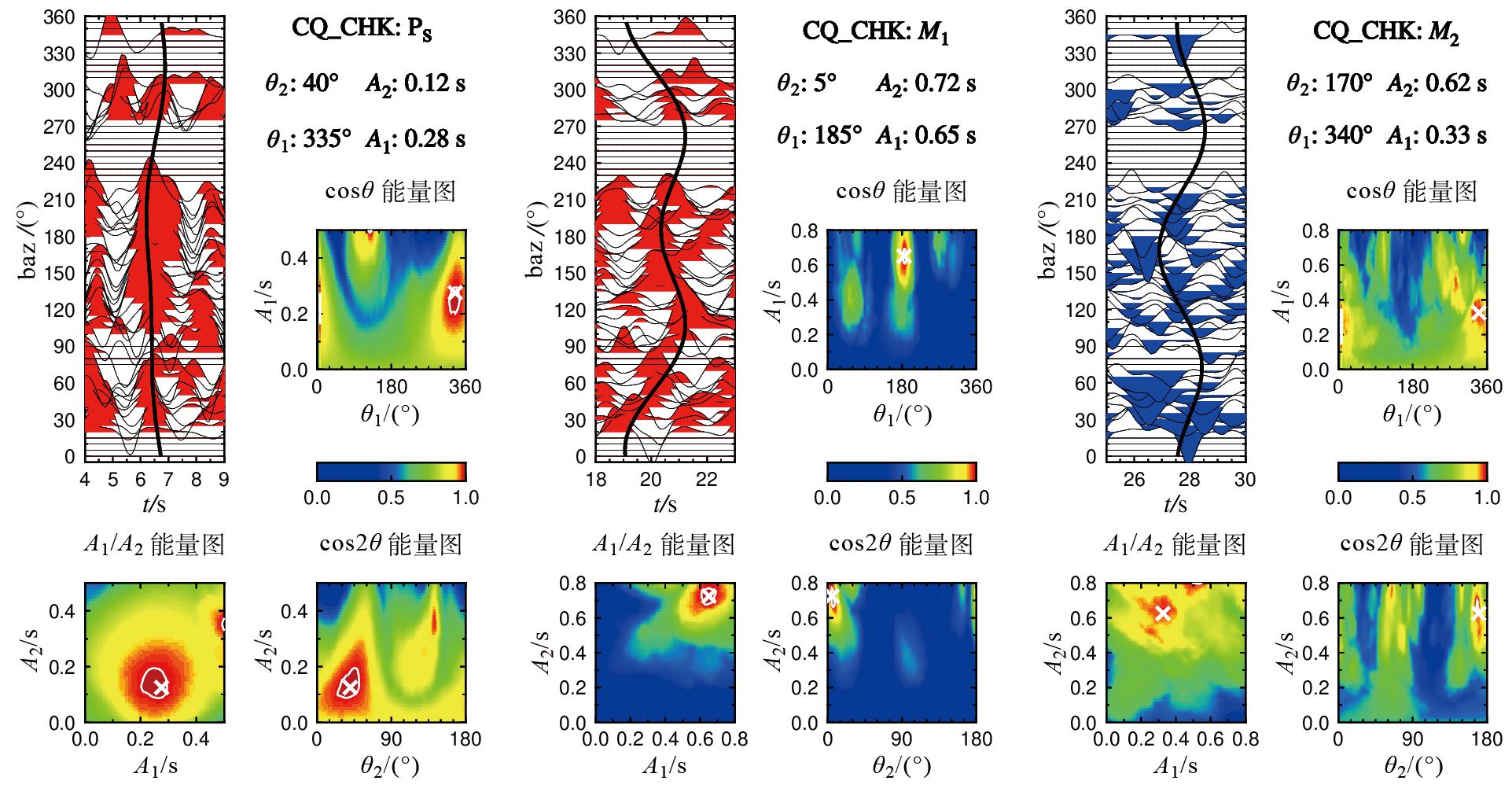
Fig.2 The harmonic fitting results of converted PS phase (left) and two multi-phases (M1/M2, middle/right) for CQ_CHK station
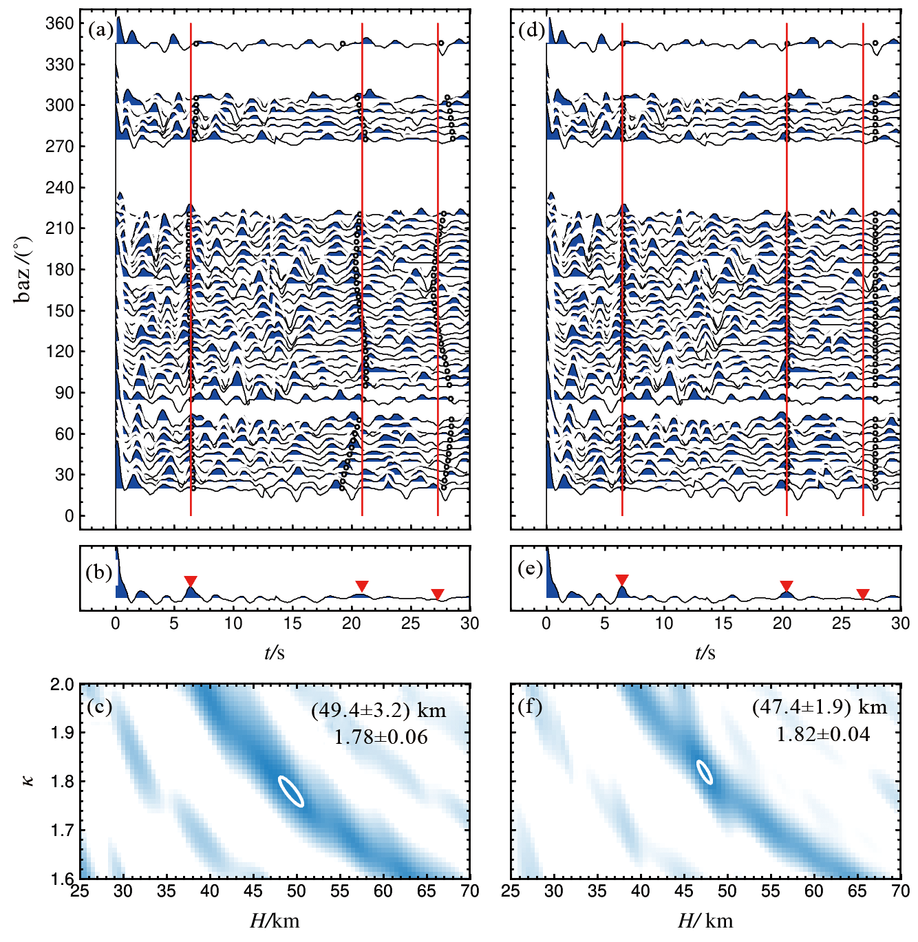
Fig.3 Comparison of stacking results before (a, b, c) and after (d, e, f) harmonic fitting correction for CQ_CHK station. where the red lines and red triangles mark the reference arrivals (from left to right) of PS, M1 and M2 phases, respectively.

Fig.4 Comparison of our results with previous studies from [19-20,23,27,35]. (a) Statistics of the Moho converted PS arrivalsfrom different H-κ stacking studies, where the gray histograms show the standard variance among all results;(b) and (c) represent comparison analysis of crustal thickness (H) and vP/vS ratio (κ), separately,where the solid line and dashed lines indicate reference line and 5 km (H) and 0.1 (κ) variances, respectively.

Fig.5 Histograms of standard deviation of H-κ stacking results before and after harmonic fitting corrections. (a) Crustal thickness. (b) vP/vS ratio.

Fig.6 Crustal thickness results for the study area. (a) Crustal thickness map after interplate calibration. Squares indicate negative corrections and circles positive corrections; bold gray line indicates abrupt change in Moho depth. (b) Thickness values by individual stations from ours and previous studies adapted from [22-23,38].

Fig.7 vP/vS ratio results for the study area. (a) Variation of vP/vS ratio after interplate calibration. See Fig.6 for more detail. (b) vP/vS ratio values by individual stations from ours and previous studies adapted from [22-23,38].

Fig.8 Moho interface map of the study area showing the degree of interface tilting (a) and crustal anisotropy (b-d) beneath individual stations
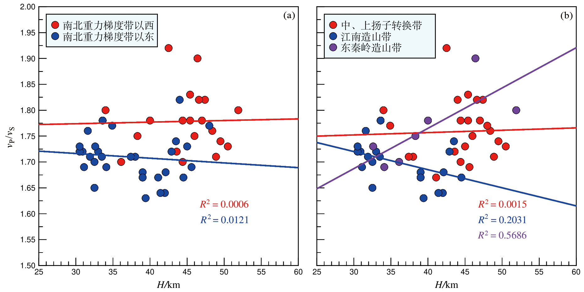
Fig.9 Correlation analysis between crustal thickness and average crustal vP/vS ratio
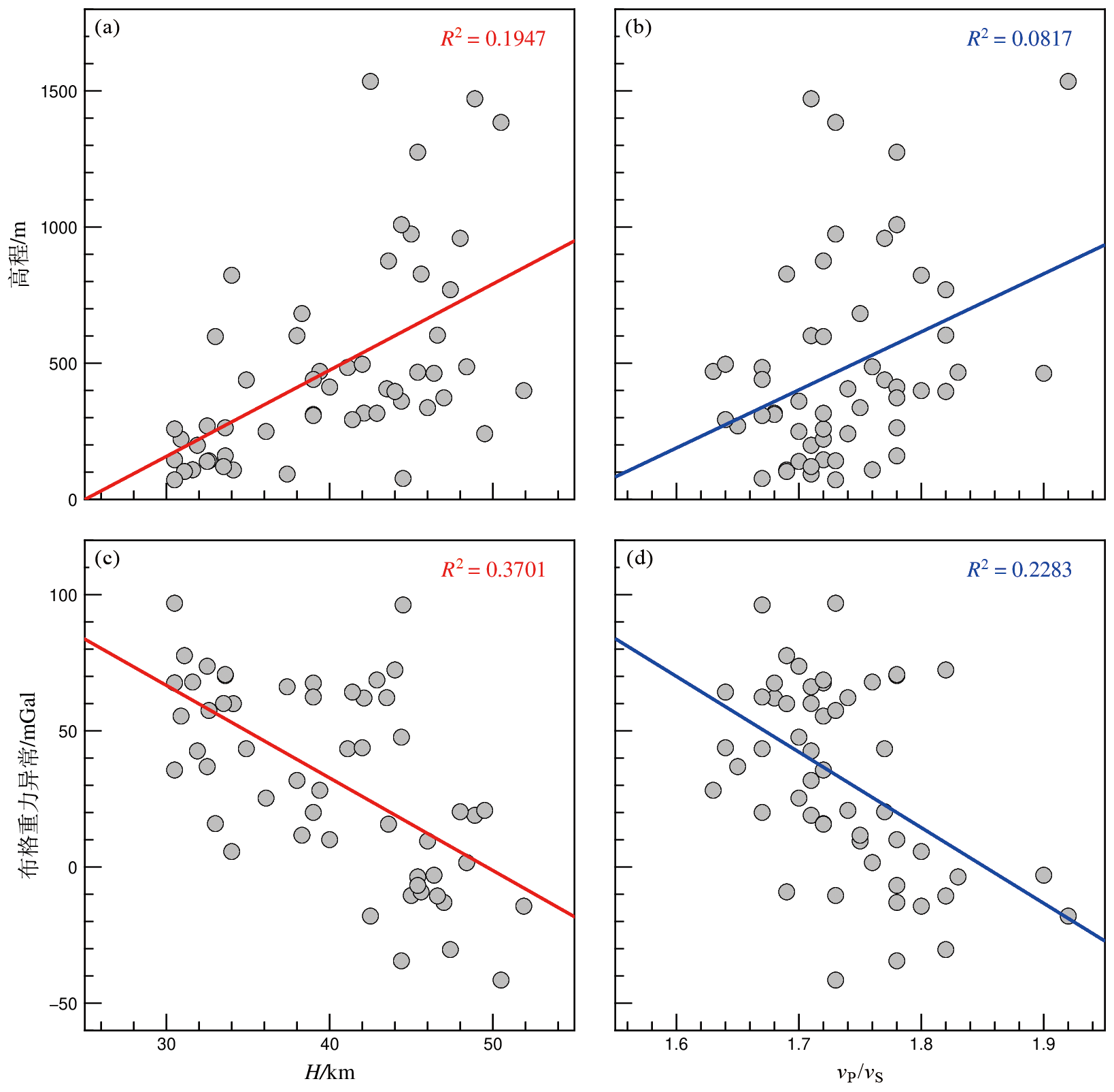
Fig.10 Correlation analysis between variables. (a) Altitude and crustal thickness; (b) Bouguer Gravity anomaly and crustal thickness; (c) altitude and vP/vS ratio; (d) Bouguer Gravity anomaly and vP/vS ratio.
| [1] | 常印佛, 董树文, 黄德志. 论中-下扬子 “一盖多底” 格局与演化[J]. 火山地质与矿产, 1996, 17(1): 1-15. |
| [2] | 张国伟, 郭安林, 王岳军, 等. 中国华南大陆构造与问题[J]. 中国科学: 地球科学, 2013, 43(10): 1553-1582. |
| [3] | 何卫红, 张宗言, 肖异凡, 等. 华南南华纪—二叠纪沉积大地构造演化[J]. 地球科学: 中国地质大学学报, 2014, 39(8): 929-953. |
| [4] | 严加永, 吕庆田, 罗凡, 等. 钦杭何在?来自综合地球物理探测的认识[J]. 中国地质, 2019, 46(4): 690-703. |
| [5] | 黄汲清, 任纪舜, 姜春发, 等. 中国大地构造基本轮廓[J]. 地质学报, 1977, 51(2): 117-135. |
| [6] | 杨宝俊, 刘万崧, 王喜臣, 等. 中国东部大兴安岭重力梯级带域地球物理场特征及其成因[J]. 地球物理学报, 2005, 48(1): 86-97. |
| [7] | 徐义刚. 太行山重力梯度带的形成与华北岩石圈减薄的时空差异性有关[J]. 地球科学: 中国地质大学学报, 2006, 31(1): 14-22. |
| [8] | 马开义, 孙德梅. 武陵山重力梯度带的地质构造意义[G]. 中国地质科学院矿床地质研究所文集. 北京: 地质出版社, 1987. |
| [9] | 李秋生, 高锐, 王海燕, 等. 川东北-大巴山盆山体系岩石圈结构及浅深变形耦合[J]. 岩石学报, 2011, 27(3): 612-620. |
| [10] |
DONG S, GAO R, YIN A, et al. What drove continued continent-continent convergence after ocean closure? Insights from high-resolution seismic-reflection profiling across the Daba Shan in central China[J]. Geology, 2013, 41(6): 671-674.
DOI URL |
| [11] |
YAN D P, ZHOU M F, SONG H L, et al. Origin and tectonic significance of a Mesozoic multi-layer over-thrust system within the Yangtze Block (South China)[J]. Tectonophysics, 2003, 361(3/4): 239-254.
DOI URL |
| [12] | 张永谦, 严加永, 李春麟, 等. 川东-武陵山地区的深部结构与陆内变形机制初探[J]. 地球物理学进展, 2021, 36(6): 2423-2432. |
| [13] | 舒良树. 华南构造演化的基本特征[J]. 地质通报, 2012, 31(7): 1035-1053. |
| [14] | 董长春, 舒立旻, 舒良树. 中国东南部晚中生代盆岭格局及其构造-岩浆作用[J]. 高校地质学报, 2023, 29(2): 223-239. |
| [15] |
ZHANG Z, BAI Z, MOONEY W, et al. Crustal structure across the Three Gorges area of the Yangtze platform, central China, from seismic refraction/wide-angle reflection data[J]. Tectonophysics, 2009, 475(3/4): 423-437.
DOI URL |
| [16] | 邓阳凡, 李守林, 范蔚茗, 等. 深地震测深揭示的华南地区地壳结构及其动力学意义[J]. 地球物理学报, 2011, 54(10): 2560-2574. |
| [17] |
DONG S, ZHANG Y, ZHANG F, et al. Late Jurassic-Early Cretaceous continental convergence and intracontinental orogenesis in East Asia: a synthesis of the Yanshan Revolution[J]. Journal of Asian Earth Sciences, 2015, 114: 750-770.
DOI URL |
| [18] | 李英康, 高建伟, 韩健, 等. 扬子块体两侧造山带地壳推覆的地球物理证据及其地质意义[J]. 中国科学: 地球科学, 2019, 49(4): 687-705. |
| [19] |
HE C, DONG S, SANTOSH M. Seismic evidence for a geosuture between the Yangtze and Cathaysia Blocks, South China[J]. Scientific Reports, 2013, 3(1): 2200.
DOI |
| [20] |
XU X, DING Z, SHI D, et al. Receiver function analysis of crustal structure beneath the eastern Tibetan Plateau[J]. Journal of Asian Earth Sciences, 2013, 73: 121-127.
DOI URL |
| [21] |
HUANG R, ZHU L, XU Y. Crustal structure of Hubei Province of China from teleseismic receiver functions: evidence for lower crust delamination[J]. Tectonophysics, 2014, 636: 286-292.
DOI URL |
| [22] | 司芗, 滕吉文, 刘有山, 等. 秦岭造山带与南北相邻地带远震接收函数与地壳结构[J]. 地球物理学报, 2016, 59(4): 1321-1334. |
| [23] |
WEI Z, CHEN L, LI Z, et al. Regional variation in Moho depth and Poisson’s ratio beneath eastern China and its tectonic implications[J]. Journal of Asian Earth Sciences, 2016, 115: 308-320.
DOI URL |
| [24] |
SONG P, ZHANG X, LIU Y, et al. Moho imaging based on receiver function analysis with teleseismic wavefield reconstruction: application to South China[J]. Tectonophysics, 2017, 718: 118-131.
DOI URL |
| [25] | 杨晓瑜, 李永华. 中国华南地区地壳厚度与波速比分布特征及其地质意义[J]. 地球物理学报, 2021, 64(1): 146-156. |
| [26] |
ZHANG Y, SHI D, LÜ Q, et al. The crustal thickness and composition in the eastern South China Block constrained by receiver functions: implications for the geological setting and metallogenesis[J]. Ore Geology Reviews, 2021, 130: 103988.
DOI URL |
| [27] |
LI M, WEI Y, WU T, et al. Crustal isostatic state and lower crust delamination beneath the Qinling Orogenic Belt: constraints from receiver function imaging[J]. Gondwana Research, 2022, 103: 54-63.
DOI URL |
| [28] | 陈昌昕, 吕庆田, 陈凌, 等. 华南陆块地壳厚度与物质组成: 基于天然地震接收函数研究[J]. 中国科学: 地球科学, 2022, 52(4): 760-776. |
| [29] |
ZHOU L, XIE J, SHEN W, et al. The structure of the crust and uppermost mantle beneath South China from ambient noise and earthquake tomography[J]. Geophysical Journal International, 2012, 189(3): 1565-1583.
DOI URL |
| [30] | CHEN J, PAN L, LI Z, et al. Continental reworking in the Eastern South China block and its adjacent areas revealed by F-J multimodal ambient noise tomography[J]. Journal of Geophysical Research: Solid Earth, 2022, 127(11): e2022JB024776. |
| [31] |
GUO Z, GAO X, LI T, et al. Crustal and uppermost mantle structures of the South China from joint analysis of receiver functions and Rayleigh wave dispersions[J]. Physics of the Earth and Planetary Interiors, 2018, 278: 16-25.
DOI URL |
| [32] |
LUO S, HUANG R, ZHU L, et al. The formation of the Dabashan orocline, central China: insights from high-resolution 3D crustal shear-wave velocity structure[J]. Tectonophysics, 2020, 774: 228244.
DOI URL |
| [33] |
LI M, WU T, WEI Y. Lithospheric Structure in Central-East China from joint inversion of surface-wave dispersion and CCP-derived receiver function: implications for regional tectonics[J]. Seismological Research Letters, 2022, 93(5): 2719-2730.
DOI URL |
| [34] | HAN S, ZHANG H, GAO L, et al. Joint inversion of body wave arrival times, surface wave dispersion data and receiver functions: method and application to South China[J]. Journal of Geophysical Research: Solid Earth, 2022, 127(9): e2022JB024083. |
| [35] |
GUO L, GAO R, SHI L, et al. Crustal thickness and Poisson’s ratios of South China revealed from joint inversion of receiver function and gravity data[J]. Earth and Planetary Science Letters, 2019, 510: 142-152.
DOI URL |
| [36] | 陈昌昕, 严加永, 刘卫强, 等. 武陵—江南造山带中段地壳结构及其物质组成差异: 基于地球化学和地球物理异常特征研究[J]. 地球学报, 2022, 43(6): 785-802. |
| [37] |
YAN J, LÜ Q, LUO F, et al. A gravity and magnetic study of lithospheric architecture and structures of South China with implications for the distribution of plutons and mineral systems of the main metallogenic belts[J]. Journal of Asian Earth Sciences, 2021, 221: 104938.
DOI URL |
| [38] |
LI T, JIANG M, ZHAO L, et al. Wedge tectonics in South China: constraints from new seismic data[J]. Science Bulletin, 2022, 67(14): 1496-1507.
DOI PMID |
| [39] | ZHU L, KANAMORI H. Moho depth variation in southern California from teleseismic receiver functions[J]. Journal of Geophysical Research: Solid Earth, 2000, 105(B2): 2969-2980. |
| [40] |
LI J, SONG X, WANG P, et al. A generalized H-κ method with harmonic corrections on Ps and its crustal multiples in receiver functions[J]. Journal of Geophysical Research: Solid Earth, 2019, 124(4): 3782-3801.
DOI URL |
| [41] | 刘嘉栋, 丁志峰, 武岩, 等. 利用远震接收函数研究华北克拉通北部造山带地壳厚度及泊松比[J]. 地震学报, 2022(3): 44. |
| [42] | ZHANG B, BAO X, XU Y. Distinct orogenic processes in the south-and north-central Tien Shan from receiver functions[J]. Geophysical Research Letters, 2020, 47(6): e2019GL086941. |
| [43] |
CUI Q, ZHOU Y, LI J, et al. Crustal thickness (H) and vP/vS ratio (κ) images beneath the central Tien Shan revealed by the H-κ-c method[J]. Tectonophysics, 2022, 822: 229157.
DOI URL |
| [44] | 韩如冰, 杨顶辉, 李秋生, 等. 华南东部密集台阵接收函数成像与深部动力学机制[J]. 中国科学: 地球科学, 2023, 53(6): 1295-1315. |
| [45] |
TAN P, NIE S. Crustal deformation in eastern margin of Tibetan Plateau from a dense linear seismic array[J]. Physics of the Earth and Planetary Interiors, 2021, 321: 106801.
DOI URL |
| [46] |
HAN R, YANG D, LI Q, et al. Structural boundary and deep contact relationship between the Yangtze and Cathaysia Blocks from crustal thickness gradients[J]. Frontiers in Earth Science, 2023, 10: 1065782.
DOI URL |
| [47] |
周鹏哲, 高锐, 叶卓. 祁连山中部地壳各向异性研究: 来自远震接收函数的证据[J]. 地学前缘, 2022, 29(4): 265.
DOI |
| [48] | NIE S, LI J, WU C, et al. Formation of the V-shaped conjugate strike-slip faults revealed by crustal anisotropy in the central Tibetan Plateau[J]. Journal of Asian Earth Sciences, 2023: 105725. |
| [49] |
LIGORRIA J P, AMMON C J. Iterative deconvolution and receiver-function estimation[J]. Bulletin of the Seismological Society of America, 1999, 89(5): 1395-1400.
DOI URL |
| [50] |
LI J, SONG X. Crustal structure beneath the Hi-CLIMB seismic array in the central-western Tibetan Plateau from the improved H-κ-c method[J]. Earthquake Science, 2021, 34(3): 199-210.
DOI URL |
| [51] |
ZANDT G, AMMON C J. Continental crust composition constrained by measurements of crustal Poisson’s ratio[J]. Nature, 1995, 374(6518): 152-154.
DOI |
| [52] | CHRISTENSEN N I. Poisson’s ratio and crustal seismology[J]. Journal of Geophysical Research: Solid Earth, 1996, 101(B2): 3139-3156. |
| [53] |
LI J, DONG S, CAWOOD P A, et al. An Andean-type retro-arc foreland system beneath Northwest South China revealed by SINOPROBE profiling[J]. Earth and Planetary Science Letters, 2018, 490: 170-179.
DOI URL |
| [54] |
CHEN X, LIU S, FENG C, et al. Zircon U-Pb age, geochemical, and Sr-Nd-Pb-Hf isotopic constraints on the time frame and origin of Early Cretaceous Mafic Dykes in the Wuling Mountain Gravity Lineament, South China[J]. Acta Geologica Sinica (English Edition), 2021, 95(2): 419-438.
DOI URL |
| [55] | 高山, 金振民. 下地壳拆沉作用及大陆地壳演化[J]. 高校地质学报, 1998, 4(3): 241-249. |
| [56] | 李三忠, 索艳慧, 李玺瑶, 等. 西太平洋中生代板块俯冲过程与东亚洋陆过渡带构造-岩浆响应[J]. 科学通报, 2018, 63(16): 1550-1593. |
| [57] |
HUANG R, XU Y, LUO Y, et al. Mantle transition zone structure beneath southeastern China and its implications for stagnant slab and water transportation in the mantle[J]. Pure and Applied Geophysics, 2014, 171(9): 2129-2136.
DOI URL |
| [58] |
ZHANG H, LÜ Q T, WANG X L, et al. Seismically imaged lithospheric delamination and its controls on the Mesozoic Magmatic Province in South China[J]. Nature Communications, 2023, 14(1): 2718.
DOI PMID |
| [59] | 毛建仁, 厉子龙, 叶海敏. 华南中生代构造-岩浆活动研究: 现状与前景[J]. 中国科学: 地球科学, 2014, 44(12): 2593-2617 |
| [60] | 刘少峰, 王平, 胡明卿, 等. 中、上扬子北部盆-山系统演化与动力学机制[J]. 地学前缘, 2010, 17(3): 14-26. |
| [61] |
YANG X, LI H, LI Y, et al. Seismic anisotropy beneath eastern China from shear wave splitting[J]. Geophysical Journal International, 2019, 218(3): 1642-1651.
DOI |
| [62] | 林玉婷, 于勇, 陈永顺. 华南块体各向异性分区及上地幔动力学含义[J]. 北京大学学报(自然科学版), 2022, 58(6): 8. |
| [63] | 嵇少丞, 王茜, 杨文采. 华北克拉通泊松比与地壳厚度的关系及其大地构造意义[J]. 地质学报, 2009, 83(3): 324-330. |
| [64] | 韩如冰, 李秋生, 徐义贤, 等. 南岭-武夷交汇区的深部背景及地壳泊松比[J]. 地球物理学报, 2019, 62(7): 2477-2489. |
| [65] |
DENG Y, XU Y G, CHEN Y. Formation mechanism of the north-south gravity lineament in eastern China[J]. Tectonophysics, 2021, 818: 229074.
DOI URL |
| [1] | CAI Wei, LU Zhanwu, HUANG Rong, LI Wenhui, LUO Yinhe, WANG Guangwen, MU Qing, CHENG Yongzhi, CHEN Si, WANG Guan, CHEN Zilong. Crustal structure beneath the Cuonadong dome in southern Tibet revealed by receiver functions from a short-period dense array [J]. Earth Science Frontiers, 2024, 31(1): 170-180. |
| [2] | LI Qiang, WU Jianping. Crustal thickness and Poisson’s ratio beneath the continental margin of southeastern China and the tectonic implications [J]. Earth Science Frontiers, 2023, 30(5): 408-419. |
| [3] | JIANG Xiaohuan, HUANG Rong, ZHU Lupei, LU Zhanwu, LUO Yinhe, ZHANG Rongtang, XU Hao. Crustal structure beneath a seismic linear array in the Western Junggar, northwestern China by RF-RTM imaging [J]. Earth Science Frontiers, 2023, 30(5): 358-368. |
| [4] | CHENG Yongzhi, GAO Rui, LU Zhanwu, LI Wenhui, WANG Guangwen, CHEN Si, WU Guowei, CAI Yuguo. Deep structure and dynamics of the eastern segment of the Qilian orogenic belt in the northeastern margin of the Tibetan Plateau [J]. Earth Science Frontiers, 2023, 30(5): 314-333. |
| [5] | TONG Xiaofei, XU Xiao, GUO Xiaoyu, LI Chunsen, XIANG Bo, YU Jiahao, LUO Xucong, YUAN Zizhao, LIN Yanqi, SHI Hongcheng. Receiving function imaging reveals the crustal structure of the East Kunlun fault zone and surrounding areas [J]. Earth Science Frontiers, 2023, 30(4): 270-282. |
| [6] | XU Xiao, YU Jiahao, XIANG Bo, GUO Xiaoyu, LI Chunsen, LUO Xucong, TONG Xiaofei, YUAN Zizhao, LIN Yanqi, SHI Hongcheng. Deep crustal structure of the southeastern Lhasa Terrane [J]. Earth Science Frontiers, 2023, 30(3): 221-232. |
| [7] | LI Chunsen, XU Xiao, XIANG Bo, GUO Xiaoyu, WU You, WU Jiajie, LUO Xucong, YU Jiahao, TONG Xiaofei, YUAN Zizhao, LIN Yanqi. Moho geometry in the eastern North Himalayan tectonic belt: An example of the receiver function 3DCCP method [J]. Earth Science Frontiers, 2023, 30(2): 57-67. |
| [8] | ZHOU Pengzhe, GAO Rui, YE Zhuo. Crustal anisotropy study in the central Qilian Mountains: Evidence from teleseismic P wave receiver functions [J]. Earth Science Frontiers, 2022, 29(4): 265-277. |
| [9] | WU Jiajie, XU Xiao, GUO Xiaoyu, LU Zhanwu, WU You, XIANG Bo, YU Yang, LI Chunsen, YU Jiahao, TONG Xiaofei, LUO Xucong. Crustal structure of the Cona rift, eastern Himalaya [J]. Earth Science Frontiers, 2022, 29(4): 221-230. |
| [10] | WU Guowei, XIONG Xiaosong, GAO Rui, CHEN Xuanhua, LI Yingkang, WANG Guan, WANG Xiaocheng, REN Haidong. 2D Tomographic imaging of the P-wave velocity structure in the upper crust beneath the southern Beishan tectonic belt [J]. Earth Science Frontiers, 2022, 29(2): 402-415. |
| [11] | Valentina V. MORDVINOVA, Maria A. KHRITOVA, Elena A. KOBELEVA, Mikhail M. KOBELEV, Evgeniy Kh. TURUTANOV, Victor S. KANAYKIN. Detailed structure of the Earth’s crust and upper mantle of the Severomuysk segment of the Baikal rift zone according to teleseismic data [J]. Earth Science Frontiers, 2022, 29(2): 378-392. |
| [12] | LU Zhanwu, GAO Rui, Simon KLEMPERER, WANG Haiyan, DONG Shuwen, LI Wenhui, LI Hongqiang. Crustal-scale duplexing beneath the Yarlung Zangbo suture in the western Himalaya [J]. Earth Science Frontiers, 2022, 29(2): 210-217. |
| [13] | LI Zong-Xing, GAO Dun, LI Wen-Fei, TUN Jian-Feng. The characteristics of geothermal field and controlling factors in Qaidam Basin, Northwest China. [J]. Earth Science Frontiers, 2016, 23(5): 23-32. |
| [14] | LOU Hai, WANG Chun-Yong, TAO Zhi-Xiang, LI Gong-Yi, SU Wei, LV Zhi-Yong. Subsection feature of the deep structure and material properties of Longmenshan fault zone. [J]. Earth Science Frontiers, 2010, 17(5): 128-141. |
| [15] | YA Dan-Beng, LI Shu-Bing, CAO Wen-Chao, ZHANG Wei-Chen. Multilayer detachment crustal structure in the Longmen Mountains: Evidences from neotectonic deformation and geophysical data. [J]. Earth Science Frontiers, 2010, 17(5): 106-116. |
| Viewed | ||||||
|
Full text |
|
|||||
|
Abstract |
|
|||||