Earth Science Frontiers ›› 2021, Vol. 28 ›› Issue (2): 125-139.DOI: 10.13745/j.esf.sf.2020.9.11
Previous Articles Next Articles
HUANG Xiaolong1( ), WU Zhonghai1,*(), LIU Feng2,3, TIAN Tingting1,4, HUANG Xiaojin5, ZHANG Duo6
Received:2020-07-30
Revised:2020-08-31
Online:2021-03-25
Published:2021-04-03
Contact:
WU Zhonghai
CLC Number:
HUANG Xiaolong, WU Zhonghai, LIU Feng, TIAN Tingting, HUANG Xiaojin, ZHANG Duo. Tectonic interpretation of the main paleoseismic landslides and their distribution characteristics in the Chenghai fault zone, Northwest Yunnan[J]. Earth Science Frontiers, 2021, 28(2): 125-139.

Fig.1 Geological sketch map showing the location of the study area

Fig.2 Major active faults and seismic events along the Chenghai fault zone
| 断裂名称 | 断裂编号 | 垂向位移/m | 水平位移/m | 垂向速率 /(mm·a-1) | 水平速率 /(mm·a-1) | 前人速率 /(mm·a-1) |
|---|---|---|---|---|---|---|
| 金官断裂 | | 1 000~1 100 | 0.20~0.22 | 4.7[ | ||
| 永胜断裂 | | 800~850 | 0.16~0.17 | 3.3[ | ||
| 木耳坪—羊坪断裂 | | 400~500 | 0.08~0.10 | |||
| 程海断裂 | | 1 700~2 000 | 0.34~0.40 | 4.0[ | ||
| 海中断裂 | | 600~800 | 0.12~0.16 | |||
| 期纳断裂 | | 1 500~1 600 | 0.30~0.32 | 2.6 [ | ||
| 金江断裂 | | 1 700~1 800 | 5 000~6 000 | 0.34~0.36 | 1.0~1.2 | 1.2[ |
| 宾川断裂 | | 1 500~1 700 | 0.30~0.34 | 1.4~1.6[ | ||
| 上沧—鱼棚断裂 | | 800 | 2 500 | 0.16 | 0.50 | |
| 毛栗坡断裂 | F5 | 400 | 1 500 | 0.08 | 0.30 | |
| 弥渡断裂 | F6-1 | 1 400~1 600 | 0.28~0.32 | 1.0[ |
Table 1 Displacements and slip rates of faults within the Chenghai fault zone
| 断裂名称 | 断裂编号 | 垂向位移/m | 水平位移/m | 垂向速率 /(mm·a-1) | 水平速率 /(mm·a-1) | 前人速率 /(mm·a-1) |
|---|---|---|---|---|---|---|
| 金官断裂 | | 1 000~1 100 | 0.20~0.22 | 4.7[ | ||
| 永胜断裂 | | 800~850 | 0.16~0.17 | 3.3[ | ||
| 木耳坪—羊坪断裂 | | 400~500 | 0.08~0.10 | |||
| 程海断裂 | | 1 700~2 000 | 0.34~0.40 | 4.0[ | ||
| 海中断裂 | | 600~800 | 0.12~0.16 | |||
| 期纳断裂 | | 1 500~1 600 | 0.30~0.32 | 2.6 [ | ||
| 金江断裂 | | 1 700~1 800 | 5 000~6 000 | 0.34~0.36 | 1.0~1.2 | 1.2[ |
| 宾川断裂 | | 1 500~1 700 | 0.30~0.34 | 1.4~1.6[ | ||
| 上沧—鱼棚断裂 | | 800 | 2 500 | 0.16 | 0.50 | |
| 毛栗坡断裂 | F5 | 400 | 1 500 | 0.08 | 0.30 | |
| 弥渡断裂 | F6-1 | 1 400~1 600 | 0.28~0.32 | 1.0[ |
| 时间 | 纬度/(°) | 经度/(°) | 宏观震中位置 | 震级 | 震中烈度 | 发震断层 |
|---|---|---|---|---|---|---|
| 1515年6月27日 | 26.7 | 100.7 | 云南永胜西北 | 7 ¾ | Ⅹ | |
| 1623年5月4日 | 25.5 | 100.4 | 弥渡宾川之间 | 6.3 | Ⅷ | F5 |
| 1652年7月13日 | 25.2 | 100.6 | 云南弥渡南部 | 7.0 | Ⅸ+ | F6 |
| 1803年2月2日 | 25.7 | 100.5 | 云南宾川宾居附近 | 6.3 | Ⅷ | |
| 1925年4月16日 | 25.3 | 100.5 | 云南弥渡 | 5.0 | Ⅵ | F6 |
| 1959年3月30日 | 26.0 | 100.7 | 云南宾川东北 | 5.5 | | |
| 1959年4月26日 | 26.2 | 100.7 | 云南期纳东南 | 5.8 | F3 | |
| 1992年12月18日 | 26.4 | 100.6 | 程海期纳之间 | 5.4 | Ⅵ | F3 |
| 1992年12月22日 | 26.4 | 100.6 | 程海期纳之间 | 5.1 | Ⅵ | F3 |
| 2001年10月27日 | 26.2 | 100.6 | 云南期纳南部 | 6.0 | Ⅷ | F3 |
| 2009年11月2日 | 25.9 | 100.7 | 云南宾川东部 | 5.0 | |
Table 2 List of significant earthquakes (M≥5) along the Chenghai fault zone
| 时间 | 纬度/(°) | 经度/(°) | 宏观震中位置 | 震级 | 震中烈度 | 发震断层 |
|---|---|---|---|---|---|---|
| 1515年6月27日 | 26.7 | 100.7 | 云南永胜西北 | 7 ¾ | Ⅹ | |
| 1623年5月4日 | 25.5 | 100.4 | 弥渡宾川之间 | 6.3 | Ⅷ | F5 |
| 1652年7月13日 | 25.2 | 100.6 | 云南弥渡南部 | 7.0 | Ⅸ+ | F6 |
| 1803年2月2日 | 25.7 | 100.5 | 云南宾川宾居附近 | 6.3 | Ⅷ | |
| 1925年4月16日 | 25.3 | 100.5 | 云南弥渡 | 5.0 | Ⅵ | F6 |
| 1959年3月30日 | 26.0 | 100.7 | 云南宾川东北 | 5.5 | | |
| 1959年4月26日 | 26.2 | 100.7 | 云南期纳东南 | 5.8 | F3 | |
| 1992年12月18日 | 26.4 | 100.6 | 程海期纳之间 | 5.4 | Ⅵ | F3 |
| 1992年12月22日 | 26.4 | 100.6 | 程海期纳之间 | 5.1 | Ⅵ | F3 |
| 2001年10月27日 | 26.2 | 100.6 | 云南期纳南部 | 6.0 | Ⅷ | F3 |
| 2009年11月2日 | 25.9 | 100.7 | 云南宾川东部 | 5.0 | |

Fig.3 Remote sensing image (a) and simplified geological map (b) showing the landslide distribution in the study area
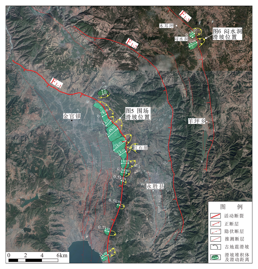
Fig.4 Paleoseismic landslide distribution in the Jinguan area

Fig.5 The Weichang paleoseismic landslide

Fig.6 The Menshuidong paleoseismic landslide
| 样品编号 | 238U含量/ 10-6 | 232Th含量/ 10-9 | (230Th /232Th)/ 10-6 | *δ234U (测量值) | 230Th/238U | **234Uinitial (校正) | 校正年龄/a BP |
|---|---|---|---|---|---|---|---|
| 140803-1 | 121±0 | 13 568±272 | 123.4±2.5 | 12.5±2.2 | 0.840 2±0.002 0 | 21±3 | 188 327±2 928 |
| 140803-2 | 1 129±4 | 15 087±305 | 868.1±17.9 | 920.3±5.1 | 0.703 3±0.003 7 | 1 053±3 | 47 583±369 |
| 140803-3 | 83±0 | 15 618±313 | 52.7±1.1 | 27.7±3.8 | 0.603 7±0.003 0 | 36±5 | 90 532±3 959 |
Table 3 Uranium series ages of samples from the Menshuidong paleoseismic landslide deposit
| 样品编号 | 238U含量/ 10-6 | 232Th含量/ 10-9 | (230Th /232Th)/ 10-6 | *δ234U (测量值) | 230Th/238U | **234Uinitial (校正) | 校正年龄/a BP |
|---|---|---|---|---|---|---|---|
| 140803-1 | 121±0 | 13 568±272 | 123.4±2.5 | 12.5±2.2 | 0.840 2±0.002 0 | 21±3 | 188 327±2 928 |
| 140803-2 | 1 129±4 | 15 087±305 | 868.1±17.9 | 920.3±5.1 | 0.703 3±0.003 7 | 1 053±3 | 47 583±369 |
| 140803-3 | 83±0 | 15 618±313 | 52.7±1.1 | 27.7±3.8 | 0.603 7±0.003 0 | 36±5 | 90 532±3 959 |
| 断裂带分段 | 断裂名称 | 断裂编号 | 垂向速率 /(mm·a-1) | 水平速率 /(mm·a-1) | 震级 | 岩性 | 古地震滑坡数 | ||
|---|---|---|---|---|---|---|---|---|---|
| 大型 | 巨型 | ||||||||
| 永胜—金官段 | 金官断裂 | | 0.20~0.22 | M 7 ¾ | 硬质岩为主 | 10 | 14 | ||
| 永胜断裂 | | 0.16~0.17 | |||||||
| 木耳坪—羊坪断裂 | | 0.08~0.10 | |||||||
| 程海段 | |||||||||
| 程海断裂 | | 0.34~0.40 | |||||||
| 海中断裂 | | 0.12~0.16 | |||||||
| 期纳段 | 期纳断裂 | | 0.30~0.32 | M 5.4 M 5.1 M 6.0 | 硬质岩为主 | 11 | 10 | ||
| 金江断裂 | | 0.34~0.36 | 1.0~1.2 | ||||||
| 宾川段 | 宾川断裂 | | 0.30~0.34 | M 6.3 M 5.5 M 5.0 | 较软岩-软岩为主 | 10 | 0 | ||
| 上沧—鱼棚断裂 | | 0.16 | 0.50 | ||||||
| 毛栗坡段 | 毛栗坡断裂 | F5 | 0.08 | 0.30 | M 6.3 M 7.0 M 5.0 | 北部硬质岩,南部 较软岩-软岩 | 15 | 0 | |
| 弥渡段 | 弥渡断裂 | F6-1 | 0.28~0.32 | ||||||
Table 4 Statistical table of activity parameters and paleoseismic landslide events for each segment of the fault zone
| 断裂带分段 | 断裂名称 | 断裂编号 | 垂向速率 /(mm·a-1) | 水平速率 /(mm·a-1) | 震级 | 岩性 | 古地震滑坡数 | ||
|---|---|---|---|---|---|---|---|---|---|
| 大型 | 巨型 | ||||||||
| 永胜—金官段 | 金官断裂 | | 0.20~0.22 | M 7 ¾ | 硬质岩为主 | 10 | 14 | ||
| 永胜断裂 | | 0.16~0.17 | |||||||
| 木耳坪—羊坪断裂 | | 0.08~0.10 | |||||||
| 程海段 | |||||||||
| 程海断裂 | | 0.34~0.40 | |||||||
| 海中断裂 | | 0.12~0.16 | |||||||
| 期纳段 | 期纳断裂 | | 0.30~0.32 | M 5.4 M 5.1 M 6.0 | 硬质岩为主 | 11 | 10 | ||
| 金江断裂 | | 0.34~0.36 | 1.0~1.2 | ||||||
| 宾川段 | 宾川断裂 | | 0.30~0.34 | M 6.3 M 5.5 M 5.0 | 较软岩-软岩为主 | 10 | 0 | ||
| 上沧—鱼棚断裂 | | 0.16 | 0.50 | ||||||
| 毛栗坡段 | 毛栗坡断裂 | F5 | 0.08 | 0.30 | M 6.3 M 7.0 M 5.0 | 北部硬质岩,南部 较软岩-软岩 | 15 | 0 | |
| 弥渡段 | 弥渡断裂 | F6-1 | 0.28~0.32 | ||||||

Fig.7 Genetic mechanism of rotational deformation in the Northwest Yunnan fault depression zone. Modified after [30].
| [1] |
KEEFER D K. Landslides caused by earthquakes[J]. Geological Society of America Bulletin, 1984,95(4):406-421.
DOI URL |
| [2] | 黄润秋. 汶川8.0级地震触发崩滑灾害机制及其地质力学模式[J]. 岩石力学与工程学报, 2009,28(6):1239-1249. |
| [3] | 许冲, 戴福初, 陈剑, 等. 汶川MS 8.0地震重灾区次生地质灾害遥感精细解译[J]. 遥感学报, 2009,13(4):745-762. |
| [4] | 殷跃平. 汶川八级地震地质灾害研究[J]. 工程地质学报, 2008,16(4):433-444. |
| [5] |
KEEFER D K. Statistical analysis of an earthquake-induced landslide distribution: the 1989 LomaPrieta, California event[J]. Engineering Geology, 2000,58(3/4):231-249.
DOI URL |
| [6] |
PAPADOPOULOS G A, PLESSA A. Magnitude-distance relations for earthquake-induced landslides in Greece[J]. Engineering Geology, 2000,58(3/4):377-386.
DOI URL |
| [7] | 黄润秋, 李为乐. “5.12”汶川大地震触发地质灾害的发育分布规律研究[J]. 岩石力学与工程学报, 2009,27(12):2585-2592. |
| [8] | 丁彦慧, 王余庆, 孙进忠. 地震崩滑与地震参数的关系及其在边坡震害预测中的应用[J]. 地球物理学报, 1999,42(增刊):101-107. |
| [9] | 许冲, 戴福初, 徐锡伟. 汶川地震滑坡灾害研究综述[J]. 地质论评, 2010,56(6):860-874. |
| [10] | 李为乐, 伍霁, 吕宝雄. 地震滑坡研究回顾与展望[J]. 灾害学, 2011,26(3):103-108. |
| [11] | 张铎, 吴中海, 李家存, 等. 国内外地震滑坡研究综述[J]. 地质力学学报, 2013,19(3):225-241. |
| [12] | ÇELEBI M. Topographical and geological amplifications determined from strong-motion and aftershock records of the 3 March 1985 Chile earthquake[J]. Bulletin of the Seismological Society of America, 1987,77(4):1141-1147. |
| [13] | 方华, 崔鹏. 汶川地震大型高速远程滑坡力学机理及控制因子分析[J]. 灾害学, 2010,25(增刊):120-126, 130. |
| [14] | 许强, 董秀军. 汶川地震大型滑坡成因模式[J]. 地球科学: 中国地质大学学报, 2011(6):172-180. |
| [15] | 黄润秋, 裴向军, 李天斌. 汶川地震触发大光包巨型滑坡基本特征及形成机理分析[J]. 工程地质学报, 2008,16(6):730-741. |
| [16] | 毛彦龙, 胡广韬, 毛新虎, 等. 地震滑坡启程剧动的机理研究及离散元模拟[J]. 工程地质学报, 2001,9(1):74-80. |
| [17] | 许强, 黄润秋. 5.12汶川大地震诱发大型崩滑灾害动力特征初探[J]. 工程地质学报, 2008,16(6):721-729. |
| [18] | 殷跃平. 汶川八级地震滑坡特征分析[J]. 工程地质学报, 2009,17(1):29-38. |
| [19] |
ALLEN C R, GILLESPIE A R, YUAN H, et al. Red river and associated faults, Yunnan province, China: quaternary geology, slip rates, and seismic hazard[J]. Geological Society of America Bulletin, 1984,95(6):686-700.
DOI URL |
| [20] | 虢顺民, 向宏发, 计凤桔, 等. 红河断裂带第四纪右旋走滑与尾端拉张转换关系研究[J]. 地震地质, 1996,18(4):301-309. |
| [21] |
TAPPONNIER P, PELTZER G, ARMIJO R. On the mechanics of the collision between India and Asia[J]. Geological Society, London, Special Publications, 1986,19(1):113-157.
DOI URL |
| [22] | WANG E, BURCHFIEL B C, ROYDEN L H, et al. Late Cenozoic Xianshuihe-Xiaojiang Red river, and Dali fault systems of south-western Sichuan and central Yunnan, China[M]. McLean: Geological Society of America, 1998: 1-108. |
| [23] | 黄小巾, 吴中海, 李家存, 等. 滇西北裂陷带的构造地貌特征与第四纪构造活动性[J]. 地质通报, 2014,33(4):578-593. |
| [24] | 郭长宝, 雷伟志, 张永双, 等. 滇藏铁路滇西北段主要地质灾害类型及发育规律的探讨[J]. 地质力学学报, 2006,12(2):228-235. |
| [25] | 国家地震局地质研究所, 云南省地震局. 滇西北地区活动断裂[M]. 北京: 地震出版社, 1990. |
| [26] | 李光容, 金德山. 程海断裂带挽近期活动性研究[J]. 云南地质, 1990,9(1):1-24. |
| [27] | 虢顺民, 向宏发, 张靖, 等. 1515年云南永胜地震形变带和震级讨论[J]. 地震研究, 1988,11(2):153-162. |
| [28] |
CHUN F, WANG G, WANG S F, et al. Structural interpretation of extensional deformation along the Dali fault system, southeastern margin of the Tibetan Plateau[J]. International Geology Review, 2006,48(4):287-310.
DOI URL |
| [29] | 罗睿洁, 吴中海, 黄小龙, 等. 滇西北宾川地区主要活动断裂及其活动构造体系[J]. 地质通报, 2015,34(1):155-170. |
| [30] | 黄小龙, 吴中海, 吴坤罡, 等. 滇西北永胜地区主要活动断裂与活动构造体系[J]. 地质力学学报, 2016,22(3):531-547. |
| [31] | 毛玉平. 云南地区强震(M≥6级)研究[M]. 昆明: 云南科技出版社, 2003: 1-302. |
| [32] | 俞维贤, 张建国, 周光全, 等. 2001年永胜6级地震的地表破裂与程海断裂[J]. 地震研究, 2005,28(2):125-128. |
| [33] |
HUANG X L, WU Z H, WU K G. Surface rupture of the 1515 Yongsheng earthquake in northwest Yunnan, and its seismogeological implications[J]. Acta Geologica Sinica (English Edition), 2018,92(4):1324-1333.
DOI URL |
| [34] | 张铎, 吴中海, 李家存, 等. 滇西北永胜—宾川地区滑坡发育的影响因子分析及其动力成因与意义探讨[J]. 自然灾害学报, 2016,25(1):176-190. |
| [35] | 杜泽, 王品, 官琦. 程海断裂带金沙江段滑坡群的发现[J]. 科学技术与工程, 2012,12(33):8815-8821, 8825. |
| [36] | 李乾坤, 徐则民, 张家明. 永胜金沙江寨子村古滑坡和古堰塞湖的发现[J]. 山地学报, 2011,29(6):729-737. |
| [37] | 徐则民. 金沙江寨子村滑坡坝堰塞湖沉积及其对昔格达组地层成因的启示[J]. 地质论评, 2011,57(5):675-686. |
| [38] | 徐则民, 刘文连, 黄润秋. 金沙江寨子村巨型古滑坡的工程地质特征及其发生机制[J]. 岩石力学与工程学报, 2011,30(增刊2):3539-3550. |
| [39] | 张家明, 徐则民, 李乾坤, 等. 永胜金沙江寨子村古滑坡的新发现及地质构造约束[J]. 吉林大学学报(地球科学版), 2012,42(增刊3):206-213. |
| [40] |
ALLEN C R, LUO Z L, HONG Q, et al. Field study of a highly active fault zone: the Xianshuihe fault of southwestern China[J]. Geological Society of America Bulletin, 1991,103(9):1178-1199.
DOI URL |
| [41] |
LELOUP P H, LACASSIN R, TAPPONNIER P, et al. The Ailao Shan-Red river shear zone (Yunnan, China), Tertiary transform boundary of Indochina[J]. Tectonophysics, 1995,251(1/2/3/4):3-84.
DOI URL |
| [42] |
WANG E, BURCHFIEL B C. Interpretation of Cenozoic tectonics in the right-lateral accommodation zone between the Ailao Shan shear zone and the eastern Himalayan syntaxis[J]. International Geology Review, 1997,39(3):191-219.
DOI URL |
| [43] | 刘光勋, 李方全, 李桂荣. 我国滇西北地震活动区的活动构造与应力状态[J]. 地震地质, 1986,8(1):1-14. |
| [44] | 国家地震局地质研究所. 现代地壳运动研究(1): 大陆裂谷与深部过程[M]. 北京: 地震出版社, 1985: 118-132. |
| [45] | 吴中海, 张永双, 胡道功, 等. 滇西北哈巴—玉龙雪山东麓断裂的晚第四纪正断层作用及其动力学机制探讨[J]. 中国科学: D辑, 2008,38(11):1361-1375. |
| [46] | 徐锡伟, 闻学泽, 郑荣章, 等. 川滇地区活动块体最新构造变动样式及其动力来源[J]. 中国科学: D辑, 2003,33(增刊):151-162. |
| [47] |
CUI X, XIE F R, ZHANG H Y. Recent tectonic stress field zoning in Sichuan-Yunnan region and its dynamic interest[J]. Acta Seismologica Sinica, 2006,19(5):485-496.
DOI URL |
| [48] | 钱晓东, 秦嘉政, 刘丽芳. 云南地区现代构造应力场研究[J]. 地震地质, 2011,33(1):91-106. |
| [49] | 中华人民共和国水利部. GB50218—2014 工程岩体分级标准[S]. 北京: 中国计划出版社, 2014. |
| [50] | 黄小巾, 吴中海, 黄小龙, 等. 滇西北程海—宾川断裂带第四纪分段活动性的构造地貌表现与限定[J]. 地球科学, 2018,43(12):4651-4670. |
| [51] | 陈文寄, HARRISON T M, LOVERA O M. 哀牢山—红河剪切带的热年代学研究: 多重扩散域模式的应用实例[J]. 地震地质, 1992,14(2):121-128. |
| [52] | LELOUP P H, HARRISON T M, RYERSON F J, et al. Structural, petrological and thermal evolution of a Tertiary ductile strike-slip shear zone, Diancang Shan, Yunnan[J]. Journal of Geophysical Research: Solid Earth, 1993,98(B4):6715-6743. |
| [53] | 云南省地质矿产局. 云南省区域地质志[M]. 北京: 地质出版社, 1990. |
| [54] |
CLARK M K, ROYDEN L H, WHIPPLE K X, et al. Use of a regional, relict landscape to measure vertical deformation of the eastern Tibetan Plateau[J]. Journal of Geophysical Research: Earth Surface, 2006,111(F3). DOI: 10.1029/2005JF000294.
DOI |
| [55] | 王二七, 樊春, 王刚, 等. 滇西哀牢山—点苍山形成的构造和地貌过程[J]. 第四纪研究, 2006,26(2):220-227. |
| [56] | 崔之久, 高全洲, 刘耕年, 等. 青藏高原夷平面与岩溶时代及其起始高度[J]. 科学通报, 1996,41(15):1402-1406. |
| [57] | 国家地震局震害防御司. 中国历史强震目录: 公元前23世纪—公元1911年[M]. 北京: 地震出版社, 1995. |
| [58] | 吴树仁, 石菊松, 姚鑫, 等. 四川汶川地震地质灾害活动强度分析评价[J]. 地质通报, 2008,27(11):1900-1906. |
| [59] | 许冲, 徐锡伟, 吴熙彦, 等. 2008年汶川地震滑坡详细编目及其空间分布规律分析[J]. 工程地质学报, 2013,21(1):25-44. |
| [60] | 许冲, 徐锡伟, 于贵华. 玉树地震滑坡分布调查及其特征与形成机制[J]. 地震地质, 2012,34(1):47-62. |
| [61] | 蒋瑶, 吴中海, 李家存, 等. 2010年玉树7.1级地震诱发滑坡特征及其地震地质意义[J]. 地质学报, 2014,88(6):1157-1176. |
| [62] | 郭乾, 李渝生, 黄青松, 等. 则木河断裂带古地震滑坡研究[J]. 灾害学, 2014,29(2):182-187. |
| [63] | 石菊松, 吴树仁, 石玲. 遥感在滑坡灾害研究中的应用进展[J]. 地质论评, 2008,54(4):505-514, 579. |
| [64] | 周本刚, 张裕明. 中国西南地区地震滑坡的基本特征[J]. 西北地震学报, 1994,16(1):95-103. |
| [65] | 袁进科, 裴向军. 汶川地震震裂山体裂缝变形特征与动力机制研究[J]. 防灾减灾工程学报, 2015,35(6):848-855. |
| [66] |
WU Z H, ZHANG Y S, HU D G, et al. Late Quaternary normal faulting and its kinematic mechanism of eastern piedmont fault of the Haba-Yulong Snow Mountains in northwestern Yunnan, China[J]. Science in China: Earth Sciences, 2009,52(10):1470-1484.
DOI URL |
| [67] |
LI S H, DENG C L, YAO H T, et al. Magnetostratigraphy of the Dali basin in Yunnan and implications for late Neogene rotation of the southeast margin of the Tibetan Plateau[J]. Journal of Geophysical Research: Solid Earth, 2013,118(3):791-807.
DOI URL |
| [68] | 吴中海, 龙长兴, 范桃园, 等. 青藏高原东南缘弧形旋扭活动构造体系及其动力学特征与机制[J]. 地质通报, 2015,34(1):1-31. |
| [69] |
SHI X, WANG Y, SIEH K E, et al. Fault slip and GPS velocities across the Shan Plateau define a curved southwestward crustal motion around the eastern Himalayan syntaxis[J]. Journal of Geophysical Research: Solid Earth, 2018,123(3):2502-2518.
DOI URL |
| [1] | SHANGGUAN Shuantong, TIAN Lanlan, PAN Miaomiao, YANG Fengliang, YUE Gaofan, SU Ye, QI Xiaofei. Fault slip tendency and induced-earthquake risks in hot dry rock development: A case study in the Tangshan Matouying HDR site [J]. Earth Science Frontiers, 2024, 31(6): 252-260. |
| [2] | ZHOU Wei, MA Xiao, CHEN Wenyi, GAO Rui, WANG Yan, HU Dawei. Carbonates of the Wumishan Formation, Jixian System in the North China Plain: Mechanical properties under in-situ geothermal conditions [J]. Earth Science Frontiers, 2024, 31(6): 95-103. |
| [3] | HUANG Siyu, PU Junbing, PAN Moucheng, LI Jianhong, ZHANG Tao. Effects of algae-derived organic matter source on sediment mineralization in the karst reservoir [J]. Earth Science Frontiers, 2024, 31(5): 387-396. |
| [4] | YANG Huaju, LI Canfeng, YANG Kehao, ZHANG Xilu, WANG Chuanyu, WANG Xingrong, HE Xu, PENG Xuefeng, ZHANG Liankai. Biomass and distribution characteristics of dominant shrubs under varying degrees of rocky desertification in the karst region of southern Yunnan [J]. Earth Science Frontiers, 2024, 31(5): 440-448. |
| [5] | CHEN Fajia, XIAO Qiong, HU Xiangyun, GUO Yongli, SUN Ping’an, ZHANG Ning. Weathering process and carbon sink effect of carbonates in typical karst small basin [J]. Earth Science Frontiers, 2024, 31(5): 449-459. |
| [6] | LIAO Zhou, LI Mei. Research on the 3D implicit potential field modeling method for urban underground space based on the open-source GemPy [J]. Earth Science Frontiers, 2024, 31(3): 482-497. |
| [7] | LIU Qixin, GU Xingfa, WANG Chunmei, YANG Jian, ZHAN Yulin. Soil moisture retrieval on both active and passive microwave data scales [J]. Earth Science Frontiers, 2024, 31(2): 42-53. |
| [8] | XU Haning, DENG Juzhi, XIAO Hui. Multi-dimensional geoelectrical resistivity imaging monitoring for debris flow based on neighborhood domain features [J]. Earth Science Frontiers, 2023, 30(6): 473-484. |
| [9] | TANG Minggao, LIU Xinxin, LI Guang, ZHAO Huanle, XU Qiang, ZHU Xing, LI Weile. Mechanism of ice avalanche in the Sedongpu sag, Yarlung Zangbo River basin-an experimental study [J]. Earth Science Frontiers, 2023, 30(4): 405-417. |
| [10] | YU Shi, PU Junbing, LIU Fan, YANG Hui. Effect of vegetation on carbon sequestration in karst systems-a critical review [J]. Earth Science Frontiers, 2023, 30(4): 418-428. |
| [11] | SU Dong, HUANG Maolong, HAN Wenlong, LI Aiguo, WANG Enzhi, CHEN Xiangsheng. Suitability evaluation of underground space development in Shenzhen: Urban geoenvironmental considerations [J]. Earth Science Frontiers, 2023, 30(4): 514-524. |
| [12] | CHEN Xuan, LIU Wanghan, BAO Dian, ZHANG Liping, CHEN Lixiong, YANG Min, ZHANG Juan, LI Yingju, LI Guangye, JIA Yufeng. Ordovician palaeokarst caves in the Tahe oilfield: Burial age of cave fills and its implication for hydrocarbon reservoirs [J]. Earth Science Frontiers, 2023, 30(4): 65-75. |
| [13] | XUE Tao, BAO Xunshuan, ZHU Xiaodi, HUANG Xiao. Attribute modeling constrained by multi-source data-based 3D geological structural model: A case study in Tongzhou District, Beijing [J]. Earth Science Frontiers, 2023, 30(3): 529-536. |
| [14] | ZHOU Changsong, ZOU Shengzhang, FENG Qiyan, ZHU Danni, LI Jun, WANG Jia, XIE Hao, DENG Rixin. Progress in hydrogeochemical study of Karst Critical Zone: A critical review [J]. Earth Science Frontiers, 2022, 29(3): 37-50. |
| [15] | LI Gao, TAN Jianmin, WANG Shimei, LIN Xu, CHEN Yong, WANG Li, GUO Fei. Multi-index monitoring and comprehensive early warning of landslides in response to rainfall: An example of the Luo'ao landslide in southern Jiangxi Province [J]. Earth Science Frontiers, 2021, 28(6): 283-294. |
| Viewed | ||||||
|
Full text |
|
|||||
|
Abstract |
|
|||||