Earth Science Frontiers ›› 2024, Vol. 31 ›› Issue (3): 482-497.DOI: 10.13745/j.esf.sf.2024.2.30
Previous Articles Next Articles
LIAO Zhou( ), LI Mei*()
Received:2024-01-05
Revised:2024-03-25
Online:2024-05-25
Published:2024-05-25
CLC Number:
LIAO Zhou, LI Mei. Research on the 3D implicit potential field modeling method for urban underground space based on the open-source GemPy[J]. Earth Science Frontiers, 2024, 31(3): 482-497.

Fig.1 Overall workflow
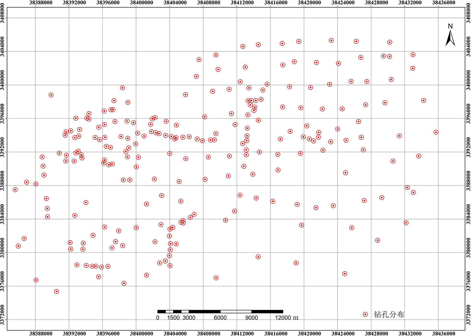
Fig.2 Distribution of borehole locations in the study area
| 地层单位 | 地层划分 | 岩性简述 | |||||
|---|---|---|---|---|---|---|---|
| 系 | 统 | 阶 | 段 | ||||
| 第 四 系 | 全 新 统 | 上阶 | SA1_0 | 杂填土、素填土 吹填土、淤填土 | |||
| SA1_1 | SA1_2 | 褐黄、灰黄粉质黏土、黏土 | 黄褐色、灰褐色粉土 | ||||
| 中阶 | SA2 | 灰色淤泥质土,黄灰、灰色粉土、粉砂 | |||||
| 下阶 | SA3_0 | 褐黄色黏土、粉质黏土,局部灰黄色粉细砂 | |||||
| SA3 | 灰色淤泥质土、灰色黏性土 | ||||||
| 上 更 新 统 | 上阶 | 上段 | SA4_1 | 褐黄、灰绿色黏性土,局部灰黄色粉细砂 | |||
| SA4_2 | 灰色黏性土,局部灰绿色粉土(第三软弱层) | ||||||
| SA4_3 | 灰、灰黄色粉土、粉细砂 | ||||||
| 下段 | SA5_1 | 褐黄、灰绿色黏性土 | |||||
| SA5_2 | 灰色黏性土 | ||||||
| SA5_3 | 灰、灰黄、灰绿色粉土、粉砂、砂,局部含砾 | ||||||
| 下阶 | SA6_1 | 褐黄、灰绿色黏性土 | |||||
| SA6_3_4 | 灰、灰黄卵(砾石)、砾砂、砂 | ||||||
| 中 更 新 统 | 上阶 | SA7_1 | 杂色黏性土层 | ||||
| SA7_2 | 卵(砾石)、砾砂、砂 | ||||||
| 下阶 | SA8_1 | 杂色黏性土层,局部含砾 | |||||
| 前第 四系 | SA10 | 不同时代不同类型岩石 | |||||
Table 1 Table of information related to the stratigraphy of the study area
| 地层单位 | 地层划分 | 岩性简述 | |||||
|---|---|---|---|---|---|---|---|
| 系 | 统 | 阶 | 段 | ||||
| 第 四 系 | 全 新 统 | 上阶 | SA1_0 | 杂填土、素填土 吹填土、淤填土 | |||
| SA1_1 | SA1_2 | 褐黄、灰黄粉质黏土、黏土 | 黄褐色、灰褐色粉土 | ||||
| 中阶 | SA2 | 灰色淤泥质土,黄灰、灰色粉土、粉砂 | |||||
| 下阶 | SA3_0 | 褐黄色黏土、粉质黏土,局部灰黄色粉细砂 | |||||
| SA3 | 灰色淤泥质土、灰色黏性土 | ||||||
| 上 更 新 统 | 上阶 | 上段 | SA4_1 | 褐黄、灰绿色黏性土,局部灰黄色粉细砂 | |||
| SA4_2 | 灰色黏性土,局部灰绿色粉土(第三软弱层) | ||||||
| SA4_3 | 灰、灰黄色粉土、粉细砂 | ||||||
| 下段 | SA5_1 | 褐黄、灰绿色黏性土 | |||||
| SA5_2 | 灰色黏性土 | ||||||
| SA5_3 | 灰、灰黄、灰绿色粉土、粉砂、砂,局部含砾 | ||||||
| 下阶 | SA6_1 | 褐黄、灰绿色黏性土 | |||||
| SA6_3_4 | 灰、灰黄卵(砾石)、砾砂、砂 | ||||||
| 中 更 新 统 | 上阶 | SA7_1 | 杂色黏性土层 | ||||
| SA7_2 | 卵(砾石)、砾砂、砂 | ||||||
| 下阶 | SA8_1 | 杂色黏性土层,局部含砾 | |||||
| 前第 四系 | SA10 | 不同时代不同类型岩石 | |||||

Fig.3 Schematic cross-section of shallow hole depth control pretreatment
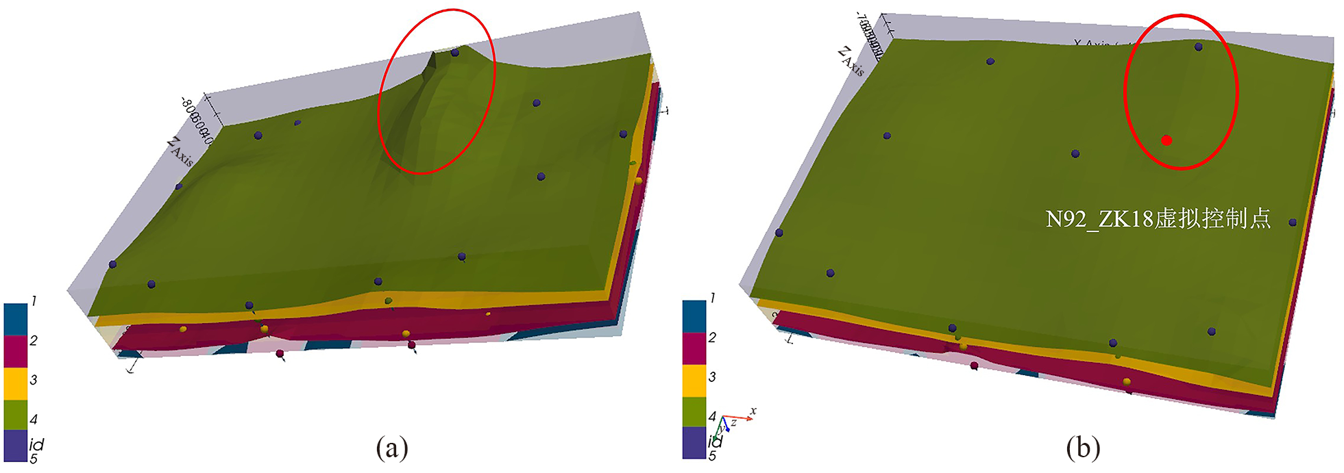
Fig.4 Shallow hole depth control preprocessing of modeling datasets (a) The abnormality of shallow hole depth control appears in the model; (b) the processing effect of Deep Surface.

Fig.5 Modeling working principles

Fig.6 Scalar field and its gradient
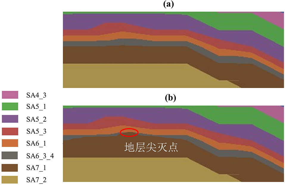
Fig.7 Local model profile of the three-dimensional geological model in the research area (a) Before strata pinching treatment; (b) After strata pinching treatment.

Fig.8 Two-dimensional visualization results of the research area modeling data set (a) x-axis direction; (b) y-axis direction.

Fig.9 Three-dimensional spatial distribution of modeling data set in the study area

Fig.10 Three-dimensional geological model results of the study area, visualized from different perspectives (a) isometric view; (b)-z;(c)+z;(d)-y;(e)+y;(f)-x;(g)+x

Fig.11 Three-dimensional geological model of the study area (a) Model geological interface set (stretch exaggeration coefficient=2); (b) Wireframe mode.

Fig.12 Visualization results of each stratigraphic layer of the three-dimensional geological model of the study area

Fig.13 Overall view and other views under different conditions (a) Volume element size: 100×80×80, grid number=64000; (b) Volume element size: 50×40×30, grid number=60000.

Fig.14 Depth map of each layer in the three-dimensional geological model of the study area (a)SA0; (b)SA1_1; (c) SA1_2; (d) SA2
| 地层 | 精度指标(值域) | |||
|---|---|---|---|---|
| CC [-1,1] | RMSE (0,+∞) | bias (-∞,0)∪ [0,+∞) | MAE (0,+∞) | |
| SA0 | 0.898 293 | 3.477 853 651 | -0.568 945 | 0.006 677 825 4 |
| SA1_1 | 0.808 163 | 3.868 290 178 | -0.734 876 | 0.008 604 348 6 |
| SA1_2 | 0.790 859 | 4.373 820 489 | -10.763 290 | 0.009 982 961 3 |
| SA2 | 0.729 982 | 4.918 728 856 | -11.793 872 | 0.011 946 271 0 |
| SA3 | 0.657 102 | 5.972 010 837 | -13.802 891 | 0.013 985 019 8 |
| SA3_0 | 0.650 391 | 6.108 289 082 | -14.082 647 | 0.014 074 550 1 |
| SA4_1 | 0.550 829 | 9.289 107 576 | 16.290 184 | 0.028 476 845 3 |
| SA4_2 | 0.550 021 | 9.587 408 083 | 17.208 371 | 0.029 081 209 7 |
| SA4_3 | 0.548 902 | 9.718 018 476 | 17.937 659 | 0.030 128 748 9 |
| SA5_1 | 0.530 827 | 10.278 377 632 | 18.628 746 | 0.039 475 665 1 |
| SA5_2 | 0.553 805 | 9.037 486 502 | 16.750 385 | 0.028 947 630 6 |
| SA5_3 | 0.529 104 | 10.910 471 291 | 19.056 821 | 0.040 129 479 5 |
| SA6_1 | 0.528 576 | 10.983 465 825 | 19.856 625 | 0.040 146 286 4 |
| SA6_3_4 | 0.519 865 | 11.746 208 264 | 20.047 652 | 0.041 846 567 2 |
| SA7_1 | -0.504 872 | 11.896 773 621 | 20.103 867 | 0.053 857 309 1 |
| SA7_2 | -0.504 635 | 11.907 857 693 | 20.859 261 | 0.062 947 565 8 |
| SA8_1 | 0.503 748 3 | 13.294 876 507 | 21.907 703 | 0.082 056 328 2 |
| SA10 | 0.502 837 6 | 16.205 873 628 | 23.287 659 | 0.094 859 287 5 |
Table 2 Accuracy verification of the three-dimensional geological model of the study area
| 地层 | 精度指标(值域) | |||
|---|---|---|---|---|
| CC [-1,1] | RMSE (0,+∞) | bias (-∞,0)∪ [0,+∞) | MAE (0,+∞) | |
| SA0 | 0.898 293 | 3.477 853 651 | -0.568 945 | 0.006 677 825 4 |
| SA1_1 | 0.808 163 | 3.868 290 178 | -0.734 876 | 0.008 604 348 6 |
| SA1_2 | 0.790 859 | 4.373 820 489 | -10.763 290 | 0.009 982 961 3 |
| SA2 | 0.729 982 | 4.918 728 856 | -11.793 872 | 0.011 946 271 0 |
| SA3 | 0.657 102 | 5.972 010 837 | -13.802 891 | 0.013 985 019 8 |
| SA3_0 | 0.650 391 | 6.108 289 082 | -14.082 647 | 0.014 074 550 1 |
| SA4_1 | 0.550 829 | 9.289 107 576 | 16.290 184 | 0.028 476 845 3 |
| SA4_2 | 0.550 021 | 9.587 408 083 | 17.208 371 | 0.029 081 209 7 |
| SA4_3 | 0.548 902 | 9.718 018 476 | 17.937 659 | 0.030 128 748 9 |
| SA5_1 | 0.530 827 | 10.278 377 632 | 18.628 746 | 0.039 475 665 1 |
| SA5_2 | 0.553 805 | 9.037 486 502 | 16.750 385 | 0.028 947 630 6 |
| SA5_3 | 0.529 104 | 10.910 471 291 | 19.056 821 | 0.040 129 479 5 |
| SA6_1 | 0.528 576 | 10.983 465 825 | 19.856 625 | 0.040 146 286 4 |
| SA6_3_4 | 0.519 865 | 11.746 208 264 | 20.047 652 | 0.041 846 567 2 |
| SA7_1 | -0.504 872 | 11.896 773 621 | 20.103 867 | 0.053 857 309 1 |
| SA7_2 | -0.504 635 | 11.907 857 693 | 20.859 261 | 0.062 947 565 8 |
| SA8_1 | 0.503 748 3 | 13.294 876 507 | 21.907 703 | 0.082 056 328 2 |
| SA10 | 0.502 837 6 | 16.205 873 628 | 23.287 659 | 0.094 859 287 5 |
| [1] | ELMQVIST T, ANDERSSON E, MCPHEARSON T, et al. Urbanization in and for the Anthropocene[J]. Urban Sustainability, 2021, 1(1): 6. |
| [2] | 郝卉. 城市地下空间发展现状与前景[J]. 砖瓦, 2021(11): 85-86. |
| [3] | XIE H, ZHANG Y, CHEN Y, et al. A case study of development and utilization of urban underground space in Shenzhen and the Guangdong-Hong Kong-Macao Greater Bay Area[J]. Tunnelling and Underground Space Technology, 2021, 107: 103651. |
| [4] | OSWALD C, RINNER C, ROBINSON A. Applications of 3D printing in physical geography education and urban visualization[J]. Cartographica: The International Journal for Geographic Information and Geovisualization, 2019, 54(4): 278-287. |
| [5] | OLIEROOK H K H, SCALZO R, KOHN D, et al. Bayesian geological and geophysical data fusion for the construction and uncertainty quantification of 3D geological models[J]. Geoscience Frontiers, 2021, 12(1): 479-493. |
| [6] | 田玉培, 王俊, 刘文文. 城市地下空间三维地质建模的研究及实现[J]. 现代矿业, 2021, 37(8): 49-52, 55. |
| [7] | JING H, HANHAN H, GUISEN Z, et al. 3D geological modelling of superficial deposits in Beijing City[J]. Geology in China, 2019, 46(2): 244-254. |
| [8] | BIRCH C. New systems for geological modelling-black box or best practice?[J]. Journal of the Southern African Institute of Mining and Metallurgy, 2014, 114(12): 993-1000. |
| [9] | COWAN E J, BEATSON R K, FRIGHT W R, et al. Rapid geological modelling[C]//Applied structural geology for mineral exploration and mining, international symposium, Kalgoorlie, Australia: Kalgoorlie. 2002, 9: 23-25. |
| [10] | COWAN E J, BEATSON R K, ROSS H J, et al. Practical implicit geological modelling[C]//Proceedings of the 5th international mining geology conference. Bendigoe: Australasian Institute of Mining and Metallurgy Melbourne, 2003, 8: 89-99. |
| [11] | VOLLGGER S A, CRUDEN A R, AILLERES L, et al. Regional dome evolution and its control on ore-grade distribution: insights from 3D implicit modelling of the Navachab gold deposit, Namibia[J]. Ore Geology Reviews, 2015, 69: 268-284. |
| [12] | VON HARTEN J, DE LA VARGA M, HILLIER M, et al. Informed local smoothing in 3D implicit geological modeling[J]. Minerals, 2021, 11(11): 1281. |
| [13] | 王权, 邹艳红. 基于轮廓线层间形态插值的三维地质隐式曲面重构[J]. 地质科技通报, 2023, 42(5): 293-300. |
| [14] | 王权. 三维地质隐式建模形态不确定性分析与定量评价研究[D]. 长沙: 中南大学, 2022. |
| [15] |
ZHONG D, WANG L, LIN B I, et al. Implicit modeling of complex orebody with constraints of geological rules[J]. Transactions of Nonferrous Metals Society of China, 2019, 29(11): 2392-2399.
DOI |
| [16] | FRANK T, TERTOIS A L, MALLET J L. 3D-reconstruction of complex geological interfaces from irregularly distributed and noisy point data[J]. Computers & Geosciences, 2007, 33(7): 932-943. |
| [17] | CUOMO S, GALLETTI A, GIUNTA G, et al. Reconstruction of implicit curves and surfaces via RBF interpolation[J]. Applied Numerical Mathematics, 2017, 116: 157-171. |
| [18] | SKALA V. RBF interpolation with CSRBF of large data sets[J]. Procedia Computer Science, 2017, 108: 2433-2437. |
| [19] | MACÊDO I, GOIS J P, VELHO L. Hermite radial basis function simplicits[C]//Proceedings of computer graphics forum. Oxford: Blackwell Publishing Ltd, 2011, 30(1): 27-42. |
| [20] | GUO J, WU L, ZHOU W, et al. Section-constrained local geological interface dynamic updating method based on the HRBF surface[J]. Journal of Structural Geology, 2018, 107: 64-72. |
| [21] | FLEISHMAN S, COHEN-OR D, SILVA C T. Robust moving least-squares fitting with sharp features[J]. ACM Transactions on Graphics (TOG), 2005, 24(3): 544-552. |
| [22] | CARR J C, BEATSON R K, CHERRIE J B, et al. Reconstruction and representation of 3D objects with radial basis functions[C]//Proceedings of the 28th annual conference on computer graphics and interactive techniques (SIGGRAPH’01). New York: Association for Computing Machinery, 2001: 67-76. |
| [23] | STOCH B, ANTHONISSEN C J, MCCALL M J, et al. 3D implicit modeling of the Sishen Mine: new resolution of the geometry and origin of Fe mineralization[J]. Mineralium Deposita, 2018, 53(6): 835-853. |
| [24] | JONES M W, CHEN M. A new approach to the construction of surfaces from contour data[C]//Proceedings of computer graphics forum. Edinburgh: Blackwell Science Ltd, 1994, 13(3): 75-84. |
| [25] | 曹勇, 苏晓慧, 孙梦梦, 等. 开源建模软件在水利工程BIM领域中的应用[J]. 水利规划与设计, 2021(8): 96-101, 126. |
| [26] | 张志武. 三维矢量数据矿山模型算法研究及在Blender中的应用[D]. 武汉: 武汉科技大学, 2016. |
| [27] | 赵勇, 许国, 卢鹏, 等. 基于GemPy的隐式三维地质建模方法[J]. 人民长江, 2023, 54(10): 98-104. |
| [28] | WU J, SUN B. Discontinuous mechanical analysis of manifold element strain of rock slope based on open source Gempy[C]//E3S Web of conferences. Hangzhou: EDP Sciences, 2021, 248: 03084. |
| [29] | BEN-SHABAT Y, GOULD S. DeepFit: 3D surface fitting via neural network weighted least squares[C]//Computer Vision-ECCV 2020: 16th European conference. Glasgow: Springer International Publishing, 2020: 20-34. |
| [30] | SCHAAF A, VARGA M, WELLMANN F, et al. Constraining stochastic 3-D structural geological models with topology information using approximate Bayesian computation in GemPy 2.1[J]. Geoscientific Model Development, 2021, 14(6): 3899-3913. |
| [31] | DE LA VARGA M, SCHAAF A, WELLMANN F. GemPy 1.0: open-source stochastic geological modeling and inversion[J]. Geoscience Model Development, 2019, 12 (32): 1-32. |
| [32] | CHEN G, ZHU J, QIANG M, et al. Three-dimensional site characterization with borehole data: a case study of Suzhou area[J]. Engineering Geology, 2018, 234: 65-82. |
| [33] | FISCHER M, PROPPE C. Enhanced universal kriging for transformed input parameter spaces[J]. Probabilistic Engineering Mechanics, 2023, 74: 103486. |
| [34] |
熊前进, 柴小婷, 万翔, 等. 对数泛克立格法在东天山土屋—延东地区Cu、Au异常信息提取中的应用[J]. 资源环境与工程, 2021, 35(4): 536-540.
DOI |
| [35] | LORENSEN W E, CLINE H E. Marching cubes: a high resolution 3D surface construction algorithm[J]. ACM SIGGRAPH Computer Graphics, 1987, 21(4): 163-169. |
| [36] | SANTOLARIA P, VENDEVILLE B C, GRAVELEAU F, et al. Double evaporitic décollements: influence of pinch-out overlapping in experimental thrust wedges[J]. Journal of Structural Geology, 2015, 76: 35-51. |
| [37] |
苏栋, 黄茂隆, 韩文龙, 等. 考虑城市地质环境影响的深圳市地下空间开发适宜性评价[J]. 地学前缘, 2023, 30(4): 514-524.
DOI |
| [38] | 蒋旭, 王婷婷, 穆静. 地下空间开发利用适宜性与资源量的应用研究[J]. 地下空间与工程学报, 2018, 14(5): 1145-1153. |
| [39] | RATA M, DOUAOUI A, LARID M, et al. Comparison of geostatistical interpolation methods to map annual rainfall in the Chéliff watershed, Algeria[J]. Theoretical and Applied Climatology, 2020, 141: 1009-1024. |
| [40] | GUO J, WANG X, WANG J, et al. Three-dimensional geological modeling and spatial analysis from geotechnical borehole data using an implicit surface and marching tetrahedra algorithm[J]. Engineering Geology, 2021, 284: 106047. |
| [41] | BORGHI A, RENARD P, FOURNIER L, et al. Stochastic fracture generation accounting for the stratification orientation in a folded environment based on an implicit geological model[J]. Engineering Geology, 2015, 187: 135-142. |
| [1] | XUE Tao, BAO Xunshuan, ZHU Xiaodi, HUANG Xiao. Attribute modeling constrained by multi-source data-based 3D geological structural model: A case study in Tongzhou District, Beijing [J]. Earth Science Frontiers, 2023, 30(3): 529-536. |
| Viewed | ||||||
|
Full text |
|
|||||
|
Abstract |
|
|||||