Earth Science Frontiers ›› 2021, Vol. 28 ›› Issue (2): 58-70.DOI: 10.13745/j.esf.sf.2020.9.1
Previous Articles Next Articles
LIU Weiming1( ), ZHOU Liqin1,2, CHEN Xiaoqing1,*(), ZHOU Zhen3, Wolfgang SCHWANGHART4, HU Xudong5, LI Xuemei1, ZHANG Xiaogang1
Received:2020-06-30
Revised:2020-09-10
Online:2021-03-25
Published:2021-04-03
Contact:
CHEN Xiaoqing
CLC Number:
LIU Weiming, ZHOU Liqin, CHEN Xiaoqing, ZHOU Zhen, Wolfgang SCHWANGHART, HU Xudong, LI Xuemei, ZHANG Xiaogang. Influence of natural dams on the river profile of the Yalong River Basin[J]. Earth Science Frontiers, 2021, 28(2): 58-70.

Fig.1 Map of the study area

Fig.2 Geomorphological characteristics of the Yalong River Basin. (a) Precipitation distribution map (data from worldclim.org); (b) Steepness index distribution map (topographic data from 30 m STRM DEM); (c) Regional geological map (data from www.ngac.org.cn).

Fig.3 Schematic diagram of knickpoint elevation offset threshold.Modified after [4].
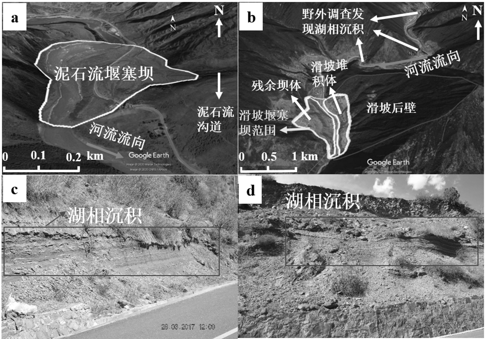
Fig.4 Remote sensing interpretation of dams
| 高程偏移量 阈值/m | 雅砻江流域 总裂点/个 | 雅砻江主干流 裂点/个 | 力丘河主干流 裂点/个 | 其他支流 裂点/个 |
|---|---|---|---|---|
| 30 | 284 | 42 | 7 | 235 |
| 50 | 143 | 20 | 5 | 118 |
| 100 | 49 | 7 | 3 | 39 |
| 200 | 21 | 2 | 2 | 17 |
| 300 | 13 | 0 | 2 | 11 |
Table 1 Extraction of river knickpoints in the Yalong River Basin based on elevation offset threshold
| 高程偏移量 阈值/m | 雅砻江流域 总裂点/个 | 雅砻江主干流 裂点/个 | 力丘河主干流 裂点/个 | 其他支流 裂点/个 |
|---|---|---|---|---|
| 30 | 284 | 42 | 7 | 235 |
| 50 | 143 | 20 | 5 | 118 |
| 100 | 49 | 7 | 3 | 39 |
| 200 | 21 | 2 | 2 | 17 |
| 300 | 13 | 0 | 2 | 11 |
| 堰塞坝编号 | 纬度(N) | 经度(E) | 堰塞坝类型 | 滑坡方量/(104 m3) | 坝高/m | 堰塞坝面积/(104 m2) |
|---|---|---|---|---|---|---|
| 1 | 31°33'1.12″ | 100° 5'15.49″ | 泥石流坝 | 101 | 30.784 1 | |
| 2 | 30°54'15.11″ | 100°16'13.70″ | 泥石流坝 | 66 | 22.769 6 | |
| 3 | 30°40'24.65″ | 100°11'42.45″ | 泥石流坝 | 65 | 64.094 1 | |
| 4 | 30°35'10.42″ | 100°18'17.51″ | 滑坡坝 | 139.80 | 78 | 6.474 2 |
| 5 | 30°33'51.14″ | 100°18'51.38″ | 泥石流坝 | 70 | 27.373 3 | |
| 6 | 30°26'8.77″ | 100°31'39.11″ | 泥石流坝 | 58 | 23.909 7 | |
| 7 | 29°39'0.32″ | 101° 5'28.15″ | 滑坡坝 | 1436.86 | 121 | 33.795 3 |
| 8 | 29°24'42.21″ | 101° 7'44.28″ | 滑坡坝 | 1 916.57 | 168 | 41.455 9 |
| 9 | 29°24'14.76″ | 101° 7'16.66″ | 滑坡坝 | 1 303.98 | 157 | 31.547 7 |
| 10 | 28°26'11.71″ | 101°15'48.76″ | 滑坡坝 | 1 352.19 | 161 | 32.370 4 |
| 11 | 28°22'29.28″ | 101°18'23.60″ | 滑坡坝 | 4 016.52 | 158 | 70.061 |
| 12 | 28°18'51.37″ | 101°21'34.04″ | 滑坡坝 | 3 509.83 | 107 | 63.671 0 |
| 13 | 28°16'59.87″ | 101°22'33.08″ | 滑坡坝 | 9 588.13 | 261 | 129.861 2 |
| 14 | 27°52'4.12″ | 101°23'22.44″ | 滑坡坝 | 2 544.84 | 119 | 50.689 4 |
| 15 | 26°49'54.09″ | 101°45'39.97″ | 滑坡坝 | 16 620.72 | 232 | 191.833 |
| 16 | 29°44'18.84″ | 101°30'47.57″ | 泥石流坝 | 67 | 143.871 5 | |
| 17 | 29°37'8.12″ | 101°21'59.32″ | 滑坡坝 | 8 196.56 | 197 | 116.193 |
| 18 | 29°34'26.27″ | 101°20'46.83″ | 滑坡坝 | 10 229.79 | 258 | 135.966 5 |
| 19 | 29°25'21.52″ | 101°17'29.67″ | 滑坡坝 | 5 542.83 | 189 | 88.040 7 |
| 20 | 30°33'58.77″ | 100° 7'41.00″ | 滑坡坝 | 1 137.345 | 128 | 28.639 8 |
| 21 | 31°20'17.31″ | 100°10'23.95″ | 泥石流坝 | 39 | 21.892 8 | |
| 22 | 30°36'57.68″ | 100°10'59.78″ | 滑坡坝 | 846.42 | 82 | 23.219 7 |
| 23 | 30°33'51.65″ | 100° 0'58.10″ | 泥石流坝 | 89 | 53.939 9 | |
| 24 | 30°25'34.16 | 100° 5'39.77″ | 泥石流坝 | 57 | 27.258 1 | |
| 25 | 28°29'58.50″ | 100°58'59.29″ | 滑坡坝 | 3 083.79 | 170 | 58.087 5 |
| 26 | 28°21'22.76″ | 100°52'38.55″ | 滑坡坝 | 1 024.85 | 117 | 26.593 5 |
| 27 | 27°38'46.09″ | 101°40'36.33″ | 泥石流坝 | 92 | 14.639 3 | |
| 28 | 27°25'22.17″ | 101°43'23.85″ | 泥石流坝 | 90 | 6.201 4 | |
| 29 | 29°32'8.77″ | 101°23'58.48″ | 泥石流坝 | 148 | 49.483 2 | |
| 30 | 27°12'6.38″ | 102°17'9.62″ | 泥石流坝 | 98 | 85.678 8 | |
| 31 | 26°52'22.12″ | 102°17'34.08″ | 泥石流坝 | 41 | 18.313 | |
| 32 | 27°50'5.98″ | 102°24'33.18″ | 泥石流坝 | 76 | 33.188 7 | |
| 33 | 27°56'16.05″ | 102°22'8.59″ | 滑坡坝 | 70.15 | 36 | 3.969 9 |
| 34 | 27°55'30.28″ | 102°23'34.35″ | 滑坡坝 | 123.02 | 68 | 5.912 9 |
Table 2 Statistics of dam types and sizes
| 堰塞坝编号 | 纬度(N) | 经度(E) | 堰塞坝类型 | 滑坡方量/(104 m3) | 坝高/m | 堰塞坝面积/(104 m2) |
|---|---|---|---|---|---|---|
| 1 | 31°33'1.12″ | 100° 5'15.49″ | 泥石流坝 | 101 | 30.784 1 | |
| 2 | 30°54'15.11″ | 100°16'13.70″ | 泥石流坝 | 66 | 22.769 6 | |
| 3 | 30°40'24.65″ | 100°11'42.45″ | 泥石流坝 | 65 | 64.094 1 | |
| 4 | 30°35'10.42″ | 100°18'17.51″ | 滑坡坝 | 139.80 | 78 | 6.474 2 |
| 5 | 30°33'51.14″ | 100°18'51.38″ | 泥石流坝 | 70 | 27.373 3 | |
| 6 | 30°26'8.77″ | 100°31'39.11″ | 泥石流坝 | 58 | 23.909 7 | |
| 7 | 29°39'0.32″ | 101° 5'28.15″ | 滑坡坝 | 1436.86 | 121 | 33.795 3 |
| 8 | 29°24'42.21″ | 101° 7'44.28″ | 滑坡坝 | 1 916.57 | 168 | 41.455 9 |
| 9 | 29°24'14.76″ | 101° 7'16.66″ | 滑坡坝 | 1 303.98 | 157 | 31.547 7 |
| 10 | 28°26'11.71″ | 101°15'48.76″ | 滑坡坝 | 1 352.19 | 161 | 32.370 4 |
| 11 | 28°22'29.28″ | 101°18'23.60″ | 滑坡坝 | 4 016.52 | 158 | 70.061 |
| 12 | 28°18'51.37″ | 101°21'34.04″ | 滑坡坝 | 3 509.83 | 107 | 63.671 0 |
| 13 | 28°16'59.87″ | 101°22'33.08″ | 滑坡坝 | 9 588.13 | 261 | 129.861 2 |
| 14 | 27°52'4.12″ | 101°23'22.44″ | 滑坡坝 | 2 544.84 | 119 | 50.689 4 |
| 15 | 26°49'54.09″ | 101°45'39.97″ | 滑坡坝 | 16 620.72 | 232 | 191.833 |
| 16 | 29°44'18.84″ | 101°30'47.57″ | 泥石流坝 | 67 | 143.871 5 | |
| 17 | 29°37'8.12″ | 101°21'59.32″ | 滑坡坝 | 8 196.56 | 197 | 116.193 |
| 18 | 29°34'26.27″ | 101°20'46.83″ | 滑坡坝 | 10 229.79 | 258 | 135.966 5 |
| 19 | 29°25'21.52″ | 101°17'29.67″ | 滑坡坝 | 5 542.83 | 189 | 88.040 7 |
| 20 | 30°33'58.77″ | 100° 7'41.00″ | 滑坡坝 | 1 137.345 | 128 | 28.639 8 |
| 21 | 31°20'17.31″ | 100°10'23.95″ | 泥石流坝 | 39 | 21.892 8 | |
| 22 | 30°36'57.68″ | 100°10'59.78″ | 滑坡坝 | 846.42 | 82 | 23.219 7 |
| 23 | 30°33'51.65″ | 100° 0'58.10″ | 泥石流坝 | 89 | 53.939 9 | |
| 24 | 30°25'34.16 | 100° 5'39.77″ | 泥石流坝 | 57 | 27.258 1 | |
| 25 | 28°29'58.50″ | 100°58'59.29″ | 滑坡坝 | 3 083.79 | 170 | 58.087 5 |
| 26 | 28°21'22.76″ | 100°52'38.55″ | 滑坡坝 | 1 024.85 | 117 | 26.593 5 |
| 27 | 27°38'46.09″ | 101°40'36.33″ | 泥石流坝 | 92 | 14.639 3 | |
| 28 | 27°25'22.17″ | 101°43'23.85″ | 泥石流坝 | 90 | 6.201 4 | |
| 29 | 29°32'8.77″ | 101°23'58.48″ | 泥石流坝 | 148 | 49.483 2 | |
| 30 | 27°12'6.38″ | 102°17'9.62″ | 泥石流坝 | 98 | 85.678 8 | |
| 31 | 26°52'22.12″ | 102°17'34.08″ | 泥石流坝 | 41 | 18.313 | |
| 32 | 27°50'5.98″ | 102°24'33.18″ | 泥石流坝 | 76 | 33.188 7 | |
| 33 | 27°56'16.05″ | 102°22'8.59″ | 滑坡坝 | 70.15 | 36 | 3.969 9 |
| 34 | 27°55'30.28″ | 102°23'34.35″ | 滑坡坝 | 123.02 | 68 | 5.912 9 |
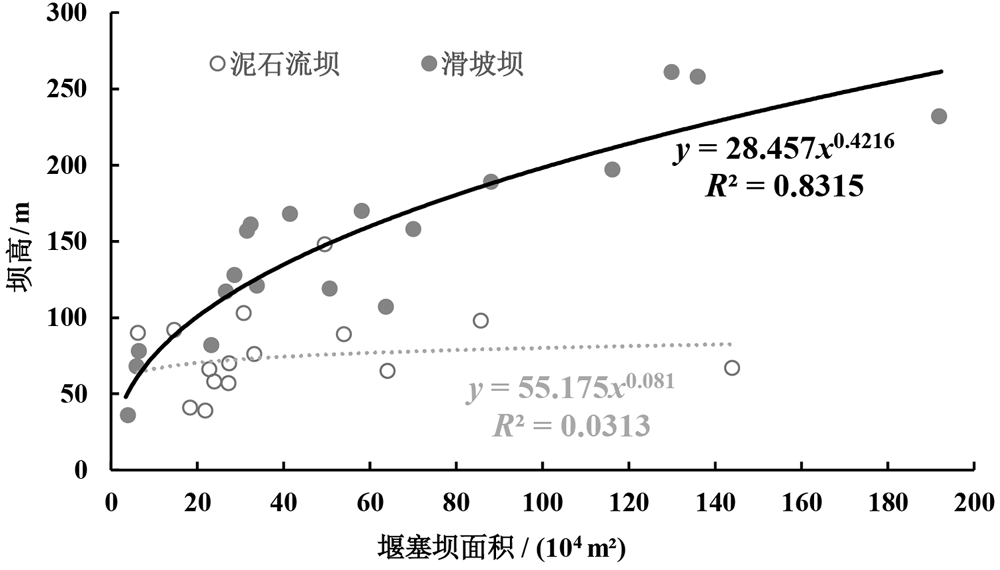
Fig.5 Characteristics of different types of dams

Fig.6 Distribution of knickpoints and dams at different elevation offset thresholds
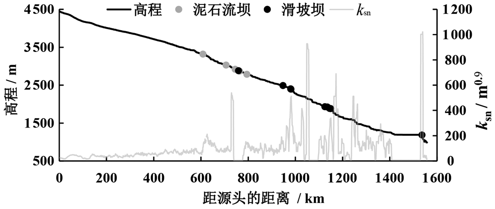
Fig.7 Longitudinal profile of the Yalong River mainstream
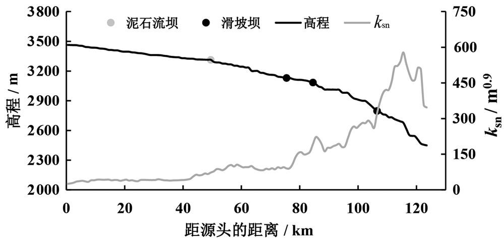
Fig.8 Longitudinal profile of the Liqiu River mainstream

Fig.9 Lithological map of the studied areas, showing the distribution of knickpoints and dams in each area
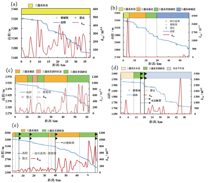
Fig.10 Correlation analysis of knickpoints with dams, fault lithology and steepness index for the five main stream sections(see Fig. 9b-d)
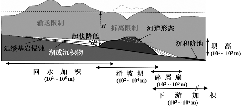
Fig.11 Schematic diagram showing the impact of dams on river longitudinal profile on a 1-104 year timescale. Modified after [11].
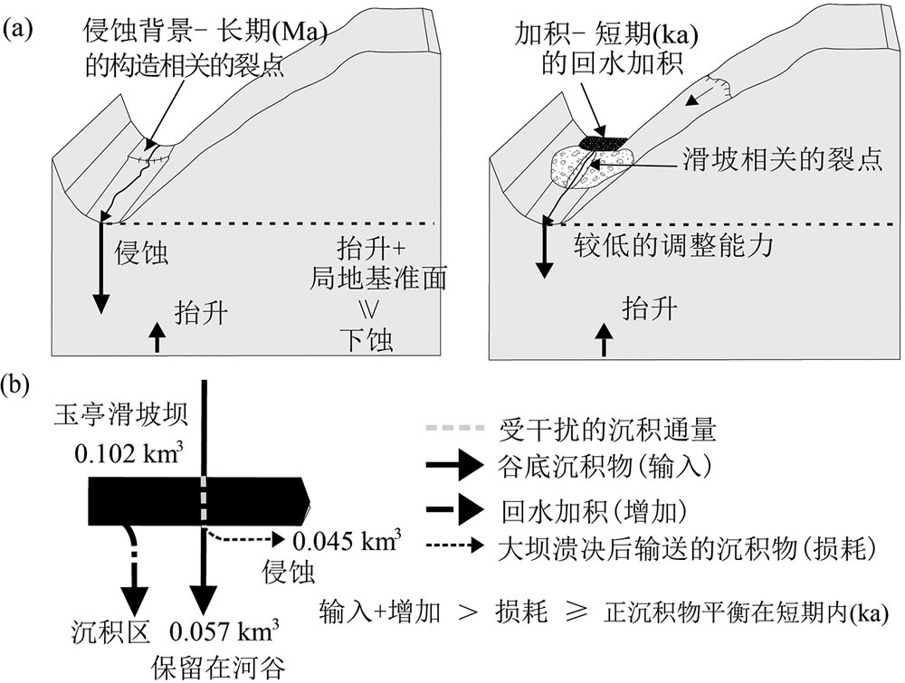
Fig.12 Schematic diagrams illustrating the formations of different types of river knickpoints. Modified after [55].
| [1] |
WHIPPLE K X. Bedrock rivers and the geomorphology of active orogens[J]. Annual Review of Earth and Planetary Sciences, 2004,32:151-185.
DOI URL |
| [2] |
BEAUMONT C, JAMIESON R A, NGUYEN M H, et al. Himalayan tectonics explained by extrusion of a low-viscosity crustal channel coupled to focused surface denudation[J]. Nature, 2001,414(6865):738-742.
DOI URL |
| [3] |
KIRBY E, WHIPPLE K X. Quantifying differential rock-uplift rates via stream profile analysis[J]. Geology, 2001,29(5):415-418.
DOI URL |
| [4] |
KIRBY E, WHIPPLE K X. Expression of active tectonics in erosional landscapes[J]. Journal of Structural Geology, 2012,44:54-75.
DOI URL |
| [5] |
WHIPPLE K X, HANCOCK G S, ANDERSON R S. River incision into bedrock: mechanics and relative efficacy of plucking, abrasion, and cavitation[J]. Geological Society of America Bulletin, 2000,112(3):490-503.
DOI URL |
| [6] |
WILLETT S D, MCCOY S W, PERRON J T, et al. Dynamic reorganization of river basins[J]. Science, 2014,343(6175):1248765.
DOI URL |
| [7] |
GOREN L, FOX M, WILLETT S D. Tectonics from fluvial topography using formal linear inversion: theory and applications to the Inyo Mountains, California[J]. Journal of Geophysical Research: Earth Surface, 2014,119(8):1651-1681.
DOI URL |
| [8] |
HU X F, PAN B T, KIRBY E, et al. Spatial differences in rock uplift rates inferred from channel steepness indices along the northern flank of the Qilian Mountain, northeast Tibetan Plateau[J]. Chinese Science Bulletin, 2010,55(27/28):3205-3214.
DOI URL |
| [9] |
WANG Y, ZHANG H, ZHENG D, et al. How a stationary knickpoint is sustained: new insights into the formation of the deep Yarlung Tsangpo Gorge[J]. Geomorphology, 2017,285:28-43.
DOI URL |
| [10] |
YANG R, WILLETT S D, GOREN L. In situ low-relief landscape formation as a result of river network disruption[J]. Nature, 2015,520(7548):526-529.
DOI URL |
| [11] |
KORUP O, DENSMORE A L, SCHLUNEGGER F. The role of landslides in mountain range evolution[J]. Geomorphology, 2010,120(1/2):77-90.
DOI URL |
| [12] |
KORUP O. Rock-slope failure and the river long profile[J]. Geology, 2006,34(1):45-48.
DOI URL |
| [13] |
KORUP O, STROM A L, WEIDINGER J T. Fluvial response to large rock-slope failures: examples from the Himalayas, the Tien Shan, and the Southern Alps in New Zealand[J]. Geomorphology, 2006,78(1/2):3-21.
DOI URL |
| [14] |
KORUP O, MONTGOMERY D R. Tibetan Plateau river incision inhibited by glacial stabilization of the Tsangpo gorge[J]. Nature, 2008,455(7214):786-789.
DOI URL |
| [15] | KORUP O, MONTGOMERY D R, HEWITT K. Glacier and landslide feedbacks to topographic relief in the Himalayan syntaxes[J]. Proceedings of the National Academy of Sciences of the United States of America, 2010,107(12):5317-5322. |
| [16] |
OUIMET W B, WHIPPLE K X, ROYDEN L H, et al. The influence of large landslides on river incision in a transient landscape: eastern margin of the Tibetan Plateau (Sichuan, China)[J]. Geological Society of America Bulletin, 2007,119(11/12):1462-1476.
DOI URL |
| [17] | WALSH L S, MARTIN A J, OJHA T P, et al. Correlations of fluvial knickzones with landslide dams, lithologic contacts, and faults in the southwestern Annapurna Range, central Nepalese Himalaya[J]. Journal of Geophysical Research: Earth Surface, 2012,117(F1):F01012. |
| [18] |
LIU W M, CARLING P A, HU K H, et al. Outburst floods in China: a review[J]. Earth-Science Reviews, 2019,197:102895.
DOI URL |
| [19] | CLARK M K, SCHOENBOHM L M, ROYDEN L H, et al. Surface uplift, tectonics, erosion of eastern Tibet from large-scale drainage patterns[J]. Tectonics, 2004,23(1): TC1006. |
| [20] | 刘静, 曾令森, 丁林, 等. 青藏高原东南缘构造地貌、活动构造和下地壳流动假说[J]. 地质科学, 2009,44(4):1227-1255. |
| [21] | 黄来斌, 白军红, 严登华, 等. 雅砻江流域湿地景观格局变化分析[J]. 长江流域资源与环境, 2012,21(增刊):140-147. |
| [22] | 常晓军, 魏伦武, 王德伟. 雅砻江流域地质灾害分布特征及其影响因素分析[J]. 灾害学, 2009,24(3):83-88. |
| [23] | 李峥嵘, 彭涛, 董晓华, 等. 雅砻江流域径流极值变化规律及影响因素分析[J]. 水力发电, 2020,46(5):33-37, 84. |
| [24] | 张建岭. 雅砻江中游构造地貌特征及演化[D]. 成都: 成都理工大学, 2012. |
| [25] | 张培震. 青藏高原东缘川西地区的现今构造变形、应变分配与深部动力过程[J]. 中国科学: D辑, 2008,38(9):1041-1056. |
| [26] | WHIPPLE K X, TUCKER G E. Implications of sediment-flux-dependent river incision models for landscape evolution[J]. Journal of Geophysical Research: Solid Earth, 2002, 107(B2): ETG 3-1 - ETG 3-20. |
| [27] | WHIPPLE K X, TUCKER G E. Dynamics of the stream-power river incision model: implications for height limits of mountain ranges, landscape response timescales, and research needs[J]. Journal of Geophysical Research: Solid Earth, 1999,104(B8):17661-17674. |
| [28] |
BURBANK D W. Rates of erosion and their implications for exhumation[J]. Mineralogical Magazine, 2002,66(1):25-52.
DOI URL |
| [29] |
WHIPPLE K X. Fluvial landscape response time: how plausible is steady-state denudation?[J]. American Journal of Science, 2001,301(4/5):313-325.
DOI URL |
| [30] |
MONTGOMERY D R, FOUFOULA-GEORGIOU E. Channel network source representation using digital elevation models[J]. Water Resources Research, 1993,29(12):3925-3934.
DOI URL |
| [31] | WHITTAKER A C, BOULTON S J. Tectonic and climatic controls on knickpoint retreat rates and landscape response times[J]. Journal of Geophysical Research: Earth Surface, 2012,117(F2):F02024. |
| [32] | STOCK J, DIETRICH W E. Valley incision by debris flows: evidence of a topographic signature[J]. Water Resources Research, 2003,39(4):1089. |
| [33] |
SCHLUNEGGER F, ZEILINGER G, KOUNOV A, et al. Scale of relief growth in the forearc of the Andes of Northern Chile (Arica latitude, 18°S)[J]. Terra Nova, 2006,18(3):217-223.
DOI URL |
| [34] |
SCHWANGHART W, SCHERLER D. TopoToolbox 2: MATLAB-based software for topographic analysis and modeling in Earth surface sciences[J]. Earth Surface Dynamics, 2014,2(1):1-7.
DOI URL |
| [35] | STOCK J D, MONTGOMERY D R. Geologic constraints on bedrock river incision using the stream power law[J]. Journal of Geophysical Research: Solid Earth, 1999,104(B3):4983-4993. |
| [36] | KIRBY E, JOHNSON C, FURLONG K, et al. Transient channel incision along Bolinas Ridge, California: evidence for differential rock uplift adjacent to the San Andreas fault[J]. Journal of Geophysical Research: Earth Surface, 2007, 112(F3): F03S07. |
| [37] |
PAN B T, LI Q, HU X F, et al. Bedrock channels response to differential rock uplift in eastern Qilian Mountain along the northeastern margin of the Tibetan Plateau[J]. Journal of Asian Earth Sciences, 2015,100:1-19.
DOI URL |
| [38] | 胡小飞, 潘保田, 李琼. 基岩河道水力侵蚀模型原理及其最新研究进展[J]. 兰州大学学报(自然科学版), 2014,50(6):824-831. |
| [39] | 王一舟, 张会平, 郑德文, 等. 基岩河道河流水力侵蚀模型及其应用: 兼论青藏高原基岩河道研究的迫切性[J]. 第四纪研究, 2016,36(4):884-897. |
| [40] |
ZHANG HP, KIRBY E, PITLICK J, et al. Characterizing the transient geomorphic response to base-level fall in the northeastern Tibetan Plateau[J]. Journal of Geophysical Research: Earth Surface, 2017,122(2):546-572.
DOI URL |
| [41] | KIRBY E, WHIPPLE K X, TANG WQ, et al. Distribution of active rock uplift along the eastern margin of the Tibetan Plateau: inferences from bedrock channel longitudinal profiles[J]. Journal of Geophysical Research: Solid Earth, 2003,108(B4):2217. |
| [42] |
SCHWANGHART W, SCHERLER D. Bumps in river profiles: uncertainty assessment and smoothing using quantile regression techniques[J]. Earth Surface Dynamics, 2017,5(4):821-839.
DOI URL |
| [43] | XU C, SHYU J B H, SHYU J B H . Landslides triggered by the 12 January 2010 Port-au-Prince, Haiti, Mw=7.0 earthquake: visual interpretation, inventory compiling, and spatial distribution statistical analysis[J]. Natural Hazards and Earth System Sciences, 2014,2:1789-1881. |
| [44] | 李松, 邓宝昆, 徐红勤, 等. 地震型滑坡灾害遥感快速识别方法研究[J]. 遥感信息, 2015,30(4):25-28. |
| [45] | 王孔伟, 邓成进, 张帆. 中国西南雅砻江流域唐古栋滑坡及雨日堆积体形成机理分析[J]. 工程地质学报, 2012,20(6):955-970. |
| [46] | 武运泊. 雅砻江卡拉地区滑坡发育规律与成因机制分析[D]. 成都: 成都理工大学, 2015. |
| [47] | 王治华. 滑坡遥感[M]. 北京: 科学出版社, 2012. |
| [48] | 严祖文, 魏迎奇, 蔡红. 堰塞坝形成机理及稳定性分析[J]. 中国地质灾害与防治学报, 2009,20(4):55-59. |
| [49] |
LARSEN I J, MONTGOMERY D R, KORUP O. Landslide erosion controlled by hillslope material[J]. Nature Geoscience, 2010,3(4):247-251.
DOI URL |
| [50] | 周丽琴, 刘维明, 赖忠平, 等. 河流堰塞的地貌响应[J]. 第四纪研究, 2019,39(2):366-380. |
| [51] | FAN X M, YUNUS A P, JANSEN J D, et al. Comment on ‘Gigantic rockslides induced by fluvial incision in the Diexi area along the eastern margin of the Tibetan Plateau’ by Zhao et al. (2019) Geomorphology 338, 27-42[J]. Geomorphology, 2019, 106963. https://doi.org/10.1016/j.geomorph.2019.106963. |
| [52] |
LIU WM, LAI Z P, HU K H, et al. Age and extent of a giant glacial-dammed lake at Yarlung Tsangpo gorge in the Tibetan Plateau[J]. Geomorphology, 2015,246:370-376.
DOI URL |
| [53] |
CLARK M K, HOUSE M A, ROYDEN L H, et al. Late Cenozoic uplift of southeastern Tibet[J]. Geology, 2005,33(6):525-528.
DOI URL |
| [54] |
OUIMET W B, WHIPPLE K X, GRANGER D E. Beyond threshold hillslopes: channel adjustment to base-level fall in tectonically active mountain ranges[J]. Geology, 2009,37(7):579-582.
DOI URL |
| [55] |
PENNA I M, HERMANNS R L, DAICZ S, et al. Effects of tectonic deformation and landslides in the erosion of a mountain plateau in the transitional zone between the central and Patagonian Andes[J]. American Journal of Science, 2015,315:257-274.
DOI URL |
| [1] | CHEN Yun-Tai. From SumatraAndaman to Tohoku, Japan: Lessons from the great earthquakes and the earthquakegenerated megatsunamis. [J]. Earth Science Frontiers, 20140101, 21(1): 120-131. |
| [2] | ZHANG Aikui, YUAN Wanming, LIU Guanglian, ZHANG Yong, WANG Zhouxin, SUN Feifei, LIU Zhigang. Metallogenic regularities and exploration directions of strategic metallic minerals around the Qaidam Basin [J]. Earth Science Frontiers, 2024, 31(3): 260-283. |
| [3] | LI Bingshuai, YAN Maodu, ZHANG Weilin. Early Cenozoic rotation feature in the northern Qaidam marginal thrust belt and its tectonic implications [J]. Earth Science Frontiers, 2022, 29(4): 249-264. |
| [4] | WANG Jiaqi, LI Zongxing, LIU Kui. Rehabilitation status of denuded land in the eastern Qaidam Basin: Geophysical and thermochronological evidences [J]. Earth Science Frontiers, 2022, 29(4): 371-384. |
| [5] | HUANG Ranxiao, WANG Guosheng, YUAN Guoli, QIU Kunfeng, Hounkpe Jechonias BIDOSSESSI. Assimilation-fractional crystallization (AFC) of pegmatitic magma and its implications for uranium mineralization: A case study of the Husab uranium deposit, Namibia [J]. Earth Science Frontiers, 2022, 29(1): 377-402. |
| [6] | FAN Fu, HOU Xianhua, ZHENG Mianping, MENG Fanwei, YANG Zhenjing, MIAO Qing. Homogenization temperature of fluid inclusions in Early-Middle Pleistocene halite from Liang Hole ZK02 in Dalangtan area, Qaidam Basin and its constraints on potash mineralization [J]. Earth Science Frontiers, 2021, 28(6): 105-114. |
| [7] | HOU Xianhua, WANG Wei, ZHENG Mianping, FAN Fu, LI Hongpu, GAO Xuefeng. Seismic response characteristics of the Heibei Concave-Dalangtan potassium-rich deep brine reservoir in western Qaidam Basin [J]. Earth Science Frontiers, 2021, 28(6): 134-145. |
| [8] | ZHAO Junmeng, ZHANG Peizhen, ZHANG Xiankang, Xiaohui YUAN, Rainer KIND, Robert van der HILST, GAN Weijun, SUN Jimin, DENG Tao, LIU Hongbing, PEI Shunping, XU Qiang, ZHANG Heng, JIA Shixu, YAN Maodu, GUO Xiaoyu, LU Zhanwu, YANG Xiaoping, DENG Gong, JU Changhui. Crust-mantle structure and geodynamic processes in western China and their constraints on resources and environment: Research progress of the ANTILOPE Project [J]. Earth Science Frontiers, 2021, 28(5): 230-259. |
| [9] | YANG Jinzhong, XU Wenjia, YAO Weiling, SUN Yaqin. Land destroyed by mining in China: Damage distribution, rehabilitation status and existing problems [J]. Earth Science Frontiers, 2021, 28(4): 83-89. |
| [10] | ZHANG Jingtao, SHI Zheming, WANG Guangcai, JIANG Jun, YANG Bingchao. Hydrochemical characteristics and evolution of groundwater in the Dachaidan area, Qaidam Basin [J]. Earth Science Frontiers, 2021, 28(4): 194-205. |
| [11] | CHENG Qiuming. What are Mathematical Geosciences and its frontiers? [J]. Earth Science Frontiers, 2021, 28(3): 6-25. |
| [12] | YIN Zhiqiang, WEI Gang, QIN Xiaoguang, LI Wenjuan, ZHAO Wuji. Research progress on landslides and dammed lakes in the upper reaches of the Yellow River, northeastern Tibetan Plateau [J]. Earth Science Frontiers, 2021, 28(2): 46-57. |
| [13] | FAN Xuanmei, DAI Lanxin, ZHONG Yujin, LI Jingjuan, WANG Lansheng. Recent research on the Diexi paleo-landslide: dam and lacustrine deposits upstream of the Minjiang River, Sichuan, China [J]. Earth Science Frontiers, 2021, 28(2): 71-84. |
| [14] | CHEN Jian, CUI Zhijiu, CHEN Ruichen, ZHENG Xinxin. The origin and evolution of the Temi paleolandslide-dammed lake in the upper Jinsha River [J]. Earth Science Frontiers, 2021, 28(2): 85-93. |
| [15] | SU Huai, SHI Zhengtao, DONG Ming, YE Liaoyuan, YE Lei. The geomorphic process and sedimentary characteristics of the “11·3” Baige Dammed Lake outburst flood event in the upper reaches of the Jinsha River from Benzilan to Shihku [J]. Earth Science Frontiers, 2021, 28(2): 202-210. |
| Viewed | ||||||
|
Full text |
|
|||||
|
Abstract |
|
|||||