地学前缘 ›› 2026, Vol. 33 ›› Issue (1): 405-418.DOI: 10.13745/j.esf.sf.2025.10.30
乔小娟1,2( ), 罗承可1, 柴新宇1, 于文瑾1
收稿日期:2025-08-24
修回日期:2025-09-26
出版日期:2026-11-25
发布日期:2025-11-10
作者简介:乔小娟(1982—),女,博士,副教授,研究生导师,主要从事水文地球化学与数值模拟方面的研究。E-mail: qiaoxj@ucas.ac.cn
基金资助:
QIAO Xiaojuan1,2(), LUO Chengke1, CHAI Xinyu1, YU Wenjin1
Received:2025-08-24
Revised:2025-09-26
Online:2026-11-25
Published:2025-11-10
摘要:
岩溶裂隙发育具有高维、非线性及空间异质性特征,如何刻画裂隙的空间展布是岩溶发育规律研究的难点。以多源数据驱动的机器学习建模方法可以有效捕捉裂隙系统中隐含的非线性、非连续的特征,从而显著地提高裂隙识别与刻画的效率与精度。本研究以北京市房山张坊地区为研究对象,基于翔实的野外裂隙实测数据,系统融合了地表地形信息、区域构造背景、地层岩性分布以及地下水位等多源数据集。利用机器学习框架构建了一套综合性的定量化特征体系,该体系涵盖了断层空间影响、地层岩性组合特征、地下水埋深变化以及高精度地形衍生属性(如坡度、曲率等)等多个维度的指标。重点研究对比了支持向量回归、极致梯度提升树及随机森林这三种机器学习方法,旨在预测研究区内岩溶裂隙的发育与空间分布情况。结果表明,基于随机森林构建的预测模型表现最为优异。该模型的裂隙密度、节理走向与倾角的模拟结果与实测统计数据最符合,模型表现最为稳健,具有良好的泛化能力和方法适用性,在表达多期次裂隙发育等复杂地质过程方面具有独特优势。本研究的结果揭示,将数据驱动模型与深入的地质机理分析相融合,是突破复杂岩溶系统定量化表征与预测难题的一条有效途径。
中图分类号:
乔小娟, 罗承可, 柴新宇, 于文瑾. 基于机器学习的岩溶裂隙空间分布预测研究:以北京房山为例[J]. 地学前缘, 2026, 33(1): 405-418.
QIAO Xiaojuan, LUO Chengke, CHAI Xinyu, YU Wenjin. Prediction of fracture distribution in karst area based on machine learning method: Taking Fangshan area in Beijing as a case study[J]. Earth Science Frontiers, 2026, 33(1): 405-418.
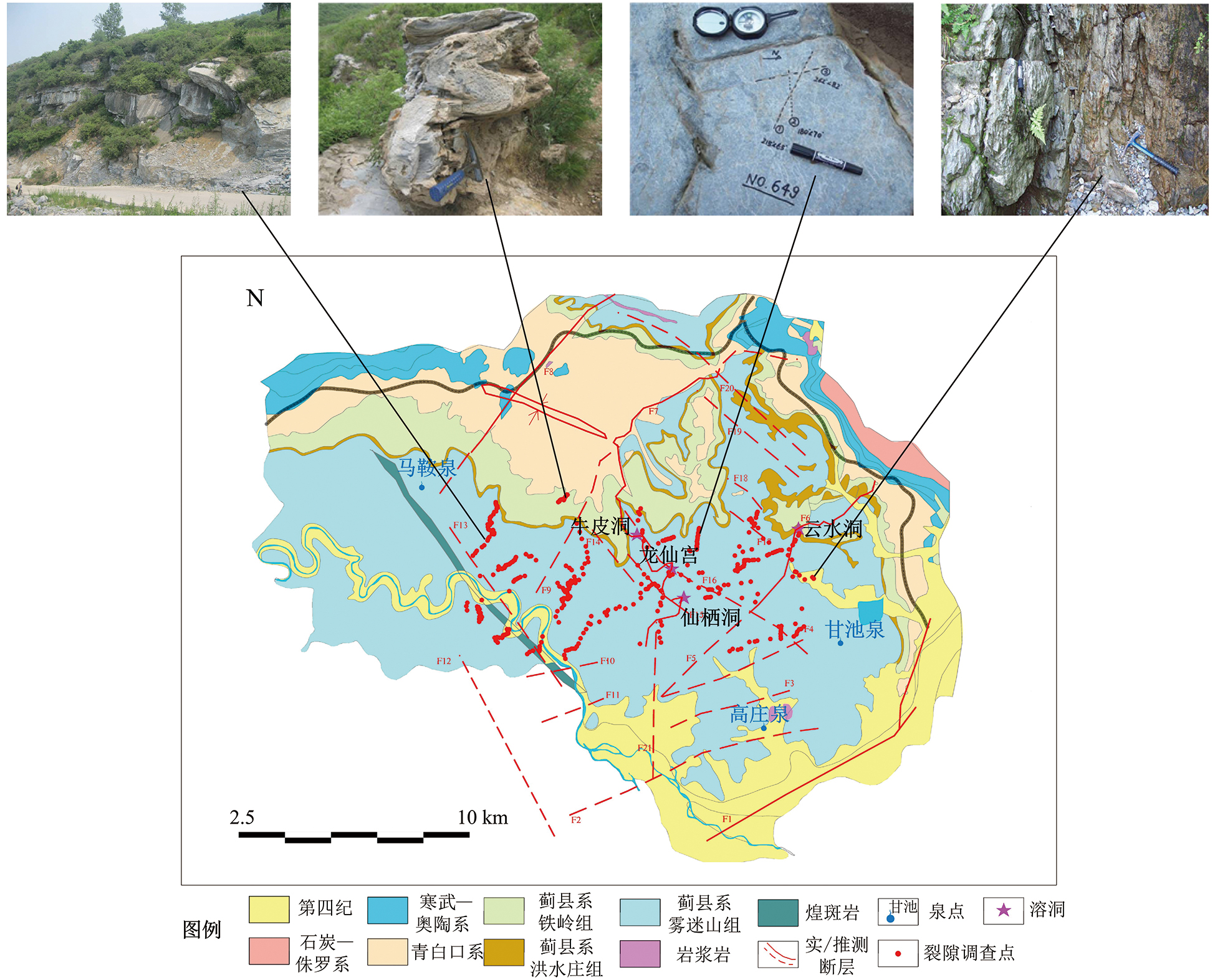
图1 研究区水文地质概图及岩溶裂隙调查点位分布
Fig.1 Hydrogeology map and karst fracture survey points in the study area
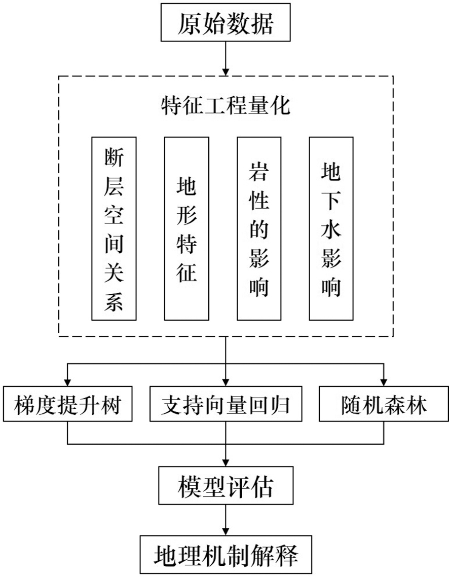
图2 研究流程图
Fig.2 Research Workflow Diagram

图3 支持向量机分类示意图
Fig.3 Schematic diagram of support vector machine classification
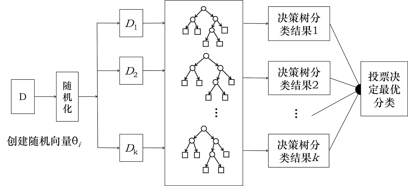
图4 随机森林原理示意图(据文献[64])
Fig.4 Schematic diagram of random forest principle. Adapted from [64].
| 参数名称 | 测试值 | 最优值 |
|---|---|---|
| 决策树数量(n_estimators) | 100~500 | 400 |
| 决策树的最大深度(max_depth) | 5, 10, 15, 20 | 15 |
| 最大分离特征数(max_features) | 1~5, ‘sqrt’, ‘log’ | ‘sqrt’ |
| 最小分离样本数(min_samples_split) | 2~20 | 5 |
| 最小叶子节点样本数(min_samples_leaf) | 1~10 | 3 |
表1 随机森林模型超参数优化结果
Table 1 Hyperparameter optimization results of Random Forest Model
| 参数名称 | 测试值 | 最优值 |
|---|---|---|
| 决策树数量(n_estimators) | 100~500 | 400 |
| 决策树的最大深度(max_depth) | 5, 10, 15, 20 | 15 |
| 最大分离特征数(max_features) | 1~5, ‘sqrt’, ‘log’ | ‘sqrt’ |
| 最小分离样本数(min_samples_split) | 2~20 | 5 |
| 最小叶子节点样本数(min_samples_leaf) | 1~10 | 3 |
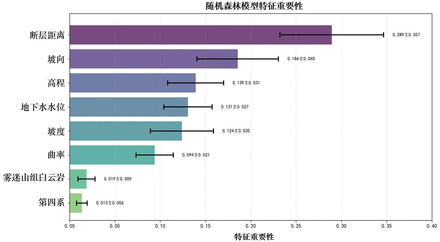
图5 随机森林特征重要性条形图
Fig.5 Bar chart of random forest feature importance
| 参数名称 | 测试值 | 最优值 |
|---|---|---|
| 决策树的数量 (n_estimators) | 100, 200, 300, 400, 500 | 200 |
| 单棵树的最大深度 (max_depth) | 3, 4, 5, 6, 7, 8, 9 | 5 |
| 学习率(learning_rate) | 0.01, 0.05, 0.1, 0.15, 0.2 | 0.05 |
| 节点所需的最小样本权重和 (min_child_weight) | 1, 3, 5, 7 | 3 |
| 分裂阈值(gamma) | 0, 0.1, 0.2, 0.3, 0.4 | 0 |
| 样本采样率(subsample) | 0.6, 0.7, 0.8, 0.9, 1.0 | 1.0 |
| 特征采样率 (colsample_bytree) | 0.6, 0.7, 0.8, 0.9, 1.0 | 0.7 |
表2 极致梯度提升树模型超参数优化结果
Table 2 Hyperparameter optimization results of Extreme Gradient Boosting Trees Model
| 参数名称 | 测试值 | 最优值 |
|---|---|---|
| 决策树的数量 (n_estimators) | 100, 200, 300, 400, 500 | 200 |
| 单棵树的最大深度 (max_depth) | 3, 4, 5, 6, 7, 8, 9 | 5 |
| 学习率(learning_rate) | 0.01, 0.05, 0.1, 0.15, 0.2 | 0.05 |
| 节点所需的最小样本权重和 (min_child_weight) | 1, 3, 5, 7 | 3 |
| 分裂阈值(gamma) | 0, 0.1, 0.2, 0.3, 0.4 | 0 |
| 样本采样率(subsample) | 0.6, 0.7, 0.8, 0.9, 1.0 | 1.0 |
| 特征采样率 (colsample_bytree) | 0.6, 0.7, 0.8, 0.9, 1.0 | 0.7 |
| 参数名称 | 测试值范围 | 最优值 |
|---|---|---|
| 正则化参数(C) | 0.1, 1, 10, 100 | 10 |
| 不敏感区域宽度(epsilon) | 0.01, 0.1, 0.5 | 0.5 |
| 核函数参数(gamma) | ‘scale’, ‘auto’, 0.1, 1 | ’scale’ |
表3 支持向量回归模型超参数优化结果
Table 3 Hyperparameter optimization results of Support Vector Regression Model
| 参数名称 | 测试值范围 | 最优值 |
|---|---|---|
| 正则化参数(C) | 0.1, 1, 10, 100 | 10 |
| 不敏感区域宽度(epsilon) | 0.01, 0.1, 0.5 | 0.5 |
| 核函数参数(gamma) | ‘scale’, ‘auto’, 0.1, 1 | ’scale’ |
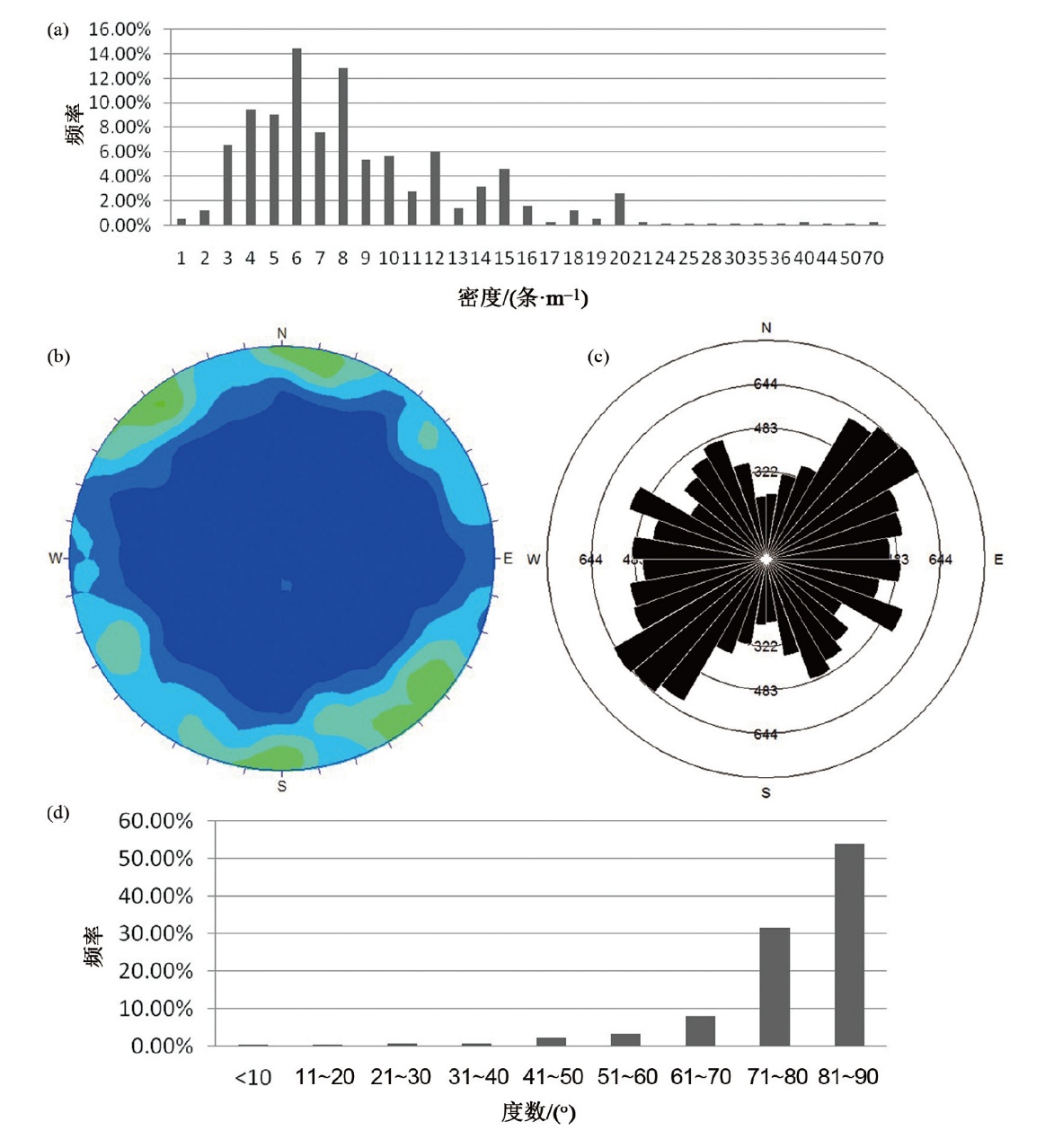
图6 研究区裂隙展布统计分析图 (a)节理密度分布特征图;(b)全区节理等密图;(c)全区节理走向玫瑰花图;(d)节理倾角分布特征图。
Fig.6 Statistical analysis figures of fracture distribution in the study area

图7 裂隙密度预测热力图 (a)随机森林;(b)极致梯度提升树;(c)支持向量回归。
Fig.7 Predictive heatmap of fracture density

图8 预测裂隙走向玫瑰图 (a)随机森林;(b)极致梯度提升树;(c)支持向量回归。
Fig.8 Rose figures of predicting fracture orientation
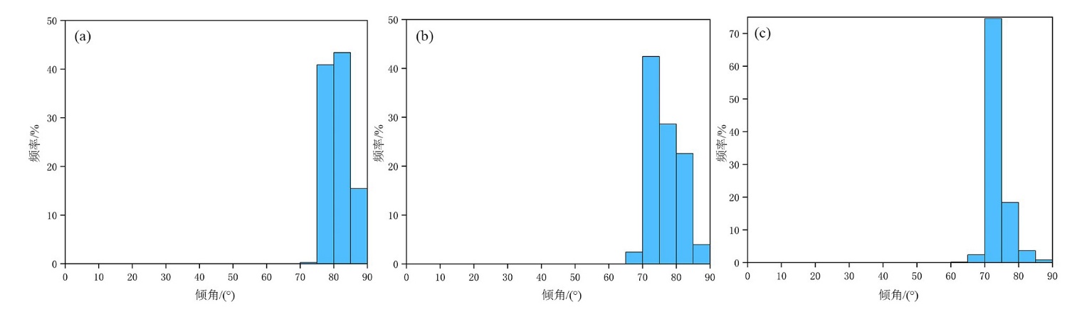
图9 预测裂隙倾角直方图 (a)随机森林;(b)极致梯度提升树;(c)支持向量回归。
Fig.9 Prediction of fracture dip angle histogram
| 模型类型 | R2 | MSE | 训练时间/s |
|---|---|---|---|
| 支持向量回归 | 0.605 | 3.417 | 23 |
| 随机森林 | 0.785 | 2.482 | 85 |
| 极致梯度提升树 | 0.536 | 5.684 | 24 |
表4 模型结果对比
Table 4 Comparison of model results
| 模型类型 | R2 | MSE | 训练时间/s |
|---|---|---|---|
| 支持向量回归 | 0.605 | 3.417 | 23 |
| 随机森林 | 0.785 | 2.482 | 85 |
| 极致梯度提升树 | 0.536 | 5.684 | 24 |
| [1] | 袁道先. 中国岩溶学[M]. 北京: 地质出版社, 1994: 5. |
| [2] | 胡鹏, 朱国荣, 江思珉. 裂隙网络模型在地下水数值模拟中的应用研究进展[J]. 工程勘察, 2013, 41(11): 44-49. |
| [3] | 黄宇, 杨荣森, 韩晓东, 等. 基于定向半变异函数的裂隙网络空间变异性分析[J]. 地质科技通报, 2023, 42(2): 186-193. |
| [4] |
HOU W, CHEN Y, LIU H, et al. Reconstructing three-dimensional geological structures by the multiple-point statistics method coupled with a deep neural network: a case study of a metro station in Guangzhou, China[J]. Tunnelling and Underground Space Technology, 2023, 136: 105089.
DOI URL |
| [5] |
MA L, LIU Y, ZHANG X, et al. Deep learning in remote sensing applications: a meta-analysis and review[J]. ISPRS Journal of Photogrammetry and Remote Sensing, 2019, 152: 166-177.
DOI |
| [6] | 周培诚, 程塨, 姚西文, 等. 高分辨率遥感影像解译中的机器学习范式[J]. 遥感学报, 2021, 25(1): 182-197. |
| [7] |
王斌, 范冬林. 深度学习在遥感影像分类与识别中的研究进展综述[J]. 测绘通报, 2019(2): 99-102, 136.
DOI |
| [8] | LIU X, YU J, SONG W, et al. Remote sensing image classification algorithm based on texture feature and extreme learning machine[J]. Computers, Materials & Continua, 2020, 65(2): 1385-1395. |
| [9] |
SHEYKHMOUSA M., MAHDIANPARI M., GHANBARI H., et al. Support vector machine versus random forest for remote sensing image classification: a meta-analysis and systematic review[J]. IEEE Journal of Selected Topics in Applied Earth Observations and Remote Sensing, 2020, 13: 6308-6325.
DOI URL |
| [10] |
SUN K, CHEN Y S, GENG G S, et al. A review of mineral prospectivity mapping using deep learning[J]. Minerals, 2024, 14: 1021.
DOI URL |
| [11] | 李苍柏, 肖克炎, 李楠, 等. 支持向量机、随机森林和人工神经网络机器学习算法在地球化学异常信息提取中的对比研究[J]. 地球学报, 2020, 41(2): 309-319. |
| [12] | 刘艳鹏, 朱立新, 周永章. 卷积神经网络及其在矿床找矿预测中的应用: 以安徽省兆吉口铅锌矿床为例[J]. 岩石学报, 2018, 34(11): 3217-3224. |
| [13] |
ZHAO J, HE L, GONG J, et al. Predicting manganese mineralization using multi-source remote sensing and machine learning: a case study from the malkansu manganese belt, Western Kunlun[J]. Minerals, 2025, 15(2): 113.
DOI URL |
| [14] | CARVALHO M, AZZALINI A, CARDOSO-FERNANDES J, et al. Multi-sensor approach for cobalt exploration in Asturias (Spain) using machine learning Algorithms[C]// IGARSS 2024—2024 IEEE International Geoscience and Remote Sensing Symposium, Athens, Greece. 2024: 2122-2126. |
| [15] | 孙玉洁, 李晓彦, 张超. 基于机器学习的黑云母成分判别花岗岩成因类型方法研究[J]. 现代地质, 2025, 39(3): 523-540. |
| [16] |
简富源, 张子鸣, 董岳霖, 等. 基于多重分形与随机森林的新疆哈巴河金矿成矿预测[J]. 地学前缘, 2025, 32(4): 78-94.
DOI |
| [17] | 刘艳辉, 方然可, 苏永超, 等. 基于机器学习的区域滑坡灾害预警模型研究[J]. 工程地质学报, 2021, 29(1): 116-124. |
| [18] | 窦杰, 向子林, 许强, 等. 机器学习在滑坡智能防灾减灾中的应用与发展趋势[J]. 地球科学, 2023, 48(5): 1657-1674. |
| [19] |
周萍, 邓辉, 张文江, 等. 基于信息量模型和机器学习方法的滑坡易发性评价研究: 以四川理县为例[J]. 地理科学, 2022, 42(9): 1665-1675.
DOI |
| [20] |
BRUZÓN A G, ARROGANTE-FUNES P, ARROGANTE-FUNES F, et al. Landslide susceptibility assessment using an AutoML Framework[J]. International Journal of Environmental Research and Public Health, 2021, 18(20): 10971.
DOI URL |
| [21] |
BIAN Y, CHEN H, LIU Z, et al. Geological disaster susceptibility evaluation using machine learning: a case study of the Atal Tunnel in Tibetan Plateau[J]. Sustainability, 2024, 16(11): 4604.
DOI URL |
| [22] | 麻晟, 陈剑, 李强, 等. 负样本选择和评价模型对滑坡易发性预测不确定性的影响[J/OL]. 现代地质, 2025: 1-20[2025-10-22]. https://doi.org/10.19657/j.geoscience.1000-8527.2025.013. |
| [23] | 应欣翰, 吴彩燕, 贾应, 等. 机器学习驱动的滑坡易发性多模型分级优化研究: 以四川省理县为例[J/OL]. 现代地质, 2025: 1-21[2025-10-22]. https://link.cnki.net/urlid/11.2035.P.20251010.1453.002. |
| [24] | El-Omairi MA, El Garouani A. A review on advancements in lithological mapping utilizing machine learning algorithms and remote sensing data[J]. Heliyon, 2023, 9(9): e20168. doi: 10.1016/j.heliyon.2023.e20168. |
| [25] | 王啟, 杨添微, 刘永震, 等. 基于随机森林算法的复杂碳酸盐岩岩性识别[J]. 工程地球物理学报, 2020, 17(5): 550-558. |
| [26] |
肖凡, 杨华清, 唐奥, 等. 基于机器学习与多源数据融合的东天山戈壁沙漠覆盖区中-酸性侵入岩岩性填图[J]. 地学前缘, 2025, 32(4): 199-212.
DOI |
| [27] |
叶舒婉, 侯卫生, 杨玠, 等. 三维地质智能建模研究进展[J]. 地学前缘, 2025, 32(4): 182-198.
DOI |
| [28] |
GHONEIM M S, HAMIMI Z, ABDELRAHMAN K, et al. Machine learning and remote sensing-based lithological mapping of the Duwi Shear-Belt area, Central Eastern Desert, Egypt[J]. Scientific Reports, 2024, 14(1): 17010-17010.
DOI PMID |
| [29] |
RAN X, XUE L, ZHANG Y, et al. Rock classification from field image patches analyzed using a deep convolutional neural network[J]. Mathematics, 2019, 7(8): 755.
DOI URL |
| [30] | 孙虹洁, 赵振华, 黄林显, 等. 多变量LSTM神经网络模型在地下水位预测中的应用[J]. 人民黄河, 2022, 44(8): 69-75. |
| [31] |
胡义明, 陈腾, 罗序义, 等. 基于机器学习模型的淮河流域中长期径流预报研究[J]. 地学前缘, 2022, 29(3): 284-291.
DOI |
| [32] | 齐永强, 李文鹏, 郑跃军, 等. 地下水机器学习方法研究: 水位监测数据驱动的区域补排边界识别[J]. 水文地质工程地质, 2022, 49(1): 1-11. |
| [33] |
IGWEBUIKE N, AJAYI M, OKOLIE C, et al. Application of machine learning and deep learning for predicting groundwater levels in the West Coast Aquifer System, South Africa[J]. Earth Science Informatics, 2024, 18(1): 6.
DOI |
| [34] | 曹文庚, 付宇, 南天, 等. 机器学习在地下水环境背景值与污染风险评价的应用和展望[J]. 地质学报, 2023, 97(7): 2408-2424. |
| [35] | 肖燚, 郭亚会, 李明蔚, 等. 基于机器学习的地下水水质预测研究[J]. 北京师范大学学报(自然科学版), 2022, 58(2): 261-268. |
| [36] |
WU X, LIU W, LIU Y, et al. Hydrogeochemical characteristics and formation mechanisms of high-arsenic groundwater in the North China Plain: insights from hydrogeochemical analysis and unsupervised machine learning[J]. Water, 2024, 16(22): 3215-3215.
DOI URL |
| [37] |
LIANG Y Y, ZHANG X J, SUN Y G, et al. Enhanced groundwater vulnerability assessment to nitrate contamination in Chongqing, Southwest China: integrating novel explainable machine learning algorithms with DRASTIC-LU[J]. Hydrology Research, 2024, 55(6): 663-682.
DOI URL |
| [38] | 关铁生, 鲍振鑫, 贺瑞敏, 等. 无资料地区水文模型参数移植不确定性分析[J]. 水科学进展, 2023, 34(5): 660-672. |
| [39] | 强玲娟, 常安定, 陈玉雪. 机器学习算法反求水文地质参数[J]. 煤田地质与勘探, 2017, 45(3): 87-90, 95. |
| [40] | 丁千, 张舒, 黄锐, 等. 数据驱动动力学与控制研究若干进展[J/OL]. 力学进展, 2025: 1-76. (2025-04-11)[2025-06-19]. https://link.cnki.net/urlid/11.1774.O3.20250411.1049.002. |
| [41] | 易文豪, 王明年, 童建军, 等. 基于支持向量机的大断面岩质隧道掌子面围岩非均一性判识方法[J]. 中国铁道科学, 2021, 42(5): 112-122. |
| [42] | 卢宇杭, 孟治霖, 丁一, 等. 基于深度学习的裂隙智能提取研究[J]. 科技创新与应用, 2025, 15(13): 9-13. |
| [43] |
XIN W, TIAN F, SHAN X, et al. Application of geologically constrained machine learning method in characterizing paleokarst reservoirs of Tarim Basin, China[J]. Water, 2020, 12(6): 1765.
DOI URL |
| [44] |
LHARTI H, SIRIEIX C, MARACHE A, et al. 3D modelling of rock mass heterogeneities in unsaturated karst using geophysics, clustering and geostatistics[J]. Engineering Geology, 2025, 350: 107994-107994.
DOI URL |
| [45] |
刘建明, 张玉修, 曾璐, 等. 北京张坊地区中上元古界中岩溶发育与构造作用[J]. 中国科学院大学学报, 2019, 36(2): 208-217.
DOI |
| [46] |
董莹, 琚宜文, 张玉修, 等. 北京房山张坊岩溶区节理发育特征及其对岩溶作用的影响[J]. 中国科学院大学学报, 2014, 31(6): 783-790.
DOI |
| [47] | 辛宝东. 北京市房山区岩溶地下水水文地球化学特征[J]. 水文地质工程地质, 2005(3): 74-75. |
| [48] | 沈媛媛, 辛宝东, 郭高轩, 等. 北京房山应急水源地地下水数值模拟及河流渗漏量预测[J]. 城市地质, 2011, 6(4): 36-40. |
| [49] | 乔小娟, 侯泉林, 琚宜文, 等. 北京张坊地区岩溶地下水运移富集的构造控制分析[J]. 中国岩溶, 2014, 33(2): 184-191. |
| [50] | 李世君. 北京张坊岩溶地下水库特征及调蓄能力研究[D]. 北京: 中国地质大学(北京), 2012. |
| [51] | 南英华, 郭高轩, 代垠东, 等. 北京张坊应急备用水源地水位动态多时间尺度演变特征及安全供水调控[J]. 地质通报, 2025, 44(8): 1472-1485. |
| [52] | 郭高轩, 代垠东, 许亮, 等. 北京西山岩溶地下水化学特征及成因分析[J]. 环境科学, 2024, 45(2): 802-812. |
| [53] | 王晓红, 刘久荣, 辛宝东, 等. 北京岩溶水系统划分及特征分析[J]. 城市地质, 2016, 11(3): 8-15. |
| [54] |
赵春红, 李强, 梁永平, 等. 北京西山黑龙关泉域岩溶水系统边界与水文地质性质[J]. 地球科学进展, 2014, 29(3): 412-419.
DOI |
| [55] | 杨楠, 李世君, 孙颖, 等. 北京房山岩溶区节理裂隙分布特征研究[J]. 城市地质, 2014, 9(1): 30-32. |
| [56] | 丁世飞, 齐丙娟, 谭红艳. 支持向量机理论与算法研究综述[J]. 电子科技大学学报, 2011, 40(1): 2-10. |
| [57] |
CERVANTES J, GARCIA-LAMONT F, RODRÍGUEZ-MAZAHUA L, et al. A comprehensive survey on support vector machine classification: applications, challenges and trends[J]. Neurocomputing, 2020, 408: 189-215.
DOI URL |
| [58] |
FRIEDMAN H J. Greedy function approximation: a gradient boosting machine[J]. The Annals of Statistics, 2001, 29(5): 1189-1232.
DOI URL |
| [59] |
FREUND Y, SCHAPIRE R E. A decision-theoretic generalization of on-line learning and an application to boosting[J]. Journal of computer and system sciences, 1997, 55(1): 119-139.
DOI URL |
| [60] | ENATEKIN A, EKNOLL A. Gradient boosting machines, a tutorial[J]. Frontiers in Neurorobotics, 2013, 721: 1-20. |
| [61] | 周杰英, 贺鹏飞, 邱荣发, 等. 融合随机森林和梯度提升树的入侵检测研究[J]. 软件学报, 2021, 32(10): 3254-3265. |
| [62] |
MOSHE S H J M. Conservation machine learning: a case study of random forests[J]. Scientific Reports, 2021, 11(1): 3629-3629.
DOI PMID |
| [63] | 王奕森, 夏树涛. 集成学习之随机森林算法综述[J]. 信息通信技术, 2018, 12(1): 49-55. |
| [64] | 方匡南, 吴见彬, 朱建平, 等. 随机森林方法研究综述[J]. 统计与信息论坛, 2011, 26(3): 32-38. |
| [65] | 常绍舜. 从经典系统论到现代系统论[J]. 系统科学学报, 2011, 19(3): 1-4. |
| [66] |
孙利民, 尚志强, 夏烨. 大数据背景下的桥梁结构健康监测研究现状与展望[J]. 中国公路学报, 2019, 32(11): 1-20.
DOI |
| [67] | LIU H, HIROSHI MOTODA. Feature extraction, construction and selection: a data mining perspective[M]. Berlin: Springer Science & Business Media, 1998. |
| [68] | 杨立洪, 白肇强. 基于二次组合的特征工程与XGBoost模型的用户行为预测[J]. 科学技术与工程, 2018, 18(14): 186-189. |
| [69] |
MENZE B H, KELM B M, MASUCH R, et al. A comparison of random forest and its Gini importance with standard chemometric methods for the feature selection and classification of spectral data[J]. BMC Bioinformatics, 2009, 10: 213.
DOI PMID |
| [70] | 李成龙. 影像大地测量揭示的走滑型地震损伤带分布式变形与剪切力学性质[D]. 北京: 中国地震局地质研究所, 2024. |
| [1] | 康金正, 莫绍星, 康学远, 党婧萱, 程迟吉太, 徐培杰, 施小清. 机器学习在地下水科学中的前沿进展与挑战[J]. 地学前缘, 2026, 33(1): 483-499. |
| [2] | 周斐然, 尹子悦, 孙晓敏, 宋健, 杨蕴, 吴剑锋. 融合数值模拟和机器学习的民勤盆地地下水潜力评价与主控因素识别[J]. 地学前缘, 2026, 33(1): 511-522. |
| [3] | 娄渝明, 康旭, 赖渊平, 龚建生, 周涤非, 窦世荣, 樊炳良, 丁帅, 舒德福, 陈根. 隐式建模和机器学习算法在西藏巨龙斑岩型铜钼矿床三维成矿预测中的应用研究[J]. 地学前缘, 2025, 32(5): 440-455. |
| [4] | 刘美玉, 吴玮, 王汇, 罗伟儿, 吴娟娟, 郭旭东. 训练集规模优先于相似性:机器学习模型在积石山地震滑坡预测中的比较研究[J]. 地学前缘, 2025, 32(5): 466-483. |
| [5] | 孔春芳, 田倩, 刘健, 蔡国荣, 赵杰, 徐凯. 基于集成学习模型与贝叶斯优化算法的成矿预测[J]. 地学前缘, 2025, 32(4): 122-139. |
| [6] | 叶舒婉, 侯卫生, 杨玠, 汪海城, 白芸, 王永志. 三维地质智能建模研究进展[J]. 地学前缘, 2025, 32(4): 182-198. |
| [7] | 肖凡, 杨华清, 唐奥, 黄旋财, 王翠翠. 基于机器学习与多源数据融合的东天山戈壁沙漠覆盖区中-酸性侵入岩岩性填图[J]. 地学前缘, 2025, 32(4): 199-212. |
| [8] | 肖克炎, 李程, 唐瑞, 王瑶, 孙莉, 柳炳利, 樊铭静. 大数据智能预测评价[J]. 地学前缘, 2025, 32(4): 20-37. |
| [9] | 张雨飞, 张杨, 吉俊杰, 成秋明. 基于机器学习方法的南海洋壳大地热流预测[J]. 地学前缘, 2025, 32(4): 235-249. |
| [10] | 简富源, 张子鸣, 董岳霖, 张文璟, 郝风云, 王一鸣, 王宇, 张振杰. 基于多重分形与随机森林的新疆哈巴河金矿成矿预测[J]. 地学前缘, 2025, 32(4): 78-94. |
| [11] | 李金明, 张杨, 成秋明. 基于机器学习与垂向分层建模联合驱动的华北克拉通地温梯度空间分布预测[J]. 地学前缘, 2025, 32(4): 291-302. |
| [12] | 徐东辉, 黎涛, 林艳竹, 陈添斐. 基于关联性监测指标的辽东湾地下水硝酸盐源解析[J]. 地学前缘, 2025, 32(4): 376-387. |
| [13] | 褚宴佳, 何宝南, 陈珍, 何江涛. 基于随机森林模型识别浅层地下水TDS异常的方法研究[J]. 地学前缘, 2025, 32(2): 456-468. |
| [14] | 张必敏, 王学求, 周建, 王玮, 刘汉粮, 刘东盛, Sounthone LAOLO, Phomsylalai SOUKSAN, 谢淼, 董春放, 柳青青, 鲁岳鑫, 王浩楠, 贺彬. 老挝铜资源成矿规律与基于机器学习的远景预测[J]. 地学前缘, 2025, 32(1): 61-77. |
| [15] | 张焕宝, 贺海洋, 杨仕教, 李亚林, 毕文军, 韩世礼, 郭钦鹏, 杜青. 基于机器学习的埃达克质岩构造背景判别研究[J]. 地学前缘, 2024, 31(4): 417-428. |
| 阅读次数 | ||||||
|
全文 |
|
|||||
|
摘要 |
|
|||||