地学前缘 ›› 2025, Vol. 32 ›› Issue (4): 376-387.DOI: 10.13745/j.esf.sf.2025.4.13
徐东辉( ), 黎涛*(), 林艳竹, 陈添斐
收稿日期:2025-01-15
修回日期:2025-03-27
出版日期:2025-07-25
发布日期:2025-08-04
通信作者:
*黎 涛(1984—),男,高级工程师,主要从事地下水监测和水文地质水资源信息化研究。 E-mail: 作者简介:徐东辉(1997—),男,工程师,主要从事地下水大数据挖掘与水质监测工作。E-mail: donghuixu123@126.com
基金资助:
XU Donghui(), LI Tao*(), LIN Yanzhu, CHEN Tianfei
Received:2025-01-15
Revised:2025-03-27
Online:2025-07-25
Published:2025-08-04
摘要:
针对辽东湾地区地下水中硝酸盐来源,本研究通过多方法融合构建污染源解析体系。采集51组浅层地下水样品,综合运用Extended Durov图示法、Pearson相关分析与随机森林算法,筛选出TDS、
中图分类号:
徐东辉, 黎涛, 林艳竹, 陈添斐. 基于关联性监测指标的辽东湾地下水硝酸盐源解析[J]. 地学前缘, 2025, 32(4): 376-387.
XU Donghui, LI Tao, LIN Yanzhu, CHEN Tianfei. Source apportionment of nitrate in groundwater based on correlation monitoring indicators in Liaodong Bay[J]. Earth Science Frontiers, 2025, 32(4): 376-387.

图1 辽东湾地区区域水文地质简图
Fig.1 Simplified hydrogeological map of the Liaodong Bay

图2 研究区采样点分布
Fig.2 Distribution of sampling points in the study area
| 水产指标 | 检测方法 | 检出限 | 水产指标 | 检测方法 | 检出限 |
|---|---|---|---|---|---|
| 紫外分光光度法 | 0.04 mg/L | Cl- | 离子色谱法 | 0.15 mg/L | |
| K+ | 原子吸收光谱法 | 0.1 mg/L | Fe | 原子吸收光谱法 | 0.1 mg/L |
| Na+ | 原子吸收光谱法 | 0.1 mg/L | Mn | 原子吸收光谱法 | 0.1 mg/L |
| 酸标准溶液滴定法 | 1 mg/L | Ca2+ | 原子吸收光谱法 | 0.1 mg/L | |
| 酸标准溶液滴定法 | 1 mg/L | Mg2+ | 原子吸收光谱法 | 0.1 mg/L | |
| pH | 玻璃电极法 | 0.01 | CODMn | 酸性高锰酸钾法 | 0.5 mg/L |
| TDS | 180 ℃干燥重量法 | 0.1 mg/L | NH4-N | 分光光度法 | 0.025 mg/L |
| 离子色谱法 | 0.75 mg/L | 分光光度法 | 0.02 mg/L |
表1 地下水样品检测方法及检出限
Table 1 Test methods and detection limits for groundwater samples
| 水产指标 | 检测方法 | 检出限 | 水产指标 | 检测方法 | 检出限 |
|---|---|---|---|---|---|
| 紫外分光光度法 | 0.04 mg/L | Cl- | 离子色谱法 | 0.15 mg/L | |
| K+ | 原子吸收光谱法 | 0.1 mg/L | Fe | 原子吸收光谱法 | 0.1 mg/L |
| Na+ | 原子吸收光谱法 | 0.1 mg/L | Mn | 原子吸收光谱法 | 0.1 mg/L |
| 酸标准溶液滴定法 | 1 mg/L | Ca2+ | 原子吸收光谱法 | 0.1 mg/L | |
| 酸标准溶液滴定法 | 1 mg/L | Mg2+ | 原子吸收光谱法 | 0.1 mg/L | |
| pH | 玻璃电极法 | 0.01 | CODMn | 酸性高锰酸钾法 | 0.5 mg/L |
| TDS | 180 ℃干燥重量法 | 0.1 mg/L | NH4-N | 分光光度法 | 0.025 mg/L |
| 离子色谱法 | 0.75 mg/L | 分光光度法 | 0.02 mg/L |
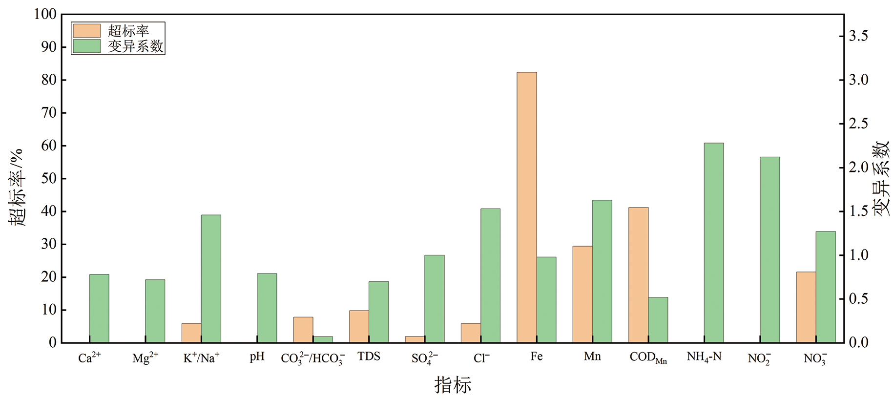
图3 监测指标统计学分析
Fig.3 Statistical analysis of monitoring indicators

图4 辽东湾地下水Extended Durov图
Fig.4 Extended Durov diagram for groundwater in Liaodong Bay

图5 相关性分析 a—下辽河平原区;b—辽东沿渤海诸河山丘区;c—辽西沿渤海诸河山丘区。
Fig.5 Correlation analysis
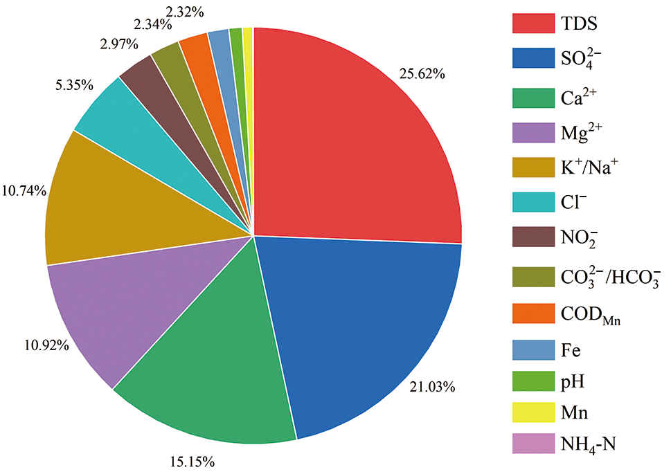
图6 地下水化学指标相对重要性排序
Fig.6 Ranking of relative importance for groundwater chemical indicators
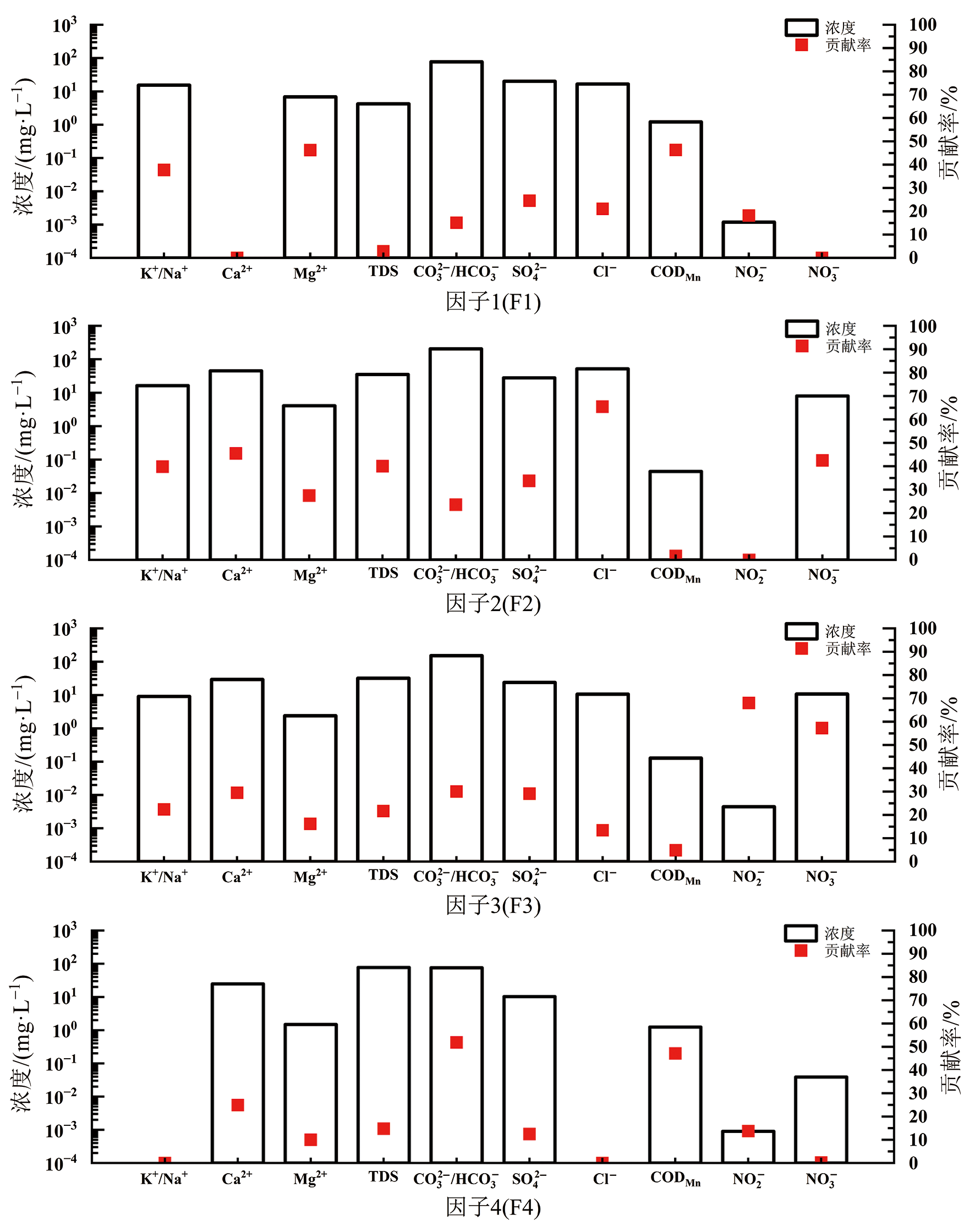
图7 PMF源成分谱
Fig.7 PMF source profiles
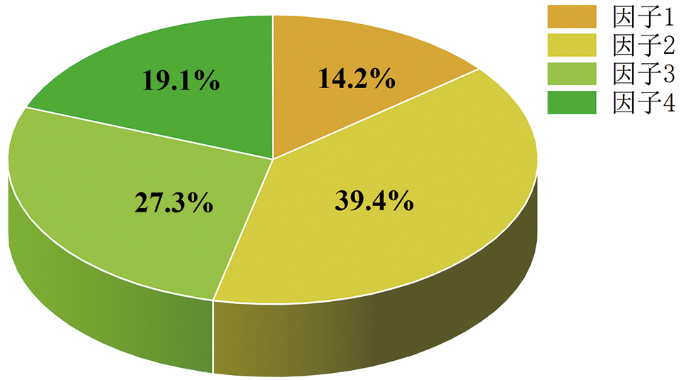
图8 源解析主要因子占比
Fig.8 Proportion of major factors in source apportionment
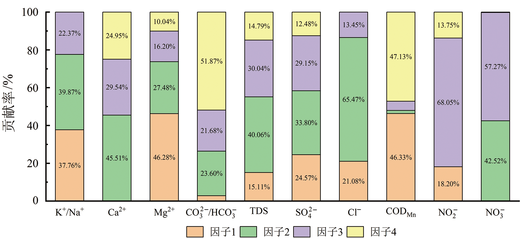
图9 主要因子对水质指标贡献率
Fig.9 Contribution rate of major factors to water quality indicators
| [1] | 刘玉莲, 李捷, 姜颖, 等. 地下水硝酸盐污染研究热点与趋势分析[J]. 水文地质工程地质, 2024, 51(5): 221-230. |
| [2] | MOOSAVIRAD S M, JANARDHANA M R, et al. Impact of anthropogenic activities on the chemistry and quality of groundwater: a case study from a terrain near Zarand City, Kerman Province, SE Iran[J]. Environmental Earth Sciences, 2013, 69(7): 2451-2467. |
| [3] | 徐文瑾. 辽宁省地下水污染风险评价[D]. 大连: 辽宁师范大学, 2019. |
| [4] | 曹益, 李逸凡, 周传富, 等. 武汉蔡甸区浅层地下水氮污染来源识别及其迁移转化过程解析[J]. 地质科技通报, 2025, 44(1): 262-273. |
| [5] | PANAGIOTOU C F, KYRIAKIDIS P, TZIRITIS E. Application of geostatistical methods to groundwater salinization problems: a review[J]. Journal of Hydrology, 2022, 615(Part A): 128566. |
| [6] | 薛佩佩, 文章, 梁杏. 地质统计学在含水层参数空间变异研究中的应用进展与发展趋势[J]. 地质科技通报, 2022, 41(1): 209-222. |
| [7] |
褚宴佳, 何宝南, 陈珍, 等. 基于随机森林模型识别浅层地下水TDS异常的方法研究[J]. 地学前缘, 2025, 32(2): 456-468.
DOI |
| [8] | XUAN Y X, LIU G L, ZHANG Y Z, et al. Factor affecting nitrate in a mixed land-use watershed of southern China based on dual nitrate isotopes, sources or transformations?[J]. Journal of Hydrology, 2022, 604: 127220. |
| [9] | 冉泽宇, 贾永锋, 姜永海, 等. 地下水污染源解析方法研究进展[J]. 地质通报, 2024, 43(1): 153-162. |
| [10] | 张可, 范存良, 姜先桥, 等. 冀东平原区浅层地下水金属来源分析与环境健康风险评价[J/OL]. 岩矿测试, 1-15(2024-11-21)[2025-04-30]. https://doi.org/10.15898/j.ykcs.202408310175. |
| [11] | 张晓瑜, 曾妍妍, 周金龙, 等. 巴伊盆地平原区地下水氟的分布、来源及富集成因[J]. 环境科学, 2025, 46(5): 2745-2756. |
| [12] | LI Q, LI P, ELUMALAI V. Identification and apportionment of groundwater pollution sources in the Guanzhong region based on PMF model[J]. Human and Ecological Risk Assessment: an International Journal, 2024, 31(1/2): 30-52. |
| [13] | HAGHNAZAR H, JOHANNESSON K H, GONZÁLEZ-PINZÓN R, et al. Groundwater geochemistry, quality, and pollution of the largest lake basin in the Middle East: comparison of PMF and PCA-MLR receptor models and application of the source-oriented HHRA approach[J]. Chemosphere, 2022, 288(Part 1): 132489. |
| [14] | MENNEKES D, RINDERER M, SEEGER S, et al. Ecohydrological travel times derived from in situ stable water isotope measurements in trees during a semicontrolled pot experiment[J]. Hydrology and Earth System Sciences, 2021, 25(8): 4513-4530. |
| [15] | ZUO R, HAN K, XU D H, et al. Response of environmental factors to attenuation of toluene in vadose zone[J]. Journal of Environmental Management, 2022, 302(Part A): 113968. |
| [16] | KEXUE H, RUI Z, DONGHUI X, et al. Quantitative expression of LNAPL pollutant concentrations in capillary zone by coupling multiple environmental factors based on random forest algorithm[J]. Journal of Hazardous Materials, 2024, 479: 135695. |
| [17] | 郭涛, 陈海洋, 滕彦国, 等. 东北典型农产区流域地下水水质评价与污染源识别[J]. 北京师范大学学报(自然科学版), 2017, 53(3): 316-322. |
| [18] | 郭晓东, 王晓光, 刘强, 等. 松花江-辽河流域地下水资源及其生态环境问题[J]. 中国地质, 2021, 48(4): 1062-1074. |
| [19] | 方敏. 三江平原松花江-挠力河流域浅层地下水“三氮”污染形成过程研究[D]. 长春: 吉林大学, 2019. |
| [20] | HAO A, ZHANG Y, ZHANG E, et al. Review: groundwater resources and related environmental issues in China[J]. Hydrogeology Journal, 2018, 26(5): 1325-1337. |
| [21] | 王昕康. 下辽河平原南部深层地下水水质与脆弱性评价研究[D]. 长春: 吉林大学, 2024. |
| [22] | 祁晓红. 大辽河营口段地下水水质变化趋势分析[J]. 水利科学与寒区工程, 2023, 6(2): 68-70. |
| [23] | 孟利, 左锐, 王金生, 等. 基于PCA-APCS-MLR 的地下水污染源定量解析研究[J]. 中国环境科学, 2017, 37(10): 3773-3786. |
| [24] | WANG X, XIAO C, YANG W, et al. Analysis of the quality, source identification and apportionment of the groundwater in a typical arid and semi-arid region[J]. Journal of Hydrology, 2023, 625(Part B): 130169. |
| [25] | 张桂成, 孙军. 渤海环境污染现状及研究进展[J]. 环境化学, 2023, 42(3): 918-930. |
| [26] | 冷佩芳, 李发东, 古丛珂, 等. 基于集成分析的环渤海地区河流硝酸盐污染解析[J]. 环境科学学报, 2018, 38(4): 1537-1548. |
| [27] | 张媛媛, 刘建卫, 田晶, 等. 辽东湾北部河流氮磷入海通量及污染源解析[J]. 水资源与水工程学报, 2024, 35(4): 29-37, 46. |
| [28] | 张广帅, 闫吉顺, 吴婷婷, 等. 辽东湾近岸海域开发利用对海水环境质量的影响[J]. 海洋环境科学, 2021, 40(6): 947-954. |
| [29] | ZHANG Y, WU J, SONG L, et al. Source apportionment and ecological risk assessment of PAHsin surface sediments from the Liaodong Bay, northern China[J]. Acta Oceanologica Sinica, 2018, 37(4): 12-21. |
| [30] | 王忠蕾. 1.2 Ma以来辽东湾北部沉积记录及其源汇过程研究[D]. 南京: 南京师范大学, 2021. |
| [31] | NEMBHARD H B. Index-applying contemporary statistical techniques[J]. Technometrics, 2004, 46(4): 490-491. |
| [32] |
MANSSON R, TSAPOGAS P, AKERLUND M, et al. Pearson correlation analysis of microarray data allows for the identification of genetic targets for early B-cell factor[J]. Journal of Biological Chemistry, 2004, 279(17): 17905-13.
DOI PMID |
| [33] | MORADPOUR S, ENTEZARI M, AYOUBI S, et al. Digital exploration of selected heavy metals using Random Forest and a set of environmental covariates at the watershed scale[J]. Journal of Hazardous Materials, 2023, 455: 131609. |
| [34] | BREIMAN L. Random forests[J]. Machine Learning, 2001, 45(1): 5-32. |
| [35] | AMIT Y, DONALD G. Shape quantization and recognition with randomized trees[J]. Neural Computation, 2006, 9(7): 1545-1588. |
| [36] | FENG H N, JU Y, YIN X F, et al. STLBRF: an improved random forest algorithm based on standardized-threshold for feature screening of gene expression data[J]. Briefings in Functional Genomics, 2024, 24: elae048. |
| [37] | BERNARD S, ADAM S, HEUTTE L. Dynamic random forests[J]. Pattern Recognition Letters, 2012, 33(12): 1580-1586. |
| [38] | PAATERO P, TAPPER U. Positive matrix factorization: a non-negative factor model with optimal utilization of error estimates of data values[J]. Environmetrics, 1994, 5(2): 111-126. |
| [39] | 马常莲, 周金龙, 曾妍妍, 等. 新疆若羌县绿洲带地下水重金属来源解析及健康风险评价[J]. 环境科学学报, 2023, 43(2): 266-277. |
| [40] | 王大伟, 李滢滢, 蒋一兰, 等. 垃圾渗滤液的过硫酸盐高级氧化深度处理技术研究进展[J]. 环境工程, 2025, 43(3): 42-56. |
| [41] | 陈方方, 古创, 孔芹, 等. 精馏脱氮处理垃圾填埋场渗滤液工程案例[J]. 中国给水排水, 2025, 41(2): 110-114. |
| [42] |
王辉, 栾维新, 康敏捷. 渤海氮污染的来源结构与污染压力空间分布[J]. 地理研究, 2020, 39(1): 186-199.
DOI |
| [43] | 聂华欣. 辽东湾近海污染问题与治理研究[D]. 大连: 大连海洋大学, 2022. |
| [44] | HOU W L, CHEN X, WU J C H. Sources and spatiotemporal variations of nitrogen and phosphorus in Liaodong Bay, China[J]. Marine Pollution Bulletin, 2022, 185(Part A): 114191. |
| [45] | 范祖金, 魏兴, 周育琳, 等. 典型山地农业区浅层地下水硝酸盐来源及转化过程解析[J]. 环境科学研究, 2023, 36(10): 1946-1956. |
| [46] | 刘大为. 辽河-大凌河三角洲四百年来的演化研究[D]. 北京: 中国地质大学(北京), 2019. |
| [47] | 王震宇, 吴昌志, 季峻峰, 等. 基性岩油气储层的CO2封存潜力及可行性初探: 以下辽河坳陷青龙台辉绿岩油气藏为例[J]. 第四纪研究, 2011, 31(3): 473-482. |
| [1] | 孔春芳, 田倩, 刘健, 蔡国荣, 赵杰, 徐凯. 基于集成学习模型与贝叶斯优化算法的成矿预测[J]. 地学前缘, 2025, 32(4): 122-139. |
| [2] | 肖凡, 杨华清, 唐奥, 黄旋财, 王翠翠. 基于机器学习与多源数据融合的东天山戈壁沙漠覆盖区中-酸性侵入岩岩性填图[J]. 地学前缘, 2025, 32(4): 199-212. |
| [3] | 简富源, 张子鸣, 董岳霖, 张文璟, 郝风云, 王一鸣, 王宇, 张振杰. 基于多重分形与随机森林的新疆哈巴河金矿成矿预测[J]. 地学前缘, 2025, 32(4): 78-94. |
| [4] | 黄毅, 董璇, 马志远, 田西昭, 朱帅, 朱云. 华北地区典型城市水体中内分泌干扰物酚类化合物赋存特征及风险评价[J]. 地学前缘, 2025, 32(4): 353-362. |
| [5] | 黄诗雯, 夏绮文, 何江涛, 何宝南, 陈翠柏, 孙继朝. 华北平原浅层地下水碘的分区特征及成因研究[J]. 地学前缘, 2025, 32(4): 510-522. |
| [6] | 张学航, 何宝南, 何江涛, 马硕, 刘菲, 杨珊珊, 史芫芫, 何炜, 杨白驹. 永定河回补区地下水污染风险演化研究[J]. 地学前缘, 2025, 32(4): 523-536. |
| [7] | 谌宏伟, 朱智超, 李正最, 喻娓厚, 周慧, 于莎莎, 彭向训. 极端气候下洞庭湖河水-地下水相互作用:以资江洞庭湖河段为例[J]. 地学前缘, 2025, 32(2): 445-455. |
| [8] | 褚宴佳, 何宝南, 陈珍, 何江涛. 基于随机森林模型识别浅层地下水TDS异常的方法研究[J]. 地学前缘, 2025, 32(2): 456-468. |
| [9] | 王威, 程行, 高旭波, 田振环, 刘春华, 武占辉, 李成城, 孔淑琼. 黄河三角洲地区地下水水质成因研究:以山东省东营市孤岛镇为例[J]. 地学前缘, 2025, 32(2): 469-483. |
| [10] | 钟林健, 郭朝晖, 谢慧民, 黄驰岳, 高梓伦, 梁学超, 徐锐. 地下水位对尾矿中重金属释放及其在土壤中吸附的影响研究[J]. 地学前缘, 2025, 32(2): 484-494. |
| [11] | 欧阳恺皋, 蒋小伟, 杜亚楠, 张志远, 韩鹏飞, 吴业楠, 王旭升. 华北“23·7”强降雨事件对不同埋深地下水的补给机理:以雄安新区为例[J]. 地学前缘, 2025, 32(1): 432-439. |
| [12] | 何佳汇, 毛海如, 薛洋, 廖福, 高柏, 饶志, 杨扬, 刘媛媛, 王广才. 赣抚平原东北部地下水硝酸盐浓度变化特征及成因[J]. 地学前缘, 2024, 31(3): 360-370. |
| [13] | 付宇, 曹文庚, 张春菊, 翟文华, 任宇, 南天, 李泽岩. 基于集成学习优化的河套盆地地下水砷风险评估[J]. 地学前缘, 2024, 31(3): 371-380. |
| [14] | 杨冰, 孟童, 郭华明, 连国玺, 陈帅瑶, 杨曦. 基于Kd的某酸法地浸铀矿山地下水铀运移模拟[J]. 地学前缘, 2024, 31(3): 381-391. |
| [15] | 丁祥, 袁贝, 杜平, 刘虎鹏, 张云慧, 陈娟. 典型矿冶城市土壤重金属累积驱动因子研究和概率风险评估[J]. 地学前缘, 2024, 31(2): 31-41. |
| 阅读次数 | ||||||
|
全文 |
|
|||||
|
摘要 |
|
|||||