地学前缘 ›› 2025, Vol. 32 ›› Issue (4): 199-212.DOI: 10.13745/j.esf.sf.2025.4.54
肖凡1,2,3( ), 杨华清1, 唐奥1, 黄旋财1, 王翠翠4
收稿日期:2024-08-05
修回日期:2025-02-19
出版日期:2025-07-25
发布日期:2025-08-04
作者简介:肖 凡(1985—),男,博士,副教授,博士生导师,主要从事矿产普查与勘探和数学地质方面的教学与科研工作。E-mail: xiaofan3@mail.sysu.edu.cn
基金资助:
XIAO Fan1,2,3(), YANG Huaqing1, TANG Ao1, HUANG Xuancai1, WANG Cuicui4
Received:2024-08-05
Revised:2025-02-19
Online:2025-07-25
Published:2025-08-04
摘要:
东天山地区矿产资源丰富,构造演化复杂,出露大面积的中-酸性侵入岩,它们主要形成于晚古生代,与区域构造演化和内生金属矿床成矿关系十分密切,对区域构造环境和成矿规律的认识具有重要意义。然而,由于覆盖层的遮蔽作用,覆盖区内中-酸性侵入岩的地质填图信息是不完整或完全缺失的,这在一定程度上制约了东天山区域构造与成矿规律的认识。近年来,基于大数据研究新范式发展起来的融合地球物理、地球化学、遥感图像等多源探测数据进行间接岩性填图的方法,为解决这一难题提供了有效途径。机器学习算法被诸多实例证明是数据融合的有力工具,它对复杂非线性地学数据的分类和判别等问题具有较强的适用性。为此,本文提出利用机器学习方法融合重力、航磁、地球化学、遥感影像数据,快速、经济、更准确地进行东天山地区中-酸性侵入岩的填图工作。对研究区内出露的中-酸性侵入岩进行类别标定并将其作为目标变量,将布格重力、航磁、水系沉积物地球化学和Landsat卫星多波段遥感影像数据作为预测变量,采用合成少数类过采样技术,解决岩性样本数据分布不均衡问题。基于随机森林和人工神经网络算法,对超参数进行网格搜索得到最优预测模型,分别对东天山地区覆盖区内隐伏中-酸性岩体的空间分布和岩性进行预测,并对预测结果进行对比分析和讨论。准确率、召回率和F1得分都表明随机森林模型优于人工神经网络模型,故最终选取随机森林模型的预测结果作为东天山覆盖区的中-酸性侵入岩岩性填图的最终结果,进一步讨论了中-酸性侵入岩的空间分布对区域构造和成矿作用的控制规律。相比于传统的人工地质填图方式,基于机器学习和多源数据融合的间接岩性填图方法具有效率高、成本较低廉和不受地质地理景观条件制约等优点。
中图分类号:
肖凡, 杨华清, 唐奥, 黄旋财, 王翠翠. 基于机器学习与多源数据融合的东天山戈壁沙漠覆盖区中-酸性侵入岩岩性填图[J]. 地学前缘, 2025, 32(4): 199-212.
XIAO Fan, YANG Huaqing, TANG Ao, HUANG Xuancai, WANG Cuicui. Lithological mapping of intermediate-acid intrusive rocks in the Eastern Tianshan Gobi-desert covered area using machine learning for multisource data fusion[J]. Earth Science Frontiers, 2025, 32(4): 199-212.

图1 东天山大地构造位置、构造单元划分及地质简图(a据文献[16]修改;b引自文献[19])
Fig.1 The tectonic location, structural units, and simplified geological map of the Eastern Tianshan. (a) modified after [16] and (b) adapted from [19].
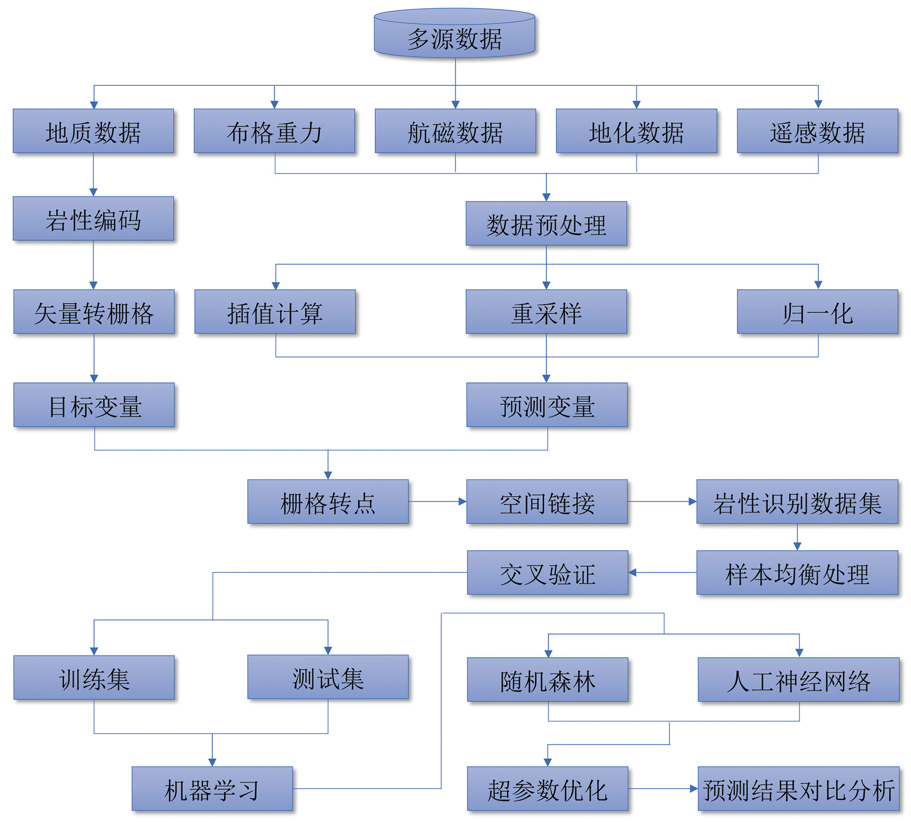
图2 基于机器学习与多源数据融合的岩性填图方法
Fig.2 The lithological mapping method based on machine learning and multi-source data fusion

图3 随机森林算法
Fig.3 The algorithm of random forest

图4 人工神经网络模型
Fig.4 The artificial neural network model
| 岩性名称 | 类别编码 | 样本数量 |
|---|---|---|
| 二长花岗岩 | 1 | 1 440 |
| 花岗闪长岩 | 2 | 417 |
| 黑云母花岗岩 | 3 | 20 |
| 闪长岩 | 4 | 243 |
| 石英斑岩 | 5 | 54 |
| 英云闪长岩 | 6 | 120 |
| 石英闪长岩 | 7 | 27 |
| 正长花岗岩 | 8 | 250 |
| 花岗斑岩 | 9 | 44 |
| 石英正长岩 | 10 | 25 |
| 花岗岩 | 11 | 135 |
| 石英二长岩 | 12 | 21 |
| 英安斑岩 | 13 | 10 |
| 其他岩类 | 14 | 7 455 |
表1 岩性类别编码
Table 1 Lithological category labeling
| 岩性名称 | 类别编码 | 样本数量 |
|---|---|---|
| 二长花岗岩 | 1 | 1 440 |
| 花岗闪长岩 | 2 | 417 |
| 黑云母花岗岩 | 3 | 20 |
| 闪长岩 | 4 | 243 |
| 石英斑岩 | 5 | 54 |
| 英云闪长岩 | 6 | 120 |
| 石英闪长岩 | 7 | 27 |
| 正长花岗岩 | 8 | 250 |
| 花岗斑岩 | 9 | 44 |
| 石英正长岩 | 10 | 25 |
| 花岗岩 | 11 | 135 |
| 石英二长岩 | 12 | 21 |
| 英安斑岩 | 13 | 10 |
| 其他岩类 | 14 | 7 455 |
| 参数名称 | 表示符号 | 测试值 | 最优值 |
|---|---|---|---|
| 决策树的数量 | EN | 200, 400, 600, ……, 2 600, 2 800, 3 000 | 1 600 |
| 决策树的最大深度 | Dmax | 50, 100, 150, ……, 400, 450, 500 | 200 |
| 最大分离特征数 | Fmax | 1, 3, 5, 7 | 7 |
| 最小分离样本数 | SSmin | 2, 5, 10 | 2 |
| 最小叶子节点样本数 | SLmin | 1, 2, 4, 8 | 1 |
表2 随机森林模型超参数优化结果
Table 2 Optimization results of hyperparameters in the random forest
| 参数名称 | 表示符号 | 测试值 | 最优值 |
|---|---|---|---|
| 决策树的数量 | EN | 200, 400, 600, ……, 2 600, 2 800, 3 000 | 1 600 |
| 决策树的最大深度 | Dmax | 50, 100, 150, ……, 400, 450, 500 | 200 |
| 最大分离特征数 | Fmax | 1, 3, 5, 7 | 7 |
| 最小分离样本数 | SSmin | 2, 5, 10 | 2 |
| 最小叶子节点样本数 | SLmin | 1, 2, 4, 8 | 1 |
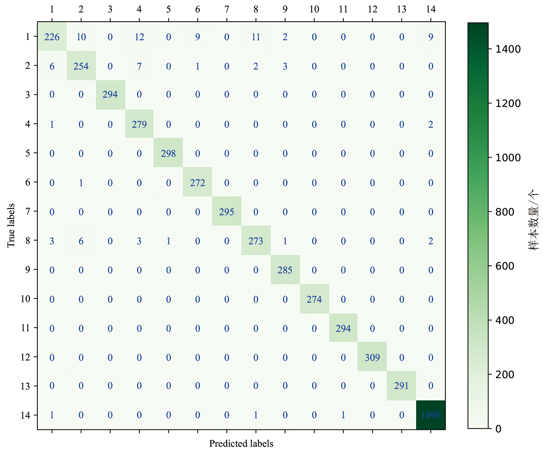
图5 随机森林预测结果混淆矩阵
Fig.5 The confusion matrix of the prediction results derived from the random forest
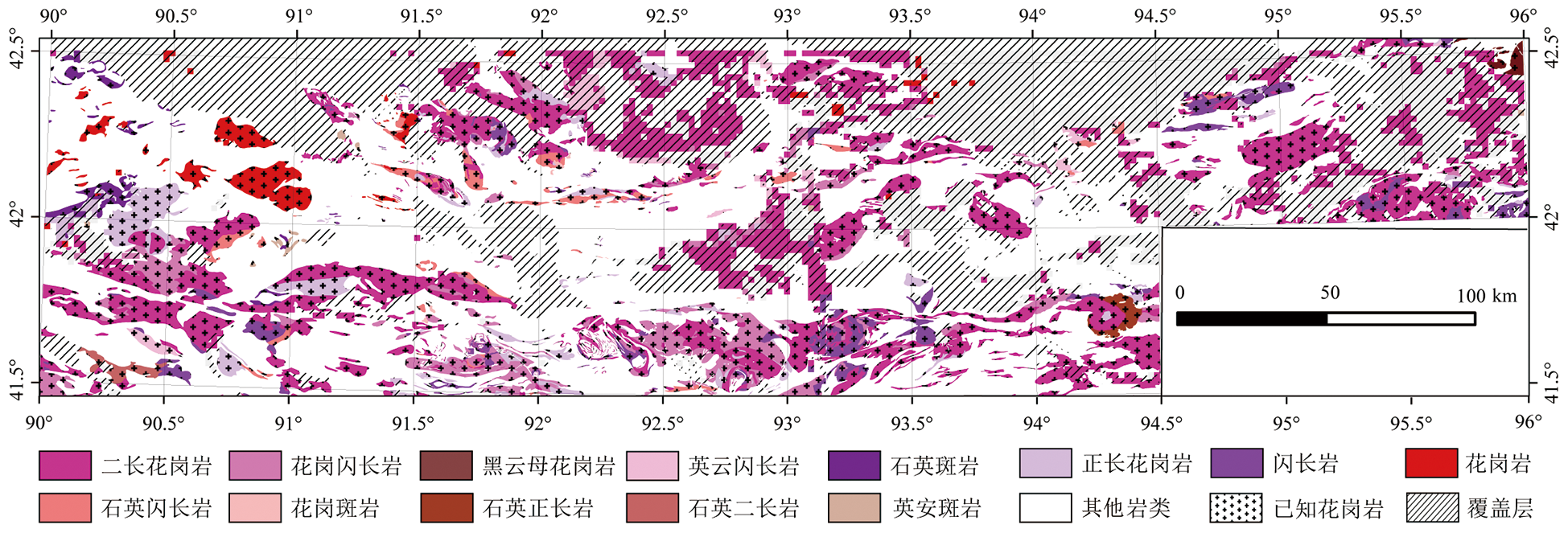
图6 随机森林岩性填图结果
Fig.6 The lithological mapping results using the random forest
| 类别 | 准确率/% | 召回率/% | F1得分/% |
|---|---|---|---|
| 1 | 95 | 81 | 88 |
| 2 | 94 | 93 | 93 |
| 3 | 100 | 100 | 100 |
| 4 | 93 | 99 | 96 |
| 5 | 100 | 100 | 100 |
| 6 | 96 | 100 | 98 |
| 7 | 100 | 100 | 100 |
| 8 | 95 | 94 | 95 |
| 9 | 98 | 100 | 99 |
| 10 | 100 | 100 | 100 |
| 11 | 100 | 100 | 100 |
| 12 | 100 | 100 | 100 |
| 13 | 100 | 100 | 100 |
| 14 | 99 | 100 | 99 |
表3 随机森林预测结果性能指标值
Table 3 Performance metrics for the prediction result derived by the random forest
| 类别 | 准确率/% | 召回率/% | F1得分/% |
|---|---|---|---|
| 1 | 95 | 81 | 88 |
| 2 | 94 | 93 | 93 |
| 3 | 100 | 100 | 100 |
| 4 | 93 | 99 | 96 |
| 5 | 100 | 100 | 100 |
| 6 | 96 | 100 | 98 |
| 7 | 100 | 100 | 100 |
| 8 | 95 | 94 | 95 |
| 9 | 98 | 100 | 99 |
| 10 | 100 | 100 | 100 |
| 11 | 100 | 100 | 100 |
| 12 | 100 | 100 | 100 |
| 13 | 100 | 100 | 100 |
| 14 | 99 | 100 | 99 |
| 隐藏层数 | 每层测试节点数 | 最优节点数 | 平均准确率/% |
|---|---|---|---|
| 1 | [50, 250, 450,650] | [50] | 88.23 |
| 2 | [50, 250, 450,650] | [450, 50] | 88.59 |
| 3 | [50, 250, 450,650] | [450, 650, 650] | 90.39 |
| 4 | [50, 250, 450,650] | [250, 50, 250, 250] | 89.09 |
表4 人工神经网络模型超参数优化结果
Table 4 Optimization results of hyperparameters in the artificial neural network
| 隐藏层数 | 每层测试节点数 | 最优节点数 | 平均准确率/% |
|---|---|---|---|
| 1 | [50, 250, 450,650] | [50] | 88.23 |
| 2 | [50, 250, 450,650] | [450, 50] | 88.59 |
| 3 | [50, 250, 450,650] | [450, 650, 650] | 90.39 |
| 4 | [50, 250, 450,650] | [250, 50, 250, 250] | 89.09 |

图7 人工神经网络预测结果混淆矩阵
Fig.7 The confusion matrix of the prediction results derived by the artificial neural network

图8 人工神经网络岩性填图结果
Fig.8 The lithological mapping results using the artificial neural network
| 类别 | 准确率/% | 召回率/% | F1得分/% |
|---|---|---|---|
| 1 | 96 | 96 | 96 |
| 2 | 74 | 41 | 53 |
| 3 | 98 | 93 | 95 |
| 4 | 82 | 79 | 80 |
| 5 | 87 | 95 | 91 |
| 6 | 93 | 88 | 90 |
| 7 | 55 | 72 | 62 |
| 8 | 97 | 100 | 99 |
| 9 | 80 | 80 | 80 |
| 10 | 97 | 100 | 99 |
| 11 | 90 | 96 | 93 |
| 12 | 97 | 100 | 99 |
| 13 | 97 | 100 | 98 |
| 14 | 97 | 98 | 98 |
表5 人工神经网络预测结果性能指标值
Table 5 Performance metrics for the prediction result derived by the artificial neural network
| 类别 | 准确率/% | 召回率/% | F1得分/% |
|---|---|---|---|
| 1 | 96 | 96 | 96 |
| 2 | 74 | 41 | 53 |
| 3 | 98 | 93 | 95 |
| 4 | 82 | 79 | 80 |
| 5 | 87 | 95 | 91 |
| 6 | 93 | 88 | 90 |
| 7 | 55 | 72 | 62 |
| 8 | 97 | 100 | 99 |
| 9 | 80 | 80 | 80 |
| 10 | 97 | 100 | 99 |
| 11 | 90 | 96 | 93 |
| 12 | 97 | 100 | 99 |
| 13 | 97 | 100 | 98 |
| 14 | 97 | 98 | 98 |

图9 随机森林和人工神经网络预测结果性能指标对比 a—准确率; b—召回率; c—F1得分。
Fig.9 Comparison of prediction results between the random forest and the artificial neural network using (a) accuracy, (b) recall, and (c) F1-scores
| [1] | 陈建平, 吕鹏, 吴文, 等. 基于三维可视化技术的隐伏矿体预测[J]. 地学前缘, 2007, 14(5): 54-62. |
| [2] | 成秋明. 覆盖区矿产综合预测思路与方法[J]. 地球科学: 中国地质大学学报, 2012, 37(6): 1109-1125. |
| [3] | GONZÁLEZ-ÁLVAREZ I, BONI M, ANAND R R. Mineral exploration in regolith-dominated terrains: global considerations and challenges[J]. Ore Geology Reviews, 2016, 73: 375-379. |
| [4] | 毛先成, 邓浩, 陈进, 等. 金属矿山深部资源三维智能预测理论与方法[J]. 矿产勘查, 2024, 15(8): 1365-1378. |
| [5] |
唐利, 张寿庭, 王亮, 等. 浅覆盖区隐伏萤石矿找矿预测: 以内蒙古赤峰俄力木台为例[J]. 地学前缘, 2021, 28(3): 208-220.
DOI |
| [6] |
夏庆霖, 赵梦余, 王孝臣, 等. 基于地质异常的内蒙古新达来草原覆盖区钼铜多金属矿产定量预测[J]. 地学前缘, 2021, 28(3): 56-66.
DOI |
| [7] | 肖凡. 覆盖区区域矿产资源评价方法研究:以东天山戈壁沙漠区“土屋式” 斑岩铜(钼)矿为例[D]. 武汉: 中国地质大学(武汉), 2013. |
| [8] | 肖克炎, 孙莉, 阴江宁, 等. 全国重要矿产预测评价[J]. 地球学报, 2014, 35(5): 543-551. |
| [9] | CHEN X J, SHU L S, SANTOSH M, et al. Island arc-type bimodal magmatism in the eastern Tianshan Belt, Northwest China: geochemistry, zircon U-Pb geochronology and implications for the Paleozoic crustal evolution in Central Asia[J]. Lithos, 2013, 168: 48-66. |
| [10] | 韩春明, 肖文交, 万博, 等. 东天山晚古生代-中生代构造演化和内生金属矿床成矿系列[J]. 岩石学报, 2018, 34(7): 1914-1932. |
| [11] | DU L, LONG X P, YUAN C, et al. Tracing the subduction and accretion history of the trench-arc-basin system in the Chinese Eastern Tianshan: insights from Paleozoic magmatic and crustal evolution[J]. Earth-Science Reviews, 2024, 252: 104761. |
| [12] | WANG Y F, CHEN H Y, FALLOON T J, et al. The Paleozoic-Mesozoic magmatic evolution of the eastern Tianshan, NW China: constraints from geochronology and geochemistry of the Sanchakou intrusive complex[J]. Gondwana Research, 2022, 103: 1-22. |
| [13] | 王中刚, 朱笑青, 毕华, 等. 中国新疆花岗岩[M]. 北京: 地质出版社, 2006. |
| [14] | XIAO W J, ZHANG L C, QIN K Z, et al. Paleozoic accretionary and collisional tectonics of the eastern Tianshan (China): implications for the continental growth of central Asia[J]. American Journal of Science, 2004, 304(4): 370-395. |
| [15] | YANG H, XIAO W J, MAO Q G, et al. Two episodes of extension induced by slab rollback and root foundering in the EasternTianshan, southwestern Altaids: insights from granites and intermediate dykes[J]. Lithos, 2024, 476: 107616. |
| [16] | XIAO F, WANG K Q, HOU W S, et al. Prospectivity mapping for porphyry Cu-Mo mineralization in the eastern Tianshan, Xinjiang, northwestern China[J]. Natural Resources Research, 2020, 29(1): 89-113. |
| [17] | CHENG Q M. Singularity theory and methods for mapping geochemical anomalies caused by buried sources and for predicting undiscovered mineral deposits in covered areas[J]. Journal of Geochemical Exploration, 2012, 122: 55-70. |
| [18] | 胡健民, 陈虹, 邱士东, 等. 覆盖区区域地质调查(1∶50000)思路、 原则与方法[J]. 地球科学, 2020, 45(12): 4291-4312. |
| [19] | XIAO F, WANG Z H. Geological interpretation of Bouguer gravity and aeromagnetic data from the Gobi-desert covered area, Eastern Tianshan, China: implications for porphyry Cu-Mo polymetallic deposits exploration[J]. Ore Geology Reviews, 2017, 80: 1042-1055. |
| [20] | ZHAO J, WANG W L, DONG L H, et al. Application of geochemical anomaly identification methods in mapping of intermediate and felsic igneous rocks in eastern Tianshan, China[J]. Journal of Geochemical Exploration, 2012, 122: 81-89. |
| [21] | TEHRANI F S, CALVELLO M, LIU Z Q, et al. Machine learning and landslide studies: recent advances and applications[J]. Natural Hazards, 2022, 114(2): 1197-1245. |
| [22] | SUN K, CHEN Y S, GENG G S, et al. A review of mineral prospectivity mapping using deep learning[J]. Minerals, 2024, 14(10): 1021. |
| [23] |
MA L, LIU Y, ZHANG X L, et al. Deep learning in remote sensing applications: a meta-analysis and review[J]. ISPRS Journal of Photogrammetry and Remote Sensing, 2019, 152: 166-177.
DOI |
| [24] | ZHOU W S, LIU C, LIU Y D, et al. Machine learning in reservoir engineering:a review[J]. Processes, 2024, 12(6): 1219. |
| [25] | ALI EL-OMAIRI M, EL GAROUANI A. A review on advancements in lithological mapping utilizing machine learning algorithms and remote sensing data[J]. Heliyon, 2023, 9(9): e20168. |
| [26] | ADELI A, EMERY X. Geostatistical simulation of rock physical and geochemical properties with spatial filtering and its application to predictive geological mapping[J]. Journal of Geochemical Exploration, 2021, 220: 106661. |
| [27] | ASKARI G, POUR A B, PRADHAN B, et al. Band ratios matrix transformation (BRMT):a sedimentary lithology mapping approach using ASTER satellite sensor[J]. Sensors, 2018, 18(10): 3213. |
| [28] | GE Y Z, ZHANG Z J, CHENG Q M, et al. Geological mapping of basalt using stream sediment geochemical data: case study of covered areas in Jining, Inner Mongolia, China[J]. Journal of Geochemical Exploration, 2022, 232: 106888. |
| [29] | CHEN L, ZHANG NN, CHANG J Y, et al. Indicator element selection and lithological mapping using deep learning methods in the Dahongliutan area, NW China[J]. Journal of Geochemical Exploration, 2025, 268: 107611. |
| [30] | CRACKNELL M J, READING A M. Geological mapping using remote sensing data:a comparison of five machine learning algorithms, their response to variations in the spatial distribution of training data and the use of explicit spatial information[J]. Computers and Geosciences, 2014, 63: 22-33. |
| [31] | RADFORD D D G, CRACKNELL M J, ROACH M J, et al. Geological mapping in western Tasmania using radar and random forests[J]. IEEE Journal of Selected Topics in Applied Earth Observations and Remote Sensing, 2018, 11(9): 3075-3087. |
| [32] | DONG Y N, YANG ZZ, LIU Q W, et al. Fusion of GaoFen-5 and Sentinel-2B data for lithological mapping using vision transformer dynamic graph convolutional network[J]. International Journal of Applied Earth Observation and Geoinformation, 2024, 129: 103780. |
| [33] | 冀全伟, 王文磊, 刘治博, 等. 一种基于机器学习算法的岩性填图方法[J]. 地质力学学报, 2021, 27(3): 339-349. |
| [34] | LI C L, LI F D, LIU C, et al. Deep learning-based geological map generation using geological routes[J]. Remote Sensing of Environment, 2024, 309: 114214. |
| [35] | MANAP H S, SAN B T. Data integration for lithological mapping using machine learning algorithms[J]. Earth Science Informatics, 2022, 15(3): 1841-1859. |
| [36] | OTHMAN A A, GLOAGUEN R. Integration of spectral, spatial and morphometric data into lithological mapping: a comparison of different Machine Learning Algorithms in the Kurdistan Region, NE Iraq[J]. Journal of Asian Earth Sciences, 2017, 146: 90-102. |
| [37] | WANG S, HUANG X H, HAN W, et al. Lithological mapping of geological remote sensing via adversarial semi-supervised segmentation network[J]. International Journal of Applied Earth Observation and Geoinformation, 2023, 125: 103536. |
| [38] | WANG W L, XUE CC, ZHAO J, et al. Machine learning-based field geological mapping: a new exploration of geological survey data acquisition strategy[J]. Ore Geology Reviews, 2024, 166: 105959. |
| [39] | YANG L, SHAMI A. On hyperparameter optimization of machine learning algorithms: theory and practice[J]. Neurocomputing, 2020, 415: 295-316. |
| [40] | BREIMAN L. Random forests[J]. Machine Learning, 2001, 45(1): 5-32. |
| [41] | CHEN MM, XIAO F. Projection pursuit random forest for mineral prospectivity mapping[J]. Mathematical Geosciences, 2023, 55: 963-987. |
| [42] | BONACCORSO G. Machine Learning Algorithms[M]. Birmingham: Packt Publishing, 2018. |
| [43] | BRASPENNING P J, THUIJSMAN F, WEIJTERS A J M M. Artificial Neural Networks[M]. Berlin, Heidelberg: Springer, 1995. |
| [44] | CHAWLA N V, BOWYER K W, HALL L O, et al. SMOTE: synthetic minority over-sampling technique[J]. Journal of Artificial Intelligence Research, 2002, 16: 321-357. |
| [45] | XIAO F, CHEN J G, AGTERBERG F, et al. Element behavior analysis and its implications for geochemical anomaly identification:a case study for porphyry Cu-Mo deposits in Eastern Tianshan, China[J]. Journal of Geochemical Exploration, 2014, 145: 1-11. |
| [46] | PANIGRAHI N. Inverse distance weight[M]// DAYA SAGAR B S, CHENGQ M, MCKINLEYJ, et al. Encyclopedia of mathematical geosciences. Cham: Springer International Publishing, 2020: 1-7. |
| [47] | GE Y, JIN Y, STEIN A, et al. Principles and methods of scaling geospatial Earth science data[J]. Earth-Science Reviews, 2019, 197: 102897. |
| [48] | LU Y, YANG C B, HE R Z. Towards lithology mapping in semi-arid areas using time-series Landsat-8 data[J]. Ore Geology Reviews, 2022, 150: 105163. |
| [49] | ZHAO B, WU J J, YANG F, et al. A novel approach for extraction of Gaoshanhe-Group outcrops using Landsat Operational Land Imager (OLI) data in the heavily loess-covered Baoji District, Western China[J]. Ore Geology Reviews, 2019, 108: 88-100. |
| [50] | SINGH D, SINGH B. Investigating the impact of data normalization on classification performance[J]. Applied Soft Computing, 2020, 97: 105524. |
| [1] | 孔春芳, 田倩, 刘健, 蔡国荣, 赵杰, 徐凯. 基于集成学习模型与贝叶斯优化算法的成矿预测[J]. 地学前缘, 2025, 32(4): 122-139. |
| [2] | 叶舒婉, 侯卫生, 杨玠, 汪海城, 白芸, 王永志. 三维地质智能建模研究进展[J]. 地学前缘, 2025, 32(4): 182-198. |
| [3] | 肖克炎, 李程, 唐瑞, 王瑶, 孙莉, 柳炳利, 樊铭静. 大数据智能预测评价[J]. 地学前缘, 2025, 32(4): 20-37. |
| [4] | 张雨飞, 张杨, 吉俊杰, 成秋明. 基于机器学习方法的南海洋壳大地热流预测[J]. 地学前缘, 2025, 32(4): 235-249. |
| [5] | 简富源, 张子鸣, 董岳霖, 张文璟, 郝风云, 王一鸣, 王宇, 张振杰. 基于多重分形与随机森林的新疆哈巴河金矿成矿预测[J]. 地学前缘, 2025, 32(4): 78-94. |
| [6] | 李金明, 张杨, 成秋明. 基于机器学习与垂向分层建模联合驱动的华北克拉通地温梯度空间分布预测[J]. 地学前缘, 2025, 32(4): 291-302. |
| [7] | 徐东辉, 黎涛, 林艳竹, 陈添斐. 基于关联性监测指标的辽东湾地下水硝酸盐源解析[J]. 地学前缘, 2025, 32(4): 376-387. |
| [8] | 褚宴佳, 何宝南, 陈珍, 何江涛. 基于随机森林模型识别浅层地下水TDS异常的方法研究[J]. 地学前缘, 2025, 32(2): 456-468. |
| [9] | 张必敏, 王学求, 周建, 王玮, 刘汉粮, 刘东盛, Sounthone LAOLO, Phomsylalai SOUKSAN, 谢淼, 董春放, 柳青青, 鲁岳鑫, 王浩楠, 贺彬. 老挝铜资源成矿规律与基于机器学习的远景预测[J]. 地学前缘, 2025, 32(1): 61-77. |
| [10] | 张焕宝, 贺海洋, 杨仕教, 李亚林, 毕文军, 韩世礼, 郭钦鹏, 杜青. 基于机器学习的埃达克质岩构造背景判别研究[J]. 地学前缘, 2024, 31(4): 417-428. |
| [11] | 张利军, 鲁文豪, 张建东, 彭光雄, 卜建财, 唐凯, 谢渐成, 徐质彬, 杨海燕. 基于深度学习的镜下岩石、矿物薄片识别[J]. 地学前缘, 2024, 31(3): 498-510. |
| [12] | 谷浩, 杨泽强, 高猛, 唐相伟, 王东晓, 刘奎松, 杨树人, 郭跃闪, 王云, 王功文. 河南围山城金银矿集区三维地质建模与成矿预测[J]. 地学前缘, 2024, 31(3): 245-259. |
| [13] | 刘洋, 李三忠, 钟世华, 郭广慧, 刘嘉情, 牛警徽, 薛梓萌, 周建平, 董昊, 索艳慧. 机器学习:海底矿产资源智能勘探的新途径[J]. 地学前缘, 2024, 31(3): 520-529. |
| [14] | 苏恺明, 徐耀辉, 徐旺林, 张月巧, 白斌, 李阳, 严刚. 鄂尔多斯盆地延长组多油源贡献比例与分布规律:基于机器学习与可解释性研究[J]. 地学前缘, 2024, 31(3): 530-540. |
| [15] | 刘奇鑫, 顾行发, 王春梅, 杨健, 占玉林. 不同尺度的土壤含水量主被动微波联合反演方法研究[J]. 地学前缘, 2024, 31(2): 42-53. |
| 阅读次数 | ||||||
|
全文 |
|
|||||
|
摘要 |
|
|||||