地学前缘 ›› 2023, Vol. 30 ›› Issue (5): 334-357.DOI: 10.13745/j.esf.sf.2023.8.16
• “印度-欧亚大陆碰撞及其远程效应”专栏之九 • 上一篇 下一篇
张进1,2( ), 张北航3, 赵衡1,2, 云龙4, 曲军峰2, 王振义2, 杨亚琦5, 赵硕2
收稿日期:2023-08-01
修回日期:2023-08-16
出版日期:2023-09-25
发布日期:2023-10-20
作者简介:张 进(1973—),男,研究员,博士生导师,主要从事构造地质学研究。E-mail: zhangjinem@sina.com
基金资助:
ZHANG Jin1,2(), ZHANG Beihang3, ZHAO Heng1,2, YUN Long4, QU Junfeng2, WANG Zhenyi2, YANG Yaqi5, ZHAO Shuo2
Received:2023-08-01
Revised:2023-08-16
Online:2023-09-25
Published:2023-10-20
摘要:
北山-阿拉善地区位于中亚造山带中部,新生代晚期受控于印度-欧亚板块的碰撞,发生了不同程度的陆内变形,是青藏高原与蒙古高原应力传递区,是研究印度-欧亚碰撞远程效应的关键地区。北山-阿拉善地区晚新生代变形区别于中亚造山带西段的天山以及阿尔泰地区,表现为发育一系列近东西向的左行走滑断层及其间一系列北东向的正断层及其控制的断陷(拉分)盆地。近东西向的左行走滑断层规模较大,走向延伸很长,成为北山-阿拉善新生代晚期变形的骨干构造。整体上北山-阿拉善地区之间的晚新生代变形是在北侧北东东向南蒙古—天山左行走滑断层和南侧北东东向阿尔金断层之间阶区内的变形,在这个左行-左阶的区域内,变形表现为边界走滑断层派生出的近东西向次级走滑断层(P剪切)和北东向伸展盆地(如额济纳盆地和旧井盆地)。该区域是一个左行张剪区域,使得该区成为区别于蒙古戈壁阿尔泰的右行压剪构造,而阶区内区域性的伸展导致了本区平坦的地势并成为主要的汇水盆地区。GPS速度场以及上地幔-下地壳各向异性资料表明,塔里木克拉通在青藏高原向北的扩展过程中起重要作用,青藏高原北缘上地幔-下地壳在遇到塔里木克拉通后沿着该克拉通东南边缘转向,向北东流动,而塔里木本身则继续向北北东传递应力,导致天山的崛起并挤压准噶尔盆地,进而形成了阿尔泰山北北西走向的右行剪切变形;向北东方向流动的上地幔—下地壳则导致北山-阿拉善地区以及南蒙古地区的晚新生代左行剪切变形,该地区的变形宏观上呈现弥散性特点,区别于塔里木-天山-准噶尔地区新生代变形集中天山和阿尔泰山一带的现象。
中图分类号:
张进, 张北航, 赵衡, 云龙, 曲军峰, 王振义, 杨亚琦, 赵硕. 北山-阿拉善晚新生代变形的特征与机制[J]. 地学前缘, 2023, 30(5): 334-357.
ZHANG Jin, ZHANG Beihang, ZHAO Heng, YUN Long, QU Junfeng, WANG Zhenyi, YANG Yaqi, ZHAO Shuo. Late Cenozoic deformation characteristics and mechanism of the Beishan-Alxa region[J]. Earth Science Frontiers, 2023, 30(5): 334-357.

图1 南蒙古—青藏高原北侧活动构造(A)与地震分布(B)(活动断层分布和名称据文献[22⇓-24]) BDFS—Bogd断层系;TBFS—Töv-Bogd断层系;SMTFS—南蒙古-天山断层系;NTHF—吐哈盆地北缘断层;XDF—兴地断层;BAF—博罗科努—阿奇克库都克断层;QMF—且末断层;SWSF—三危山断层;JTNSF—金塔南山断层;MSLF—慕少梁断层;BDSF—北大山断层;TAYF—桃花拉山—阿右旗—雅布赖断层;XTF—香山—天景山断层; EHLF—贺兰山东麓断层;NESF—鄂尔多斯北缘断裂;LSDF—狼山—色尔腾山—大青山断层;NQLFS—北祁连断层系;NQDF—柴达木北缘断层;EKLF—东昆仑断层。
Fig.1 Active faults (A) and earthquakes (B) in the southern Mongolia and northern Qinghai-Tibetan Plateau regions. Modified from [22⇓-24].

图2 北山-阿拉善地区晚新生代断层分布
Fig.2 Late Cenozoic faults in the Beishan-Alxa region

图3 旧井盆地山前正断层地貌
Fig.3 Typical landforms formed by active normal faults along the eastern boundary of the Jiujing basin

图4 旧井盆地东缘山前活动正断层 A,B—前人开挖探槽;C—断层面上的斜滑擦痕;D—旧井盆地基底花岗糜棱岩。
Fig.4 Active normal faults along the eastern boundary of the Jiujing basin

图5 北山南部东涧泉—旧井地质图
Fig.5 Geological map of Dongjianquan-Jiujing region, southern Beishan

图6 鄂博庙断层地质图
Fig.6 Geological map of the Ebomiao fault zone

图7 鄂博庙断层特征 A—地表断层陡坎;B—ETC-03探槽西壁局部;C—ETC-03探槽西壁解释。U1—灰白、灰黄色砂砾石层;U2—棕黄色砂砾石层;U3-1—U2层顶部白色钙质淋滤结核;U3-2—棕黄色砂砾石层;U4—深棕黄色粗砂砾石层;U5—棕黄色砂砾石层,水平层理;U6—灰黄色砂砾石层,水平层理发育;U7-1—细砂层;U7-2—灰黄色砂砾石层,水平层理;U8—棕黄色砂层,局部夹杂砾石。
Fig.7 Landform and structural characteristics of the Ebmiao fault zone

图8 北山南部柳园地区晚新生代构造
Fig.8 Late Cenozoic structural features in Liuyuan, southern Beishan

图9 北山柳园地区晚新生代构造 A,B—柳园东部北东向左行压剪断层;C—地表滚落的巨石;D—地表基岩断层陡坎;E—断层山前散布的滚石。
Fig.9 Late Cenozoic geomorphic features in Liuyuan, southern Beishan

图10 北山中部马鬃山(山前为逆冲断层) A,B—马鬃山南侧远景;C—马鬃山剪切带强烈剪切变形的晚古生代花岗岩;D—马鬃山剪切带内强烈发育的糜棱岩面理。
Fig.10 Mazongshan in the central Beishan (the front fault of Mazongshan range is a thrust fault)

图11 白山泉—明水活动断层(无人机照片) A—断层西段地表断层迹线;B—断层西段沿断层的一系列左行错动的冲沟;C—断层中部断层陡坎(泉水出露);D—断层东段陡坎及左行位错的冲沟。
Fig.11 Aerial veiw of the Baishanquan-Mingshui active fault (drone photos)

图12 白山泉—明水活动断层 A—断层中部左行走滑位移的冲沟;B—断层东段反向陡坎;C—断层西段断层陡坎;D—断层东段反向陡坎变形的上新统苦泉组砂砾岩。
Fig.12 Field photos of the Baishanquan-Mingshui active fault

图13 阿拉善地区晚新生代构造分布
Fig.13 Distribution of Late Cenozoic faults in the Alxa region

图14 额济纳盆地晚新生代构造分布(断层根据文献[22])
Fig.14 Distribution of Late Cenozoic structures in the Ejina basin. Modified from [22].
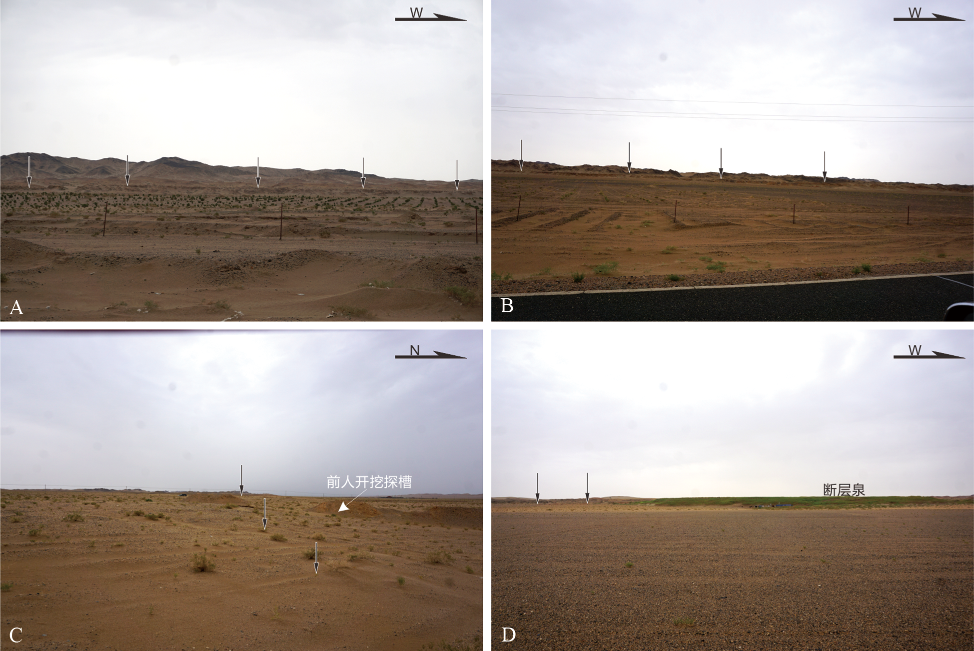
图15 航天城断层 A,B—断层中段断层陡坎;C—断层东端陡坎和前人开挖探槽;D—断层西段出露断层泉与断层陡坎。
Fig.15 Landform in the Hangtiancheng fault zone

图16 北山-阿拉善地区活动断层分布图
Fig.16 Distribution of active faults in the Beishan-Alxa region

图17 同性质走滑断层控制下形成的拉分盆地(据文献[102]修改)
Fig.17 Pull-apart basins in the overstep region between two strike-slip faults with the same kinematics. Modified after [102].

图18 南蒙古—青藏高原北侧变形机制 (青藏地区上地幔/下地壳各向异性数据来自文献[115,123⇓⇓⇓⇓⇓⇓⇓⇓⇓-133];阿尔金断层两侧数据来自文献[115,134];天山地区数据来自文献[135⇓⇓-138];蒙古地区数据来自文献[109,139⇓⇓⇓-143])
Fig.18 A deformation model for the northern Tibetan Plateau-southern Mongolia region (Tibetan Plateau anisotropy data of upper mantle/lower crust from [115,123⇓⇓⇓⇓⇓⇓⇓⇓⇓-133]; Altyn Tagh Fault data from [115,134]; Tianshan data from [135⇓⇓-138]; Mongolia data from [109,139⇓⇓⇓-143])
| [20] |
WALKER R T, NISSEN E, MOLOR E, et al. A re-interpretation of the active faulting in central Mongolia[J]. Geology, 2007, 35: 759-762.
DOI URL |
| [21] |
WALKER T R, WEGMANN K W, BAYASGALAN A, et al. The Egiin Davaa prehistoric rupture, central Mongolia: a large magnitude normal faulting earthquake on a reactivated fault with little cumulative slip located in a slowly deforming intraplate setting[J]. Geological Society, London, Special Publications, 2017, 432: 187-212.
DOI URL |
| [22] | RUDERSDORF A. Neotectonic structures and Late Quaternary tectonics in the slowly deforming ejina Basin[D]. Aachen: RWTH Aachen University, 2016. |
| [23] |
YUE Y J, LIOU J. Two-stage evolution model for the Altyn Tagh fault, China[J]. Geology, 1999, 27: 227-230.
DOI URL |
| [24] | KURTZ R, KLINGER Y, FERRY M. Horizontal surface-slip distribution through several seismic cycles: the Eastern Bogd fault, Gobi-Altai, Mongolia[J]. Tectonophysics, 2018, 734: 167-182. |
| [25] | LIU M, YANG Y, SHEN Z, et al. Active tectonics and intracontinental earthquakes in China: the kinematics and geodynamics[C]//STEIN S, MAZZOTTI S. Continental intraplate earthquakes:science, hazard, and policy issues. Boulder: Geological Society of America, 2007, 425: 209-318. |
| [26] | 俞晶星, 郑文俊, 雷启云, 等. 阿拉善地块南部雅布赖山前断裂的运动学特征及意义初探[J]. 地震地质, 2013, 35(4): 731-744. |
| [27] | ZHANG J, CUNNINGHAMD, YUN L, et al. Kinematic variability of late Cenozoic fault systems and contrasting mountain building processes in the Alxa block, western China[J]. Journal of Asian Earth Sciences, 2021, 205, 104597. |
| [28] | RUDERSDORF A, HARTMANN K, YU K, et al. Seismites as indicators for Holocene seismicity in the northeastern Ejina Basin, Inner Mongolia[C]//LANDGRAF A, KUBLER S, HINTERSBERGER E, et al. Seismicity, fault rupture and earthquake hazards in slowly deforming regions. London: Geological Society of London, 2017, 432: 213-231. |
| [29] |
WANG J, CHEN L, SU R, et al. The Beishan underground research laboratory for geological disposal of high-level radioactive waste in China: planning, site selection, site characterization and in situ tests[J]. Journal of Rock Mechanics and Geotechnical Engineering, 2018, 10(3): 411-435.
DOI URL |
| [30] | 郭召杰, 张志诚, 张臣, 等. 青藏高原北缘阿尔金走滑边界的侧向扩展: 甘肃北山晚新生代走滑构造与地壳稳定性分析[J]. 地质通报, 2008, 27(10): 1678-1686. |
| [31] |
ZHANG J, LI J, LI Y, et al. How did the Alxa Block respond to the Indo-Eurasian collision?[J] International Journal of Earth Sciences, 2009, 98(6): 1511-1528.
DOI URL |
| [32] |
YU J X, ZHENG W J, KIRBY E, et al. Kinematics of late Quaternary slip along the Yabrai fault: implications for Cenozoic tectonics across the Gobi Alashan block, China[J]. Lithosphere, 2016, 8: 199-218.
DOI URL |
| [33] | YU J X, ZHENG W J, ZHANG P Z, et al. Late Quaternary strike-slip along the Taohuala Shan-Ayouqi fault zone and its tectonic implications in the Hexi Corridor and the southern Gobi Alashan, China[J]. Tectonophysics, 2017, 21: 28-44. |
| [34] | 李令喜, 张洪安, 李继东, 等. 银额盆地及周缘的两期晚新生代伸展构造: 喜马拉雅碰撞造山远程效应的两个构造间歇期[J]. 地质科学, 2019, 54(2): 386-397. |
| [35] |
XIAO Q, SHAO G, LIU J, et al. Eastern termination of the Altyn Tagh Fault, western China: constraints from a magnetotelluric survey[J]. Journal of Geophysical Research: Solid Earth, 2015, 120(5): 2838-2858.
DOI URL |
| [36] |
YANG H, YANG X, ZHAN Y, et al. Quaternary activity of the Beihewan Fault in the southeastern Beishan Wrench Belt, western China: implications for crustal stability and intraplate earthquake hazards north of Tibet[J]. Journal of Geophysical Research: Solid Earth, 2019, 124: 13286-13309.
DOI URL |
| [37] | YANG H, YANG X, CUNNINGHAM D, et al. A regionally evolving transpressional duplex along the northern margin of the Altyn Tagh fault: new kinematic and timing constraints from the Sanweishan and Nanjieshan, China[J]. Tectonics, 2020, 39: e2019TC005749. |
| [38] | YANG H, YANG X, CUNNINGHAM D, et al. Late Miocene to Quaternary development of the Jiujing Basin, southern Beishan Block, China: implications for the kinematics and timing of crustal reactivation North of Tibet[J]. Lithosphere, 2021(1): 6670365. |
| [39] |
YANG H, CUNNINGHAM D, YANG X. Quaternary crustal reactivation of the southwestern Beishan, NW China: the Liuyuan sinistral transpressional duplex[J]. Tectonophysics, 2021, 803: 228758.
DOI URL |
| [1] |
MOLNAR P, TAPPONNIER P. Cenozoic tectonics of Asia: effects of a continental collision[J]. Science, 1975, 189: 419-426.
DOI URL |
| [2] |
MOLNAR P, ENGLAND P, MARTINOD J. Mantle dynamics, uplift of the Tibetan Plateau, and the Indian monsoon[J]. Review of Geophysics, 1993, 31: 357-396.
DOI URL |
| [3] |
TAPPONNIER P, XU Z Q, FRANCOISE R. Oblique stepwise rise and growth of the Tibet Plateau[J]. Science, 2001, 294(5547): 1671-1677.
PMID |
| [4] |
TAPPONNIER P, MOLNAR P. Active faulting and Cenozoic tectonics of the Tien Shan, Mongolia, and Baykal regions[J]. Journal of Geophysical Research, 1979, 84: 3425-3459.
DOI URL |
| [5] |
TAPPONNIER P, PELTZER P, LE DAIN A Y, et al. Propagating extronics in Asia: new insights from experiments with plasticine[J]. Geology, 1982, 10(12): 611-616.
DOI URL |
| [6] |
ENGLAND P C, HOUSEMAN G A. Finite strain calculations of continental deformation. 2. Comparison with India-Asia collision[J]. Journal of Geophysical Research, 1986, 91: 3664-3676.
DOI URL |
| [7] |
ZHANG P Z, BURCHFIEL B C, MOLNAR P, et al. Amount and style of Late Cenozoic deformation in the Liupan Shan area, Ningxia Autonomous Region, China[J]. Tectonics, 1991, 10(6): 1111-1129.
DOI URL |
| [8] |
YIN A, RUMELHART P E, BUTLER R, et al. Tectonic history of the Altyn Tagh fault system in northern Tibet inferred from Cenozoic sedimentation[J]. Geological Society of America Bulletin, 2002, 114(10): 1257-1295.
DOI URL |
| [9] |
YIN A, DANG Y Q, ZHANG M, et al. Cenozoic tectonic evolution of the Qaidam basin and its surrounding regions (Part 3): structural geology, sedimentation, and regional tectonic reconstruction[J]. Geological Society of America Bulletin, 2008, 120(7/8): 847-876.
DOI URL |
| [10] |
WEBB L E, JOHNSON C L. Tertiary strike-slip faulting in southeastern Mongolia and implications for Asian tectonics[J]. Earth and Planetary Science Letters, 2006, 241: 323-335.
DOI URL |
| [40] | YANG H, LI A, CUNNINGHAM D, et al. An evolving lithospheric-scale wrench fault system along the eastern end of the Altyn Tagh fault: kinematics and Quaternary activity of the Heishan fault system, western China[J]. Tectonics, 2023, 42: e2023TC007764. |
| [41] |
YUN L, ZHANG J, WANG J, et al. Active deformation to the north of the Altyn Tagh Fault: constraints on the northward growth of the northern Tibetan Plateau[J]. Journal of Asian Earth Sciences, 2020, 198: 104312.
DOI URL |
| [42] | 云龙, 张进, 徐伟, 等. 北山南缘活动构造的基本特征及其意义[J]. 地质论评, 2019, 65: 825-838. |
| [43] | 云龙, 张进, 徐伟, 等. 河西走廊西段花海断裂几何学、运动学及区域构造意义[J]. 地球科学, 2021, 46(1): 259-271. |
| [44] | 云龙, 张进, 王驹, 等. 甘肃北山南部活动断裂的发现及其区域构造意义[J]. 地质力学学报, 2021, 27(2): 195-207. |
| [45] | 张波, 何文贵, 刘炳旭, 等. 甘肃北山南缘俄博庙断裂的新活动特征及活动速率[J]. 地震地质, 2020, 42 (2): 455-471. |
| [46] | 张波, 郑龙, 何文贵, 等. 阿拉善地块西部鼎新断裂的发现及其构造意义[J]. 地震研究, 2022, 45(4): 543-551. |
| [47] |
XIAO W J, WINDLEY B F, SUN S, et al. A tale of amalgamation of three Permo-Triassic collage systems in Central Asia: oroclines, sutures, and terminal accretion[J]. Annual Review of Earth and Planetary Sciences, 2015, 43(150): 477-507.
DOI URL |
| [48] |
BADARCH G, CUNNINGHAM W D, WINDLEY B F. A new terrane subdivision for Mongolia: implications for the Phanerozoic crustal growth of Central Asia[J]. Journal of Asian Earth Sciences, 2002, 21: 87-110.
DOI URL |
| [49] | 左国朝, 张淑玲, 何国琦, 等. 北山地区早古生代板块构造特征[J]. 地质科学, 1990, 25(4): 305-314. |
| [50] |
ZUO G C, ZHANG S L, HE G Q, et al. Plate tectonic characteristics during the early paleozoic in Beishan near the Sino-Mongolian border region, China[J]. Tectonophysics, 1991, 188: 385-392.
DOI URL |
| [51] |
ZHENG R G, WU T R, ZHANG W, et al. Late Paleozoic subduction system in the northern margin of the Alxa block, Altaids: geochronological and geochemical evidences from ophiolites[J]. Gondwana Research, 2014, 25(2): 842-858.
DOI URL |
| [52] | 辛后田, 牛文超, 田健, 等. 内蒙古北山造山带时空结构与古亚洲洋演化[J]. 地质通报, 2020, 39(9): 1297-1316. |
| [53] | SONG D F, XIAO W J, WINDLEY B F, et al. Closure of the Paleo-Asian Ocean in the Middle-Late Triassic (Ladinian-Carnian): evidence from provenance analysis of retroarc sediments[J]. Geophysical Research Letters, 2021, 48(14): p.e2021GL094276. |
| [54] | CUNNINGHAM D. Folded basinal compartments of the southern Mongolian borderland: a structural archive of the final consolidation of the Central Asian Orogenic Belt[J]. Geosciences, 2017, 7(2). DOI: 10.3390/geosciences7010002. |
| [55] |
ZHANG J, YUN L, ZHANG B, et al. Deformation at the easternmost Altyn Tagh fault: constraints on the growth of the northern Qinghai-Tibetan Plateau[J]. Acta Geologica Sinica (English Edition), 2020, 94(4): 988-1006.
DOI URL |
| [56] | ZHANG B, ZHANG J, ZHAO H, et al. Kinematics and geochronology of Late Paleozoic-Early Mesozoic ductile deformation in the Alxa Block, NW China: new constraints on the evolution of the central Asian Orogenic Belt[J]. Lithoshpere, 2021(1): 3365581. |
| [57] |
ZHANG J, CUNNINGHAMD, QU J F, et al. Poly-phase accretionary, collisional and intraplate tectonism in the Langshan region of the Alxa Block, China: unravelling the complex structural evolution of the southern central Asian Orogenic Belt[J]. Gondwana Research, 2022, 105: 25-50.
DOI URL |
| [58] |
ZHANG J, QU J F, ZHANG B H, et al. Determination of an intracontinental transform system along the southern Central Asian Orogenic Belt in the latest Paleozoic[J]. American Journal of Science, 2022, 322(7): 851-897.
DOI URL |
| [59] |
ZHAO H, ZHANG J, QU J F, et al. Geometry, kinematics and chronology of the Yabrai shear zone in the Alxa Block: constraints on the late Paleozoic dextral shear system in the southern margin of the Central Asian orogenic belt[J]. Journal of Structural Geology, 2022, 158: 104575.
DOI URL |
| [60] |
HUI J, CHENG H Y, ZHANG J, et al. Early Cretaceous continent basalts in the Alxa Block, NW China: geochronology, geochemistry, and tectonic implications[J]. International Geology Review, 2021, 63(7): 882-899.
DOI URL |
| [61] |
ZHANG J, WANG Y N, QU J F, et al. Mesozoic intracontinental deformation of the Alxa Block in the middle part of Central Asian Orogenic Belt: a review[J]. International Geological Review, 2021, 63: 1490-1520.
DOI URL |
| [62] | CUNNINGHAM W D, ZHANG J. China | Mongolia: Mesozoic-Cenozoic[M]// ALDERTOND, ELIASS A. Encyclopedia of geology. 2nd ed. Amsterdam: Elsevier, 2021: 509-525. |
| [63] | YUE Y J, LIOU J, GRAHAM S. Tectonic correlation of Beishan and Inner Mongolia orogens and its implications for the palinspastic reconstruction of north China[J]. Geological Society of America Memoir, 2001, 194: 101-116. |
| [64] |
YUE Y J, RITTS B, GRAHAM S. Initiation and long-term slip history of the Altyn Tagh fault[J]. International Geology Review, 2001, 43: 1087-1093.
DOI URL |
| [65] | 陈文彬, 徐锡伟. 阿拉善地块南缘的左旋走滑断裂与阿尔金断层带的东延[J]. 地震地质, 2006, 28(2): 319-324 |
| [66] |
DARBY B J, RITTS B D, YUE Y J. Did the Altyn Tagh fault extend beyond the Tibetan Plateau?[J] Earth and Planetary Science Letters, 2005, 240: 425-435.
DOI URL |
| [67] |
ZHENG Y, ZHANG Q, WANG Y. Great Jurassic thrust sheets in Beishan (North Mountains) Gobi areas of China and southern Mongolia[J]. Journal of Structural Geology, 1996, 18: 1111-1126.
DOI URL |
| [68] | ZHANG J, CUNNINGHAM D. Kilometer-scale refolded folds caused by strike-slip reversal and intraplate shortening in the Beishan region, China[J]. Tectonics, 2012, 31: 3009. |
| [69] |
GIPPESPIE J, GLORIE S, XIAO W J, et al. Mesozoic reactivation of the Beishan, southern Central Asian Orogenic Belt: insights from low-temperature thermochronology[J]. Gondwana Research, 2017, 43: 107-122.
DOI URL |
| [70] | 王峰, 苏刚, 晋佩东. 甘肃北山地区晚第四纪构造变形特征及演化趋势[J]. 地震研究, 2004, 27 (2): 173-178. |
| [71] | 王峰, 王驹, 范洪海, 等. 甘肃北山旧井地区晚第四纪活动断裂分布及其构造意义[J]. 地质论评, 2005, 51(3): 250-256. |
| [72] | 云龙, 张进, 王驹, 等. 三危山活动断裂水平运动特征与机制: 对青藏高原北缘生长的限定[J]. 地震地质, 2019, 41: 1333-1349. |
| [73] | 云龙, 张进, 肖骑斌, 等. 青藏高原北缘三危山断裂晚第四纪以来的逆冲运动及其深部构造特征[J]. 地质学报, 2019, 93: 2107-2122. |
| [74] | 左玉琦, 杨海波, 杨晓平, 等. 阿拉善地块南缘北大山断裂的晚第四纪构造活动证据[J]. 地震地质, 2023, 45(2): 355-376. |
| [75] |
ZHANG J, LI J Y, LI Y F, et al. Mesozoic-Cenozoic multi-stage intraplate deformation events in the Langshan region and their tectonic implications[J]. Acta Geologica Sinica (English Edition), 2014, 88: 78-102.
DOI URL |
| [76] | 张北航, 张进, 曲军峰, 等. 阿拉善东北缘晚中生代以来陆内变形、古应力特征及构造背景[J]. 地质通报, 2021, 40(1): 110-124. |
| [77] | RAO G, CHEN P, HU J M, et al. Timing of Holocene paleo-earthquakes along the Langshan Piedmont Fault in the western Hetao Graben, North China: implications for seismic risk[J]. Tectonophysics, 2016, 677: 115-124. |
| [78] |
LEI Q Y, YU J X, ZHANG P Z, et al. Tectonic geomorphology and prehistoric earthquakes of the West Helanshan fault, West Ordos, and its implications for regional tectonics and seismic hazard[J]. Tectonophysics, 2022, 833: 229375.
DOI URL |
| [79] | BECKEN M, HÖLZ S, FIEDLER-VOLMER R, et al. Electrical resistivity image of the Jingsutu Graben at the NE margin of the Ejina Basin (NW China) and implications for the basin development[J]. Geophysical Research Letters, 2007, 34: L09315. |
| [80] |
MENG Q R. What drove late Mesozoic extension of the northern China-Mongolia tract?[J] Tectonophysics, 2003, 369(3/4): 155-174.
DOI URL |
| [81] | WANG T, ZENG Y D, ZHANG J J, et al. Pattern and kinematic polarity of late Mesozoic extension in continental NE Asia: perspectives from metamorphic core complexes[J]. Tectonics, 2011, 30: TC6007. |
| [82] |
LIN W, WEI W. Late Mesozoic extensional tectonics in the North China Craton and its adjacent regions: a review and synthesis[J]. International Geology Review, 2020, 62(7/8): 811-839.
DOI URL |
| [83] | GAO R, CHENG X Z, WU G J. Lithospheric structure and geodynamic model of the Golmud-Ejin transect in northern Tibet[C]// MACFARLANE A, SORKHABI R B, QUADE J. Himalaya and Tibet:mountain roots to mountain tops. Boulder: Geological Society of America, Special Paper, 1999, 328: 9-17. |
| [84] | COWGILL E, YIN A, HARRISON T M, et al. Reconstruction of the Altyn Tagh fault based on U-Pb geochronology: role of back thrusts, mantle sutures, and heterogeneous crustal strength in forming the Tibetan Plateau[J]. Journal of Geophysical Research, 2003, 108: 2346. |
| [85] | XU X W, TAPPONNIER P, VAV DER WOERD J, et al. Late Quaternary sinistral slip rate along the Altyn Tagh fault and its structural transformation model[J]. Science in China Series D: Earth Science, 2005, 48: 384-397. |
| [86] | ZHANG P Z, MOLNAR P, XU X. Late Quaternary and present-day rates of slip along the Altyn Tagh Fault northern margin of the Tibetan Plateau[J]. Tectonics, 2007, 26: 5010. |
| [87] | MOLNAR P, STOCK J M. Slowing of India’s convergence with Eurasia since 20 Ma and its implications for Tibetan mantle dynamics[J]. Tectonics, 2009, 28: 3001. |
| [88] | XIAO Q B, YU G, ZENG-LIU J, et al. Structure and geometry of the Aksay restraining double bend along the Altyn Tagh fault, northern Tibet, imaged using magnetotelluric method[J]. Geophysical Research Letters, 2017, 255: 4090-4097. |
| [89] |
RITTS B D, YUE Y J, GRAHAM S A, et al. From sea level to high elevation in 15 million years: uplift history of the northern Tibetan Plateau margin in the Altun Shan[J]. American Journal of Science, 2008, 308(5): 657-678.
DOI URL |
| [90] | ŞENGÖR A C, ZABCI C, NATAL’IN B A. Continental transform faults: congruence and incongruence with normal plate kinematics[M]//DUARTE J C. Transform plate boundaries and fracture zones. Amsterdam: Elsevier, 2019: 169-247. |
| [91] | 徐锡伟, TAPPONNIER P, VAN DER WOERD J, 等. 阿尔金断裂带晚第四纪左旋走滑速率及其构造运动转换模式讨论[J]. 中国科学(D辑), 2003, 33: 965-974. |
| [92] | 张宁, 郑文俊, 刘兴旺, 等. 河西走廊西端黑山断裂运动学特征及其在构造转换中的意义[J]. 地球科学与环境学报, 2016, 38(2): 245-257. |
| [93] |
BURCHFIEL B C, DENG Q D, MOLNAR P, et al. Intracrustal detachment with zones of continental deformation[J]. Geology, 1989, 17: 748-752.
DOI URL |
| [94] |
MEYER B, TAPPONNIER P, BOURJOT L, et al. Crustal thickening in Gansu-Qinghai, lithospheric mantle subduction, and oblique, strike-slip controlled growth of the Tibet plateau[J]. Geophysical Journal International, 1998, 135: 1-47.
DOI URL |
| [95] |
MÉTIVIER F, GAUDEMER Y, TAPPONNIER P, et al. Northeastward growth of the Tibet plateau deduced from balanced reconstruction of two depositional areas: the Qaidam and Hexi Corridor basins, China[J]. Tectonics, 1998, 17(6): 823-842.
DOI URL |
| [96] | 国家地震局阿尔金活动断裂课题组. 阿尔金活动断裂带[M]. 北京: 地震出版社, 1992. |
| [97] | 朱利东, 王成善, 郑荣才, 等. 青藏高原东北缘酒泉盆地的演化特征与宽台山—黑山断裂的性质[J]. 地质通报, 2005, 24(9): 837-840. |
| [98] | 张进, 李锦轶, 李彦峰, 等. 阿拉善地块新生代构造作用: 兼论阿尔金断裂新生代东向延伸问题[J]. 地质学报, 2007, 81(11): 1481-1497. |
| [99] | 何文贵, 袁道阳, 王爱国, 等. 酒泉盆地北侧金塔南山北缘断裂西段全新世活动特征[J]. 地震, 2012, 32: 59-66. |
| [100] | 张波, 何文贵, 庞炜, 等. 青藏块体北部金塔南山断裂晚第四纪走滑活动的地质地貌特征[J]. 地震地质, 2016, 38(1): 1-21. |
| [101] |
CUNNINGHAM D. Tectonic setting and structural evolution of the Late Cenozoic Gobi Altai orogen[J]. Geological Society, London, Special Publications, 2010, 338: 361-387.
DOI URL |
| [11] |
ZHENG W J, ZHANG P Z, GE W P, et al. Late Quaternary slip rate of the South Heli Shan Fault (northern Hexi Corridor, NW China) and its implications for northeastward growth of the Tibetan Plateau[J]. Tectonics, 2013, 32(2): 271-293.
DOI URL |
| [12] |
CUNNINGHAM W D, WINDLEY B F, DORJNAMJAA D, et al. A structural transect across the Mongolian western Altai active transpressional mountain building in central Asia[J]. Tectonics, 1996, 15: 142-156.
DOI URL |
| [13] |
CUNNINGHAM D. Cenozoic normal faulting and regional doming in the southern Hangay region, Central Mongolia: implications for the origin of the Baikal rift province[J]. Tectonophysics, 2001, 331: 389-411.
DOI URL |
| [14] |
CUNNINGHAM D, OWEN L A, SNEE L W, et al. Structural framework of a major intracontinental orogenic termination zone: the easternmost Tien Shan, China[J]. Journal of the Geological Society, London, 2003, 160: 575-590.
DOI URL |
| [15] |
CUNNINGHAM D. Active intracontinental transpressional mountain building in the Mongolian Altai: defining a new class of orogen[J]. Earth and Planetary Science Letters, 2005, 240: 436-444.
DOI URL |
| [16] |
CUNNINGHAM D. Mountain building processes in intracontinental oblique deformation belts: lessons from the Gobi Corridor, central Asia[J]. Journal of Structural Geology, 2013, 46: 255-282.
DOI URL |
| [17] |
CUNNINGHAM D, ZHANG J, LI YF. Late Cenozoic structural evolution of the Sanweishan and Nanjieshan, western China: sinistral transpressional reactivation of Archean basement directly north of the Altyn Tagh Fault along Tibet’s evolving northern boundary[J]. Tectonophysics, 2016, 687: 111-128.
DOI URL |
| [18] | BALJINNYAM I, BAYASGALAN A, BORISOV B A, et al. Ruptures of major earthquakes and active deformation in Mongolia and its surroundings[J]. Geological Society of America Memoirs, 1993, 181: 1-62. |
| [19] | 胥广银, 汪素云, 环文林, 等. 中蒙弧地区地震活动性及其地球动力学成因研究[J]. 地球物理学报, 2014, 57(7): 2372-2385. |
| [102] | DOOLEY T, MCCLAY K. Analog Modeling of Pull-Apart Basins[J]. AAPG Bulletin, 1997, 81(11): 1804-1826. |
| [103] |
DECELLES P G, GILES K A. Foreland basin systems[J]. Basin Research, 1996, 8: 105-123.
DOI URL |
| [104] |
XIAO W J, MAO Q G, WINDLEY B F, et al. Paleozoic multiple accretionary and collisional processes of the Beishan orogenic collage[J]. American Journal of Science, 2010, 310(10): 1553-1594.
DOI URL |
| [105] |
ZHANG J, ZHANG Y P, XIAO W X, et al. Linking the Alxa Terrane to the eastern Gondwana during the Early Paleozoic: constraints from detrital zircon U-Pb ages and Cambrian sedimentary records[J]. Gondwana Research, 2015, 28: 1168-1182.
DOI URL |
| [106] | COMEAU M J, STEIN C, BECHEN M, et al. Geodynamic modeling of lithospheric removal and surface deformation: application to intraplate uplift in central Mongolia[J]. Journal of Geophysical Research: Solid Earth, 2021, 126: e2020JB021304. |
| [107] | WU Y, BAO X W. Cenozoic uplift and volcanism of Hangai Dome, central Mongolia Triggered by lower mantle upwellings[J]. Geophysical Research Letters, 2023, 50: e2023GL102838. |
| [108] |
WINDLEY B, ALLEN M. Mongolian plateau: evidence for a late Cenozoic mantle plume under central Asia[J]. Geology, 1993, 21: 295-298.
DOI URL |
| [109] |
BARRUOL G, DESCHAMPS A, DÉVERCHÈÈRE J, et al. Upper mantle flow beneath and around the Hangay dome, central Mongolia[J]. Earth and Planetary Science Letters, 2008, 274: 221-233.
DOI URL |
| [110] |
WESTAWAY R. Crustal volume balance during the India-Eurasia collision and altitude of the Tibetan Plateau: a working hypothesis[J]. Journal of Geophysical Research, 1995, 100(B8): 15173-15192.
DOI URL |
| [111] |
LABORDE A, BARRIER L, SIMOES M, et al. Cenozoic deformation of the Tarim Basin and surrounding ranges (Xinjiang, China): a regional overview[J]. Earth-Science Reviews, 2019, 197: 102891.
DOI URL |
| [112] |
CLARK M K, ROYDEN L H. Topographic ooze: building the eastern margin of Tibet by lower crustal flow[J]. Geology, 2000, 28: 703-706.
DOI URL |
| [113] |
HUANG Z C, WANG P, ZHAO D, et al. Three-dimensional P wave azimuthal anisotropy in the lithosphere beneath China[J]. Journal of Geophysical Research: Solid Earth, 2014, 119: 5686-5712.
DOI URL |
| [114] |
HUANG Z C, WANG L S, ZHAO D P, et al. Seismic anisotropy and mantle dynamics beneath China[J]. Earth and Planetary Science Letters, 2011, 306: 105-117.
DOI URL |
| [115] | 冯永革, 于勇, 陈永顺, 等. 阿尔金断裂西部邻区的上地幔各向异性研究[J]. 地球物理学报, 2016, 59(5): 1629-1636. |
| [116] |
LIU L, GAO S S, LIU K H, et al. A database of teleseismic shear-wave splitting measurements for the Ordos Block and adjacent areas[J]. Seismological Research Letters, 2022, 93: 2731-2739.
DOI URL |
| [117] |
LI Z, KREEMER C. Eastward mantle flow field underneath East Asia quantified by combining shear-wave splitting orientations and absolute plate motion observations[J]. Earth and Planetary Science Letters, 2021, 566: 116969.
DOI URL |
| [118] |
WORRALL D M, KRUGLYAK V, KUNST F. Tertiary tectonics of the Sea of Okhotsk, Russia: farfield effects of the India-Eurasia collision[J]. Tectonics, 1996, 15(4): 813-826.
DOI URL |
| [119] | CALAIS E, VERGNOLLE M, SAN’KOV V, et al. GPS measurements of crustal deformation in the Baikal-Mongolia area (1994-2002): implications for current kinematics of Asia[J]. Journal of Geophysical Research, 2003, 108(B10): 2501. |
| [120] |
JOLIVET L, FACCENNA C, BECKER T, et al. Mantle flow and deforming continents: from India-Asia convergence to Pacific subduction[J]. Tectonics, 2018, 37(9): 2887-2914.
DOI PMID |
| [121] | WANG M, SHEN Z K. Present-day crustal deformation of continental China derived from GPS and its tectonic implications[J]. Journal of Geophysical Research: Solid Earth, 2020, 125: e2019JB018774. |
| [122] |
YIN A. Cenozoic tectonic evolution of Asia: a preliminary synthesis[J]. Tectonophysics, 2010, 488: 293-325.
DOI URL |
| [123] |
MCNAMARA D E, OWENS T J, SILVER PG, et al. Shear wave anisotropy beneath the Tibetan Plateau[J]. Journal of Geophysical Research, 1994, 99: 13655-13665.
DOI URL |
| [124] |
GUILBERT J, POUPINET G, JIANG M. A study of azimuthal P residuals and shear wave splitting across the Kunlun range (Northern Tibetan plateau)[J]. Physics of the Earth and Planetary Interiors, 1996, 95(3/4): 167-174.
DOI URL |
| [125] |
HUANG W C, NI J F, TILMANN F, et al. Seismic polarization anisotropy beneath the central Tibetan Plateau[J]. Journal of Geophysical Research, 2000, 105(B12): 27979-27989.
DOI URL |
| [126] | LIU K H, GAO S S, GAO Y, et al. Shear wave splitting and mantle flow associated with the deflected Pacific slab beneath northeast Asia[J]. Journal of Geophysical Research, 2008, 113: B01305. |
| [127] |
ZHAO J M, YUAN X H, LIU H B, et al. The boundary between the Indian and Asian tectonic plates below Tibet[J]. Proceedings of the National Academy of Sciences of the United States of America, 2010, 107: 11229-11233.
DOI PMID |
| [128] |
CHEN W P, MARTIN M, TSENG T, et al. Shear-wave birefringence and current configuration of converging lithosphere under Tibet[J]. Earth Planet Science Letters, 2010, 295(1/2): 297-304.
DOI URL |
| [129] |
KIND R, YUAN X H. Seismic images of the biggest crash on Earth[J]. Science, 2010, 329(5998): 1479-1480.
DOI URL |
| [130] |
LI Y, WU Q, ZHANG F, et al. Seismic anisotropy of the Northeastern Tibetan Plateau from shear wave splitting analysis[J]. Earth and Planetary Science Letters, 2011, 304: 147-157.
DOI URL |
| [131] |
LEVIN V, ROECKER S, GRAHAM P, et al. Seismic anisotropy indicators in western Tibet: shear wave splitting and receiver function analysis[J]. Tectonophysics, 2008, 462(1/2/3/4): 99-108.
DOI URL |
| [132] |
LEVIN V, HUANG G D, ROECKER S. Crust-mantal coupling at the northern edge of the Tibetan Plateau: evidence from focal mechanisms and observations of seismic anisotropy[J]. Tectonophysics, 2013, 584: 221-229.
DOI URL |
| [133] |
WU J, ZHANG Z J, KONG F S, et al. Complex seismic anisotropy beneath western Tibet and its geodynamic implications[J]. Earth and Planetary Science Letters, 2015, 413: 167-175.
DOI URL |
| [134] |
HERQUEL G, TAPPONNIER P, WITTLINGER G, et al. Teleseismic shear wave splitting and lithospheric anisotropy beneath and across the Altyn Tagh fault[J]. Geophysical Research Letters, 1999, 26(21): 3225-3228.
DOI URL |
| [135] | LI A, CHEN C. Shear wave splitting beneath the central Tien Shan and tectonic implications[J]. Geophysical Research Letters, 2006, 33: L22303. |
| [136] | CHEN YP, WANG L S, MI N, et al. Shear wave splitting observations in the Chinese Tianshan orogenic belt[J]. Geophysical Research Letters, 2005, 32: L07306. |
| [137] | 鲍子文, 髙原. 天山构造带及邻区地壳各向异性[J]. 地球物理学报, 2017, 60(4): 1359-1375. |
| [138] | 鲍子文, 高原. 天山构造带地震各向异性及动力学机制研究进展[J]. 中国地震, 2019, 35(4): 589-601. |
| [139] | SILVER P G, CHAN W W. Shear wave splitting and subcontinental mantle deformation[J]. Jounral of Geophysical Research, 1991, 96: 16429-16454. |
| [140] |
VINNIK L P, MAKEYEVA L I, MILEV A, et al. Global patterns of azimuthal anisotropy and deformations in the continental mantle[J]. Geophysical Journal International, 1992, 111(3): 433-437.
DOI URL |
| [141] |
GAO S, DAVIS P M, LIU H, et al. Seismic anisotropy and mantle flow beneath the Baikal rift zone[J]. Nature, 1994, 371: 149-151.
DOI |
| [142] |
GAO S, DAVIS P M, LIU H, et al. SKS splitting beneath continental rift zones[J]. Journal of Geophysical Research, 1997, 102: 22781-22797.
DOI URL |
| [143] |
DRICKER I, ROECKER S, VINNIK L, et al. Upper-mantle anisotropy beneath the Altai-Sayan region of central Asia[J]. Physics of the Earth and Planetary Interiors, 2002, 131: 205-223.
DOI URL |
| [1] | 刘玲霞, 路睿, 谢文苹, 刘博, 王亚茹, 姚海慧, 蔺文静. 青藏高原东北部温泉分布及水文地球化学特征[J]. 地学前缘, 2024, 31(6): 173-195. |
| [2] | 刘德民, 王杰, 姜淮, 赵悦, 郭铁鹰, 杨巍然. 青藏高原形成演化动力机制及其远程效应[J]. 地学前缘, 2024, 31(1): 154-169. |
| [3] | 程永志, 高锐, 卢占武, 李文辉, 王光文, 陈司, 吴国炜, 蔡玉国. 青藏高原东北缘祁连造山带东段深部结构及其动力学过程[J]. 地学前缘, 2023, 30(5): 314-333. |
| [4] | 夏敦胜, 杨军怀, 王树源, 刘鑫, 陈梓炫, 赵来, 牛潇毅, 金明, 高福元, 凌智永, 王飞, 李再军, 王鑫, 贾佳, 杨胜利. 雅鲁藏布江流域风成沉积空间格局、沉积模式及其环境效应[J]. 地学前缘, 2023, 30(4): 229-244. |
| [5] | 仝霄飞, 徐啸, 郭晓玉, 李春森, 向波, 余嘉豪, 罗旭聪, 袁梓昭, 林燕琪, 时宏城. 接收函数成像揭示东昆仑断裂带及其周缘地壳结构[J]. 地学前缘, 2023, 30(4): 270-282. |
| [6] | 刘晓宇, 杨文采, 陈召曦, 瞿辰, 于常青. 青藏高原东部地块的属性与演化[J]. 地学前缘, 2023, 30(3): 233-241. |
| [7] | 吴晨, 陈宣华, 丁林. 祁连造山带构造演化与新生代变形历史[J]. 地学前缘, 2023, 30(3): 262-281. |
| [8] | 贾承造, 陈竹新, 雷永良, 王丽宁, 任荣, 苏楠, 杨庚. 中国中西部褶皱冲断带构造变形机制与结构模型[J]. 地学前缘, 2022, 29(6): 156-174. |
| [9] | 孙辉, 刘晓东. 青藏高原隆升气候效应的数值模拟研究进展概述[J]. 地学前缘, 2022, 29(5): 300-309. |
| [10] | 栗兵帅, 颜茂都, 张伟林. 柴北缘早新生代旋转变形特征及其构造意义[J]. 地学前缘, 2022, 29(4): 249-264. |
| [11] | 龚承林, 刘力, 邵大力, 郭荣涛, 朱一杰, 齐昆. 晚中新世以来孟加拉-尼科巴扇跷跷板式沉积转换及其源-汇成因机制[J]. 地学前缘, 2022, 29(4): 25-41. |
| [12] | 高锐, 周卉, 卢占武, 郭晓玉, 李文辉, 王海燕, 李洪强, 熊小松, 黄兴富, 徐啸. 深地震反射剖面揭露青藏高原陆-陆碰撞与地壳生长的深部过程[J]. 地学前缘, 2022, 29(2): 14-27. |
| [13] | 卢占武, 高锐, Simon KLEMPERER, 王海燕, 董树文, 李文辉, 李洪强. 喜马拉雅西部雅鲁藏布江缝合带地壳尺度的构造叠置[J]. 地学前缘, 2022, 29(2): 210-217. |
| [14] | 张衡, 徐团伟, 裴顺平, 赵俊猛. 利用分布式光纤声传感设备开展青藏高原易贡湖浅层结构探测[J]. 地学前缘, 2021, 28(6): 227-234. |
| [15] | GAO Rui, ZHOU Hui, GUO Xiaoyu, LU Zhanwu, LI Wenhui, WANG Haiyan, LI Hongqiang, XIONG Xiaosong, HUANG Xingfu, XU Xiao. 深地震反射剖面揭露青藏高原陆-陆碰撞与地壳生长的深部过程[J]. 地学前缘, 2021, 28(5): 320-336. |
| 阅读次数 | ||||||
|
全文 |
|
|||||
|
摘要 |
|
|||||