地学前缘 ›› 2023, Vol. 30 ›› Issue (5): 314-333.DOI: 10.13745/j.esf.sf.2023.6.35
• “印度-欧亚大陆碰撞及其远程效应”专栏之九 • 上一篇 下一篇
程永志1( ), 高锐1,2,*(), 卢占武1, 李文辉1, 王光文1, 陈司1, 吴国炜1, 蔡玉国1
收稿日期:2023-06-06
修回日期:2023-06-20
出版日期:2023-09-25
发布日期:2023-10-20
通信作者:
*高 锐(1950—),男,教授,博士生导师,中国科学院院士,主要从事地球物理与深部探测研究。E-mail: gaorui66@mail.sysu.edu.cn
作者简介:程永志(1989—),男,博士,主要从事远震接收函数研究。E-mail: 1773996729@qq.com
基金资助:
CHENG Yongzhi1(), GAO Rui1,2,*(), LU Zhanwu1, LI Wenhui1, WANG Guangwen1, CHEN Si1, WU Guowei1, CAI Yuguo1
Received:2023-06-06
Revised:2023-06-20
Online:2023-09-25
Published:2023-10-20
摘要:
青藏高原东北缘祁连造山带东段由临夏地块和陇中地块组成,该地区经历了祁连洋闭合、华北地块和祁连地块的拼合、印度板块和欧亚板块碰撞等多期构造事件的影响,形成了现在复杂的构造格局。为了研究该地区不同地块的拼合位置和地质构造演化过程,我们利用覆盖研究区的33个中国地震科学台站探测Ⅱ期(ChinArrayⅡ, 2013—2016)宽频带流动台站3年的观测资料,利用远震P波接收函数H-κ叠加和共转换点叠加(CCP)方法获得了33个台站下方的地壳结构、泊松比、Moho面变化形态。研究结果显示:马衔山断裂是划分临夏地块和陇中地块的重要边界断裂,马衔山断裂作为一条穿壳断裂在我们的计算结果中表现为连续陡变的西倾负震相,该断裂是临夏地块和陇中地块的缝合线。临夏地块壳内分层结构明显,中下地壳存在低速异常,可能含有含盐流体,具有日本型岛弧特征。陇中地块的上地壳层状结构显著,中下地壳层状结构较弱且呈现较弱的低速特征,具有洋-岛玄武岩地壳特征,陇中地块原来可能由马里亚纳型岛弧构成。鄂尔多斯地块西南缘康拉德界面发育,Moho面横向变形较弱,具有稳定克拉通特征。六盘山构造带下方中上地壳表现为仰冲至鄂尔多斯地块西南缘之上的构造样式,我们认为这是六盘山构造带新生代隆升的深部构造证据。
中图分类号:
程永志, 高锐, 卢占武, 李文辉, 王光文, 陈司, 吴国炜, 蔡玉国. 青藏高原东北缘祁连造山带东段深部结构及其动力学过程[J]. 地学前缘, 2023, 30(5): 314-333.
CHENG Yongzhi, GAO Rui, LU Zhanwu, LI Wenhui, WANG Guangwen, CHEN Si, WU Guowei, CAI Yuguo. Deep structure and dynamics of the eastern segment of the Qilian orogenic belt in the northeastern margin of the Tibetan Plateau[J]. Earth Science Frontiers, 2023, 30(5): 314-333.

图1 青藏高原东北缘及其邻区构造概况(引自文献[13⇓⇓⇓⇓⇓⇓⇓-21]) A—喜马拉雅造山带和青藏高原及其周缘数字地形图;B—青藏高原东北缘周缘构造分布[13⇓-15],红色五角星表示台站分布位置,黑色实线AA'为CCP叠加剖面位置,绿色实线1~4表示大地电磁剖面位置[16⇓⇓-19],紫色线条5和6表示地震探测剖面位置[20-21]。
Fig.1 Tectonic setting of the northeastern margin of the Qinghai-Tibet Plateau and adjacent area. Adapted from [13⇓⇓⇓⇓⇓⇓⇓-21].

图2 439个远震事件分布图 图中色标表示震源深度,圆圈大小表示震级等级。
Fig.2 Distribution map of 439 teleseismic events

图3 台站62350和63056按反方位角等间距排列的接收函数 水平轴表示的是相对P波延迟时间。纵坐标轴表示的是按照反方位角等间距排列的接收函数条数(从下到上反方位角逐渐增加)其中PS、PPPS、PPSS+PSPS震相用红色实线标注。
Fig.3 Seismic receiver functions at stations 62350 and 63056, arranged anti-clockwise at equidistance intervals

图4 H-κ方法获得台站63056、63055、62354和62360下方地壳厚度和波速比结果 纵轴表示地壳厚度H,横轴表示波速比κ,绿色五角星对应的最佳拟合处,白色小方框内记录了台站号和对应的地壳厚度H、κ值。
Fig.4 Results of H-κ stacking at stations 63056, 63055, 62354, and 62360
| 地壳厚度/km | vP/(km·s-1) | vP/(km·s-1) |
|---|---|---|
| 0~20 | 5.80 | 3.36 |
| 20~50 | 6.50 | 3.75 |
| >50 | 8.04 | 4.47 |
表1 修正后的IASP91地壳速度结构模型
Table 1 Revised IASP91 crustal velocity structure model
| 地壳厚度/km | vP/(km·s-1) | vP/(km·s-1) |
|---|---|---|
| 0~20 | 5.80 | 3.36 |
| 20~50 | 6.50 | 3.75 |
| >50 | 8.04 | 4.47 |
| 序号 | 台站名 | 经度/(°) | 纬度/(°) | H/km | κ | σ | 构造单元 |
|---|---|---|---|---|---|---|---|
| 1 | 63058 | 101.8 | 35.2 | 57.61 | 1.69 | 0.23 | 西秦岭 |
| 2 | 63056 | 102.3 | 35.2 | 57.40 | 1.70 | 0.24 | |
| 3 | 62359 | 102.5 | 35.2 | 51.58 | 1.80 | 0.28 | |
| 4 | 63055 | 102.4 | 35.4 | 55.80 | 1.74 | 0.25 | |
| 5 | 62361 | 102.9 | 35.2 | 54.56 | 1.64 | 0.21 | |
| 6 | 62350 | 103.1 | 35.0 | 52.80 | 1.72 | 0.24 | 临夏地块 |
| 7 | 62371 | 103.3 | 35.5 | 51.60 | 1.81 | 0.28 | |
| 8 | 62349 | 103.6 | 35.0 | 53.00 | 1.74 | 0.25 | |
| 9 | 62362 | 103.7 | 35.3 | 51.01 | 1.84 | 0.29 | |
| 10 | 62355 | 103.9 | 35.2 | 49.60 | 1.79 | 0.27 | |
| 11 | 62364 | 104.2 | 35.4 | 50.80 | 1.73 | 0.25 | |
| 12 | 62357 | 104.3 | 35.2 | 51.00 | 1.73 | 0.25 | 陇中地块 |
| 13 | 62348 | 104.6 | 34.9 | 47.60 | 1.75 | 0.26 | |
| 14 | 62372 | 104.6 | 35.6 | 50.91 | 1.74 | 0.25 | |
| 15 | 62368 | 105.0 | 35.5 | 46.03 | 1.90 | 0.31 | |
| 16 | 62351 | 105.0 | 35.0 | 45.40 | 1.69 | 0.23 | |
| 17 | 62360 | 105.2 | 35.2 | 46.40 | 1.79 | 0.27 | |
| 18 | 62366 | 105.5 | 35.4 | 49.20 | 1.75 | 0.27 | |
| 19 | 62352 | 105.5 | 35.1 | 45.60 | 1.72 | 0.24 | |
| 20 | 62363 | 106.0 | 35.3 | 43.99 | 1.85 | 0.29 | 六盘山构造带 |
| 21 | 62354 | 106.2 | 35.1 | 45.40 | 1.78 | 0.27 | |
| 22 | 62358 | 106.6 | 35.2 | 47.60 | 1.84 | 0.29 | |
| 23 | 61058 | 106.6 | 35.0 | 46.60 | 1.77 | 0.27 | |
| 24 | 62373 | 106.6 | 35.6 | 44.00 | 1.76 | 0.26 | |
| 25 | 62356 | 107.0 | 35.2 | 49.04 | 1.65 | 0.21 | |
| 26 | 62367 | 107.1 | 35.4 | 48.34 | 1.76 | 0.26 | 鄂尔多斯地块 |
| 27 | 62353 | 107.4 | 35.1 | 43.54 | 1.66 | 0.22 | |
| 28 | 62369 | 107.5 | 35.5 | 45.50 | 1.78 | 0.27 | |
| 29 | 61057 | 107.8 | 34.9 | 44.60 | 1.77 | 0.27 | |
| 30 | 61060 | 107.8 | 35.2 | 46.00 | 1.66 | 0.25 | |
| 31 | 62365 | 107.8 | 35.4 | 46.80 | 1.72 | 0.24 | |
| 32 | 61059 | 108.1 | 35.1 | 43.51 | 1.78 | 0.27 | |
| 33 | 62370 | 108.4 | 35.5 | 43.60 | 1.78 | 0.27 |
表2 台站下方地壳厚度H、波速比κ及泊松比σ结果
Table 2 Crustal thickness (H), velocity ratio (κ) and Poisson’s ratio (σ) beneath seismic stations
| 序号 | 台站名 | 经度/(°) | 纬度/(°) | H/km | κ | σ | 构造单元 |
|---|---|---|---|---|---|---|---|
| 1 | 63058 | 101.8 | 35.2 | 57.61 | 1.69 | 0.23 | 西秦岭 |
| 2 | 63056 | 102.3 | 35.2 | 57.40 | 1.70 | 0.24 | |
| 3 | 62359 | 102.5 | 35.2 | 51.58 | 1.80 | 0.28 | |
| 4 | 63055 | 102.4 | 35.4 | 55.80 | 1.74 | 0.25 | |
| 5 | 62361 | 102.9 | 35.2 | 54.56 | 1.64 | 0.21 | |
| 6 | 62350 | 103.1 | 35.0 | 52.80 | 1.72 | 0.24 | 临夏地块 |
| 7 | 62371 | 103.3 | 35.5 | 51.60 | 1.81 | 0.28 | |
| 8 | 62349 | 103.6 | 35.0 | 53.00 | 1.74 | 0.25 | |
| 9 | 62362 | 103.7 | 35.3 | 51.01 | 1.84 | 0.29 | |
| 10 | 62355 | 103.9 | 35.2 | 49.60 | 1.79 | 0.27 | |
| 11 | 62364 | 104.2 | 35.4 | 50.80 | 1.73 | 0.25 | |
| 12 | 62357 | 104.3 | 35.2 | 51.00 | 1.73 | 0.25 | 陇中地块 |
| 13 | 62348 | 104.6 | 34.9 | 47.60 | 1.75 | 0.26 | |
| 14 | 62372 | 104.6 | 35.6 | 50.91 | 1.74 | 0.25 | |
| 15 | 62368 | 105.0 | 35.5 | 46.03 | 1.90 | 0.31 | |
| 16 | 62351 | 105.0 | 35.0 | 45.40 | 1.69 | 0.23 | |
| 17 | 62360 | 105.2 | 35.2 | 46.40 | 1.79 | 0.27 | |
| 18 | 62366 | 105.5 | 35.4 | 49.20 | 1.75 | 0.27 | |
| 19 | 62352 | 105.5 | 35.1 | 45.60 | 1.72 | 0.24 | |
| 20 | 62363 | 106.0 | 35.3 | 43.99 | 1.85 | 0.29 | 六盘山构造带 |
| 21 | 62354 | 106.2 | 35.1 | 45.40 | 1.78 | 0.27 | |
| 22 | 62358 | 106.6 | 35.2 | 47.60 | 1.84 | 0.29 | |
| 23 | 61058 | 106.6 | 35.0 | 46.60 | 1.77 | 0.27 | |
| 24 | 62373 | 106.6 | 35.6 | 44.00 | 1.76 | 0.26 | |
| 25 | 62356 | 107.0 | 35.2 | 49.04 | 1.65 | 0.21 | |
| 26 | 62367 | 107.1 | 35.4 | 48.34 | 1.76 | 0.26 | 鄂尔多斯地块 |
| 27 | 62353 | 107.4 | 35.1 | 43.54 | 1.66 | 0.22 | |
| 28 | 62369 | 107.5 | 35.5 | 45.50 | 1.78 | 0.27 | |
| 29 | 61057 | 107.8 | 34.9 | 44.60 | 1.77 | 0.27 | |
| 30 | 61060 | 107.8 | 35.2 | 46.00 | 1.66 | 0.25 | |
| 31 | 62365 | 107.8 | 35.4 | 46.80 | 1.72 | 0.24 | |
| 32 | 61059 | 108.1 | 35.1 | 43.51 | 1.78 | 0.27 | |
| 33 | 62370 | 108.4 | 35.5 | 43.60 | 1.78 | 0.27 |

图5 研究区以台站为单位的接收函数波形叠加图
Fig.5 Stacked receiver function waveforms for each station in the study area
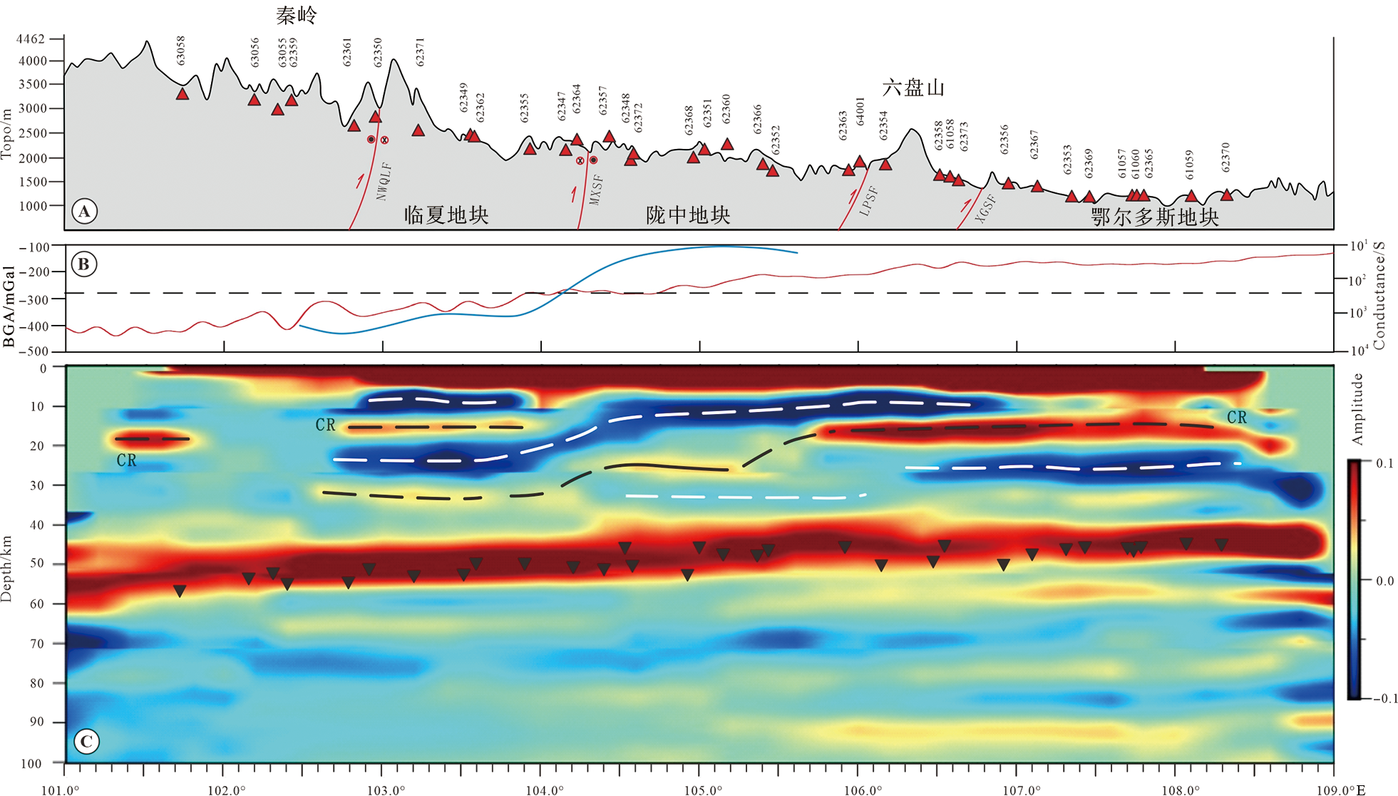
图6 研究区CCP叠加剖面结果 (叠加位置见图1实线AA' ) A—剖面地表起伏图;B—左侧标注是布格重力异常值,右侧是电导值,红色实线表示测线布格重力异常曲线,黑色虚线表示研究区平均布格重力异常值,蓝色实线表示局部电导曲线(位置见图1线4,引自文献[16]);C—共中心点叠加(CCP)剖面,黑色倒三角代表H-κ计算结果。图中缩写解释如下:NWQLF—西秦岭北缘断裂;MXSF—马衔山断裂;LPSF—六盘山断裂;XGSF—小关山断裂。
Fig.6 (a) Surface relief pattern, (b) gravity anomaly and electrical resistivity plots, and Common Conversion Point (CCP) image along line AA' (AA' location see Fig.1)

图7 研究区接收函数反演S波速度结果 (叠加位置见图1实线AA') A—剖面地表起伏图(图中缩写解释同图6A);B—复谱比法反演获得的剖面AA'的S波速度结构。
Fig.7 S-wave velocity inversion by P-wave receiver function along line AA' (AA' location see Fig.1)

图8 研究区平均地壳泊松比分布图 A—地质图(1.第四系沉积地层,2.新近系沉积地层,3.古近系沉积地层,4.下白垩统沉积地层,5.中白垩统沉积地层,6.上侏罗统沉积地层,7.侏罗纪二长花岗岩,8.侏罗纪花岗岩,9.侏罗纪石英闪长岩,10.三叠系沉积地层,11.三叠纪闪长玢岩,12.晚三叠世二长花岗岩,13.晚三叠世斑状花岗岩,14.晚三叠世石英闪长岩,15.下二叠统沉积地层,16.二叠纪花岗岩,17.石炭系沉积地层,18.石炭系基性火山岩,19.中志留统火山岩,20.上奥陶统火山岩,21.寒武系变质岩,22.古元古代变质岩);B—对应的平均地壳泊松比分布图。
Fig.8 Distribution map of average Poisson’s ratios for continental crust in the study area

图9 鄂尔多斯地块西南缘中侏罗世—早白垩世不整合接触关系图(引自文献[85⇓⇓-88,96-97,100]) A—鄂尔多斯地块西南缘白垩系地层与下伏地层的不整合接触综合图:①六盘山西麓断裂带;②海原—六盘山断裂;③青铜峡—固原断裂;④韦州—安国断裂;⑤青龙山—平凉断裂;⑥惠安堡—沙井子断裂。B—陇中地块及鄂尔多斯地块西南缘磷灰石裂变径迹热年代学反演热史模拟路径(b1陇中地块东缘西吉盆地样品;b2鄂尔多斯地块西南缘宝积山样品;b3六盘山构造带领区南华山样品;b4鄂尔多斯地块西南缘炭山样品);C—鄂尔多斯地块西南缘中生代地层柱状图;D—炭山反射地震剖面结果。
Fig.9 Middle Jurassic-Early Cretaceous unconformity relationships in the southwestern margin of the Ordos block. Modified from [85⇓⇓-88,96-97,100].
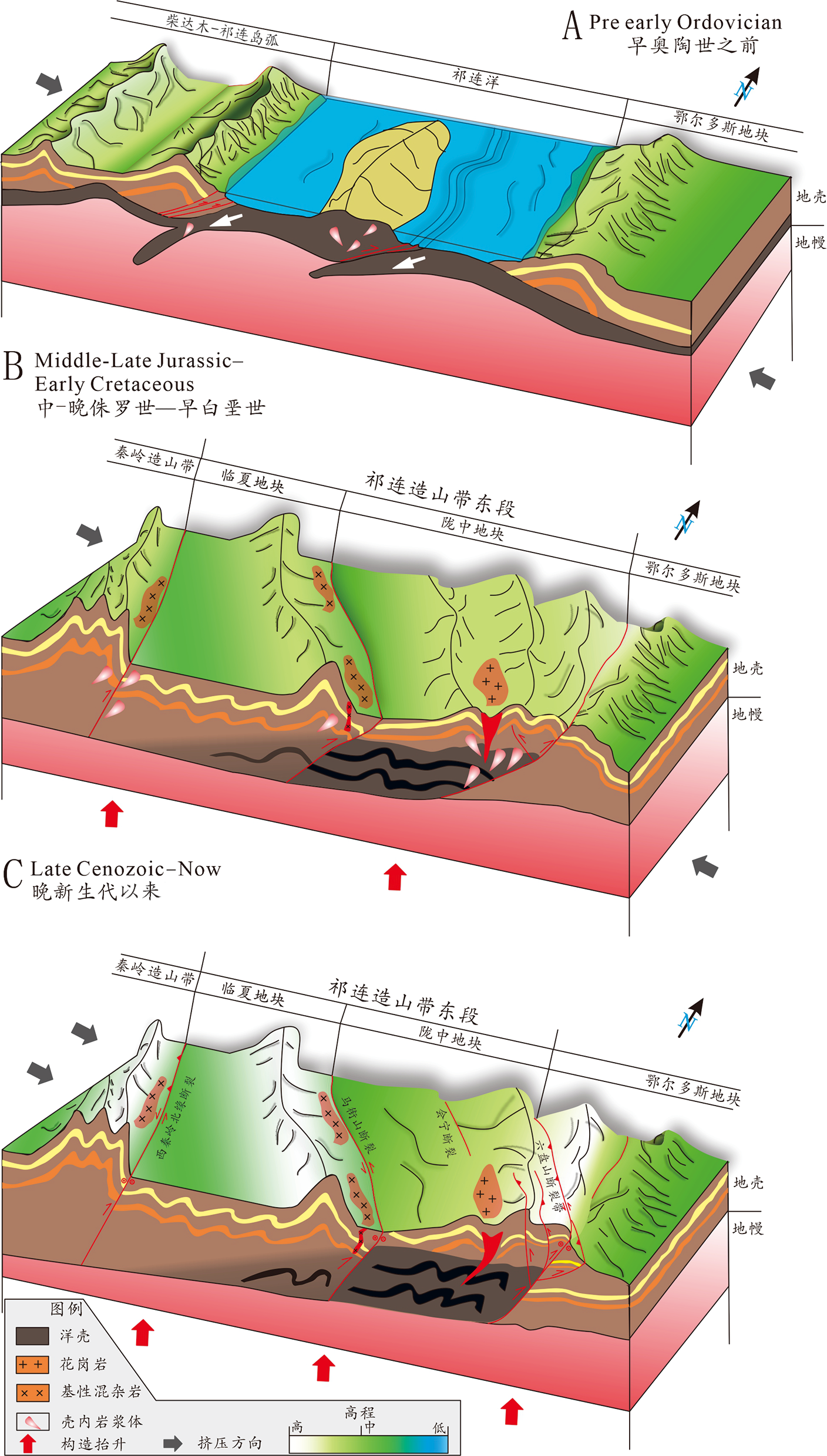
图10 构造演化模式图 A—早奥陶世之前研究区祁连洋闭合模式图;B—中侏罗世晚期—早白垩世岩石圈地壳缩短增厚过程;C—青藏高原东北缘晚新生代以来高原生长和扩展过程。
Fig.10 Structural evolution model for the study area
| [1] |
TAPPONNIER P, XU Z Q, ROGER F, et al. Oblique stepwise rise and growth of the Tibet Plateau[J]. Science, 2001, 294: 1671-1677.
PMID |
| [2] |
YIN A, HARRISON T M. Geologic evolution of the Himalayan-Tibetan Orogen[J]. Annual Review of Earth and Planetary Sciences, 2000, 28: 211-280.
DOI URL |
| [3] | 钟大赉, 丁林. 青藏高原的隆起过程及其机制探讨[J]. 中国科学: D辑, 1996, 26(4): 289-295. |
| [4] | 嵇少丞, 王茜, 杨文采. 华北克拉通泊松比与地壳厚度的关系及其大地构造意义[J]. 地质学报, 2009, 83(3): 324-330. |
| [5] |
CLARK M K, ROYDEN L H. Topographic ooze: building the eastern margin of Tibet by lower crustal flow[J]. Geology, 2000, 28(2): 703-706.
DOI URL |
| [6] |
GAO R, ZHOU H, LU Z, et al. Deep seismic reflection profile reveals the deep process of continent-continent collision on the Tibetan Plateau[J]. Earth Science Frontiers, 2022, 29(2): 14-27.
DOI |
| [7] | DING L, KAPP P, CAI F, et al. Timing and mechanisms of Tibetan Plateau uplift[J]. Nature Reviews Earth & Environment, 2022, 3(10): 652-667. |
| [8] | 童蔚蔚, 王良书, 米宁, 等. 利用接收函数研究六盘山地区地壳上地幔结构特征[J]. 中国科学: D辑, 2007(增刊): 193-198. |
| [9] |
LIU M J, MOONEY W D, LI S L, et al. Crustal structure of the northeastern margin of the Tibetan Plateau from the Songpan-Ganzi Terrane to the Ordos Basin[J]. Tectonophysics, 2006, 420(1/2): 253-266.
DOI URL |
| [10] | 陈九辉, 刘启元, 李顺成, 等. 青藏高原东北缘-鄂尔多斯地块地壳上地幔S波速度结构[J]. 地球物理学报, 2005, 48(2): 333-342. |
| [11] | 李文辉, 高锐, 王海燕, 等. 六盘山断裂带及其邻区地壳结构[J]. 地球物理学报, 2017, 60(6): 2265-2278. |
| [12] |
SONG S G, ZHANG L F, NIU Y L, et al. Evolution from oceanic subduction to continental collision: a case study from the northern Tibetan Plateau based on geochemical and geochronological data[J]. Journal of Petrology, 2006, 47(3): 435-455.
DOI URL |
| [13] |
BURCHFIEL B C, ZHANG P, WANG Y, et al. Geology of the Haiyuan Fault Zone, Ningxia-Hui Autonomous Region, China, and its relation to the evolution of the northeastern Margin of the Tibetan Plateau[J]. Tectonics, 1992, 10(6): 1091-1110.
DOI URL |
| [14] |
GAUDEMER Y, TAPPONNIER P, MEYER B, et al. Partitioning of crustal slip between linked, active faults in the eastern Qilian Shan, and evidence for a major seismic gap, the ‘Tianzhu gap’ on the western Haiyuan Fault, Gansu (China)[J]. Geophysical Journal International, 1995, 120: 599-645.
DOI URL |
| [15] |
TAYLOR M H, YIN A. Active faulting on the Tibetan Plateau and sounding regions relationships to earthquakes, contemporary strain, and late Cenozoic volcanism[J]. Geosphere, 2009, 5: 199-214.
DOI URL |
| [16] |
XIN Z H, HAN J T, GAO R, et al. Electrical structure of the eastern segment of the Qilian orogenic belt revealed by 3-D inversion of magnetotelluric data: new insights into the evolution of the northeastern margin of the Qinghai-Tibet Plateau[J]. Journal of Asian Earth Sciences, 2021, 210(2): 104707.
DOI URL |
| [17] | JIN S, ZHANG L T, JIN Y J, et al. Crustal electrical structure along the Hezuo-Dajing profile across the northeastern margin of the Tibetan Plateau[J]. Chinese Journal of Geophysics, 2012, 55(12): 3979-3990. |
| [18] | XIA S B, WANG X B, MIN G, et al. Crust and uppermost mantle electrical structure beneath Qilianshan Orogenic Belt and Alxa block in northeastern margin of the Tibetan Plateau[J]. Chinese Journal of Geophysics, 2019, 62(3): 950-966. |
| [19] | HAN S, HAN J T, LIU G X, et al. Crust and upper mantle electrical structure and tectonic deformation of the northeastern margin of the Tibetan Plateau and the adjacent Ordos Block[J]. Chinese Journal of Geophysics, 2016, 59(11): 4126-4138. |
| [20] | GUO X Y, GAO R, WANG H Y, et al. Crustal architecture beneath the Tibet-Ordos transition zone, NE Tibet, and the implications for plateau expansion[J]. Geophysical Research Letters, 2015, 42(24): 10631-10639. |
| [21] |
TIAN X B, BAI Z M, KLEMPERER S L, et al. Crustal-scale wedge tectonics at the narrow boundary between the Tibetan Plateau and Ordos block[J]. Earth and Planetary Science Letters, 2021, 554: 116700.
DOI URL |
| [22] |
ZHANG P Z, SHEN Z K, WANG M, et al. Continuous deformation of the Tibetan Plateau from global positioning system data[J]. Geology, 2004, 32: 809-812.
DOI URL |
| [23] | 张国伟, 程顺有, 郭安林, 等. 秦岭—大别中央造山系南缘勉略古缝合带的再认识: 兼论中国大陆主体的拼合[J]. 地质通报, 2004, 23(9/10): 846-853. |
| [24] |
GUO X Y, GAO R, LI S Z, et al. Lithospheric architecture and Deformation of NE Tibet: new insights on the interplay of regional tectonic processes[J]. Earth and Planetary Science Letters, 2016, 449: 89-95.
DOI URL |
| [25] | 詹艳, 杨皓, 赵国泽, 等. 青藏高原东北缘海原构造带马东山阶区深部电性结构特征及其构造意义[J]. 地球物理学报, 2017, 60(6): 2371-2384. |
| [26] |
CHENG Y Z, GAO R, LU Z W, et al. Meso-Cenozoic tectonic evolution of the Kexueshan Basin, northwestern Ordos, China: evidence from palaeo-tectonic stress fields analyses[J]. Frontiers in Earth Science, 2022, 10: 845475.
DOI URL |
| [27] | 殷鸿福, 张克信. 中央造山带的演化及其特点[J]. 地球科学: 中国地质大学学报, 1998, 23: 438-441. |
| [28] | 田勤俭, 丁国瑜. 青藏高原东北隅似三联点构造特征[J]. 中国地震, 1998, 14: 29-37. |
| [29] | 李松林, 赖晓玲. 青藏高原东北缘似三联点构造的初步研究[J]. 大地测量与地球动力学, 2006, 26: 10-14. |
| [30] | 程永志, 施炜, 赵国春, 等. 鄂尔多斯地块西缘科学山地区叠加变形分析[J]. 地球科学与环境学报, 2019, 41(2): 209-224. |
| [31] | GAN W J, ZHANG P Z, SHEN Z K, et al. Present-day crustal motion within the Tibetan Plateau inferred from GPS measurements[J]. Journal of Geophysical Research: Atmospheres-Solid Earth, 2007, 112: B08416. |
| [32] |
LI S L, MOONEY W D, FAN J C. Crustal structure of mainland China from deep seismic sounding data[J]. Tectonophysics, 2006, 420(1/2): 239-252.
DOI URL |
| [33] |
GAO R, WANG H, YIN A, et al. Tectonic development of the northeastern Tibetan Plateau as constrained by high-resolution deep seismic-reflection data[J]. Lithosphere, 2013, 5(6): 555-574.
DOI URL |
| [34] |
TIAN X B, ZHANG Z J. Bulk crustal properties in NE Tibet and their implications for deformation model[J]. Gondwana Research, 2013, 24(2): 548-559.
DOI URL |
| [35] | 刘启元, KIND R, 李顺成. 接收函数复谱比的最大或然性估计及非线性反演[J]. 地球物理学报, 1996, 39(4): 500-511. |
| [36] |
ZHANG Z J, BAI Z M, KLEMPERER S L, et al. Crustal structure across northeastern Tibet from wide-angle seismic profiling: constraints on the Caledonian Qilian orogeny and its reactivation[J]. Tectonophysics, 2013, 606: 140-159.
DOI URL |
| [37] | 滕吉文. 柴达木东盆地的深层地震反射波和地壳构造[J]. 地球物理学报, 1974, 17(2): 122-135. |
| [38] | 曾融生, 丁志峰, 吴庆举. 青藏高原岩石圈构造及动力学过程研究[J]. 地球物理学报, 1994, 37(增刊I): 99-116. |
| [39] | 崔作舟, 李秋生, 吴朝东, 等. 格尔木—额济纳旗地学断面的地壳结构与深部构造[J]. 地球物理学报, 1995, 38(增刊II): 15-28. |
| [40] |
VERGNE J, WITTLINGER G, HUI Q, et al. Seismic evidence for stepwise thickening of the crust across the NE Tibetan Plateau[J]. Earth and Planetary Sciences Letters, 2002, 203(1): 25-33.
DOI URL |
| [41] | 李秋生, 澎苏萍, 高锐, 等. 东昆仑大地震的深部构造背景[J]. 地球学报, 2004, 25(1): 11-16. |
| [42] | KARPLUS M S, ZHAO W, KLEMPERER S L, et al. Injection of Tibetan crust beneath the south Qaidam Basin: evidence from INDEPTH IV wide-angle seismic data[J]. Journal of Geophysical Research: Atmospheres, 2011, 116: B07301. |
| [43] |
ZHANG Z J, KLEMPERER S, BAI Z M, et al. Crustal structure of the Paleozoic Kunlun orogeny from an active-source seismic profile between Moba and Guide in East Tibet, China[J]. Gondwana Research, 2011, 19(4): 994-1007.
DOI URL |
| [44] |
ZHENG D W, CLARK M K, ZHANG P Z, et al. Erosion, fault initiation and topographic growth of the North Qilian Shan (northern Tibetan Plateau)[J]. Geosphere, 2010, 6: 937-941.
DOI URL |
| [45] | 嘉世旭, 张先康, 赵金仁, 等. 若尔盖盆地及周缘褶皱造山带地壳结构: 深地震测深结果[J]. 中国科学: 地球科学, 2009, 39(9): 1200-1208. |
| [46] | WANG Q, GAO Y, SHI Y T, et al. Seismic anisotropy in the uppermost mantle beneath the northeastern margin of Qinghai-Tibet Plateau: evidence from shear wave splitting of SKS, PKS and SKKS[J]. Chinese Journal of Geophysics, 2013, 56(3): 892-905. |
| [47] | 刘明军, 李松林, 方盛明, 等. 利用地震波速研究青藏高原东北缘地壳组成及其动力学[J]. 地球物理学报, 2008, 51(2): 412-430. |
| [48] |
GALVÉ A, HIRN A, JIANG M, et al. Modes of raising northeastern Tibet probed by explosion seismology[J]. Earth and Planetary Science Letters, 2002, 203(1): 35-43.
DOI URL |
| [49] | 李永华, 吴庆举, 安张辉, 等. 青藏高原东北缘地壳S波速度结构与泊松比及其意义[J]. 地球物理学报, 2006, 49(5): 1359-1368, |
| [50] | 徐强, 赵俊猛. 接收函数方法的研究综述[J]. 地球物理学进展, 2008, 23: 1709-1716. |
| [51] | 陈凌, 王旭, 王新, 等. 接收函数界面和波速成像研究进展与展望[J]. 地球与行星物理论评, 2022, 53(6): 1-22. |
| [52] | AMMON C J, RANDALL G E, ZANDT G. On the nonuniqueness of Receiver function inversions[J]. Journal of Geophysical Research: Solid Earth, 1990, 95(B10): 15303-15318. |
| [53] |
LANGSTON C A. Structure under Mount Rainier, Washington, inferred from teleseismic body waves[J]. Journal of Geophysical Research, 1979, 84(B9): 4749-4762.
DOI URL |
| [54] | TIAN X B, WU Q J, ZHANG Z J, et al. Joint imaging by teleseismic converted and multiple waves and its application in the INDEPTH-III passive seismic array[J]. Geophysical Research Letters, 2005, 32(10): 1029-2005. |
| [55] |
OWENS T J, ZANDT G. Implications of crustal property variations for model of Tibetan Plateau evolution[J]. Nature, 1997, 387: 37-43.
DOI |
| [56] |
YU C Q, ZHENG Y C, SHANG X F. Crazyseismic: a MATLAB GUI-based software package for passive seismic data preprocessing[J]. Seismological Research Letters, 2017, 88(2A): 410-415.
DOI URL |
| [57] |
LIGORRIA J P, AMMON C J. Iterative deconvolution and receiver function estimation[J]. Bulletin of the seismological Society of America, 1999, 89(5): 1395-1400.
DOI URL |
| [58] |
ZHU L P, KANAMORI H. Moho depth variation in southern California from teleseismic receiver functions[J]. Journal of Geophysical Research, 2000, 105: 2969-2980.
DOI URL |
| [59] | CHEN Y L NIU, F L, LIU R F, et al. Crustal structure beneath China from receiver function analysis[J]. Journal of Geophysical Research: Solid Earth, 2010, 115(B3): B03307. |
| [60] |
TENG J W, ZHANG Z J, ZHANG X K, et al. Investigation of the Moho discontinuity beneath the Chinese mainland using deep seismic sounding profiles[J]. Tectonophysics, 2013, 609: 202-216.
DOI URL |
| [61] | 高锐, 马永生, 李秋生, 等. 松潘地块与西秦岭造山带下地壳的性质和关系: 深地震反射剖面的揭露[J]. 地质通报, 2006, 25(12): 1361-1367. |
| [62] | 高锐, 王海燕, 王成善, 等. 青藏高原东北缘岩石圈缩短变形-深地震反射剖面再处理提供的证据[J]. 地球学报, 2011, 32(5): 513-520. |
| [63] | KENNETT B L N, ENGDAHL E R. Travelimes for global earhquake locatin and phase ienfication[J]. Geophysical Journal Intermational, 1991, 105(2): 429-465. |
| [64] |
WANG C Y, SANDVOL E, ZHU L, et al. Lateral variation of crustal structure in the Ordos block and surrounding regions, North China, and its tectonic implications[J]. Earth and Planetary Sciences Letters, 2014, 387: 198-211.
DOI URL |
| [65] | 王兴臣, 丁志峰, 武岩, 等. 中国南北地震带北段及其周缘地壳厚度与泊松比研究[J]. 地球物理学报, 2017, 60(6): 2080-2090. |
| [66] | 张国伟, 孟庆任, 赖绍聪. 秦岭造山带的结构构造[J]. 中国科学(B辑), 1995, 25(9): 994-1003. |
| [67] | 程顺有, 张国伟, 李立. 秦岭造山带岩石圈电性结构及其地球动力学意义[J]. 地球物理学报, 2003, 46(3): 390-397. |
| [68] | 刘启民, 赵俊猛, 卢芳, 等. 用接收函数方法反演青藏高原东北缘地壳结构[J]. 中国科学: 地球科学, 2014, 44: 668-679. |
| [69] | 郭晓玉, 高锐, 高建荣, 等. 青藏高原东北缘马衔山断裂带构造属性的综合研究[J]. 地球物理学报, 2018, 61(2): 560-569. |
| [70] | 陈一方, 陈九辉, 郭飚, 等. 鄂尔多斯西缘北段的地壳结构和块体间变形关系[J]. 地球物理学报, 2020, 63(3): 886-896. |
| [71] |
CHRISTENSEN N I. Poisson’s ratio and crustal seismology[J]. Journal of Geophysical Research, 1996, 101(B2) : 3139-3156.
DOI URL |
| [72] | 宫猛, 李信富, 张素欣, 等. 利用接收函数研究河北及邻区地壳厚度与泊松比分布特征[J]. 地震, 2015, 35(2): 34-42. |
| [73] |
CHENG H, LU T Y, CAO D D. Coupled Lu-Hf and Sm-Nd geochronology constrains blueschist-facies metamorphism and closure timing of the Qilian Ocean in the North Qilian orogen[J]. Gondwana Research, 2016, 34: 99-108.
DOI URL |
| [74] |
DARBY B J, RITTS B D. Mesozoic contractional deformation in the middle of the Asian tectonic collage: the intraplate Western Ordos fold-thrust belt, China[J]. Earth and Planetary Sciences Letters, 2002, 205: 13-24.
DOI URL |
| [75] |
HART S R, GLASSLEY W E, KARIG D E. Basalts and sea floor spreading behind the Mariana island arc[J]. Earth and Planetary Sciences Letters, 1972, 15(1): 12-18.
DOI URL |
| [76] | HE S P, WANG H L, CHEN J L, et al. LA-ICPMS U-Pb zircon geochronology of basic dikes within maxianshan rock group in the central Qilian Mountains and its tectonic implications[J]. Journal of China University of Geosciences, 2008, 33(1): 35-45. |
| [77] |
XIAO W J, WINDLEY B F, YONG Y, et al. Early Paleozoic to Devonian multiple-accretionary model for the Qilian Shan, NW China[J]. Journal of Asian Earth Sciences, 2009, 35(3/4): 323-333.
DOI URL |
| [78] | 裴先治, 刘会彬, 丁仨平, 等. 西秦岭天水地区李子园群变质火山岩的地球化学特征及其地质意义[J]. 大地构造与成矿学, 2006, 30(2): 193-205. |
| [79] |
WU H Q, FENG Y M, SONG S G. Metamorphism and deformation of blueschist belts and their tectonic implications, North Qilian Mountains, China[J]. Journal of Metamorphic Geology, 1993, 11(4): 523-536.
DOI URL |
| [80] |
XU Z Q, XU H F, ZHANG J X, et al. Proliferating terrane and its dynamics of the Caledonian subduction complex in the Nanshan Mountains, North Qilian Corridor[J]. Acta Geologica Sinica, 1994, 7(3): 225-241.
DOI URL |
| [81] |
YANG J S, XU Z Q, ZHANG J X, et al. Early Palaeozoic North Qaidam UHP metamorphic belt on the north-eastern Tibetan Plateau and a paired subduction model[J]. Terra Nova, 2002, 14(5): 397-404.
DOI URL |
| [82] |
LIN X, CHEN H, WYRWOLL K H, et al. The uplift history of the Haiyuan-Liupan Shan region northeast of the present Tibetan Plateau: integrated constraint from stratigraphy and thermochronology[J]. The Journal of Geology, 2011, 119(4): 372-393.
DOI URL |
| [83] |
DONG Y, SANTOSH M. Tectonic architecture and multiple orogeny of the Qinling orogenic belt, central China[J]. Gondwana Research, 2016, 29: 1-40.
DOI URL |
| [84] | PENG H, WANG J, ZATTIN M, et al. Late Triassic-early Jurassic uplifting in eastern Qilian mountain and its geological significance: evidence from apatite fission track thermochronology[J]. Journal of China University of Geosciences, 2018, 43: 1983-1996. |
| [85] |
PENG H, WANG J, LIU C, et al. Thermochronological constraints on the Meso-Cenozoic tectonic evolution of the Haiyuan-Liupanshan region, northeastern Tibetan Plateau[J]. Journal of Asian earth Sciences, 2019, 183: 103966.
DOI URL |
| [86] | TANG X, GUO Z, CHEN H, et al. The study and petroleum prospect of thrust nappe in the west margin of Shaanxi-Gansu-Ningxia Basin[M]. Xi’an: Northwest University Press, 1992. |
| [87] |
GUO P, LIU C Y, WANG J Q, et al. Detrital zircon geochronology of the Jurassic strata in the western Ordos Basin, North China: constraints on the provenance and its tectonic implication[J]. Geological Journal, 2018, 53: 1482-1499.
DOI URL |
| [88] | PENG H, LIU X, LIU C, et al. Spatialtemporal evolution and the dynamic background of the translation of Mid-Late Mesozoic tectonic regimes of the Southwest Ordos Basin margin[J]. Acta Geologica Sinica, 2022, 96: 387-402. |
| [89] |
GEHRELS G E, YIN A, WANG X F. Detrital-zircon geochronology of the northeastern Tibetan Plateau[J]. Geological Society of America Bulletin, 2003, 115(7): 881-896.
DOI URL |
| [90] |
SONG S G, NIU Y L, SU L, et al. Tectonics of the North Qilian orogen, NW China[J]. Gondwana Research, 2013, 23(4): 1378-1401.
DOI URL |
| [91] |
ANDREW V Z, CHEN W, WANG Z Z. Underthrusting and duplexing beneath the northern Tibetan Plateau and the evolution of the Himalayan-Tibetan oragen[J]. Lithosphere, 2019, 11(2): 209-231.
DOI URL |
| [92] |
GUO P, LIU C, WANG J, et al. Detrital-zircon geochronology of the Jurassic coal-bearing strata in the western Ordos Basin, North China: evidences for multi-cycle sedimentation[J]. Geoscience Frontiers, 2018, 9: 1725-1743.
DOI URL |
| [93] |
ZHAO J, LIU C, HUANG L, et al. Paleogeography reconstruction of a multi-stage modified intra-cratonic basin: a case study from the Jurassic Ordos Basin, western North China Craton[J]. Journal of Asian earth Sciences, 2019, 190: 104191.
DOI URL |
| [94] | 刘池洋, 赵红格, 王锋, 等. 鄂尔多斯盆地西缘(部)中生代构造属性[J]. 地质学报, 2005, 79(6): 737-747. |
| [95] |
WANG G Z, LI S Z, LI X Y, et al. Destruction effect on Meso-Neoproterozoic oil-gas traps derived from Meso-Cenozoic deformation in the North China Craton[J]. Precambrian Research, 2019, 333: 105427.
DOI URL |
| [96] |
DUVALL A R, CLARK M K, KIRBY E, et al. Low-temperature thermochronometry along the Kunlun and Haiyuan faults, NE Tibetan Plateau: evidence for kinematic change during late-stage orogenesis[J]. Tectonics, 2013, 32: 1190-1211.
DOI URL |
| [97] | SONG L J, MOU Q H, LI A R, et al. Fission-track thermal evolution history in the formation age of Yaoshan Formation[J]. Coal Geology & Exploration, 2013, 41(4): 1-4. |
| [98] |
REN Z, XIAO H, LIU L, et al. The evidence of fission-track data for the study of tectonic thermal history in Qinshui Basin[J]. Chinese Science Bulletin, 2005, 50: 104-110.
DOI URL |
| [99] | REN Z, YU Q, CUI J, et al. Thermal history and its controls on the oil and gas of the Ordos Basin[J]. Earth Science Frontiers, 2017, 24: 137-148. |
| [100] |
PENG H, WANG J, LIU C, et al. Meso-Cenozoic growth of the eastern Qilian Shan, northeastern Tibetan Plateau margin: insight from borehole apatite fission-track thermochronology in the Xiji Basin[J]. Marine and Petroleum Geology, 2022, 143: 105798.
DOI URL |
| [101] |
KAPP P, DECELLES P G, GEHRELS G E, et al. Geological records of the Lhasa-Qiangtang and Indo-Asian collisions in the Nima area of central Tibet[J]. Geological Society of America Bulletin, 2007, 119: 917-933.
DOI URL |
| [102] |
ZHU D C, LI S M, CAWOOD P A, et al. Assembly of the Lhasa and Qiangtang terranes in central Tibet by divergent double subduction[J]. Lithos, 2016, 245: 7-17.
DOI URL |
| [103] |
DONG S W, ZHANG Y Q, LI H L, et al. The Yanshan orogeny and late mesozoic multi-plate convergence in East Asia Commemorating 90th years of the Yanshan orogeny[J]. Science China: Earth Sciences, 2018, 61: 1888-1909.
DOI |
| [104] | WANG J Q. Reconstruction of the Early Crataceous Basin and its evolution in Southwest Ordos[D]. Xi’an: Northwest University, 2007: 1-84. |
| [105] |
PENG H, WANG J, LIU C, et al. Mesozoic exhumation and ca. 10 Ma reactivation of the southern Yin Shan, North China, revealed by low-temperature thermochronology[J]. Tectonophysics, 2022, 823: 229189.
DOI URL |
| [106] | 王伟涛, 张培震, 郑德文, 等. 青藏高原东北缘海原断裂带晚新生代构造变形[J]. 地学前缘, 2014, 21(4): 266-274. |
| [107] |
ZHENG D W, ZHANG P Z, WAN J L, et al. Rapid exhumation at -8 Ma on the Liupan Shan thrust fault from apatite fission-track thermochronology: implications for growth of the northeastern Tibetan Plateau margin[J]. Earth Planetary Science Letters, 2006, 248(1/2): 198-208.
DOI URL |
| [108] | 赵俊峰, 刘池洋, 梁积伟, 等. 鄂尔多斯盆地直罗组—安定组沉积期原始边界恢复[J]. 地质学报, 2010, 84(4): 553-569. |
| [109] |
WANG W T, KIRBY E, ZHANG P Z, et al. Tertiary basin evolution along the northeastern margin of the Tibetan Plateau: evidence for basin formation during Oligocene transtension[J]. Geological Society of America Bulletin, 2013, 125(3/4): 377-400.
DOI URL |
| [110] | DUEKER K G, SHEEHAN A F. Mantle discontinuity structure from midpoint stacks of converted P to S waves across the Yellowstone hotspot track[J]. Journal of Geophysical Research: Solid Earth, 1997, 102(B4): 8313-8327. |
| [111] |
周鹏哲, 高锐, 叶卓. 祁连山中部地壳各向异性研究: 来自远震接收函数的证据[J]. 地学前缘, 2022, 29(4): 265-277.
DOI |
| [112] |
李文辉, 王海燕, 高锐, 等. 秦岭造山带及邻区上地壳精细速度结构研究[J]. 地学前缘, 2022, 29(2): 198-209.
DOI |
| [1] | 蔡蔚, 卢占武, 黄荣, 李文辉, 罗银河, 王光文, 穆青, 程永志, 陈司, 王冠, 陈子龙. 基于短周期密集台阵接收函数揭示的藏南错那洞穹窿地壳结构[J]. 地学前缘, 2024, 31(1): 170-180. |
| [2] | 姜小欢, 黄荣, 朱露培, 卢占武, 罗银河, 张荣堂, 徐浩. RF-RTM成像方法研究新疆西准噶尔地区线性台阵下方地壳结构[J]. 地学前缘, 2023, 30(5): 358-368. |
| [3] | 穆青, 黄荣, 严加永, 卢占武, 罗银河, 张永谦, 姜小欢, 文宏斌, 魏鹏龙, 周万里. 利用接收函数H-κ-c叠加方法约束武陵山重力梯度带地壳结构[J]. 地学前缘, 2023, 30(5): 369-383. |
| [4] | 李强, 吴建平. 中国大陆东南缘地壳厚度与泊松比及其构造意义[J]. 地学前缘, 2023, 30(5): 408-419. |
| [5] | 仝霄飞, 徐啸, 郭晓玉, 李春森, 向波, 余嘉豪, 罗旭聪, 袁梓昭, 林燕琪, 时宏城. 接收函数成像揭示东昆仑断裂带及其周缘地壳结构[J]. 地学前缘, 2023, 30(4): 270-282. |
| [6] | 徐啸, 余嘉豪, 向波, 郭晓玉, 李春森, 罗旭聪, 仝霄飞, 袁梓昭, 林燕琪, 时宏城. 拉萨地体东南缘地壳深部结构[J]. 地学前缘, 2023, 30(3): 221-232. |
| [7] | 李春森, 徐啸, 向波, 郭晓玉, 吴优, 吴佳杰, 罗旭聪, 余嘉豪, 仝霄飞, 袁梓昭, 林燕琪. 北喜马拉雅构造带东部Moho形态研究:以接收函数3DCCP方法为例[J]. 地学前缘, 2023, 30(2): 57-67. |
| [8] | 周鹏哲, 高锐, 叶卓. 祁连山中部地壳各向异性研究:来自远震接收函数的证据[J]. 地学前缘, 2022, 29(4): 265-277. |
| [9] | 吴佳杰, 徐啸, 郭晓玉, 卢占武, 吴优, 向波, 于洋, 李春森, 余嘉豪, 仝霄飞, 罗旭聪. 喜马拉雅造山带东段错那裂谷的地壳结构[J]. 地学前缘, 2022, 29(4): 221-230. |
| [10] | Valentina V. MORDVINOVA, Maria A. KHRITOVA, Elena A. KOBELEVA, Mikhail M. KOBELEV, Evgeniy Kh. TURUTANOV, Victor S. KANAYKIN. 远震数据显示贝加尔裂谷带北穆伊斯克(Severomuysk)段地壳和上地幔的精细结构[J]. 地学前缘, 2022, 29(2): 378-392. |
| [11] | 郭进京, 赵海涛, 刘重庆, 吴彦旺. 青藏高原东北缘何时卷入现今青藏高原构造系统?——来自西秦岭北缘漳县盆地新生代沉积记录的约束[J]. 地学前缘, 2021, 28(5): 337-361. |
| [12] | 姜素华,高嵩,李三忠,曹伟,汪刚,张慧璇,赵斐宇. 西太平洋洋陆过渡带重磁异常与构造格架[J]. 地学前缘, 2017, 24(4): 152-170. |
| [13] | 王伟涛,张培震,郑德文,庞建章. 青藏高原东北缘海原断裂带晚新生代构造变形[J]. 地学前缘, 2014, 21(4): 266-274. |
| [14] | 梁浩, 张珂, 傅建利, 李庶波, 陈俊, 路凯. 青藏高原东北缘牛首山地区新构造运动及黄河演化[J]. 地学前缘, 2013, 20(4): 182-189. |
| [15] | 马收先, 张岳桥, 李海龙, 李建华, 李勇. 青藏高原东北缘新近纪晚期构造挤出:来自西秦岭地区安化—成县盆地的证据[J]. 地学前缘, 2013, 20(4): 58-74. |
| 阅读次数 | ||||||
|
全文 |
|
|||||
|
摘要 |
|
|||||