地学前缘 ›› 2023, Vol. 30 ›› Issue (4): 270-282.DOI: 10.13745/j.esf.sf.2023.4.20
所属专题: 印度-欧亚大陆碰撞及其远程效应
• “印度-欧亚大陆碰撞及其远程效应”专栏之八 • 上一篇 下一篇
仝霄飞1( ), 徐啸1,2,*(), 郭晓玉1,2, 李春森1, 向波1, 余嘉豪1, 罗旭聪1, 袁梓昭1, 林燕琪1, 时宏城1
收稿日期:2023-03-06
修回日期:2023-03-20
出版日期:2023-07-25
发布日期:2023-07-07
通信作者:
*徐 啸(1980—),男,副教授,硕士生导师,主要从事青藏高原构造地球物理学研究。E-mail: xuxiao8@mail.sysu.edu.cn
作者简介:仝霄飞(1998—),男,硕士研究生,地球物理学专业。E-mail: tongxf@mail2.sysu.edu.cn
基金资助:
TONG Xiaofei1(), XU Xiao1,2,*(), GUO Xiaoyu1,2, LI Chunsen1, XIANG Bo1, YU Jiahao1, LUO Xucong1, YUAN Zizhao1, LIN Yanqi1, SHI Hongcheng1
Received:2023-03-06
Revised:2023-03-20
Online:2023-07-25
Published:2023-07-07
摘要:
前人的研究结果表明,自中新世以来青藏高原持续进行着穿时性的向东逃逸,而东昆仑断裂的左旋走滑运动正是这种变形的表现。正确地厘定断裂的位置与地壳结构,对于更加深入地认识高原的变形、应力传递和物质运输起着至关重要的作用。有大地测量学和地貌学研究指出,东昆仑断裂沿走向向东的滑移速率逐渐递减,在被第四纪沉积物所覆盖的若尔盖盆地内尤为明显。然而,该盆地分布有广袤的高山草甸、低洼沼泽,使得通过地表追踪断裂的地貌学迹象研究尤为困难。因此,东昆仑断裂带在若尔盖盆地内的位置无法确认。本次研究采用了由167个间隔约1 km的短周期地震仪站组成的密集阵列以及9个宽频带台站,对若尔盖盆地内东昆仑断裂的地壳结构进行成像。通过比较地壳中地层的不连续性和莫霍面的深度变化,确定了东昆仑断裂在若尔盖盆地内继续向东延伸。此外,塔藏断裂和东昆仑断层在地壳结构上的相似性说明它们之间存在继承关系。高分辨率的接收函数结构为高原的向外生长提供了新的证据。
中图分类号:
仝霄飞, 徐啸, 郭晓玉, 李春森, 向波, 余嘉豪, 罗旭聪, 袁梓昭, 林燕琪, 时宏城. 接收函数成像揭示东昆仑断裂带及其周缘地壳结构[J]. 地学前缘, 2023, 30(4): 270-282.
TONG Xiaofei, XU Xiao, GUO Xiaoyu, LI Chunsen, XIANG Bo, YU Jiahao, LUO Xucong, YUAN Zizhao, LIN Yanqi, SHI Hongcheng. Receiving function imaging reveals the crustal structure of the East Kunlun fault zone and surrounding areas[J]. Earth Science Frontiers, 2023, 30(4): 270-282.

图1 东昆仑断裂前人研究成果总结 (地震学剖面的莫霍面深度数据分别来自:1、5—[23];2—[24];3—[25];4—[26];6—[27];7—[28];8—[29];9—[22];10—[30];11—[20];年代学数据来自[31⇓⇓-34]) a—东昆仑断裂活动性与前人地震学剖面总结 ;F1—东昆仑断裂;F2—塔藏断裂;F3—白龙江断裂;F4—光盖山断裂;F5—西秦岭断裂;F6—岷江断裂;F7—共和南山断裂;F8—鄂拉山断裂;F9—日月山断裂;b—东昆仑断裂地壳结构特征总结。
Fig.1 (a) Summary of previous results on the eastern Kunlun fault (Moho depth data adapted from [20,22⇓⇓⇓⇓⇓⇓⇓-30]; fault ages adapted from [31⇓⇓-34]), and (b) structural characteristics of the Earth’s crust beneath the eastern Kunlun fault.

图2 研究区域地质构造概况 (b据[58]补充修改) a—地震事件分布;b—研究区地质构造与地震台站分布图;F10—阿万仓断裂;F11—龙日坝断裂;F12—虎牙断裂。
Fig.2 (a) Distribution of seismic events used for the receiver function calculation, and (b) geological settings in the research area (modified from [58]) and distribution of seismic stations.

图3 宽频带地震仪接收函数 a—各种剖面位置与50 km深度穿刺点分布;b—经过时深转换与射线路径校正后的宽频带接收函数并按照后方位角排列,每个台站波形最上方为总的叠加结果。
Fig.3 (a) Location of CCP stacking profiles and shot-points, and (b) stacked and individual moveout corrected receiver functions plotted along backazimuth for broadband stations
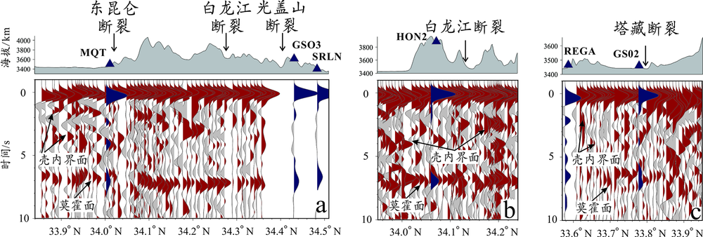
图4 原始接收函数CCP叠加剖面 a, b, c—分别为图3a中的CCP叠加剖面的接收函数叠加波形,分别按照自西向东的顺序排列,其中红色为短周期地震仪,蓝色为宽频带地震仪,并标注有对应的台站名称。
Fig.4 Raw receiver function CCP stacking profiles (profile locations see Fig.3a)
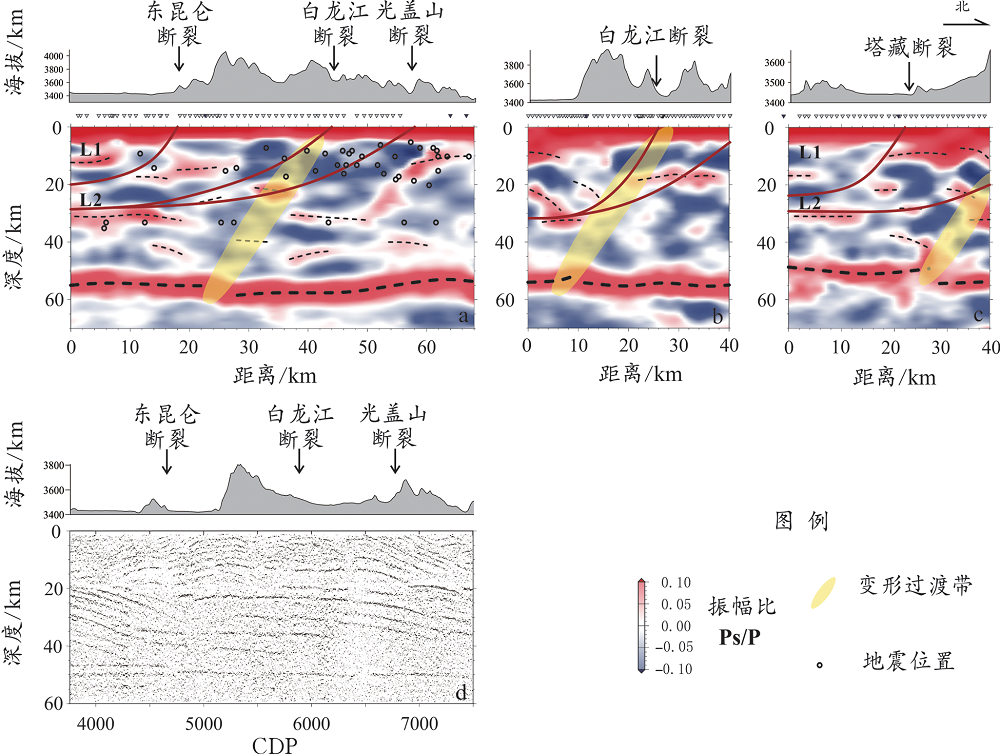
图5 共转换点叠加剖面 (d据文献[22]修改) a,b,c—分别为图3a中的CCP剖面按自西向东的顺序排列,d为图3a中的深地震反射剖面;剖面a中的圆点为周缘地震的深度投影,地震目录源自美国国家地震监测台网与中国地震台网中心,黄色区域为两个块体分界的过渡带。
Fig.5 CCP stacking profiles (profile locations see Fig.3a, d modified from [22])

图6 青藏高原东缘若尔盖盆地内生长变形模型
Fig.6 A deformation model for the Roergai Basin, eastern margin of the Tibetan Plateau
| [1] |
TAPPONNIER P, PELTZER G, ARMIJO R. On the mechanics of the collision between India and Asia[J]. Geological Society, London, Special Publications, 1986, 19(1): 113-157.
DOI URL |
| [2] |
DEWEY J F, SHACKLETON R M, CHENGFA C, et al. The tectonic evolution of the Tibetan Plateau[J]. Philosophical Transactions of the Royal Society of London Series A, Mathematical and Physical Sciences, 1988, 327(1594): 379-413.
DOI URL |
| [3] |
ROYDEN LEIGH H, BURCHFIEL B C, VAN DER HILST ROBERT D. The geological evolution of the Tibetan Plateau[J]. Science, 2008, 321(5892): 1054-1058.
DOI PMID |
| [4] |
李春森, 徐啸, 向波, 等. 北喜马拉雅构造带东部Moho形态研究: 以接收函数3DCCP方法为例[J]. 地学前缘, 2023, 30(2): 57-67.
DOI |
| [5] |
郭晓玉, 罗旭聪, 高锐, 等. 印度-欧亚板块主碰撞带全地壳尺度相互作用关系研究[J]. 地学前缘, 2023, 30(2): 1-17.
DOI |
| [6] |
TAPPONNIER P. Oblique stepwise rise and growth of the Tibet Plateau[J]. Science, 2001, 294(5547): 1671-1677.
PMID |
| [7] |
吴佳杰, 徐啸, 郭晓玉, 等. 喜马拉雅造山带东段错那裂谷的地壳结构[J]. 地学前缘, 2022, 29(4): 221-230.
DOI |
| [8] | TAPPONNIER P. Propagating extrusion tectonics in Asia: new insights from simple experiments with plasticine[J]. 1982, 10(12): 611-616. |
| [9] | HOUSEMAN G, ENGLAND P. Crustal thickening versus lateral expulsion in the Indian-Asian continental collision[J]. Journal of Geophysical Research: Solid Earth, 1993, 98(B7): 12233-12249. |
| [10] |
ROYDEN LEIGH H, BURCHFIEL B C, KING ROBERT W, et al. Surface deformation and lower crustal flow in eastern Tibet[J]. Science, 1997, 276(5313): 788-790.
PMID |
| [11] |
ZHU L, JI L, LIU C. Interseismic slip rate and locking along the Maqin-Maqu segment of the east Kunlun fault, northern Tibetan Plateau, based on Sentinel-1 images[J]. Journal of Asian Earth Sciences, 2021, 211: 104703.
DOI URL |
| [12] |
VAN DER WOERD J, TAPPONNIER P, RYERSON F J, et al. Uniform postglacial slip-rate along the central 600 km of the Kunlun fault (Tibet), from 26Al, 10Be, and 14C dating of riser offsets, and climatic origin of the regional morphology[J]. Geophysical Journal International, 2002, 148(3): 356-388.
DOI URL |
| [13] |
VAN DER WOERD J, RYERSON F J, TAPPONNIER P, et al. Uniform slip-rate along the Kunlun fault: implications for seismic behaviour and large-scale tectonics[J]. Geophysical Research Letters, 2000, 27(16): 2353-2356.
DOI URL |
| [14] |
HARKINS N, KIRBY E, SHI X, et al. Millennial slip rates along the eastern Kunlun fault: implications for the dynamics of intracontinental deformation in Asia[J]. Lithosphere, 2010, 2(4): 247-266.
DOI URL |
| [15] | KIRBY E, HARKINS N, WANG E, et al. Slip rate gradients along the eastern Kunlun fault[J]. Tectonics, 2007, 26(2). https://doi.org/10.1029/2006tc002033. |
| [16] | 李陈侠, 徐锡伟, 闻学泽, 等. 东昆仑断裂东段玛沁—玛曲段几何结构特征[J]. 地震地质, 2009, 31(3): 441-458. |
| [17] | 李建军, 蔡瑶瑶, 张军龙. 东昆仑断裂带东段塔藏断裂几何结构及滑动递减模型讨论[J]. 地震, 2019, 39(1): 20-28. |
| [18] |
KIRBY E, HARKINS N. Distributed deformation around the eastern tip of the Kunlun fault[J]. International Journal of Earth Sciences, 2013, 102(7): 1759-1772.
DOI URL |
| [19] | XU X, GAO R, DONG S, et al. Lateral extrusion of the northern Tibetan Plateau interpreted from seismic images, potential field data, and structural analysis of the eastern Kunlun fault[J]. Tectonophysics, 2017, 696-697: 88-98. |
| [20] |
LIU Z, TIAN X, GAO R, et al. New images of the crustal structure beneath eastern Tibet from a high-density seismic array[J]. Earth and Planetary Science Letters, 2017, 480: 33-41.
DOI URL |
| [21] | DUVALL, ALISON R, et al. Dissipation of fast strike-slip faulting within and beyond northeastern Tibet[J]. Geology, 2010, 3: 223-226. |
| [22] |
GAO R, WANG H, ZENG L, et al. The crust structures and the connection of the Songpan block and West Qinling orogen revealed by the Hezuo-Tangke deep seismic reflection profiling[J]. Tectonophysics, 2014, 634: 227-236.
DOI URL |
| [23] | 赵荣涛, 赵文津, 史大年, 等. 可可西里岩石圈向北俯冲到柴达木地幔的地震学证据[J]. 地球物理学报, 2020, 63(8): 2940-2953. |
| [24] |
ZHAO W, KUMAR P, MECHIE J, et al. Tibetan plate overriding the Asian plate in central and northern Tibet[J]. Nature Geoscience, 2011, 4(12): 870-873.
DOI |
| [25] |
KARPLUS M S, KLEMPERER S L, ZHAO W, et al. Receiver-function imaging of the lithosphere at the Kunlun-Qaidam boundary, Northeast Tibet[J]. Tectonophysics, 2019, 759: 30-43.
DOI URL |
| [26] | KARPLUS M S, ZHAO W, KLEMPERER S L, et al. Injection of Tibetan crust beneath the south Qaidam Basin: evidence from INDEPTH IV wide-angle seismic data[J]. Journal of Geophysical Research, 2011, 116(B7). https://doi.org/10.1029/2010jb007911. |
| [27] |
VERGNE J, WITTLINGER G, HUI Q, et al. Seismic evidence for stepwise thickening of the crust across the NE Tibetan plateau[J]. Earth and Planetary Science Letters, 2002, 203(1): 25-33.
DOI URL |
| [28] |
XU T, WU Z, ZHANG Z, et al. Crustal structure across the Kunlun fault from passive source seismic profiling in east Tibet[J]. Tectonophysics, 2014, 627: 98-107.
DOI URL |
| [29] |
WANG X, CHEN L, AI Y, et al. Crustal structure and deformation beneath eastern and northeastern Tibet revealed by P-wave receiver functions[J]. Earth and Planetary Science Letters, 2018, 497: 69-79.
DOI URL |
| [30] |
YE Z, GAO R, LI Q, et al. Seismic evidence for the North China plate underthrusting beneath northeastern Tibet and its implications for plateau growth[J]. Earth and Planetary Science Letters, 2015, 426: 109-117.
DOI URL |
| [31] |
YUAN D Y, CHAMPAGNAC J D, GE W P, et al. Late Quaternary right-lateral slip rates of faults adjacent to the lake Qinghai, northeastern margin of the Tibetan Plateau[J]. Geological Society of America Bulletin, 2011, 123(9/10): 2016-2030.
DOI URL |
| [32] |
LI H, ZHANG Y, DONG S, et al. Neotectonics of the Bailongjiang and Hanan faults: new insights into late Cenozoic deformation along the eastern margin of the Tibetan Plateau[J]. GSA Bulletin, 2020, 132(9/10): 1845-1862.
DOI URL |
| [33] |
DUVALL A R, CLARK M K, KIRBY E, et al. Low-temperature thermochronometry along the Kunlun and Haiyuan faults, NE Tibetan Plateau: evidence for kinematic change during late-stage orogenesis[J]. Tectonics, 2013, 32(5): 1190-1211.
DOI URL |
| [34] |
TIAN Y, LI R, TANG Y, et al. Thermochronological constraints on the Late Cenozoic morphotectonic evolution of the Min Shan, the eastern margin of the Tibetan Plateau[J]. Tectonics, 2018, 37(6): 1733-1749.
DOI URL |
| [35] |
SENGOR A M C, YILMAZ Y, SUNGURLU O. Tectonics of the Mediterranean Cimmerides: nature and evolution of the western termination of Palaeo-Tethys[J]. Geological Society, London, Special Publications, 1984, 17: 77-112.
DOI URL |
| [36] |
YIN A, NIE S. An indentation model for the North and South China collision and the development of the Tan-Lu and Honam Fault Systems, eastern Asia[J]. Tectonics, 1993, 12(4): 801-813.
DOI URL |
| [37] | PULLEN A, KAPP P, GEHRELS G. Mediterranean-style closure of the Paleo-Tethys ocean[J]. AGU Fall Meeting Abstracts, 2008, 89: T33C-2077. |
| [38] | 尹安. 喜马拉雅-青藏高原造山带地质演化: 显生宙亚洲大陆生长[J]. 地球学报, 2001 (3): 193-230. |
| [39] |
ROGER F, JOLIVET M, MALAVIEILLE J. Tectonic evolution of the Triassic fold belts of Tibet[J]. Comptes Rendus Geoscience, 2008, 340(2): 180-189.
DOI URL |
| [40] |
ROGER F, JOLIVET M, MALAVIEILLE J. The tectonic evolution of the Songpan-Garzê (North Tibet) and adjacent areas from Proterozoic to present: a synthesis[J]. Journal of Asian Earth Sciences, 2010, 39(4): 254-269.
DOI URL |
| [41] |
WU C, YIN A, ZUZA A V, et al. Pre-Cenozoic geologic history of the central and northern Tibetan Plateau and the role of Wilson cycles in constructing the Tethyan orogenic system[J]. Lithosphere, 2016, 8(3): 254-292.
DOI URL |
| [42] |
WU C, ZUZA A V, CHEN X, et al. Tectonics of the eastern Kunlun range: Cenozoic reactivation of a Paleozoic—Early Mesozoic orogen[J]. Tectonics, 2019, 38(5): 1609-1650.
DOI URL |
| [43] | 张季生, 高锐, 李秋生, 等. 松潘-甘孜和西秦岭造山带地球物理特征及基底构造研究[J]. 地质论评, 2007 (2): 261-266+300. |
| [44] |
TANG Y, ZHANG Y, TONG L. Mesozoic-Cenozoic evolution of the Zoige depression in the Songpan-Ganzi flysch basin, eastern Tibetan Plateau: constraints from detrital zircon U-Pb ages and fission-track ages of the Triassic sedimentary sequence[J]. Journal of Asian Earth Sciences, 2018, 151: 285-300.
DOI URL |
| [45] | 盛海洋. 青藏高原东北缘若尔盖盆地晚新近纪沉积的岩石地层学[J]. 地质科学, 2008, 43(3): 445-472. |
| [46] |
YIN A, HARRISON T M. Geologic evolution of the Himalayan-Tibetan Orogen[J]. Annual Review of Earth and Planetary Sciences, 2000, 28(1): 211-280.
DOI URL |
| [47] | HARKINS N, KIRBY E. Fluvial terrace riser degradation and determination of slip rates on strike-slip faults: an example from the Kunlun fault, China[J]. Geophysical Research Letters, 2008, 35(5). https://doi.org/10.1029/2007GL033073. |
| [48] |
ZHU L, JI L, JIANG F. Variations in Locking Along the East Kunlun fault, Tibetan Plateau, China, using GPS and leveling data[J]. Pure and Applied Geophysics, 2020, 177(1): 215-245.
DOI |
| [49] |
WEN X, YI G, XU X. Background and precursory seismicities along and surrounding the Kunlun fault before the MS 8.1, 2001, Kokoxili earthquake, China[J]. Journal of Asian Earth Sciences, 2007, 30(1): 63-72.
DOI URL |
| [50] |
XIONG X, SHAN B, ZHENG Y, et al. Stress transfer and its implication for earthquake hazard on the Kunlun fault, Tibet[J]. Tectonophysics, 2010, 482(1/2/3/4): 216-225.
DOI URL |
| [51] |
REN J, XU X, YEATS R S, et al. Millennial slip rates of the Tazang fault, the eastern termination of Kunlun fault: implications for strain partitioning in eastern Tibet[J]. Tectonophysics, 2013, 608: 1180-1200.
DOI URL |
| [52] |
KIRBY E, WHIPPLEK X, BURCHFIEL B C, et al. Neotectonics of the Min Shan, China: implications for mechanisms driving Quaternary deformation along the eastern margin of the Tibetan Plateau[J]. Geological Society of America Bulletin, 2000, 112(3): 375-393.
DOI URL |
| [53] | 颜丹平, 孙铭, 巩凌霄, 等. 青藏高原东缘龙门山前陆逆冲带复合结构与生长[J]. 地质力学学报, 2020, 26(5): 615-633. |
| [54] | 单新建, 屈春燕, 龚文瑜, 等. 2017年8月8日四川九寨沟7.0级地震InSAR同震形变场及断层滑动分布反演[J]. 地球物理学报, 2017, 60(12): 4527-4536. |
| [55] | KIRBY E, REINERS P W, KROL M A, et al. Late Cenozoic evolution of the eastern margin of the Tibetan Plateau: inferences from 40Ar/39Ar and (U-Th)/He thermochronology[J]. Tectonics, 2002, 21(1): 1-20. |
| [56] |
YANG Z, SHEN C, RATSCHBACHER L, et al. Sichuan Basin and beyond: eastward foreland growth of the Tibetan Plateau from an integration of Late Cretaceous-Cenozoic fission track and (U-Th)/He ages of the eastern Tibetan Plateau, Qinling, and Daba Shan[J]. Journal of Geophysical Research: Solid Earth, 2017, 122(6): 4712-4740.
DOI URL |
| [57] |
TAN X, LIU Y, LEE Y H, et al. Parallelism between the maximum exhumation belt and the Moho ramp along the eastern Tibetan Plateau margin: coincidence or consequence?[J]. Earth and Planetary Science Letters, 2019, 507: 73-84.
DOI URL |
| [58] | 叶天竺, 黄崇轲, 邓志奇.1: 250 万中华人民共和国数字地质图空间数据库[J]. 中国地质, 2017, 44(增刊1): 19-24. |
| [59] |
WEI Z, LI Z, CHEN L, et al. Crustal structure underneath central China across the Tibetan Plateau, the North China craton, the South China Block and the Qinling-Dabie orogen constrained by multifrequency receiver function and surface wave data[J]. Journal of Asian Earth Sciences, 2020, 202: 104535.
DOI URL |
| [60] |
AMMON C J. The isolation of receiver effects from teleseismic P waveforms[J]. Bulletin of the Seismological Society of America, 1991, 81(6): 2504-2513.
DOI URL |
| [61] | ZHU L, KANAMORI H. Moho depth variation in southern California from teleseismic receiver functions[J]. Journal of Geophysical Research: Solid Earth, 2000, 105(B2): 2969-2980. |
| [62] |
XU M, HUANG H, HUANG Z, et al. Insight into the subducted Indian slab and origin of the Tengchong volcano in SE Tibet from receiver function analysis[J]. Earth and Planetary Science Letters, 2018, 482: 567-579.
DOI URL |
| [63] |
PASYANOS M E, MASTERS T G, LASKE G, et al. LITHO1.0: an updated crust and lithospheric model of the Earth[J]. Journal of Geophysical Research: Solid Earth, 2014, 119(3): 2153-2173.
DOI URL |
| [64] | WAN B, YANG X, TIAN X, et al. Seismological evidence for the earliest global subduction network at 2 Ga ago[J]. Science Advances, 2020, 6(32). https://doi.org/10.1126/sciadv.abc5491. |
| [65] |
TANG Y, ZHANG Y, TONG L. Provenance of Middle to Late Triassic sedimentary rocks in the Zoige depression in the NE part of the Songpan-Ganzi Flysch Basin: petrography, heavy minerals, and zircon U-Pb geochronology[J]. Geological Journal, 2017, 52: 449-462.
DOI URL |
| [66] | 吴珍汉, 叶培盛, 赵文津, 等. 东昆仑南部晚新生代逆冲推覆构造系统[J]. 地质通报, 2007 (4): 448-456. |
| [67] |
STORTI F, HOLDSWORTH R E, SALVINI F. Intraplate strike-slip deformation belts[J]. Geological Society, London, Special Publications, 2003, 210(1): 1-14.
DOI URL |
| [68] | 郑文俊, 袁道阳, 何文贵, 等. 甘肃东南地区构造活动与2013年岷县—漳县MS 6.6级地震孕震机制[J]. 地球物理学报, 2013, 056(12): 4058-4071. |
| [69] |
KIM Y S, SANDERSON D J. Structural similarity and variety at the tips in a wide range of strike-slip faults: a review[J]. Terra Nova, 2006, 18(5): 330-344.
DOI URL |
| [1] | 蔡蔚, 卢占武, 黄荣, 李文辉, 罗银河, 王光文, 穆青, 程永志, 陈司, 王冠, 陈子龙. 基于短周期密集台阵接收函数揭示的藏南错那洞穹窿地壳结构[J]. 地学前缘, 2024, 31(1): 170-180. |
| [2] | 姜小欢, 黄荣, 朱露培, 卢占武, 罗银河, 张荣堂, 徐浩. RF-RTM成像方法研究新疆西准噶尔地区线性台阵下方地壳结构[J]. 地学前缘, 2023, 30(5): 358-368. |
| [3] | 程永志, 高锐, 卢占武, 李文辉, 王光文, 陈司, 吴国炜, 蔡玉国. 青藏高原东北缘祁连造山带东段深部结构及其动力学过程[J]. 地学前缘, 2023, 30(5): 314-333. |
| [4] | 穆青, 黄荣, 严加永, 卢占武, 罗银河, 张永谦, 姜小欢, 文宏斌, 魏鹏龙, 周万里. 利用接收函数H-κ-c叠加方法约束武陵山重力梯度带地壳结构[J]. 地学前缘, 2023, 30(5): 369-383. |
| [5] | 李强, 吴建平. 中国大陆东南缘地壳厚度与泊松比及其构造意义[J]. 地学前缘, 2023, 30(5): 408-419. |
| [6] | 徐啸, 余嘉豪, 向波, 郭晓玉, 李春森, 罗旭聪, 仝霄飞, 袁梓昭, 林燕琪, 时宏城. 拉萨地体东南缘地壳深部结构[J]. 地学前缘, 2023, 30(3): 221-232. |
| [7] | 李春森, 徐啸, 向波, 郭晓玉, 吴优, 吴佳杰, 罗旭聪, 余嘉豪, 仝霄飞, 袁梓昭, 林燕琪. 北喜马拉雅构造带东部Moho形态研究:以接收函数3DCCP方法为例[J]. 地学前缘, 2023, 30(2): 57-67. |
| [8] | 周鹏哲, 高锐, 叶卓. 祁连山中部地壳各向异性研究:来自远震接收函数的证据[J]. 地学前缘, 2022, 29(4): 265-277. |
| [9] | 吴佳杰, 徐啸, 郭晓玉, 卢占武, 吴优, 向波, 于洋, 李春森, 余嘉豪, 仝霄飞, 罗旭聪. 喜马拉雅造山带东段错那裂谷的地壳结构[J]. 地学前缘, 2022, 29(4): 221-230. |
| [10] | Valentina V. MORDVINOVA, Maria A. KHRITOVA, Elena A. KOBELEVA, Mikhail M. KOBELEV, Evgeniy Kh. TURUTANOV, Victor S. KANAYKIN. 远震数据显示贝加尔裂谷带北穆伊斯克(Severomuysk)段地壳和上地幔的精细结构[J]. 地学前缘, 2022, 29(2): 378-392. |
| [11] | 郭进京, 赵海涛, 刘重庆, 吴彦旺. 青藏高原东北缘何时卷入现今青藏高原构造系统?——来自西秦岭北缘漳县盆地新生代沉积记录的约束[J]. 地学前缘, 2021, 28(5): 337-361. |
| [12] | 王伟涛,张培震,郑德文,庞建章. 青藏高原东北缘海原断裂带晚新生代构造变形[J]. 地学前缘, 2014, 21(4): 266-274. |
| [13] | 梁浩, 张珂, 傅建利, 李庶波, 陈俊, 路凯. 青藏高原东北缘牛首山地区新构造运动及黄河演化[J]. 地学前缘, 2013, 20(4): 182-189. |
| [14] | 马收先, 张岳桥, 李海龙, 李建华, 李勇. 青藏高原东北缘新近纪晚期构造挤出:来自西秦岭地区安化—成县盆地的证据[J]. 地学前缘, 2013, 20(4): 58-74. |
| [15] | 徐涛, 杨家喜, 刘源, 施炜, 魏巍. 宁夏南部晚更新世沉积物沉积特征及其构造意义[J]. 地学前缘, 2013, 20(4): 36-45. |
| 阅读次数 | ||||||
|
全文 |
|
|||||
|
摘要 |
|
|||||