地学前缘 ›› 2023, Vol. 30 ›› Issue (5): 358-368.DOI: 10.13745/j.esf.sf.2023.7.16
• “印度-欧亚大陆碰撞及其远程效应”专栏之九 • 上一篇 下一篇
姜小欢1,2( ), 黄荣3,4,*(), 朱露培5, 卢占武6, 罗银河3,4, 张荣堂1, 徐浩1
收稿日期:2023-07-08
修回日期:2023-07-12
出版日期:2023-09-25
发布日期:2023-10-20
通信作者:
*黄 荣(1984—),男,博士,讲师,硕士生导师,主要从事地震学研究。E-mail: huangrong@cug.edu.cn
作者简介:姜小欢(1989—),女,博士,讲师,主要从事远震接收函数成像研究。E-mail: xhjiang@whpu.edu.cn
基金资助:
JIANG Xiaohuan1,2(), HUANG Rong3,4,*(), ZHU Lupei5, LU Zhanwu6, LUO Yinhe3,4, ZHANG Rongtang1, XU Hao1
Received:2023-07-08
Revised:2023-07-12
Online:2023-09-25
Published:2023-10-20
摘要:
本文基于2017年7月8日至2017年8月2日在西准噶尔地区布设的一条100 km的线性台阵,从记录的三分量波形数据中计算出P波接收函数,采用接收函数逆时偏移(RF-RTM)方法获得了台阵下方地壳结构成像结果。结果表明测线下方扎伊尔山和准噶尔盆地结构差异较大:扎伊尔山下Moho界面平均深度为42 km,横向连续且起伏较小;准噶尔盆地下方地壳结构成像结果较复杂,盆地基底延伸至3 km深,盆地下方Moho界面沿着测线走向(北西-南东)深度逐渐加深,在测线最南东端达到50 km;另外,在准噶尔盆地下方35 km深处可看出一明显的速度异常界面,推测可能是由古生代大洋岩石圈残片造成。上述研究成果有助于加深对西准噶尔地区的大陆岩石圈形成和演化过程的理解。
中图分类号:
姜小欢, 黄荣, 朱露培, 卢占武, 罗银河, 张荣堂, 徐浩. RF-RTM成像方法研究新疆西准噶尔地区线性台阵下方地壳结构[J]. 地学前缘, 2023, 30(5): 358-368.
JIANG Xiaohuan, HUANG Rong, ZHU Lupei, LU Zhanwu, LUO Yinhe, ZHANG Rongtang, XU Hao. Crustal structure beneath a seismic linear array in the Western Junggar, northwestern China by RF-RTM imaging[J]. Earth Science Frontiers, 2023, 30(5): 358-368.

图1 (a) 西准噶尔研究区地质背景图和(b) 线性台阵分布图 Kazakhstan Plate—哈萨克斯坦板块;Tienshan—天山造山带;Zaire Mt.—扎伊尔山;Junggar—准噶尔盆地;Altay—阿尔泰山脉。Hatu fault、Darbut fault和Karamay-Urho fault分别表示哈图断裂、达尔布特断裂和克拉玛依—乌尔禾断裂;Karamay—克拉玛依,Toli—托里,Kuytun—奎屯;实心三角代表地震台站(其中黑色和蓝色为有数据的短周期台站,灰色为无数据的台站)。
Fig.1 (a) Tectonic settings of the western Junggar, and (b) layout of a seismic linear array (AA')
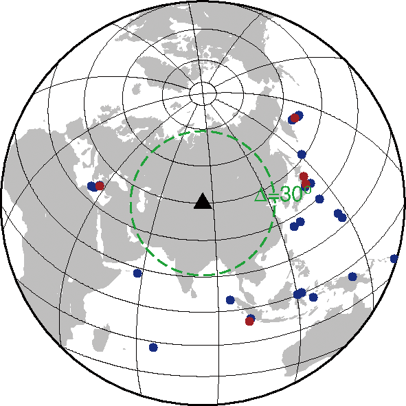
图2 远震事件分布图 黑色三角—台站位置;蓝色实心圆—31个远震事件;红色实心圆—5个后续用于成像计算的远震事件。
Fig.2 Azimuth-distance distribution of teleseismic events (circles)
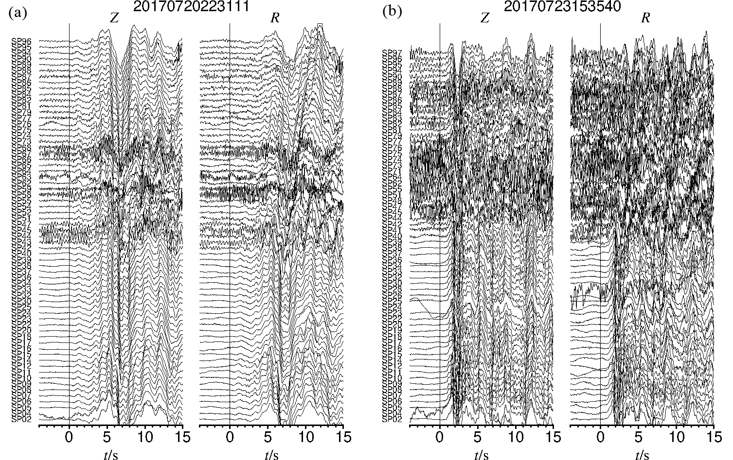
图3 P波初至(图中零时刻)对齐后的2个远震事件(“20170720223111”和“20170723153540”)的沿测线AA'(图1b)上所有台站记录的垂向(Z)和径向(R)分量波形数据示例
Fig.3 Teleseismic waveforms of vertical (Z) and radial (R) components for 2 earthquakes (“20170720223111” and “20170723153540”) aligned with the first P arrival with stations along survey line AA' (see Fig.1b for AA' location)
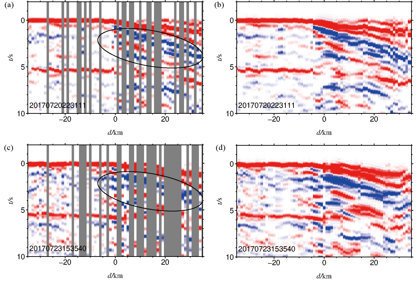
图4 图3对应的两个远震事件接收函数插值前(a,c)和插值后(b,d)结果图 图中椭圆形黑色实线圈定区域中包含低速盆地产生的多次波。
Fig.4 (a, c) RFs and (b, d) interpolated RFs of the two teleseismic events in Fig.3
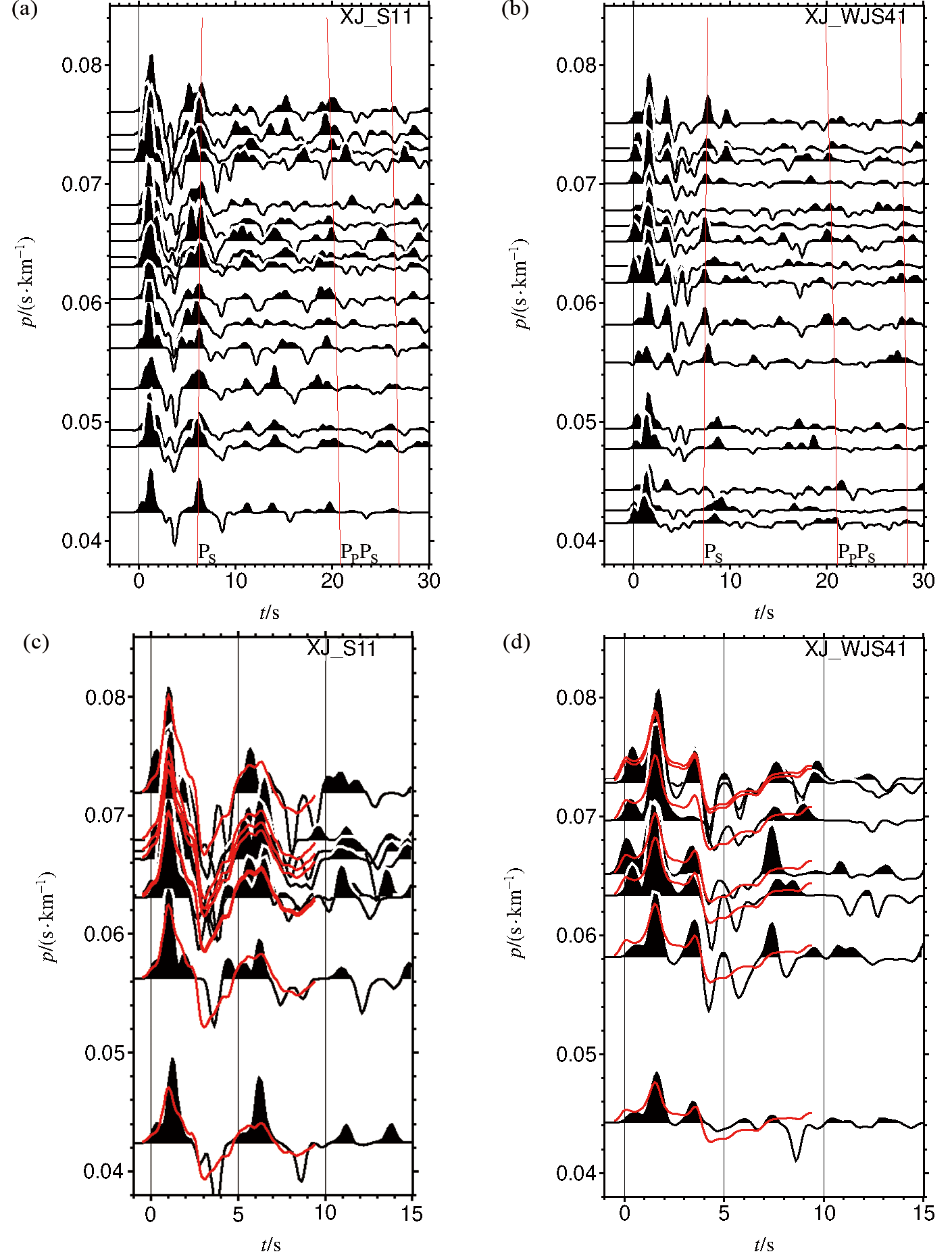
图5 NA反演用到的2个台站的接收函数波形。(a,b)台站XJ_S11和XJ_WJS41原始接收函数波形;(c,d)NA反演得到的台站XJ_S11和XJ_WJS4接接收函数波形拟合结果 图(c,d)中红色波形是由NA反演速度模型计算的理论接收函数波形。
Fig.5 Receiver functions recorded for XJ_S11 and XJ_WJS41 used in NA inversion. (a, b) RFs. (c, d) Receive function waveform fitting results.
| Station | Thickness/ km | vS1/ (km·s-1) | vS2/ (km·s-1) | κ/ (vP·vS) |
|---|---|---|---|---|
| XJ_S11 | 1.3 | 0.2 | 1.8 | 2.33 |
| XJ_WJS41 | 3.0 | 0.5 | 2.1 | 2.44 |
表1 台站XJ_S11和XJ_WJS41的接收函数用邻域反演得到的结果
Table 1 Receiver function inversion results for XJ_S11 and XJ_WJS41 using neighborhood algorithm (NA)
| Station | Thickness/ km | vS1/ (km·s-1) | vS2/ (km·s-1) | κ/ (vP·vS) |
|---|---|---|---|---|
| XJ_S11 | 1.3 | 0.2 | 1.8 | 2.33 |
| XJ_WJS41 | 3.0 | 0.5 | 2.1 | 2.44 |
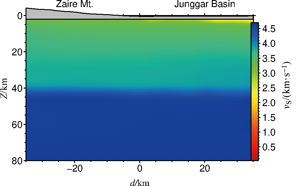
图6 二维S波背景速度模型
Fig.6 A 2-D S-wave velocity background model
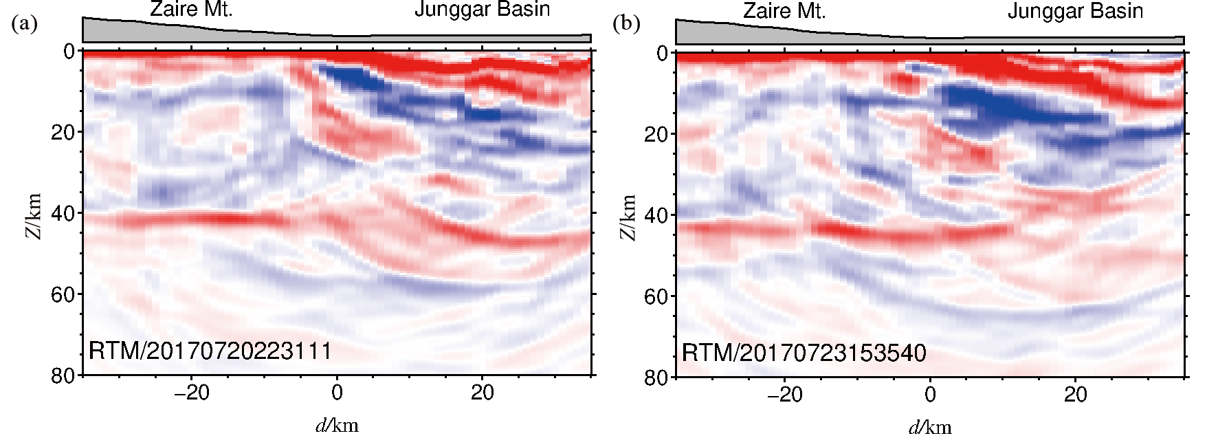
图7 图3中两个远震事件利用RF-RTM成像结果
Fig.7 RF-RTM imaging results for the two teleseismic events in Fig.3
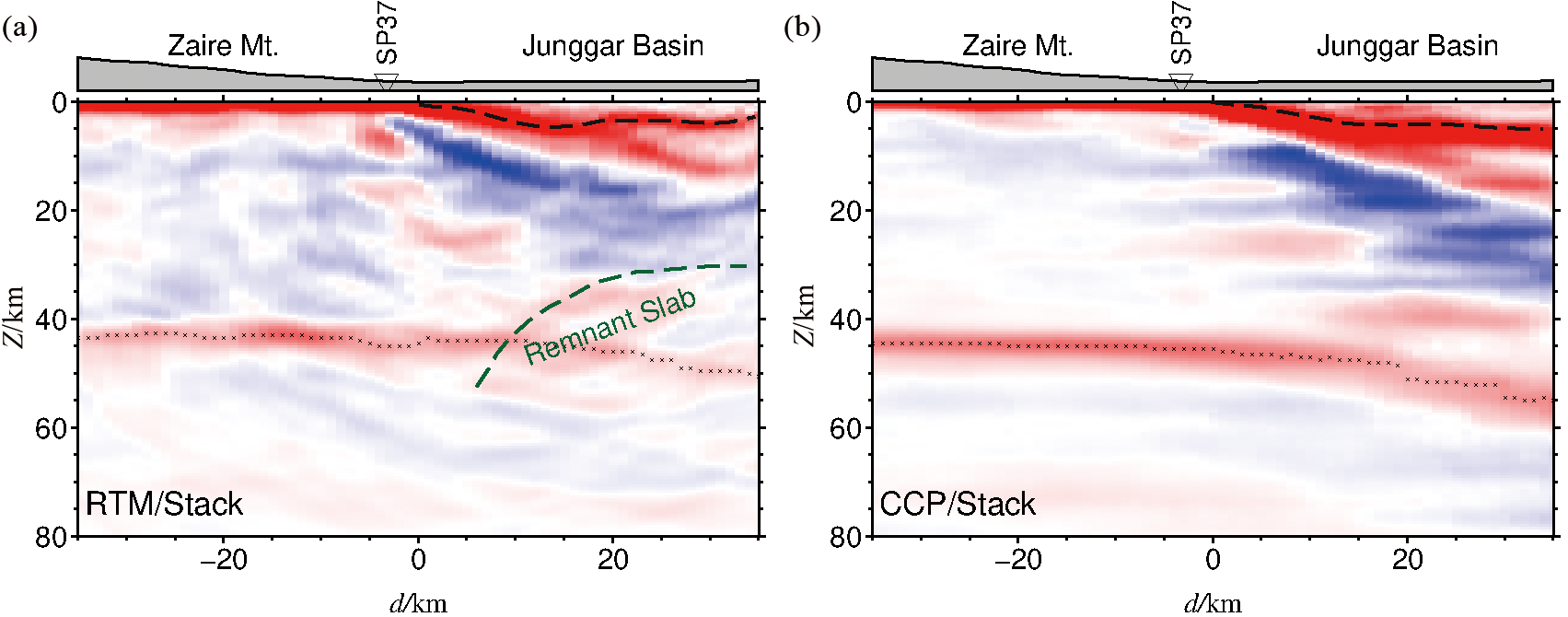
图8 成像结果图。(a)RF-RTM叠加成像结果和(b)CCP叠加成像结果 图中黑色×线代表Moho界面位置,黑色虚线代表准噶尔盆地基底界面位置。
Fig.8 The imaging results. (a) RF-RTM and (b) CCP stacking results.
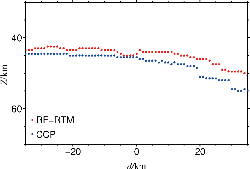
图9 RF-RTM方法和CCP方法成像结果在Moho界面处的离散图 红色实心圆—RF-RTM得到的Moho界面;蓝色实心圆—CCP得到的Moho界面。
Fig.9 Moho location from RF-RTM and CCP stacking imaging
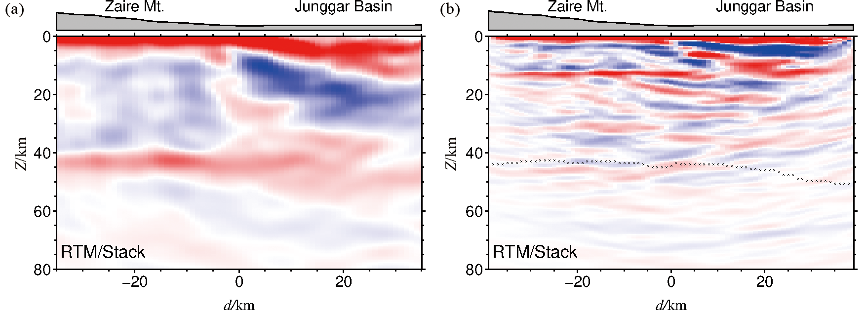
图10 影响因素分析图。(a)利用1 Hz高斯滤波的接收函数利用RF-RTM方法成像的结果;(b) 利用PPPS震相的RF-RTM成像结果 黑色×线为利用PS震相的RF-RTM的Moho位置。
Fig.10 Analysis diagram of influencing factors. (a) RF-RTM stacking images with low-pass filtered RFs using a 1 Hz Gaussian filter. (b) RF-RTM stacking images using PpPs phases. Black cross represents Moho discontinuity location.
| [1] |
FENG Y, COLEMAN R G, TILTON G, et al. Tectonic evolution of the West Junggar region, Xinjiang, China[J]. Tectonics, 1989, 8 (4): 729-752.
DOI URL |
| [2] |
WINDLEY B F, ALEXEIEV D, XIAO W, et al. Tectonic models for accretion of the central Asian Orogenic Belt[J]. Journal of the Geological Society, 2007, 164 (1): 31-47.
DOI URL |
| [3] |
XIAO W J, WINDLEY B F, YUAN C, et al. Paleozoic multiple subduction-accretion processes of the southern Altaids[J]. American Journal of Science, 2009, 309 (3): 221-270.
DOI URL |
| [4] |
ZHANG J E, XIAO W J, HAN C M, et al. A Devonian to Carboniferous intra-oceanic subduction system in western Junggar, NW China[J]. Lithos, 2011, 125(1/2): 592-606.
DOI URL |
| [5] |
KRUK N N, RUDNEV S N, VLADIMIROV A G, et al. Early-Middle Paleozoic granitoids in Gorny Altai, Russia: implications or continental crust history and magma sources[J]. Journal of Asian Earth Sciences, 2011, 42(5): 928-948.
DOI URL |
| [6] |
KRONER A, KOVACH V, BELOUSOVA E, et al. Reassessment of continental growth during the accretionary history of the central Asian Orogenic Belt[J]. Gondwana Research, 2014, 25(1): 103-125.
DOI URL |
| [7] |
LI D, HE D, SANTOSH M, et al. Tectonic framework of the northern Junggar Basin Part II: the island arc basin system of the western Luliang Uplift and its link with the West Junggar terrane[J]. Gondwana Research, 2015, 27(3): 1110-1130.
DOI URL |
| [8] |
CHEN Y, WU T, GAN L, et al. Provenance of the early to mid-Paleozoic sediments in the northern Alxa area: implications for tectonic evolution of the southwestern central Asian Orogenic Belt[J]. Gondwana Research, 2019, 67: 115-130.
DOI URL |
| [9] |
XIAO W J, ZHANG L C, QIN K Z, et al. Paleozoic accretionary and collisional tectonics of the eastern Tianshan (China): implication for the continental growth of central Asia[J]. American Journal of Science, 2004, 304(4): 370-395.
DOI URL |
| [10] | BUCKMAN S, AITCHISON J. Tectonic evolution of Paleozoic terranes in West Junggar, Xinjiang, NW China[M]// Aspects of the tectonic evolution of China. London: Geological Society, 2004, 226(1): 101-129. |
| [11] |
COLEMAN R G. Continental growth of Northwest China[J]. Tectonics, 1989, 8(3): 621-635.
DOI URL |
| [12] |
王小军, 宋永, 郑孟林, 等. 准噶尔西部陆内盆地构造演化与油气聚集[J]. 地学前缘, 2022, 29(6): 188-205.
DOI |
| [13] |
VASYUKOVA E A, LZOKH A E, BORISENKO A S, et al. Early Mesozoic lamprophyres in Gorny Altai: petrology and age boundaries[J]. Russian Geology and Geophysics, 2011, 52(12): 1574-1591.
DOI URL |
| [14] |
CHEN B, ARAKAWA Y. Elemental and Nd-Sr isotopic geochemistry of granitoids from the west Junggar foldbelt (NW China), with implications for Phanerozoic continental growth[J]. Geochimica et Cosmochimica Acta, 2005, 69(5): 1307-1320.
DOI URL |
| [15] | XU X, HE G, LI H, et al. Basic characteristics of the Karamay ophiolitic mélange, Xinjiang, and its zircon SHRIMP dating[J]. Geology in China, 2006, 33(3): 470-475. |
| [16] |
KRONER A, KOVACH V, BELOUSOVA E, et al. Reassessment of continental growth during the accretionary history of the central Asian Orogenic Belt[J]. Gondwana Research, 2014, 25(1): 103-125.
DOI URL |
| [17] | 马绪宣. 中国中天山前寒武纪构造属性及古生代构造演化[D]. 南京: 南京大学, 2014. |
| [18] |
CHEN Y, WU T, GAN L, et al. Provenance of the early to mid-Paleozoic sediments in the northern Alxa area: implications for tectonic evolution of the southwestern central Asian Orogenic Belt[J]. Gondwana Research, 2019, 67: 115-130.
DOI URL |
| [19] | HE G Q, LIU J B, ZHANG Y Q, et al. Karamay ophiolitic mélange formed during early Paleozoic in West Junggar Basin[J]. Acta Petrologica Sinica, 2007, 23(7): 1573-1576. |
| [20] |
杨高学, 李永军. 西准噶尔洋中海山及其俯冲带处地质效应[J]. 地学前缘, 2015, 22(6): 233-240.
DOI |
| [21] |
SENGÖR A M C, NATAL’IN B A, BURTMAN V S. Evolution of the Altaids tectonic collage and Palaeozoic crustal growth in Eurasia[J]. Nature, 1993, 364(6435): 299-307.
DOI |
| [22] |
JAHN B M, WU F, CHEN B. Massive granitoid generation in central Asian: Nd isotope evidence and implication for continental growth in the Phanerozoic[J]. Episodes, 2000, 23(2): 82-92.
DOI URL |
| [23] |
LI D, HE D, FAN C. Geochronology and Sr-Nd-Hf isotopic composition of the granites, enclaves, and dikes in the Karamay area, NW China: insights into late Carboniferous crustal growth of west Junggar[J]. Geoscience Frontiers, 2015, 6(2): 153-173.
DOI URL |
| [24] | ZHANG C, HUANG X. The ages and tectonic settings of ophiolites in West Junggar, Xinjiang[J]. Geological Review, 1992, 38(6): 509-524. |
| [25] | SU Y, TANG H, HOU G, et al. Geochemistry of aluminous A-type granites along Darabut tectonic belt in West Junggar, Xinjiang[J]. Geochimica, 2006, 35(1): 55-67. |
| [26] |
XIAO W, HAN C, YUAN C, et al. Middle Cambrian to Permian subduction-related accretionary orogenesis of Northern Xinjiang, NW China: implications for the tectonic evolution of central Asia[J]. Journal of Asian Earth Sciences, 2008, 32(2/3/4): 102-117.
DOI URL |
| [27] | 李锦轶, 何国琦, 徐新, 等. 新疆北部及邻区地壳构造格架及其形成过程的初步探讨[J]. 地质学报, 2006, 80(1): 148-168. |
| [28] |
YANG G, LI Y, GU P, et al. Geochronological and geochemical study of the Darbut Ophiolitic Complex in the West Junggar (NW China): implications for petrogenesis and tectonic evolution[J]. Gondwana Research, 2012, 21(4): 1037-1049.
DOI URL |
| [29] |
XU Y X, YANG B, ZHANG S, et al. Magnetotelluric imaging of a fossil paleozoic intraoceanic subduction zone in western Junggar, NW China[J]. Journal of Geophysical Research: Solid Earth, 2016, 121(6): 4103-4117.
DOI URL |
| [30] |
GENG H, SUN M, YUAN C, et al. Geochemical, Sr-Nd and zircon U-Pb-Hf isotopic studies of Late Carboniferous magmatism in the West Junggar, Xinjiang: implications for ridge subduction?[J]. Chemical Geology, 2009, 266(3/4): 364-389.
DOI URL |
| [31] |
ALLEN M, VINCENT S. Fault reactivation in the Junggar region, Northwest China: the role of basement structures during Mesozoic-Cenozoic compression[J]. Journal of the Geological Society, 1997, 154(1): 151-155.
DOI URL |
| [32] |
ZHANG S, XU Y X, JIANG L, et al. Electrical structures in the northwest margin of the Junggar Basin: implications for its late Paleozoic geodynamics[J]. Tectonophysics, 2017, 717: 473-483.
DOI URL |
| [33] |
LIU Y, JUNGE A, YANG B, et al. Electrically anisotropic crust from three dimensional magnetotelluric modeling in the western Junggar, NW China[J]. Journal of Geophysical Research: Solid Earth, 2019, 124(9): 9474-9494.
DOI URL |
| [34] |
XU Y X, YANG B, ZHAN A, et al. Magnetotelluric imaging of a fossil oceanic plate in northwestern Xinjiang, China[J]. Geology, 2020, 48 (4): 385-389.
DOI URL |
| [35] |
WU S C, HUANG R, XU Y X, et al. Seismological evidence for a remnant oceanic slab in the western Junggar, Northwest China[J]. Journal of Geophysical Research: Solid Earth, 2018, 123(5): 4157-4170.
DOI URL |
| [36] | HUA Y, XU Y X, ZHAO D, et al. Upper mantle tomography of the western Junggar: implication for its geodynamic evolution[J]. Physics of the Earth and Planetary, 2020, 299. DOI: 10.1016/j.pepi.2019.106405. |
| [37] | 许顺芳, 陈超, 杜劲松, 等. 西准噶尔及邻区的岩石圈密度结构特征及其构造意义[J]. 地球科学: 中国地质大学学报, 2015, 40(9): 1556-1565. |
| [38] |
ZHAO J, DENG G, XU Q, et al. Basement structure and properties of the southern Junggar Basin[J]. Journal of Geodynamics, 2018, 121: 26-35.
DOI URL |
| [39] |
ZHANG A, AFONSO J, XU Y, et al. The deep lithospheric structure of the Junggar terrane, NW China: implications for its origin and tectonic evolution[J]. Journal of Geophysical Research: Solid Earth, 2019, 124(11): 11615-11638.
DOI URL |
| [40] | JIANG X H, ZHU L P, HU S Q, et al. 3-D reverse time migration of teleseismic receiver functions using the phase shift plus interpolation method[J]. Geophysical Journal International, 2019, 271(2): 1047-1057. |
| [41] |
LIGORRIA J P, AMMON C J. Iterative deconvolution and receiver-function estimation[J]. Bulletin of the Seismological Society of America, 1999, 89(5): 1395-1400.
DOI URL |
| [42] |
HU S Q, JIANG X H, ZHU L P, et al. Wavefiled reconstruction of teleseismic receiver function with the stretching-and-squeezing interpolation method[J]. Seismological Research Letters, 2019, 90 (2A): 716-726.
DOI URL |
| [43] | 姜小欢. 远震接收函数三维逆时偏移方法研究及其应用[D]. 武汉: 中国地质大学(武汉), 2019. |
| [44] | WHITMORE N D. Iterative depth migration by backward time propagation[C]. The 53rd SEG Meeting, Las Vegas. 1983: 382-385. |
| [45] | CLAERBOUT J F. Toward a unified theory of reflector mapping[J]. Geophysics, 1971, 36(3): 461-481. |
| [46] | BIONDI B, SHAN G. Prestack imaging of overturned reflections by reverse time migration[C]// 72nd annual international meeting, SEG, expanded abstracts. 2002: 1284-1287. |
| [47] |
GAZDAG J, SGUAZZERO P. Migration of seismic data by phase shift plus interpolation[J]. Geophysics, 1984, 49 (2): 124-131.
DOI URL |
| [48] |
WHITMORE N D, LINES L R. Vertical seismic profiling depth migration of a salt dome flank[J]. Geophysics, 1986, 51(5): 1087.
DOI URL |
| [49] |
WU S C, YANG Y, XU Y, et al. A fossil oceanic lithosphere preserved inside a continent[J]. Geology, 2023, 51(2): 204-208.
DOI URL |
| [50] |
SAMIBRIDGE M. Geophysical inversion with a neighbourhood algorithm: I.Searching a parameter space[J]. Geophysical Journal International, 1999, 138(2): 479-494.
DOI URL |
| [51] |
SAMIBRIDGE M. Geophysical inversion with a neighbourhood algorithm: II.Appraising the ensemble[J]. Geophysical Journal International, 1999, 138(3): 727-746.
DOI URL |
| [52] |
ZHU L P. Crustal structure across the San Andreas Fault, southern California from teleseismic converted waves[J]. Earth and Planetary Science Letters, 2000, 179(1): 183-190.
DOI URL |
| [53] |
MA C, XIAO W, WINDLEY B F, et al. Tracing a subducted ridge-transform system in a late Carboniferous accretionary prism of the southern Altaids: orthogonal sanukitoid dyke swarms in western Junggar, NW China[J]. Lithos, 2012, 140/141: 152-165.
DOI URL |
| [54] |
YIN J, LONG X, YUAN C, et al. A late Carboniferous-early Permian slab window in the West Junggar of NW China: geochronological and geochemical evidence from mafic to intermediate dikes[J]. Lithos, 2013, 175/176: 146-162.
DOI URL |
| [55] |
ZHANG J, XIAO W, HAN C, et al. Kinematics and age constraints of deformation in a late Carboniferous accretionary complex in western Junggar, NW China[J]. Gondwana Research, 2011, 19(4): 958-974.
DOI URL |
| [1] | 支倩, 任蕊, 段丰浩, 黄家瑄, 朱钊, 张新远, 李永军. 西准噶尔南部晚石炭世中-酸性火山岩成因机制及其对准噶尔洋闭合时限的约束[J]. 地学前缘, 2024, 31(3): 40-58. |
| [2] | 蔡蔚, 卢占武, 黄荣, 李文辉, 罗银河, 王光文, 穆青, 程永志, 陈司, 王冠, 陈子龙. 基于短周期密集台阵接收函数揭示的藏南错那洞穹窿地壳结构[J]. 地学前缘, 2024, 31(1): 170-180. |
| [3] | 程永志, 高锐, 卢占武, 李文辉, 王光文, 陈司, 吴国炜, 蔡玉国. 青藏高原东北缘祁连造山带东段深部结构及其动力学过程[J]. 地学前缘, 2023, 30(5): 314-333. |
| [4] | 穆青, 黄荣, 严加永, 卢占武, 罗银河, 张永谦, 姜小欢, 文宏斌, 魏鹏龙, 周万里. 利用接收函数H-κ-c叠加方法约束武陵山重力梯度带地壳结构[J]. 地学前缘, 2023, 30(5): 369-383. |
| [5] | 李强, 吴建平. 中国大陆东南缘地壳厚度与泊松比及其构造意义[J]. 地学前缘, 2023, 30(5): 408-419. |
| [6] | 仝霄飞, 徐啸, 郭晓玉, 李春森, 向波, 余嘉豪, 罗旭聪, 袁梓昭, 林燕琪, 时宏城. 接收函数成像揭示东昆仑断裂带及其周缘地壳结构[J]. 地学前缘, 2023, 30(4): 270-282. |
| [7] | 徐啸, 余嘉豪, 向波, 郭晓玉, 李春森, 罗旭聪, 仝霄飞, 袁梓昭, 林燕琪, 时宏城. 拉萨地体东南缘地壳深部结构[J]. 地学前缘, 2023, 30(3): 221-232. |
| [8] | 李春森, 徐啸, 向波, 郭晓玉, 吴优, 吴佳杰, 罗旭聪, 余嘉豪, 仝霄飞, 袁梓昭, 林燕琪. 北喜马拉雅构造带东部Moho形态研究:以接收函数3DCCP方法为例[J]. 地学前缘, 2023, 30(2): 57-67. |
| [9] | 吴佳杰, 徐啸, 郭晓玉, 卢占武, 吴优, 向波, 于洋, 李春森, 余嘉豪, 仝霄飞, 罗旭聪. 喜马拉雅造山带东段错那裂谷的地壳结构[J]. 地学前缘, 2022, 29(4): 221-230. |
| [10] | 周鹏哲, 高锐, 叶卓. 祁连山中部地壳各向异性研究:来自远震接收函数的证据[J]. 地学前缘, 2022, 29(4): 265-277. |
| [11] | 卢占武, 高锐, Simon KLEMPERER, 王海燕, 董树文, 李文辉, 李洪强. 喜马拉雅西部雅鲁藏布江缝合带地壳尺度的构造叠置[J]. 地学前缘, 2022, 29(2): 210-217. |
| [12] | 徐盛林, 丁伟翠, 陈宣华, 李廷栋, 韩乐乐, 刘勇, 马飞宙, 王叶. 西准噶尔晚古生代地壳组成与生长:来自Sr-Nd-Pb同位素填图的证据[J]. 地学前缘, 2022, 29(2): 261-280. |
| [13] | Valentina V. MORDVINOVA, Maria A. KHRITOVA, Elena A. KOBELEVA, Mikhail M. KOBELEV, Evgeniy Kh. TURUTANOV, Victor S. KANAYKIN. 远震数据显示贝加尔裂谷带北穆伊斯克(Severomuysk)段地壳和上地幔的精细结构[J]. 地学前缘, 2022, 29(2): 378-392. |
| [14] | 梁锋,高磊,王志辉,李海龙,刘凯,王涛,李晓昭. 利用背景噪声层析成像研究济南浅层横波速度结构[J]. 地学前缘, 2019, 26(3): 129-139. |
| [15] | 杨高学,李永军,佟丽莉,李甘雨,吴乐. 西准噶尔海山俯冲的地质效应:来自泥盆纪—石炭纪火山岩地球化学证据[J]. 地学前缘, 2017, 24(6): 60-67. |
| 阅读次数 | ||||||
|
全文 |
|
|||||
|
摘要 |
|
|||||