地学前缘 ›› 2023, Vol. 30 ›› Issue (5): 408-419.DOI: 10.13745/j.esf.sf.2022.9.8
李强1,2( ), 吴建平1,*()
收稿日期:2022-06-20
修回日期:2022-09-01
出版日期:2023-09-25
发布日期:2023-10-20
通信作者:
*吴建平(1964—),男,博士,研究员,主要从事地球深部构造研究工作。E-mail: wjpwu@cea-igp.ac.cn
作者简介:李 强(1985—),男,博士研究生,工程师,主要从事地震学研究工作。E-mail: liaobeitl@163.com
基金资助:
LI Qiang1,2(), WU Jianping1,*()
Received:2022-06-20
Revised:2022-09-01
Online:2023-09-25
Published:2023-10-20
摘要:
自中生代以来,中国大陆东南缘经历了复杂的构造演化过程,尤其是晚中生代发生了剧烈的岩浆活动。研究该区域下方的地壳厚度和泊松比,有助于增进对壳幔相互作用及其动力学过程的理解。本文利用中国大陆东南缘90个固定地震台站(包括88个福建台站和2个中国台湾台站)的远震数据,使用P波接收函数H-κ叠加方法,获得了台站下方附近的地壳厚度和平均泊松比,并结合前人的流动观测结果,给出了高分辨率的地壳厚度和泊松比分布图像。结果表明:研究区地壳厚度为28.0~34.1 km,平均厚度31.0 km;地壳泊松比变化范围为0.22~0.29,平均值为0.26。区内莫霍面变化较为平缓,整体表现为由内陆向沿海减薄,局部地区存在一定的起伏,部分断裂带两侧差异显著。中国大陆东南缘的沿海地区不属于陆壳和洋壳的过渡区,其属性主要为减薄型的陆壳区。福安—南靖断裂带为该区域内一条极为重要的断裂带,其东侧沿海地区的泊松比与地壳厚度呈正相关,而西侧为负相关,东侧地区泊松比整体上高于西侧的内陆地区,可能与沿海地区晚中生代岩浆底侵作用及壳内低速薄层发育有关。
中图分类号:
李强, 吴建平. 中国大陆东南缘地壳厚度与泊松比及其构造意义[J]. 地学前缘, 2023, 30(5): 408-419.
LI Qiang, WU Jianping. Crustal thickness and Poisson’s ratio beneath the continental margin of southeastern China and the tectonic implications[J]. Earth Science Frontiers, 2023, 30(5): 408-419.

图1 观测台站与地震事件分布 F1 —邵武—河源断裂带;F2—政和—大埔断裂带;F3—福安—南靖断裂带;F4—长乐—诏安断裂带;F5—闽江断裂带;F6—南日岛断裂;F7—湄洲湾断裂;F8—永安—晋江断裂带;F9—九龙江断裂;F10—上杭—云霄断裂带。
Fig.1 Regional maps showing the location and distribution of seismic stations and teleseismic events relevant to this study

图2 YDXS台和ZPLA台径向接收函数 左图接收函数按后方位角排列,右图黑色三角和红点菱形分别表示远震事件对应的震中距和后方位角。
Fig.2 Radial receiver functions at stations YDXS and ZPLA

图3 YDXS台和ZPLA台接收函数H-κ叠加结果
Fig.3 H-κ stacking results for stations YDXS and ZPLA
| 台站代码 | 经度/(°) | 纬度/(°) | H/km | κ | σ | 台站代码 | 经度/(°) | 纬度/(°) | H/km | κ | σ |
|---|---|---|---|---|---|---|---|---|---|---|---|
| AXCK | 117.87 | 25.23 | 31.4±0.8 | 1.73±0.03 | 0.25 | PTDT | 119.27 | 25.26 | 29.2±0.7 | 1.75±0.03 | 0.26 |
| AXCN | 118.21 | 25.08 | 30.3±0.7 | 1.74±0.03 | 0.25 | PTLC | 119.01 | 25.45 | 29.2±0.7 | 1.78±0.03 | 0.27 |
| AXDP | 117.97 | 24.99 | 30.5±0.8 | 1.76±0.03 | 0.26 | PTMZ | 119.12 | 25.04 | 28.5±0.7 | 1.73±0.03 | 0.25 |
| CTCX | 117.74 | 24.70 | 29.8±07 | 1.78±0.03 | 0.27 | PTNR | 119.47 | 25.22 | 29.3±0.7 | 1.75±0.03 | 0.26 |
| CTTZ | 116.36 | 25.84 | 31.9±0.6 | 1.75±0.03 | 0.26 | PTTC | 119.78 | 25.50 | 29.5±0.6 | 1.78±0.03 | 0.27 |
| DHTT | 118.13 | 25.80 | 32.1±0.7 | 1.70±0.02 | 0.24 | QGQH | 118.90 | 25.15 | 29.0±0.8 | 1.74±0.03 | 0.25 |
| DHTZ | 118.22 | 25.51 | 31.2±0.7 | 1.76±0.03 | 0.26 | QZH | 118.56 | 24.94 | 28.7±0.5 | 1.76±0.02 | 0.26 |
| DSXP | 117.43 | 23.71 | 28.1±0.8 | 1.74±0.03 | 0.25 | SCLX | 117.98 | 26.97 | 30.7±0.7 | 1.73±0.02 | 0.25 |
| DTJX | 117.84 | 25.68 | 31.3±0.9 | 1.73±0.03 | 0.25 | SHLC | 116.45 | 25.03 | 31.4±0.6 | 1.72±0.02 | 0.24 |
| FACY | 119.68 | 27.10 | 31.5±1.0 | 1.82±0.03 | 0.28 | SHLX | 116.63 | 24.93 | 30.8±0.6 | 1.75±0.03 | 0.26 |
| FDGL | 120.24 | 27.37 | 31.4±0.6 | 1.76±0.02 | 0.26 | SHXD | 116.44 | 24.82 | 30.9±0.7 | 1.75±0.03 | 0.26 |
| FDQY | 120.26 | 27.12 | 29.6±0.7 | 1.83±0.03 | 0.29 | SNQY | 119.48 | 27.40 | 32.3±1.0 | 1.74±0.03 | 0.25 |
| FQDZ | 119.29 | 25.70 | 29.9±0.8 | 1.78±0.02 | 0.27 | SWDT | 117.48 | 27.33 | 31.7±0.7 | 1.69±0.02 | 0.23 |
| FZCM | 119.37 | 26.01 | 31.0±0.6 | 1.82±0.02 | 0.28 | SXFK | 117.65 | 26.40 | 31.5±0.8 | 1.72±0.02 | 0.25 |
| FZLQ | 119.58 | 26.10 | 32.1±0.8 | 1.75±0.02 | 0.26 | SXJX | 118.85 | 27.61 | 32.0±0.6 | 1.77±0.02 | 0.27 |
| FZRX | 119.28 | 26.37 | 31.1±0.7 | 1.77±0.03 | 0.27 | TNSC | 117.18 | 26.91 | 32.5±0.8 | 1.68±0.02 | 0.23 |
| GTSK | 118.73 | 26.37 | 30.0±0.5 | 1.79±0.02 | 0.27 | WPPC | 116.11 | 25.07 | 31.3±0.9 | 1.74±0.03 | 0.25 |
| GTYT | 118.74 | 26.59 | 31.7±0.7 | 1.74±0.02 | 0.25 | WPXD | 116.21 | 25.43 | 31.7±0.7 | 1.73±0.03 | 0.25 |
| GZLF | 117.31 | 27.51 | 31.2±0.9 | 1.77±0.03 | 0.27 | WYXF | 118.01 | 27.75 | 32.7±0.9 | 1.75±0.03 | 0.26 |
| HAHF | 117.52 | 25.01 | 31.8±0.8 | 1.70±0.03 | 0.24 | XMJM | 117.98 | 24.65 | 29.3±0.7 | 1.79±0.03 | 0.27 |
| HAJF | 118.96 | 24.98 | 28.0±0.7 | 1.75±0.03 | 0.26 | XMSM | 118.08 | 24.45 | 29.5±0.7 | 1.74±0.03 | 0.25 |
| JJJJ | 118.59 | 24.55 | 28.5±0.5 | 1.75±0.02 | 0.26 | XPSS | 120.19 | 26.93 | 30.2±0.6 | 1.79±0.02 | 0.27 |
| JLNK | 117.49 | 26.58 | 31.3±0.8 | 1.72±0.02 | 0.24 | XYSC | 118.74 | 25.61 | 33.4±0.9 | 1.69±0.03 | 0.23 |
| JNSX | 116.92 | 26.81 | 33.3±0.9 | 1.69±0.02 | 0.23 | XYXY | 118.58 | 25.58 | 31.6±0.9 | 1.79±0.03 | 0.27 |
| JOJA | 118.34 | 27.06 | 30.9±0.6 | 1.73±0.02 | 0.25 | YAHN | 117.71 | 25.97 | 31.8±0.7 | 1.71±0.03 | 0.24 |
| LCGT | 116.89 | 25.73 | 32.0±0.8 | 1.72±0.02 | 0.24 | YAXT | 117.13 | 25.72 | 31.5±0.5 | 1.73±0.02 | 0.25 |
| LCJX | 116.73 | 25.49 | 32.3±0.6 | 1.72±0.02 | 0.24 | YAYX | 117.39 | 25.99 | 31.9±0.6 | 1.73±0.02 | 0.25 |
| LJTL | 119.92 | 26.35 | 30.8±0.7 | 1.77±0.03 | 0.27 | YCSG | 118.23 | 25.34 | 30.9±0.9 | 1.72±0.03 | 0.25 |
| LYJJ | 119.77 | 26.55 | 30.4±0.8 | 1.81±0.03 | 0.28 | YDFS | 116.94 | 24.76 | 32.4±0.8 | 1.72±0.03 | 0.24 |
| LYXP | 117.02 | 25.13 | 31.7±0.7 | 1.75±0.03 | 0.26 | YDXS | 116.63 | 24.70 | 31.4±0.5 | 1.70±0.02 | 0.23 |
| MHZQ | 119.03 | 26.10 | 31.8±0.9 | 1.76±0.03 | 0.26 | YTFQ | 118.87 | 25.82 | 32.5±0.6 | 1.73±0.03 | 0.25 |
| MQDQ | 118.91 | 26.38 | 32.0±0.7 | 1.76±0.02 | 0.26 | YTGL | 119.09 | 25.84 | 31.8±0.8 | 1.79±0.03 | 0.27 |
| MQXJ | 118.73 | 26.32 | 31.1±0.9 | 1.74±0.03 | 0.25 | YTGY | 118.47 | 25.84 | 33.6±0.6 | 1.75±0.02 | 0.26 |
| MXXF | 117.19 | 26.35 | 32.3±0.7 | 1.74±0.03 | 0.25 | YXBM | 118.11 | 26.04 | 32.6±0.7 | 1.67±0.02 | 0.22 |
| NDZW | 119.56 | 26.68 | 31.6±0.6 | 1.77±0.02 | 0.27 | YXHT | 117.40 | 23.98 | 28.3±0.6 | 1.75±0.03 | 0.26 |
| NHCN | 116.67 | 26.22 | 31.4±0.9 | 1.74±0.03 | 0.25 | ZAQD | 117.19 | 23.67 | 28.5±0.6 | 1.75±0.02 | 0.26 |
| NJJS | 117.33 | 24.79 | 31.3±0.8 | 1.77±0.03 | 0.27 | ZHNZ | 118.86 | 27.36 | 32.2±0.7 | 1.74±0.02 | 0.25 |
| NPDK | 118.19 | 26.62 | 31.0±0.7 | 1.69±0.02 | 0.23 | ZPCH | 117.87 | 24.14 | 28.3±0.6 | 1.79±0.03 | 0.27 |
| NPZH | 118.47 | 26.37 | 30.5±0.6 | 1.75±0.02 | 0.26 | ZPGN | 117.40 | 25.26 | 30.9±0.8 | 1.79±0.03 | 0.27 |
| PCGL | 118.55 | 28.23 | 34.1±0.7 | 1.74±0.02 | 0.25 | ZPLA | 117.74 | 23.93 | 28.2±0.6 | 1.76±0.02 | 0.26 |
| PCNP | 118.52 | 27.91 | 32.6±0.8 | 1.76±0.02 | 0.26 | ZPXH | 117.66 | 25.41 | 31.7±0.7 | 1.74±0.02 | 0.25 |
| PHJF | 117.05 | 24.23 | 30.6±0.9 | 1.73±0.03 | 0.25 | ZPYF | 117.34 | 25.11 | 31.3±0.8 | 1.77±0.03 | 0.27 |
| PHSG | 117.34 | 24.40 | 30.2±0.7 | 1.76±0.02 | 0.26 | ZZJH | 117.63 | 24.47 | 29.5±0.6 | 1.77±0.02 | 0.27 |
| PNTK | 118.97 | 26.98 | 32.0±0.7 | 1.75±0.02 | 0.26 | KMNB | 118.39 | 24.46 | 29.4±0.5 | 1.74±0.02 | 0.25 |
| PTAQ | 119.85 | 25.46 | 29.4±0.8 | 1.77±0.03 | 0.27 | MATB | 119.93 | 26.14 | 32.4±0.9 | 1.74±0.03 | 0.25 |
表1 台站下方地壳厚度H、波速比κ及泊松比σ
Table 1 Calculation results on crustal thickness (H), velocity ratio (κ) and Poisson’s ratio (σ) for seismic stations
| 台站代码 | 经度/(°) | 纬度/(°) | H/km | κ | σ | 台站代码 | 经度/(°) | 纬度/(°) | H/km | κ | σ |
|---|---|---|---|---|---|---|---|---|---|---|---|
| AXCK | 117.87 | 25.23 | 31.4±0.8 | 1.73±0.03 | 0.25 | PTDT | 119.27 | 25.26 | 29.2±0.7 | 1.75±0.03 | 0.26 |
| AXCN | 118.21 | 25.08 | 30.3±0.7 | 1.74±0.03 | 0.25 | PTLC | 119.01 | 25.45 | 29.2±0.7 | 1.78±0.03 | 0.27 |
| AXDP | 117.97 | 24.99 | 30.5±0.8 | 1.76±0.03 | 0.26 | PTMZ | 119.12 | 25.04 | 28.5±0.7 | 1.73±0.03 | 0.25 |
| CTCX | 117.74 | 24.70 | 29.8±07 | 1.78±0.03 | 0.27 | PTNR | 119.47 | 25.22 | 29.3±0.7 | 1.75±0.03 | 0.26 |
| CTTZ | 116.36 | 25.84 | 31.9±0.6 | 1.75±0.03 | 0.26 | PTTC | 119.78 | 25.50 | 29.5±0.6 | 1.78±0.03 | 0.27 |
| DHTT | 118.13 | 25.80 | 32.1±0.7 | 1.70±0.02 | 0.24 | QGQH | 118.90 | 25.15 | 29.0±0.8 | 1.74±0.03 | 0.25 |
| DHTZ | 118.22 | 25.51 | 31.2±0.7 | 1.76±0.03 | 0.26 | QZH | 118.56 | 24.94 | 28.7±0.5 | 1.76±0.02 | 0.26 |
| DSXP | 117.43 | 23.71 | 28.1±0.8 | 1.74±0.03 | 0.25 | SCLX | 117.98 | 26.97 | 30.7±0.7 | 1.73±0.02 | 0.25 |
| DTJX | 117.84 | 25.68 | 31.3±0.9 | 1.73±0.03 | 0.25 | SHLC | 116.45 | 25.03 | 31.4±0.6 | 1.72±0.02 | 0.24 |
| FACY | 119.68 | 27.10 | 31.5±1.0 | 1.82±0.03 | 0.28 | SHLX | 116.63 | 24.93 | 30.8±0.6 | 1.75±0.03 | 0.26 |
| FDGL | 120.24 | 27.37 | 31.4±0.6 | 1.76±0.02 | 0.26 | SHXD | 116.44 | 24.82 | 30.9±0.7 | 1.75±0.03 | 0.26 |
| FDQY | 120.26 | 27.12 | 29.6±0.7 | 1.83±0.03 | 0.29 | SNQY | 119.48 | 27.40 | 32.3±1.0 | 1.74±0.03 | 0.25 |
| FQDZ | 119.29 | 25.70 | 29.9±0.8 | 1.78±0.02 | 0.27 | SWDT | 117.48 | 27.33 | 31.7±0.7 | 1.69±0.02 | 0.23 |
| FZCM | 119.37 | 26.01 | 31.0±0.6 | 1.82±0.02 | 0.28 | SXFK | 117.65 | 26.40 | 31.5±0.8 | 1.72±0.02 | 0.25 |
| FZLQ | 119.58 | 26.10 | 32.1±0.8 | 1.75±0.02 | 0.26 | SXJX | 118.85 | 27.61 | 32.0±0.6 | 1.77±0.02 | 0.27 |
| FZRX | 119.28 | 26.37 | 31.1±0.7 | 1.77±0.03 | 0.27 | TNSC | 117.18 | 26.91 | 32.5±0.8 | 1.68±0.02 | 0.23 |
| GTSK | 118.73 | 26.37 | 30.0±0.5 | 1.79±0.02 | 0.27 | WPPC | 116.11 | 25.07 | 31.3±0.9 | 1.74±0.03 | 0.25 |
| GTYT | 118.74 | 26.59 | 31.7±0.7 | 1.74±0.02 | 0.25 | WPXD | 116.21 | 25.43 | 31.7±0.7 | 1.73±0.03 | 0.25 |
| GZLF | 117.31 | 27.51 | 31.2±0.9 | 1.77±0.03 | 0.27 | WYXF | 118.01 | 27.75 | 32.7±0.9 | 1.75±0.03 | 0.26 |
| HAHF | 117.52 | 25.01 | 31.8±0.8 | 1.70±0.03 | 0.24 | XMJM | 117.98 | 24.65 | 29.3±0.7 | 1.79±0.03 | 0.27 |
| HAJF | 118.96 | 24.98 | 28.0±0.7 | 1.75±0.03 | 0.26 | XMSM | 118.08 | 24.45 | 29.5±0.7 | 1.74±0.03 | 0.25 |
| JJJJ | 118.59 | 24.55 | 28.5±0.5 | 1.75±0.02 | 0.26 | XPSS | 120.19 | 26.93 | 30.2±0.6 | 1.79±0.02 | 0.27 |
| JLNK | 117.49 | 26.58 | 31.3±0.8 | 1.72±0.02 | 0.24 | XYSC | 118.74 | 25.61 | 33.4±0.9 | 1.69±0.03 | 0.23 |
| JNSX | 116.92 | 26.81 | 33.3±0.9 | 1.69±0.02 | 0.23 | XYXY | 118.58 | 25.58 | 31.6±0.9 | 1.79±0.03 | 0.27 |
| JOJA | 118.34 | 27.06 | 30.9±0.6 | 1.73±0.02 | 0.25 | YAHN | 117.71 | 25.97 | 31.8±0.7 | 1.71±0.03 | 0.24 |
| LCGT | 116.89 | 25.73 | 32.0±0.8 | 1.72±0.02 | 0.24 | YAXT | 117.13 | 25.72 | 31.5±0.5 | 1.73±0.02 | 0.25 |
| LCJX | 116.73 | 25.49 | 32.3±0.6 | 1.72±0.02 | 0.24 | YAYX | 117.39 | 25.99 | 31.9±0.6 | 1.73±0.02 | 0.25 |
| LJTL | 119.92 | 26.35 | 30.8±0.7 | 1.77±0.03 | 0.27 | YCSG | 118.23 | 25.34 | 30.9±0.9 | 1.72±0.03 | 0.25 |
| LYJJ | 119.77 | 26.55 | 30.4±0.8 | 1.81±0.03 | 0.28 | YDFS | 116.94 | 24.76 | 32.4±0.8 | 1.72±0.03 | 0.24 |
| LYXP | 117.02 | 25.13 | 31.7±0.7 | 1.75±0.03 | 0.26 | YDXS | 116.63 | 24.70 | 31.4±0.5 | 1.70±0.02 | 0.23 |
| MHZQ | 119.03 | 26.10 | 31.8±0.9 | 1.76±0.03 | 0.26 | YTFQ | 118.87 | 25.82 | 32.5±0.6 | 1.73±0.03 | 0.25 |
| MQDQ | 118.91 | 26.38 | 32.0±0.7 | 1.76±0.02 | 0.26 | YTGL | 119.09 | 25.84 | 31.8±0.8 | 1.79±0.03 | 0.27 |
| MQXJ | 118.73 | 26.32 | 31.1±0.9 | 1.74±0.03 | 0.25 | YTGY | 118.47 | 25.84 | 33.6±0.6 | 1.75±0.02 | 0.26 |
| MXXF | 117.19 | 26.35 | 32.3±0.7 | 1.74±0.03 | 0.25 | YXBM | 118.11 | 26.04 | 32.6±0.7 | 1.67±0.02 | 0.22 |
| NDZW | 119.56 | 26.68 | 31.6±0.6 | 1.77±0.02 | 0.27 | YXHT | 117.40 | 23.98 | 28.3±0.6 | 1.75±0.03 | 0.26 |
| NHCN | 116.67 | 26.22 | 31.4±0.9 | 1.74±0.03 | 0.25 | ZAQD | 117.19 | 23.67 | 28.5±0.6 | 1.75±0.02 | 0.26 |
| NJJS | 117.33 | 24.79 | 31.3±0.8 | 1.77±0.03 | 0.27 | ZHNZ | 118.86 | 27.36 | 32.2±0.7 | 1.74±0.02 | 0.25 |
| NPDK | 118.19 | 26.62 | 31.0±0.7 | 1.69±0.02 | 0.23 | ZPCH | 117.87 | 24.14 | 28.3±0.6 | 1.79±0.03 | 0.27 |
| NPZH | 118.47 | 26.37 | 30.5±0.6 | 1.75±0.02 | 0.26 | ZPGN | 117.40 | 25.26 | 30.9±0.8 | 1.79±0.03 | 0.27 |
| PCGL | 118.55 | 28.23 | 34.1±0.7 | 1.74±0.02 | 0.25 | ZPLA | 117.74 | 23.93 | 28.2±0.6 | 1.76±0.02 | 0.26 |
| PCNP | 118.52 | 27.91 | 32.6±0.8 | 1.76±0.02 | 0.26 | ZPXH | 117.66 | 25.41 | 31.7±0.7 | 1.74±0.02 | 0.25 |
| PHJF | 117.05 | 24.23 | 30.6±0.9 | 1.73±0.03 | 0.25 | ZPYF | 117.34 | 25.11 | 31.3±0.8 | 1.77±0.03 | 0.27 |
| PHSG | 117.34 | 24.40 | 30.2±0.7 | 1.76±0.02 | 0.26 | ZZJH | 117.63 | 24.47 | 29.5±0.6 | 1.77±0.02 | 0.27 |
| PNTK | 118.97 | 26.98 | 32.0±0.7 | 1.75±0.02 | 0.26 | KMNB | 118.39 | 24.46 | 29.4±0.5 | 1.74±0.02 | 0.25 |
| PTAQ | 119.85 | 25.46 | 29.4±0.8 | 1.77±0.03 | 0.27 | MATB | 119.93 | 26.14 | 32.4±0.9 | 1.74±0.03 | 0.25 |
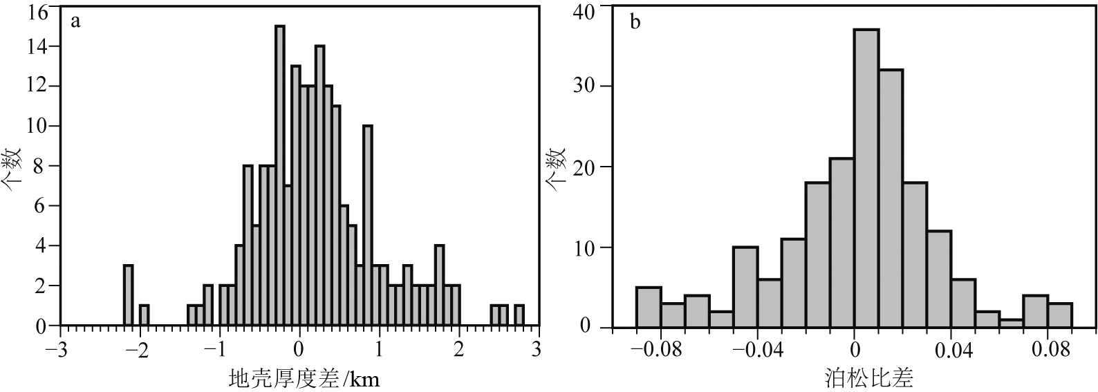
图4 接收函数结果比较
Fig.4 Distribution of observed discrepancies in the crustal thickness (a) and Poisson’s ratio (b) results from this and previous studies

图5 地壳厚度与泊松比插值结果
Fig.5 Interpolated crustal thickness (a) and Poisson’s ratio (b) maps for the study area
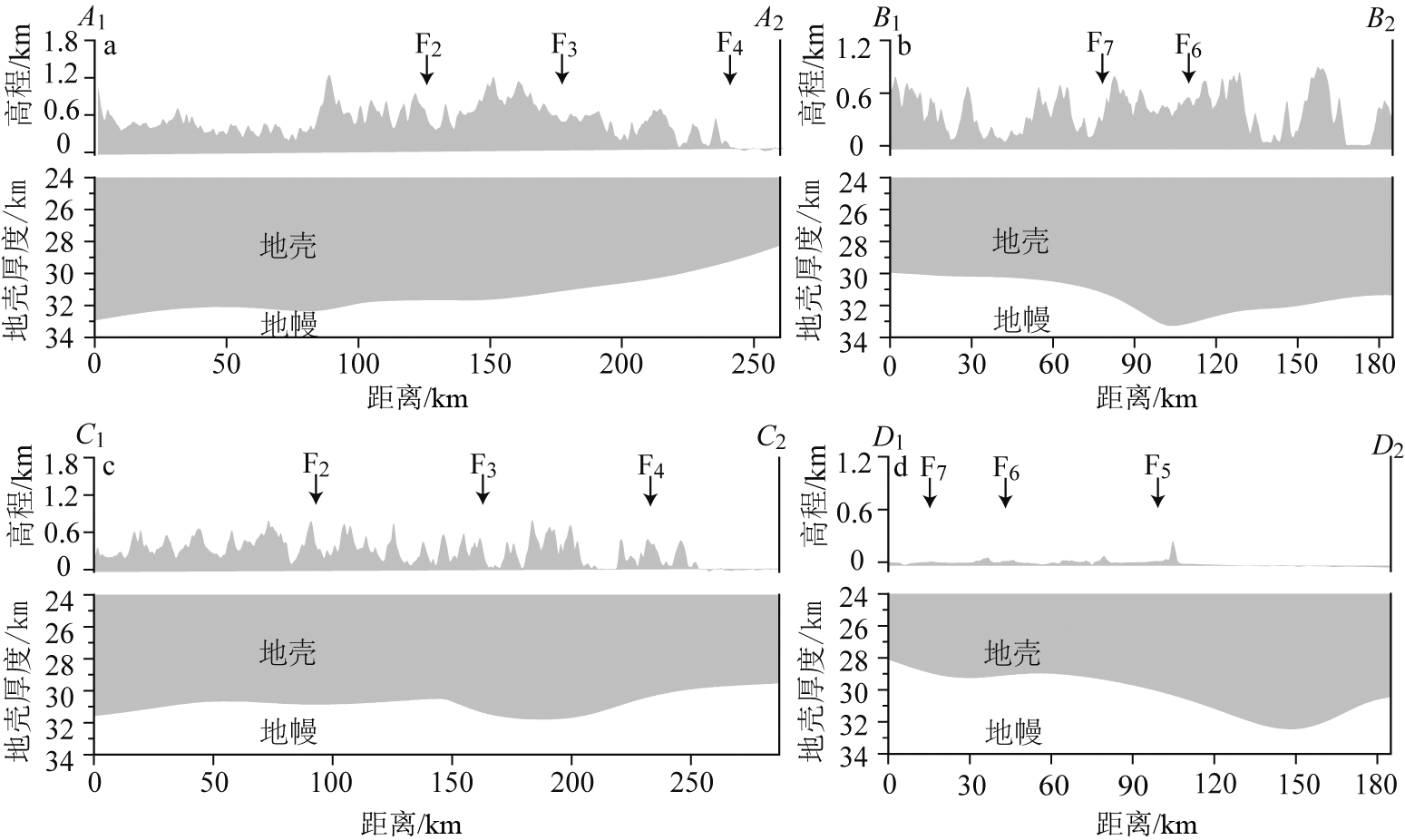
图6 地壳厚度剖面 断裂F1~6位置同图1,剖面位置见图5。
Fig.6 Crustal thickness profiles along survey lines (line locations see Fig.5a)

图7 地壳厚度与泊松比关系 a—福安—南靖断裂带以西(华夏地块); b—福安—南靖断裂带以东(闽浙沿海火山侵入杂岩带)。
Fig.7 Correlations between crustal thickness and Poisson’s ratio in areas to the west (a) and east (b) of the Fu’an-Nanjing fault zone
| [1] | 李霞. 福建省大地构造单元划分及基本特征[J]. 世界地质, 2013, 32(3): 549-557. |
| [2] | 福建省地质调查研究院. 中国区域地质志·福建志[M]. 北京: 地质出版社, 2016. |
| [3] |
LI L M, SUN M, XING G F, et al. Two late Mesozoic volcanic events in Fujian Province: constraints on the tectonic evolution of southeastern China[J]. International Geology Review, 2009, 51(3): 216-251.
DOI URL |
| [4] | 马晓雄, 董传万, 唐立梅, 等. 华南沿海地区中生代岩石圈伸展的岩石学制约: 琼粤闽浙镁铁质岩时空分布与地球化学研究[J]. 浙江大学学报(理学版), 2013, 40(6): 683-692. |
| [5] | 水汀, 阎晋英, 施华生, 等. 政和—大埔断裂带基本特征及其演化模式[J]. 火山地质与矿产, 1993, 14(2): 53-62. |
| [6] | 张路, 曲国胜, 朱金芳, 等. 福建沿海盆地第四纪构造运动模式与动力学环境[J]. 地质通报, 2007, 26(3): 275-288. |
| [7] |
CHARVET J. The Neoproterozoic-Early Paleozoic tectonic evolution of the South China Block: an overview[J]. Journal of Asian Earth Sciences, 2013, 74: 198-209.
DOI URL |
| [8] |
XU X S, O’REILLY S Y, GRIFFIN W L, et al. The crust of Cathaysia: age, assembly and reworking of two terranes[J]. Precambrian Research, 2007, 158(1/2): 51-78.
DOI URL |
| [9] | 林锦华. 长乐—诏安断裂带活动特征与继承性活动[J]. 华南地震, 1999, 19(2): 57-61. |
| [10] | 邢光福, 李龙明, 姜杨, 等. 长乐—南澳构造带白垩纪“片麻状”浆混杂岩的成岩机制研究: 以泉州肖厝岩体为例[J]. 资源调查与环境, 2014, 35(2): 79-94. |
| [11] | 廖其林, 王振明, 王屏路, 等. 福州—泉州—汕头地区地壳结构的爆炸地震研究[J]. 地球物理学报, 1988, 31(3): 270-280. |
| [12] | 廖其林, 王振明, 邱陶兴, 等. 福州盆地及其周围地区地壳深部结构与构造的初步研究[J]. 地球物理学报, 1990, 33(2): 163-173. |
| [13] | 朱金芳, 方盛明, 张先康, 等. 漳州盆地及其邻区地壳深部结构的探测与研究[J]. 中国地震, 2006, 22(4): 405-417. |
| [14] | 李培, 蔡辉腾, 金星, 等. 中国大陆东南缘主要构造带基底结构[J]. 地球物理学报, 2019, 62(8): 2991-3003. |
| [15] | 蔡辉腾, 金星, 王善雄, 等. 宁化—大田—惠安地壳构造与速度结构特征[J]. 地球物理学报, 2016, 59(1): 157-168. |
| [16] |
ZHENG H W, GAO R, LI T D, et al. Collisional tectonics between the Eurasian and Philippine Sea plates from tomography evidences in Southeast China[J]. Tectonophysics, 2013, 606: 14-23.
DOI URL |
| [17] | 李祖宁, 郑勇, 熊熊, 等. 福建—台湾地区地壳构造及其显示的动力学构造研究[J]. 地震研究, 2014, 37(1): 29-38. |
| [18] | 李雪垒, 郝天珧, 李志伟. 中国东南部P波速度结构与构造分析[J]. 地球物理学报, 2020, 63(5): 1802-1815. |
| [19] | 梁富华, 金星, 李军, 等. 福建地区环境噪声瑞利波群速度层析成像[J]. 中国地震, 2012, 28(1): 22-32. |
| [20] | 张丽娜, 罗艳, 陈智勇, 等. 福建及其邻区背景噪声面波群速度层析成像[J]. 地震, 2018, 38(3): 134-143. |
| [21] | ZHANG Y Y, YAO H J, XU M, et al. Upper mantle shear wave velocity structure of southeastern China:seismic evidence for magma activities in the late Mesozoic to the Cenozoic[J]. Geochemistry, Geophysics, Geosystems, 2020, 21(8): e2020GC009103. |
| [22] |
AI Y S, CHEN Q F, ZENG F, et al. The crust and upper mantle structure beneath southeastern China[J]. Earth and Planetary Science Letters, 2007, 260(3/4): 549-563.
DOI URL |
| [23] | 黄晖, 米宁, 徐鸣洁, 等. 福建地区地壳上地幔S波速度结构与泊松比[J]. 高校地质学报, 2010, 16(4): 465-474. |
| [24] | 叶卓, 李秋生, 高锐, 等. 中国大陆东南缘地震接收函数与地壳和上地幔结构[J]. 地球物理学报, 2013, 56(9): 2947-2958. |
| [25] | 黄海波, 郭兴伟, 夏少红, 等. 华南沿海地区地壳厚度与泊松比研究[J]. 地球物理学报, 2014, 57(12): 3896-3906. |
| [26] | 李海艳, 蔡辉腾, 金星, 等. 利用远震P波接收函数研究中国福建地区地壳厚度和泊松比[J]. 地球物理学报, 2021, 64(3): 805-822. |
| [27] | 马金清, 徐维光. 福安—南靖断裂带特征及其地质意义讨论[J]. 福建地质, 2010, 29(1): 67-72. |
| [28] | 赵延娜, 段永红, 魏运浩, 等. 华南大陆东部赣闽地区地壳厚度与泊松比研究[J]. 大地测量与地球动力学, 2017, 37(3): 261-266. |
| [29] |
LIGORRÍA J P, AMMON C J. Iterative deconvolution and receiver-function estimation[J]. Bulletin of the Seismological Society of America, 1999, 89(5): 1395-1400.
DOI URL |
| [30] |
吴佳杰, 徐啸, 郭晓玉, 等. 喜马拉雅造山带东段错那裂谷的地壳结构[J]. 地学前缘, 2022, 29(4): 221-230.
DOI |
| [31] |
KENNETT B L N, ENGDAHL E R, BULAND R. Constraints on seismic velocities in the earth from traveltimes[J]. Geophysical Journal International, 1995, 122(1): 108-124.
DOI URL |
| [32] | 赵延娜, 段永红, 邹长桥, 等. 江西九江—福建宁化接收函数剖面研究[J]. 地震学报, 2015, 37(5): 722-732. |
| [33] |
周鹏哲, 高锐, 叶卓. 祁连山中部地壳各向异性研究:来自远震接收函数的证据[J]. 地学前缘, 2022, 29(4): 265-277.
DOI |
| [34] | ZHU L P, KANAMORI H. Moho depth variation in southern California from teleseismic receiver functions[J]. Journal of Geophysical Research: Solid Earth, 2000, 105(B2): 2969-2980. |
| [35] | 查小惠, 吕坚, 鲍志诚, 等. 接收函数H-κ叠加方法研究综述[J]. CT理论与应用研究, 2020, 29(3): 369-379. |
| [36] | 李细兵, 宋晓东, 郑斯华, 等. 利用人工爆破资料研究福建一维P波速度结构和地震定位[J]. 地球物理学报, 2019, 62(5): 1716-1733. |
| [37] |
WEI Z G, CHEN L, LI Z W, et al. Regional variation in Moho depth and Poisson’s ratio beneath eastern China and its tectonic implications[J]. Journal of Asian Earth Sciences, 2016, 115: 308-320.
DOI URL |
| [38] | 范玉兰, 林纪曾, 胡瑞贺, 等. 华南地区近震走时表的研制[J]. 华南地震, 1990, 10(2): 1-16. |
| [39] |
HE C S, DONG S W, SANTOSH M, et al. Seismic evidence for a geosuture between the Yangtze and Cathaysia blocks, South China[J]. Scientific Reports, 2013, 3: 2200.
DOI PMID |
| [40] | 韩如冰. 中国大陆东南部地壳上地幔间断面形态及多圈层耦合关系研究[D]. 武汉: 中国地质大学(武汉), 2020. |
| [41] |
LI Q S, GAO R, WU F T, et al. Seismic structure in the southeastern China using teleseismic receiver functions[J]. Tectonophysics, 2013, 606: 24-35.
DOI URL |
| [42] | 韩如冰, 李秋生, 徐义贤, 等. 南岭—武夷交汇区的深部背景及地壳泊松比[J]. 地球物理学报, 2019, 62(7): 2477-2489. |
| [43] |
HE R Z, SHANG X F, YU C Q, et al. A unified map of Moho depth and vP/vS ratio of continental China by receiver function analysis[J]. Geophysical Journal International, 2014, 199(3): 1910-1918.
DOI URL |
| [44] | 王培宗, 陈耀安, 曹宝庭, 等. 福建省地壳: 上地幔结构及深部构造背景的研究[J]. 福建地质, 1993, 12(2): 79-158. |
| [45] |
LIN J W, LEE C Y, CHEN C H, et al. Exotic origin of Pingtan Island in the Pingtan-Dongshan Metamorphic Belt (SE China): zircon U-Pb age and Hf isotope evidences[J]. Lithos, 2020, 374/375: 105701.
DOI URL |
| [46] | 邵学钟, 顾忠华, 张家茹. 福州地区地壳结构的地震转换波测深研究[J]. 地震地质, 1993, 15(2): 174-180. |
| [47] |
SEWELL R J, CARTER A, RITTNER M. Middle Jurassic collision of an exotic microcontinental fragment:implications for magmatism across the Southeast China continental margin[J]. Gondwana Research, 2016, 38: 304-312.
DOI URL |
| [48] | 嵇少丞, 王茜, 杨文采. 华北克拉通泊松比与地壳厚度的关系及其大地构造意义[J]. 地质学报, 2009, 83(3): 324-330. |
| [49] |
WANG X L, LIU J X, LÜ Q T, et al. Evolution of deep crustal hot zones constrained by the diversity of Late Mesozoic magmatic rocks in SE China[J]. Ore Geology Reviews, 2021, 134: 104143.
DOI URL |
| [50] |
ZHOU X M, LI W X. Origin of Late Mesozoic igneous rocks in southeastern China: implications for lithosphere subduction and underplating of mafic magmas[J]. Tectonophysics, 2000, 326(3/4): 269-287.
DOI URL |
| [51] |
ZHAO X L, LIU K, YU M G, et al. Early Cretaceous I-type granites in the Southwest Fujian Province: new constraints on the late Mesozoic tectonic evolution of Southeast China[J]. Island Arc, 2015, 24(3): 359-378.
DOI URL |
| [52] |
ZHOU X M, SUN T, SHEN W Z, et al. Petrogenesis of Mesozoic granitoids and volcanic rocks in South China: a response to tectonic evolution[J]. Episodes, 2006, 29(1): 26-33.
DOI URL |
| [53] |
GUO F, FAN W M, LI C W, et al. Multi-stage crust-mantle interaction in SE China: temporal, thermal and compositional constraints from the Mesozoic felsic volcanic rocks in eastern Guangdong-Fujian Provinces[J]. Lithos, 2012, 150: 62-84.
DOI URL |
| [54] |
LIU J X, WANG S, WANG X L, et al. Refining the spatio-temporal distributions of Mesozoic granitoids and volcanic rocks in SE China[J]. Journal of Asian Earth Sciences, 2020, 201: 104503.
DOI URL |
| [55] | 王德滋, 沈渭洲. 中国东南部花岗岩成因与地壳演化[J]. 地学前缘, 2003, 10(3): 209-220. |
| [56] |
ZHANG H, ZHENG J P, PAN S K, et al. Compositions and processes of lithospheric mantle beneath the West Cathaysia block, Southeast China[J]. Lithos, 2017, 286/287: 241-251.
DOI URL |
| [57] | 徐夕生, 谢昕. 中国东南部晚中生代—新生代玄武岩与壳幔作用[J]. 高校地质学报, 2005, 11(3): 318-334. |
| [58] | 张铭杰, 王先彬, 刘刚, 等. 中国东部新生代碱性玄武岩及幔源捕虏体中的流体组成[J]. 地质学报, 1999, 73(2): 162-166. |
| [59] | 檀玉娟, 段永红, 林吉焱, 等. 华南大陆东部地壳物质组成的地震学研究[J]. 地球物理学报, 2021, 64(9): 3150-3163. |
| [60] | 林树, 王紫燕, 李祖宁, 等. 福建地区地壳变形特征研究[J]. 大地测量与地球动力学, 2013, 33(3): 21-24. |
| [61] |
LIU L, XU X S, XIA Y. Cretaceous Pacific plate movement beneath SE China:evidence from episodic volcanism and related intrusions[J]. Tectonophysics, 2014, 614: 170-184.
DOI URL |
| [62] |
SHEN L W, YU J H, O’REILLY S Y, et al. Tectonic switching of Southeast China in the Late Paleozoic[J]. Journal of Geophysical Research: Solid Earth, 2018, 123(10): 8508-8526.
DOI URL |
| [63] | 于津海, 刘潜, 胡修棉, 等. 华南晚古生代岩浆活动的新发现: 岛弧还是陆内造山?[J]. 科学通报, 2012, 57(31): 2964-2971. |
| [64] | 谭皓原, 王志. 中国台湾地区-菲律宾群岛深部纵横波结构成像及其构造意义[J]. 中国地震, 2018, 34(3): 473-483. |
| [65] | 王笋, 丘学林, 赵明辉, 等. 长乐—南澳断裂带两侧地壳结构差异的地震-重力联合反演[J]. 地球物理学报, 2017, 60(10): 3853-3862. |
| [66] | 邱燕, 黄文凯, 杜文波, 等. 南海边缘海减薄陆壳成因剖析[J]. 地球科学, 2021, 46(3): 899-915. |
| [67] |
LIN S F, XING G F, DAVIS D W, et al. Appalachian-style multi-terrane Wilson cycle model for the assembly of South China[J]. Geology, 2018, 46(4): 319-322.
DOI URL |
| [68] |
HE Z Y, XU X S. Petrogenesis of the Late Yanshanian mantle-derived intrusions in southeastern China: response to the geodynamics of paleo-Pacific Plate subduction[J]. Chemical Geology, 2012, 328: 208-221.
DOI URL |
| [69] |
GUO F, WU Y M, ZHANG B, et al. Magmatic responses to Cretaceous subduction and tearing of the paleo-Pacific Plate in SE China: an overview[J]. Earth-Science Reviews, 2021, 212: 103448.
DOI URL |
| [1] | 蔡蔚, 卢占武, 黄荣, 李文辉, 罗银河, 王光文, 穆青, 程永志, 陈司, 王冠, 陈子龙. 基于短周期密集台阵接收函数揭示的藏南错那洞穹窿地壳结构[J]. 地学前缘, 2024, 31(1): 170-180. |
| [2] | 穆青, 黄荣, 严加永, 卢占武, 罗银河, 张永谦, 姜小欢, 文宏斌, 魏鹏龙, 周万里. 利用接收函数H-κ-c叠加方法约束武陵山重力梯度带地壳结构[J]. 地学前缘, 2023, 30(5): 369-383. |
| [3] | 姜小欢, 黄荣, 朱露培, 卢占武, 罗银河, 张荣堂, 徐浩. RF-RTM成像方法研究新疆西准噶尔地区线性台阵下方地壳结构[J]. 地学前缘, 2023, 30(5): 358-368. |
| [4] | 程永志, 高锐, 卢占武, 李文辉, 王光文, 陈司, 吴国炜, 蔡玉国. 青藏高原东北缘祁连造山带东段深部结构及其动力学过程[J]. 地学前缘, 2023, 30(5): 314-333. |
| [5] | 仝霄飞, 徐啸, 郭晓玉, 李春森, 向波, 余嘉豪, 罗旭聪, 袁梓昭, 林燕琪, 时宏城. 接收函数成像揭示东昆仑断裂带及其周缘地壳结构[J]. 地学前缘, 2023, 30(4): 270-282. |
| [6] | 徐啸, 余嘉豪, 向波, 郭晓玉, 李春森, 罗旭聪, 仝霄飞, 袁梓昭, 林燕琪, 时宏城. 拉萨地体东南缘地壳深部结构[J]. 地学前缘, 2023, 30(3): 221-232. |
| [7] | 李春森, 徐啸, 向波, 郭晓玉, 吴优, 吴佳杰, 罗旭聪, 余嘉豪, 仝霄飞, 袁梓昭, 林燕琪. 北喜马拉雅构造带东部Moho形态研究:以接收函数3DCCP方法为例[J]. 地学前缘, 2023, 30(2): 57-67. |
| [8] | 周鹏哲, 高锐, 叶卓. 祁连山中部地壳各向异性研究:来自远震接收函数的证据[J]. 地学前缘, 2022, 29(4): 265-277. |
| [9] | 吴佳杰, 徐啸, 郭晓玉, 卢占武, 吴优, 向波, 于洋, 李春森, 余嘉豪, 仝霄飞, 罗旭聪. 喜马拉雅造山带东段错那裂谷的地壳结构[J]. 地学前缘, 2022, 29(4): 221-230. |
| [10] | Valentina V. MORDVINOVA, Maria A. KHRITOVA, Elena A. KOBELEVA, Mikhail M. KOBELEV, Evgeniy Kh. TURUTANOV, Victor S. KANAYKIN. 远震数据显示贝加尔裂谷带北穆伊斯克(Severomuysk)段地壳和上地幔的精细结构[J]. 地学前缘, 2022, 29(2): 378-392. |
| [11] | 杜书恒, 梁耀欢, 师永民, 关平. 围压-孔压改变条件下致密砂岩及泥页岩泊松比变化特征及机制[J]. 地学前缘, 2021, 28(1): 411-419. |
| [12] | 井翠, 郝龙, 张婧, 邓夏, 於文辉. 四川盆地五峰组—龙马溪组异常地层压力成因与广义泊松比预测方法:以长宁地区为例[J]. 地学前缘, 2021, 28(1): 402-410. |
| [13] | 陈珊, 陆蓉, 刘力辉, 徐兴友, 刘卫彬, 白静. 薄互层干涉对叠前AVO属性的影响分析[J]. 地学前缘, 2020, 27(4): 98-109. |
| [14] | 姜素华,高嵩,李三忠,曹伟,汪刚,张慧璇,赵斐宇. 西太平洋洋陆过渡带重磁异常与构造格架[J]. 地学前缘, 2017, 24(4): 152-170. |
| [15] | 瞿辰, 杨文采, 于常青. 塔里木盆地地震波速扰动及泊松比成像[J]. 地学前缘, 2013, 20(5): 196-206. |
| 阅读次数 | ||||||
|
全文 |
|
|||||
|
摘要 |
|
|||||