Earth Science Frontiers ›› 2025, Vol. 32 ›› Issue (2): 346-356.DOI: 10.13745/j.esf.sf.2023.9.29
Previous Articles Next Articles
CAO Lifu1( ), WANG Haiyan1,2,*(), LI Wenhui1,2, HOU Hesheng2,3, WANG Guangwen1, PANG Yongxiang4
Received:2023-09-04
Revised:2024-06-17
Online:2025-03-25
Published:2025-03-25
CLC Number:
CAO Lifu, WANG Haiyan, LI Wenhui, HOU Hesheng, WANG Guangwen, PANG Yongxiang. Refraction Pg tomographic imaging reveals the upper crustal structure of the Xing-Meng Orogenic Belt and its adjacent areas[J]. Earth Science Frontiers, 2025, 32(2): 346-356.

Fig.1 Wide-angle reflection and refraction profile from south Naiman Banner to north Dongwu Banner. Modified from [1,39,55-56]. a—Location of the study area; b—the location of wide-angle reflection seismic profile.
| 炮点编号 | 类型 | 药量/kg | 经度/(°) | 纬度/(°) | 高程/m |
|---|---|---|---|---|---|
| A1 | 超级大炮 | 2 000 | 121.079 5 | 42.879 45 | 344.8 |
| A2 | 超级大炮 | 2 000 | 120.468 8 | 43.410 83 | 317.8 |
| A3 | 超级大炮 | 2 000 | 119.896 8 | 43.804 93 | 480.6 |
| A4 | 超级大炮 | 2 000 | 119.287 5 | 44.358 15 | 838.5 |
| A5 | 超级大炮 | 2 000 | 118.728 | 44.765 07 | 1 050.4 |
| A6 | 超级大炮 | 2 000 | 118.137 2 | 45.285 52 | 870.843 |
| A7 | 超级大炮 | 2 000 | 117.299 1 | 46.072 28 | 1 003.145 |
| B1 | 大炮 | 480 | 119.642 4 | 44.067 19 | 825.7 |
| B2 | 大炮 | 480 | 119.430 5 | 44.234 45 | 802.0 |
| B3 | 大炮 | 480 | 119.239 1 | 44.384 66 | 854.3 |
| B4 | 大炮 | 480 | 119.046 4 | 44.534 09 | 1 010.0 |
| B5 | 大炮 | 480 | 118.354 3 | 45.021 04 | 987.641 2 |
| B6 | 大炮 | 480 | 118.148 | 45.249 28 | 873.825 4 |
| B7 | 大炮 | 480 | 118.022 4 | 45.380 95 | 838.371 2 |
| B8 | 大炮 | 480 | 117.822 3 | 45.573 06 | 830.414 3 |
| B9 | 大炮 | 480 | 117.625 3 | 45.773 42 | 1 002.713 |
Table 1 Reception of seismic source parameters
| 炮点编号 | 类型 | 药量/kg | 经度/(°) | 纬度/(°) | 高程/m |
|---|---|---|---|---|---|
| A1 | 超级大炮 | 2 000 | 121.079 5 | 42.879 45 | 344.8 |
| A2 | 超级大炮 | 2 000 | 120.468 8 | 43.410 83 | 317.8 |
| A3 | 超级大炮 | 2 000 | 119.896 8 | 43.804 93 | 480.6 |
| A4 | 超级大炮 | 2 000 | 119.287 5 | 44.358 15 | 838.5 |
| A5 | 超级大炮 | 2 000 | 118.728 | 44.765 07 | 1 050.4 |
| A6 | 超级大炮 | 2 000 | 118.137 2 | 45.285 52 | 870.843 |
| A7 | 超级大炮 | 2 000 | 117.299 1 | 46.072 28 | 1 003.145 |
| B1 | 大炮 | 480 | 119.642 4 | 44.067 19 | 825.7 |
| B2 | 大炮 | 480 | 119.430 5 | 44.234 45 | 802.0 |
| B3 | 大炮 | 480 | 119.239 1 | 44.384 66 | 854.3 |
| B4 | 大炮 | 480 | 119.046 4 | 44.534 09 | 1 010.0 |
| B5 | 大炮 | 480 | 118.354 3 | 45.021 04 | 987.641 2 |
| B6 | 大炮 | 480 | 118.148 | 45.249 28 | 873.825 4 |
| B7 | 大炮 | 480 | 118.022 4 | 45.380 95 | 838.371 2 |
| B8 | 大炮 | 480 | 117.822 3 | 45.573 06 | 830.414 3 |
| B9 | 大炮 | 480 | 117.625 3 | 45.773 42 | 1 002.713 |

Fig.2 The seismic record of A1 single shot and its seismic phase travel time picking

Fig.3 A2 shot seismic record cross section (short line is picked Pg seismic phase)

Fig.4 A5 shot seismic record cross section(short line is picked Pg seismic phase)

Fig.5 B7 shot seismic record cross section (short line is picked Pg seismic phase)
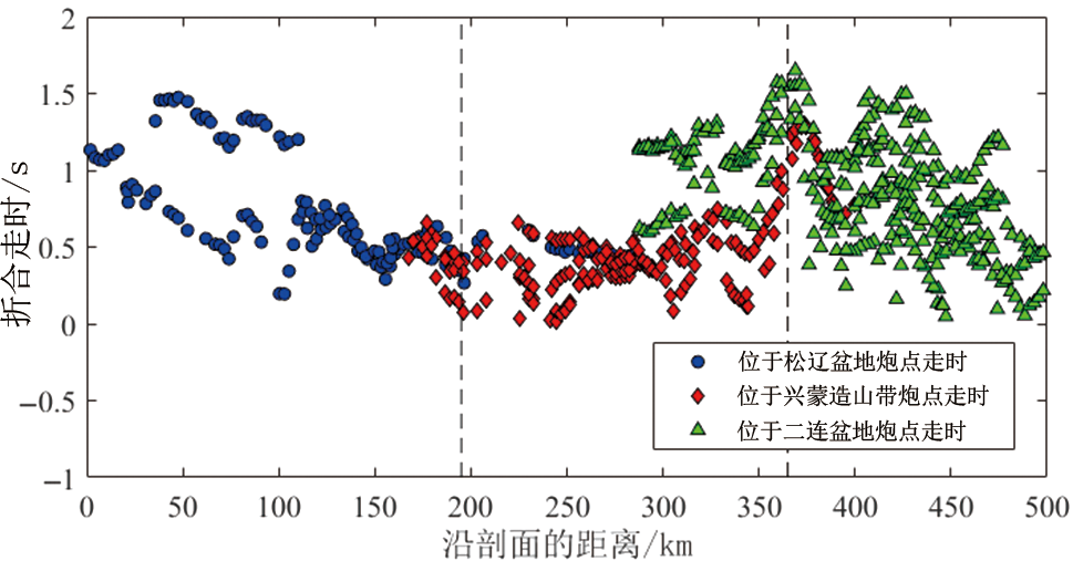
Fig.6 The distribution characteristics of Pg wave travel time data along the profile (reduced velocity at 6.0 km/s)
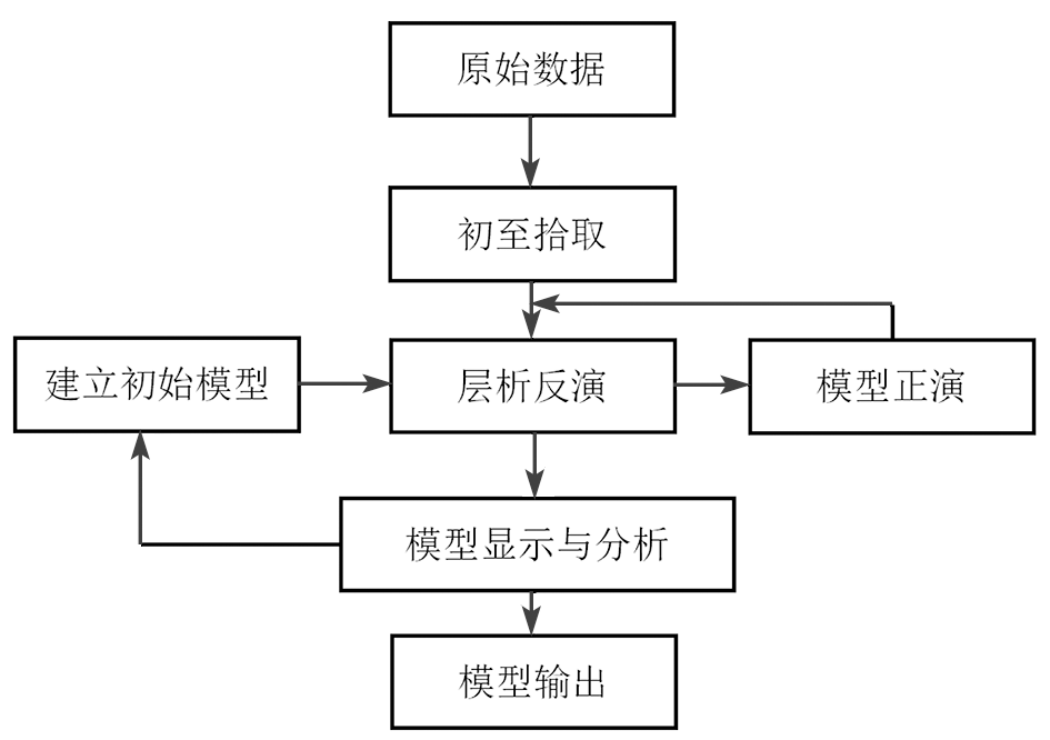
Fig.7 Forward and inversion calculation process. Adapted from [57-58].
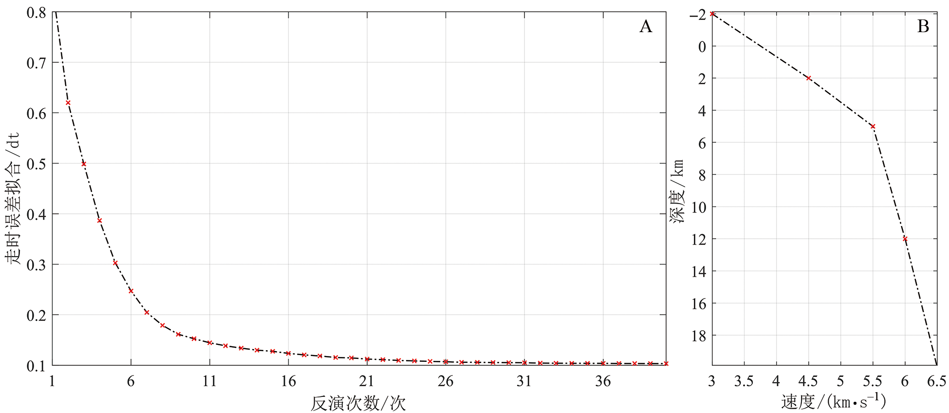
Fig.8 Convergent curve of iterative inversions (A) and 1D initial velocity model (B). Adapted from [9].

Fig.9 Upper crustal velocity model derived from first arrival tomography. The dotted line is the presumed fault, red represents the Cenozoic normal fault, blue represents the late Paleozoic fault, and the arrow represents the direction of movement of the hanging wall of the fault. SCS—Xar Moron suture zone; F1—Nenjiang fault; F2—Daxing’anling main fault; F3—Daqing ranch south fault; HHS—Hegenshan suture zone; F4—Hegenshan fault zone.

Fig.10 Number of rays in tomography cells
| [1] | 李锦轶, 刘建峰, 曲军峰, 等. 中国东北地区主要地质特征和地壳构造格架[J]. 岩石学报, 2019, 35(10): 2989-3016. |
| [2] | 徐备, 王志伟, 张立杨, 等. 兴蒙陆内造山带[J]. 岩石学报, 2018, 34(10): 2819-2844. |
| [3] | 许文良, 孙晨阳, 唐杰, 等. 兴蒙造山带的基底属性与构造演化过程[J]. 地球科学, 2019, 44(5): 1620-1646. |
| [4] | 洪大卫, 王式光, 谢锡林, 等. 试析地幔来源物质成矿域: 以中亚造山带为例[J]. 矿床地质, 2003, 22(1): 41-55. |
| [5] | 侯贺晟, 高锐, 李秋生, 等. 深地震反射剖面揭示的兴蒙造山带地壳精细结构的初步结果[C]// 中国地球物理学会第二十七届年会论文集. 北京: 中国地质科学院地质研究所, 2011. |
| [6] | 谭晓淼, 高锐, 王海燕, 等. 中亚造山带东段深地震反射剖面大炮揭露下地壳与Moho结构: 数据处理与初步解释[J]. 吉林大学学报(地球科学版), 2021, 51(3): 898-908. |
| [7] | 谢樊, 王海燕, 侯贺晟, 等. 中亚造山带东段浅表构造速度结构: 深地震反射剖面初至波层析成像的揭露[J]. 吉林大学学报(地球科学版), 2021, 51(2): 584-596. |
| [8] | 李英康, 高锐, 姚聿涛, 等. 大兴安岭造山带及两侧盆地的地壳速度结构[J]. 地球物理学进展, 2014, 29(1): 73-83. |
| [9] | 王海燕, 李英康, 张晨光, 等. 兴蒙造山带及邻区地壳速度结构特征[J]. 地球物理学报, 2022, 65(5): 1675-1687. |
| [10] | 熊小松, 高锐, 张兴洲, 等. 深地震探测揭示的华北及东北地区莫霍面深度[J]. 地球学报, 2011, 32(1): 46-56. |
| [11] |
龚辰, 李秋生, 叶卓, 等. 远震P波接收函数揭示的张家口(怀来)—中蒙边境(巴音温多尔)剖面地壳厚度与泊松比[J]. 地球物理学报, 2016, 59(3): 897-911.
DOI |
| [12] |
何静, 吴庆举, 张瑞青, 等. 利用接收函数研究兴蒙造山带阿巴嘎地区的地壳结构[J]. 地球物理学报, 2018, 61(9): 3676-3688.
DOI |
| [13] | 姜磊. 华北克拉通与兴蒙造山带地区地壳结构研究[D]. 北京: 中国地震局地球物理研究所, 2021. |
| [14] | 危自根, 陈凌, 杨小林. 辽东台隆、燕山带和兴蒙造山带台站下方地壳厚度和平均波速比(vP/vS)的横向变化及其构造意义[J]. 地球物理学报, 2011, 54(11): 2799-2808. |
| [15] | 涂广红, 江为为, 朱东英, 等. 中国东北地区剩余重磁异常特征与地质构造及成矿带的关系[J]. 地球物理学进展, 2006, 21(3): 746-755. |
| [16] | 王学刚, 曾昭发, 孙晓东, 等. 兴蒙造山带区域矿产空间分布与重磁异常特征关系研究[J]. 世界地质, 2017, 36(4): 1209-1218. |
| [17] | 张凤旭, 张兴洲, 张凤琴, 等. 中国东北地区重力场研究: 利用改进的三方向小子域滤波划分主构造线及大地构造单元[J]. 地球物理学报, 2010, 53(6): 1475-1485. |
| [18] |
张凯文, 陈棋福, 陈赟. 接收函数揭示的兴蒙造山带西南部的地壳结构特征[J]. 地球物理学报, 2020, 63(4): 1484-1504.
DOI |
| [19] |
韩江涛, 康建强, 刘财, 等. 中亚造山带东段软流圈分布特征: 基于长周期大地电磁探测的结果[J]. 地球物理学报, 2019, 62(3): 1148-1158.
DOI |
| [20] | 梁宏达. 大陆岩石圈电性结构研究:以大兴安岭、华北北缘、秦岭为例[D]. 北京: 中国地质科学院, 2015. |
| [21] | 慕倩, 韩江涛, 刘立家, 等. 切穿兴蒙造山带的深断面: 岩石圈电性结构及改造模式[J]. 地球物理学报, 2023, 66(4): 1603-1617. |
| [22] | KRÖNER A, KOVACH V, BELOUSOVA E, et al. Reassessment of continental growth during the accretionary history of the Central Asian Orogenic Belt[J]. Gondwana Research, 2014, 25(1): 103-125. |
| [23] | ŞENGÖR A M C, NATAL’IN B A, BURTMAN V S. Evolution of the Altaid tectonic collage and Palaeozoic crustal growth in Eurasia[J]. Nature, 1993, 364(6435): 299-307. |
| [24] | WINDLEY B F, ALEXEIEV D, XIAO W J, et al. Tectonic models for accretion of the Central Asian Orogenic Belt[J]. Journal of the Geological Society, 2007, 164(1): 31-47. |
| [25] | MENG F C, AI Y S, XU T, et al. Lithospheric structure beneath the boundary region of North China Craton and Xing Meng Orogenic Belt from S-receiver function analysis[J]. Tectonophysics, 2021, 818: 229067. |
| [26] | GOU J, SUN D Y, MAO A Q, et al. Geochronology and geochemistry of Ordovician plutons in the erguna block (NE China): further insights into the tectonic evolution of the Xing’an-Mongolia Orogenic Belt[J]. International Geology Review, 2019, 61(8): 936-955. |
| [27] | WANG R L, ZENG Q D, ZHANG Z C, et al. Extensive mineralization in the eastern segment of the Xingmeng Orogenic Belt, NE China: a regional view[J]. Ore Geology Reviews, 2021, 135: 104204. |
| [28] | 葛文春, 吴福元, 周长勇, 等. 兴蒙造山带东段斑岩型Cu, Mo矿床成矿时代及其地球动力学意义[J]. 科学通报, 2007, 52(20): 2407-2417. |
| [29] | 李可, 张志诚, 冯志硕, 等. 兴蒙造山带中段北部晚古生代两期岩浆活动及其构造意义[J]. 地质学报, 2015, 89(2): 272-288. |
| [30] | 李双林, 欧阳自远. 兴蒙造山带及邻区的构造格局与构造演化[J]. 海洋地质与第四纪地质, 1998, 18(3): 46-55. |
| [31] | 邵济安, 臧绍先, 牟保磊, 等. 造山带的伸展构造与软流圈隆起: 以兴蒙造山带为例[J]. 科学通报, 1994, 39(6): 533-537. |
| [32] | 徐备, 赵盼, 鲍庆中, 等. 兴蒙造山带前中生代构造单元划分初探[J]. 岩石学报, 2014, 30(7): 1841-1857. |
| [33] | 张焱杰, 徐备, 田英杰, 等. 兴蒙造山带晚古生代伸展过程: 来自二连浩特东北部石炭—二叠系沉积地层的证据[J]. 岩石学报, 2018, 34(10): 3083-3100. |
| [34] | DOBRETSOV N L, BERZIN N A, BUSLOV M M. Opening andtectonic evolution of the Paleo-Asian Ocean[J]. International Geology Review, 1995, 37(4): 335-360. |
| [35] | SAFONOVA I Y, SANTOSH M. Accretionary complexes in the Asia-Pacific Region: tracing archives of ocean plate stratigraphy and tracking mantle plumes[J]. Gondwana Research, 2014, 25(1): 126-158. |
| [36] | SENGOR A. Paleotectonics of Asia: fragments of a synthesis[J]. World and Regional Geology, 1996, 1(8): 486-640. |
| [37] | 程银行. 松辽盆地晚白垩世以来沉积充填及构造演化研究[D]. 北京: 中国地质大学(北京), 2019. |
| [38] | 胡望水, 吕炳全, 张文军, 等. 松辽盆地构造演化及成盆动力学探讨[J]. 地质科学, 2005, 40(1): 16-31. |
| [39] | 葛荣峰, 张庆龙, 王良书, 等. 松辽盆地构造演化与中国东部构造体制转换[J]. 地质论评, 2010, 56(2): 180-195. |
| [40] | 李娟, 舒良树. 松辽盆地中、新生代构造特征及其演化[J]. 南京大学学报(自然科学), 2002, 38(4): 525-531. |
| [41] | 刘招君, 柳蓉. 中国油页岩特征及开发利用前景分析[J]. 地学前缘, 2005, 12(3): 315-323. |
| [42] | ZHAO W J, ZHU H, DING Q H. Large scale magnetotelluric sounding at the periphery of the Songliao Basin, NE China[J]. ASEG Extended Abstracts, 2016, 2016(1): 1-8. |
| [43] | 郭巍, 刘招君, 董惠民, 等. 松辽盆地层序地层特征及油气聚集规律[J]. 吉林大学学报(地球科学版), 2004, 34(2): 216-221. |
| [44] | 舒良树, 慕玉福, 王伯长. 松辽盆地含油气地层及其构造特征[J]. 地层学杂志, 2003, 27(4): 340-347. |
| [45] | 王璞珺, 迟元林, 刘万洙, 等. 松辽盆地火山岩相: 类型、特征和储层意义[J]. 吉林大学学报(地球科学版), 2003, 33(4): 449-456. |
| [46] | 王璞珺, 吴河勇, 庞颜明, 等. 松辽盆地火山岩相: 相序、相模式与储层物性的定量关系[J]. 吉林大学学报(地球科学版), 2006, 36(5): 805-812. |
| [47] | LI Y N, WANG S, YE Z R, et al. The sedimentary filling differences of subsags and their impacts on oil shale and coal accumulation in a rift lacustrine sag: a case study from the lower Cretaceous in the Zhangqiang Sag, southern Songliao Basin, Northeast China[J]. Marine and Petroleum Geology, 2023, 155: 106354. |
| [48] |
贾承造, 邹才能, 李建忠, 等. 中国致密油评价标准、 主要类型、 基本特征及资源前景[J]. 石油学报, 2012, 33(3): 343-350.
DOI |
| [49] | 王璞珺, 杜小弟, 王俊, 等. 松辽盆地白垩纪年代地层研究及地层时代划分[J]. 地质学报, 1995, 69(4): 372-381. |
| [50] | 张兴洲, 周建波, 迟效国, 等. 东北地区晚古生代构造-沉积特征与油气资源[J]. 吉林大学学报(地球科学版), 2008, 38(5): 719-725. |
| [51] | 任建业, 李思田, 焦贵浩. 二连断陷盆地群伸展构造系统及其发育的深部背景[J]. 地球科学: 中国地质大学学报, 1998, 23(6): 24-29. |
| [52] | 刘陟娜, 乔鹏, 阎学成, 等. 二连盆地哈达图铀矿床铀赋存特征研究及成因探讨[J]. 东华理工大学学报(自然科学版), 2022, 45(4): 372-381. |
| [53] | 伍显红, 许第桥, 李茂. 宽频大地电磁法在二连盆地铀矿资源评价中的试验应用[J]. 物探与化探, 2022(4): 830-837. |
| [54] | 肖安成, 杨树锋, 陈汉林. 二连盆地形成的地球动力学背景[J]. 石油与天然气地质, 2001, 22(2): 137-140, 145. |
| [55] | 周建波, 石爱国, 景妍. 东北地块群: 构造演化与古大陆重建[J]. 吉林大学学报(地球科学版), 2016, 46(4): 1042-1055. |
| [56] | 张凤旭, 姚欢, 张兴洲, 等. 二连盆地“三明治” 电性结构特征及其对古生界的研究意义[J]. 地球物理学报, 2012, 55(9): 3134-3143. |
| [57] | HOLE J A. Nonlinear high-resolution three-dimensional seismic travel time tomography[J]. Journal of Geophysical Research: Solid Earth, 1992, 97(B5): 6553-6562. |
| [58] | VIDALE J E. Finite-difference calculation of traveltimes in three dimensions[J]. Geophysics, 1990, 55(5): 521-526. |
| [59] |
李文辉, 王海燕, 高锐, 等. 秦岭造山带及邻区上地壳精细速度结构研究[J]. 地学前缘, 2022, 29(2): 198-209.
DOI |
| [60] | CHRISTENSEN N I, MOONEY W D. Seismic velocity structure and composition of the continental crust: a globalview[J]. Journal of Geophysical Research: Solid Earth, 1995, 100(B6): 9761-9788. |
| [61] |
郭文斌, 嘉世旭, 段永红, 等. 青藏高原东北缘基底结构研究: 玛多—共和—雅布赖剖面上地壳地震折射探测[J]. 地球物理学报, 2016, 59(10): 3627-3636.
DOI |
| [62] | 王夫运, 段永红, 杨卓欣, 等. 川西盐源—马边地震带上地壳速度结构和活动断裂研究: 高分辨率地震折射实验结果[J]. 中国科学D辑: 地球科学, 2008, 38(5): 611-621. |
| [63] |
徐涛, 张明辉, 田小波, 等. 丽江—清镇剖面上地壳速度结构及其与鲁甸Ms6.5级地震孕震环境的关系[J]. 地球物理学报, 2014, 57(9): 3069-3079.
DOI |
| [64] | 张欲清. 内蒙古克什克腾—林西地区晚古生代—中生代构造变形与西拉木伦缝合带构造演化[D]. 北京: 中国地质大学(北京), 2016. |
| [65] | 葛荣峰. 松辽盆地中部断陷期构造演化与地壳伸展[D]. 南京: 南京大学, 2011. |
| [66] | 崔永谦, 刘喜恒, 孙朝辉, 等. 内蒙古二连盆地深层地球物理特征和上古生界的地质结构[J]. 地质通报, 2011, 30(增刊1): 235-242. |
| [67] | 郭阳阳. 二连盆地乌尼特坳陷重力场及构造特征研究[D]. 西安: 西安石油大学, 2019. |
| [68] | 祝玉衡, 张文朝. 二连盆地层序地层样式及油气意义[J]. 石油勘探与开发, 1999, 26(4): 49-53, 5. |
| [1] | WANG Bin, SUN Dongsheng, LI Awei, YANG Yuehui, CHEN Qunce. In situ stress state of deep basement in the Songliao Basin: Evidence from in situ stress measurement in SK-2 borehole [J]. Earth Science Frontiers, 2024, 31(2): 377-390. |
| [2] | WANG Chengshan, GAO Yuan, WANG Pujun, WU Huaichun, LÜ Qingtian, ZHU Yongyi, WAN Xiaoqiao, ZOU Changchun, HUANG Yongjian, GAO Youfeng, XI Dangpeng, WANG Wenshi, HE Huaiyu, FENG Zihui, YANG Guang, DENG Chenglong, ZHANG Laiming, WANG Tiantian, HU Bin, CUI Liwei, PENG Cheng, YU Enxiao, HUANG He, YANG Liu, WU Zhengxuan. International Continental Scientific Drilling Project of the Songliao Basin: Terrestrial Geological Records of the Cretaceous Dinosaur Age [J]. Earth Science Frontiers, 2024, 31(1): 412-430. |
| [3] | WU Huaichun, LI Shan, WANG Chengshan, CHU Runjian, WANG Pujun, GAO Yuan, WAN Xiaoqiao, HE Huaiyu, DENG Chenglong, YANG Guang, HUANG Yongjian, GAO Youfeng, XI Dangpeng, WANG Tiantian, FANG Qiang, YANG Tianshui, ZHANG Shihong. Integrated chronostratigraphic framework for Cretaceous strata in the Songliao Basin [J]. Earth Science Frontiers, 2024, 31(1): 431-445. |
| [4] | XIANG Xin, HUANG Chuanyan, CAO Lanzhu, CAO Qiang, JIANG Tao, ZHANG Yufei, SONG Yu, XU Jie. Enrichment model and exploration potential for unconventional oil and gas in troughs, Erlian Basin [J]. Earth Science Frontiers, 2023, 30(6): 462-472. |
| [5] | LI Ruilei, YANG Liying, ZHU Jianfeng, LIU Yuhu, XU Wen, LI Zhongbo, FAN Xuepei, LENG Qinglei, ZHANG Tingting. Volcanic reservoir characteristics and hydrocarbon accumulation control factors of rift depressions in southern Songliao Basin [J]. Earth Science Frontiers, 2023, 30(4): 100-111. |
| [6] | GAO Hang, WANG Pujun, GAO Youfeng, WAN Xiaoqiao, YANG Guang, HU Jingsong, WU Huaichun. The Upper-Lower Cretaceous boundary in the southern Songliao Basin: A case study of ICDP borehole SK-3 [J]. Earth Science Frontiers, 2023, 30(3): 425-440. |
| [7] | GUO Zhixin, YANG Yongtai, REN Yi, WANG Zhengqing, FENG Zhigang, CHEN Liang, TANG Zhenping. Emplacement and episodic denudation of basement granites from the southern Jiergalangtu Sag, Erlian Basin and its tectonic implications [J]. Earth Science Frontiers, 2023, 30(2): 259-271. |
| [8] | LI Wenhui, WANG Haiyan, GAO Rui, LU Zhanwu, LI Hongqiang, HOU Hesheng, XIONG Xiaosong, YE Zhuo. Detailed upper crustal velocity structure beneath the Qinling Orogen and adjacent region [J]. Earth Science Frontiers, 2022, 29(2): 198-209. |
| [9] | HAN Shuangbiao, TANG Zhiyuan, BAI Songtao, WAN Lei, RUI Yurun, GAO Yuan, HUANG Yongjian, WANG Chengshan. Application of elemental capture spectroscopy in deep tight reservoir evaluation: A case study of well SK-2 [J]. Earth Science Frontiers, 2022, 29(1): 449-458. |
| [10] | QU Xuejiao, GAO Youfeng, LIN Zhicheng, WANG Pujun, WU Kangjun. Discussion on the characteristics of the Jurassic-Cretaceous boundary correlation in the Songliao Basin and adjacent areas [J]. Earth Science Frontiers, 2021, 28(4): 299-315. |
| [11] | WEI Wei, ZHU Xiaomin, ZHU Shifa, HE Mingwei, SUN Shuyang, WANG Mingwei. Characteristics and control mechanism of high quality reservoir of lacustrine dolomitic rocks from the Lower Cretaceous of the Erennaoer Sag, Erlian Basin, northeastern China [J]. Earth Science Frontiers, 2021, 28(1): 214-224. |
| [12] | DU Shuheng, LIANG Yaohuan, SHI Yongmin, GUAN Ping. Variations of Poisson’s ratio for tight sandstone and shale under changing confining or pore pressure: Characteristics and mechanism [J]. Earth Science Frontiers, 2021, 28(1): 411-419. |
| [13] | NIU Huapeng,WANG Guiwen,XIAN Benzhong,FU Jianwei,JIAO Xiaoqin,LI Hongjuan. The formation mechanism of pyroclastic lava and its significance for the identification of volcanic rock faces: a case study from Qingshen gasfield, Songliao Basin [J]. Earth Science Frontiers, 2019, 26(6): 281-288. |
| [14] | WEI Wei,ZHU Xiaomin,ZHU Shifa,SUN Shuyang,WU Jianping,WANG Mingwei,L Sihan. Petrologic and diagenetic characteristics of the lacustrine volcanicsiliciclastic tight reservoir: an example from the first member of the Tenggeer Formation in the Lower Cretaceous, Anan Sag, [J]. Earth Science Frontiers, 2018, 25(2): 147-158. |
| [15] | SONG Ying, ZHANG Dun-Xia, Andrei Stepashko, YUAN Mo-Meng, CONG Xu-Ri. Decomposition the detrital grain ages by Kernel Density Estimation and its applications: Determining the major tectonic events in the Songliao Basin, NE China. [J]. Earth Science Frontiers, 2016, 23(4): 265-276. |
| Viewed | ||||||
|
Full text |
|
|||||
|
Abstract |
|
|||||