地学前缘 ›› 2024, Vol. 31 ›› Issue (1): 154-169.DOI: 10.13745/j.esf.sf.2024.1.146
• 青藏高原结构构造及成矿效应(“印度-欧亚大陆碰撞及其远程效应”专栏之十) • 上一篇 下一篇
刘德民1( ), 王杰2,3,*(), 姜淮1, 赵悦1, 郭铁鹰1, 杨巍然1
收稿日期:2024-01-04
修回日期:2024-01-20
出版日期:2024-01-25
发布日期:2024-01-25
通信作者:
*王 杰(1981—),男,博士,高级工程师,主要从事构造地质与地震监测预报研究。E-mail: 作者简介:刘德民(1975—),男,博士,副教授,主要从事构造地质学与地热地质学方面的教学和研究。E-mail: 5guc@163.com
基金资助:
LIU Demin1(), WANG Jie2,3,*(), JIANG Huai1, ZHAO Yue1, GUO Tieying1, YANG Weiran1
Received:2024-01-04
Revised:2024-01-20
Online:2024-01-25
Published:2024-01-25
摘要:
作为第三极的青藏高原的形成是新生代以来的地球节律构造事件中最典型、最显著的新构造运动的结果,其构造地貌特征及其重要性,内部单元组成,构造演化历程及动力机制,以及对周边盆地乃至整个中国大陆的影响及远程效应至今一直是学术关注的焦点。本文重新圈定了青藏高原构造地貌范围,确立了其在全球构造中的地位。青藏高原的远程效应向南北两侧延伸,北到北冰洋,南到太平洋,总体上围绕东经105°经线穿越了整个亚洲大陆,本文采用东经105°所在经线大圆作为划分东西半球的分界线,该线以东为东半球,以西为西半球。青藏高原处于全球最大、最重要的南北向构造和东西向构造的交汇处,其内部的帕米尔高原更是区域构造的中流砥柱。青藏高原起源于帕米尔高原,它是一个印支期的热穹窿,晚期转化出一条直径200 km的异常重力柱,垂直下沉至600 km,构成一个垂向上的挤压-伸展构造,完成于白垩纪。以它为中心向东西扩展,东边三条、西边一条水平方向挤压-伸展构造。喜山期它还遭受到岩体的侵入,白垩系基本上未变形。古近纪,印度陆块与亚洲陆块碰撞,形成先压后升的雄伟的喜马拉雅造山带。以它为中心向北扩展,第四纪3个地幔枝上升,导致整个青藏高原上升。青藏高原形成与演化的深部动力机制模型:早期表现为地质体在垂向上的离心运动和在水平上的伸展运动;后期是以挤压为主的阶段,表现为地质体在垂向上的向心运动和水平上的挤压运动。从驱动力的角度,早期以热能为主驱动力,后期以重力势能为主驱动力。青藏高原的隆升及其形成演化是欧亚陆块新生代最令人瞩目的地质事件,其直接影响到岩石圈浅部及地壳表层与人类生存发展息息相关的地形地貌、能源、资源、生态、环境和灾害等,产生了具有举足轻重的近区及远程效应。3个远程效应分别是贝加尔湖裂谷、汾渭裂谷以及东非三叉裂谷的形成。本文最后对印支运动的命名和穿时问题、印支运动起止时间和类型、青藏高原是研究各类造山带的最佳基地、喜马拉雅造山带东西构造结的确定和帕米尔高原四维动力学模型的探索等5个问题进行了简单讨论。
中图分类号:
刘德民, 王杰, 姜淮, 赵悦, 郭铁鹰, 杨巍然. 青藏高原形成演化动力机制及其远程效应[J]. 地学前缘, 2024, 31(1): 154-169.
LIU Demin, WANG Jie, JIANG Huai, ZHAO Yue, GUO Tieying, YANG Weiran. Evolutionary geodynamics and remote effects of the uplift of the Qinghai-Tibet Plateau[J]. Earth Science Frontiers, 2024, 31(1): 154-169.

图1 全球地势图
Fig.1 Global topographic map

图2 青藏高原范围及其构造位置图(据文献[9-10]修改)
Fig.2 Range and tectonic setting of the Qinghai-Tibet Plateau. Modified after [9-10].

图3 帕米尔挤压热穹窿区地质简图(据文献[14]修改)
Fig.3 Geological sketch map of the Pamir Compressional Geothermal Dome. Modified after [14].

图4 帕米尔片麻岩穹窿内部构造及结构示意图(据文献[15]修改) a—内部构造:1—片麻岩穹窿;2—新生代花岗岩;3—片麻岩穹窿的轴;4—正断层;5—拆离断层;6—逆冲断层;7—走滑断层。b—结构示意图。
Fig.4 Sketch maps of the Pamir Gneiss Dome Structure. Modified after [15].

图5 青藏高原及邻区构造单元划分图(据文献[14,16]修改) 1—拆离断层;2—逆冲断层;3—走滑断层;4—伸展变质热穹窿;5—滑来峰;6—基底出露区;7—蛇绿岩;8—极高山及编号;9—高原区;10—陆块区;11—对接带;12—构造结范围。极高山有:1—干城吉嘉峰(8 585 m);2—马克鲁峰(8 463 m);3—珠穆朗玛峰(8 848 m);4—希夏邦马峰(8 027 m);5—马纳斯卢峰(8 156 m);6—安纳布尔纳峰(8 078 m);7—道拉吉里峰(8 172 m)。伸展变质热穹窿有:A—多布榨变质热穹窿;B—拉轨岗日变质热穹窿;C,D—康马变质热穹窿;E—然巴变质变穹窿;F—雅拉香波变质热穹窿。
Fig.5 Structural units of the Qinghai-Tibet Plateau and adjacent areas. Modified after [14,16].
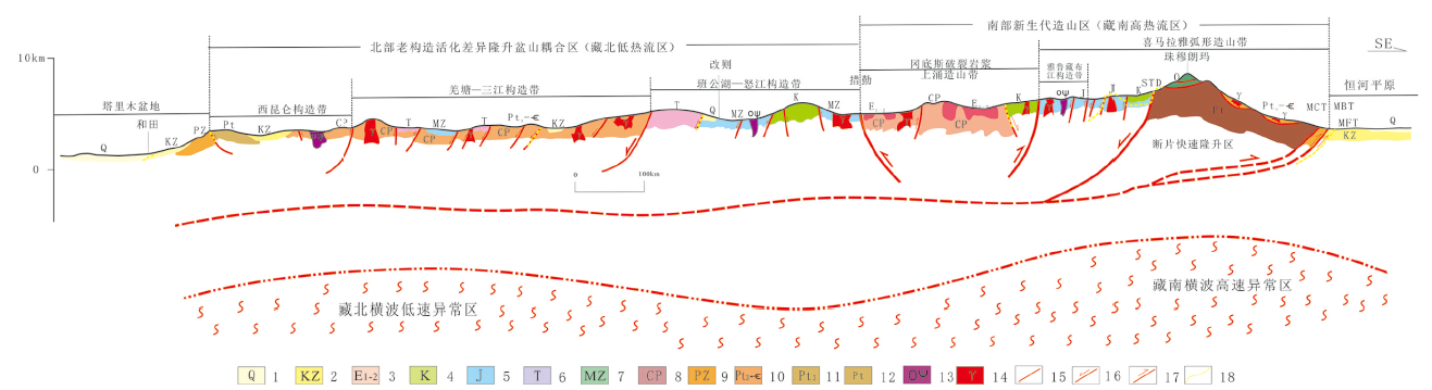
图6 青藏高原内部结构与深部构造关系剖 (据文献[21]修改) 1-第四系:2-新生界;3-古新统-始新统;4-白垩系;5-侏罗系;6三叠系;7-中生界;8-石炭-二叠系;9-古生界;10新元古界-寒武系;11-新元古界;12-元古宇;13-蛇绿岩;14-花岗岩类;15-性质不明断层;16-正断层;17-逆断层;18-新生代活化的断层。
Fig.6 Sectional map showing the relationship between the interal structure, fragmented stnucture, and dep structure of the Qinghai-Tibet Plateau. Modiied after [21].

图7 青藏高原地质与地球物理图(据文献[32]修改) 1—>100 ℃温泉;2—<100 ℃温泉;3—中新世—第四纪火山岩;4—晚渐新世-中新世火山岩;5—始新世-渐新世火山岩;6—古近纪林子宗群火山岩;7—新生代火山群;8—活动断层;9—青藏高原构造地貌边界;10—地幔热隆的地表投影;11—弧形构造。
Fig.7 Geological and geophysical maps of the Qinghai-Tibet Plateau. Modified after [32].
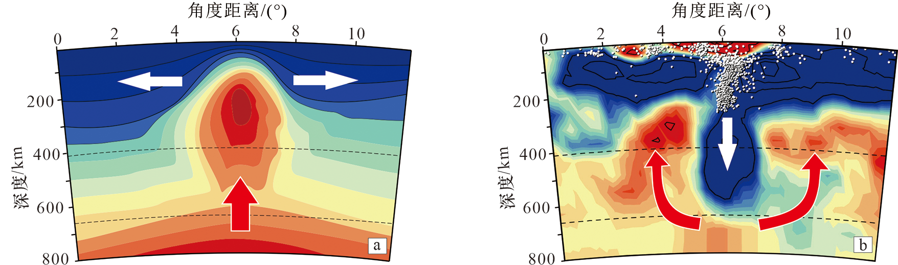
图8 青藏高原形成与演化的动力机制模型(据文献[33]修改) a—早期:地幔热隆与伸展阶段;b—后期:地壳碰撞与重力均衡阶段。
Fig.8 Dynamics model for the formation and evolution of the Qinghai-Tibet Plateau. Modified after [33].

图9 青藏高原隆起远程效应图
Fig.9 Map showing the direction and range of remote effects of the Qinghai-Tibet Plateau uplift
| [1] |
ADLAKHA V, LANG K A, PATEL R C. Rapid long-term erosion in the rain shadow of the Shilong Plateau, Eastern Himalaya[J]. Tectonophysics, 2013, 582: 76-83.
DOI URL |
| [2] |
YIN A, HARRISON T M. Geologic evolution of the Himalayan-Tibetan Orogen[J]. Annual Review of Earth and Planetary Sciences, 2000, 28(1): 211-280.
DOI URL |
| [3] |
赵俊猛, 张培震, 张先康, 等. 中国西部壳幔结构与动力学过程及其对资源环境的制约: “羚羊计划” 研究进展[J]. 地学前缘, 2021, 28(5): 230-259.
DOI |
| [4] | 潘桂棠, 刘宇平, 郑来林, 等. 青藏高原碰撞构造与效应[M]. 广州: 广东科技出版社, 2013. |
| [5] | 潘桂棠, 王立全, 尹福光, 等. 青藏高原形成演化研究回顾、 进展与展望[J]. 沉积与特提斯地质, 2022, 42(2): 151-175. |
| [6] | 吴珍汉, 吴中海, 胡道功, 等. 青藏高原新生代构造演化与隆升过程[M]. 北京: 地质出版社, 2009. |
| [7] | 韩慕康. 构造地貌学[J]. 地球科学进展, 1992, 7(5): 61-62. |
| [8] | 刘德民, 李德威, 谢德凡, 等. 喜马拉雅造山带中段北坡构造地貌初步研究[J]. 地球科学: 中国地质大学学报, 2003, 28(6): 639-644. |
| [9] | 马宗晋, 杜品仁, 高祥林. 全球构造研究的思考[J]. 地学前缘, 2003(增刊): 1-4. |
| [10] | 马瑾, 郭彦双. 失稳前断层加速协同化的实验室证据和地震实例[J]. 地震地质, 2014, 36(3): 547-560. |
| [11] |
BURKE K. Plate tectonics the Wilson Cycle and mantle plumes: geodynamics from the Top[J]. Annual Review of Earth and Planetary Sciences, 2011, 39: 1-29.
DOI URL |
| [12] | 马宗晋, 郑大林. 中蒙大陆中轴构造带及其地震活动[J]. 地震研究, 1981(4): 421-436. |
| [13] |
刘德民, 杨巍然, 郭铁鹰. 藏南地区新生代多阶段构造演化及其动力学的探讨[J]. 地学前缘, 2020, 27(1): 194-203.
DOI |
| [14] | 任纪舜. 1∶500万国际亚洲地质图[CM]. 北京: 地质出版社, 2013. |
| [15] | 许志琴, 马绪宣. 中国大陆显生宙俯冲型、 碰撞型和复合型片麻岩穹窿(群)[J]. 岩石学报, 2015, 31(12): 3509-3523. |
| [16] | 李江海. 全球中新生代大地构造图及说明书[M]. 北京: 科学出版社, 2017. |
| [17] |
杨巍然, 姜春发, 张抗, 等. 运用开合旋构造观探究地球内部是如何运行的[J]. 地学前缘, 2020, 27(1): 204-210.
DOI |
| [18] | 杨巍然, 王新华, 徐文燕. 怀柔汤河口地区推覆构造特征. 地质科技情报, 1973(5): 102-113. |
| [19] | 杨巍然. 论造山作用和造山带[J]. 地学前缘, 1999, 6(1): 10-14. |
| [20] |
任雅琼, 马瑾, 刘培洵, 等. 平直断层黏滑过程热场演化及失稳部位识别的实验研究[J]. 地震地质, 2016, 38(1): 65-76.
DOI |
| [21] | 杨巍然, 王杰, 梁晓. 亚洲大地构造基本特征和演化规律[J]. 地学前缘, 2012, 19(5): 1-17. |
| [22] |
TURNER S, HAWKESWORTH C, LIU J, et al. Timing of Tibetan uplift constrained by analysis of volcanic rocks[J]. Nature, 1993, 364: 50-54.
DOI |
| [23] |
AN Z S, JOHN E K, WARREN L P, et al. Evolution of Asian monsoons and phased uplift of the Himalaya-Tibetan Plateau since Late Miocene times[J]. Nature, 2001, 411: 62-66.
DOI |
| [24] |
SPICER R A, HARRIS N B W, WIDDOWSON M, et al. Constant elevation of southern Tibet over the past 15 million years[J]. Nature, 2003, 421: 622-624.
DOI |
| [25] |
CURRIE B S, ROWLEY D B, TABOR N J. Middle Miocene paleoaltimetry of southern Tibet: implications for the role of mantle thickening and delamination in the Himalayan orogen[J]. Geology, 2005, 33: 181-184.
DOI URL |
| [26] |
COLEMAN M E, HODGES K V. Evidence for Tibetan Plateau uplift before 14 m.y. ago from a new minimum estimate for east-west extension[J]. Nature, 1995, 374(6517): 49-52.
DOI |
| [27] | 李晓蓉, 张波, 张进江, 等. 喜马拉雅造山带亚东地区晚新生代剥露历史及其构造意义: 来自磷灰石和锆石(U-Th)/He数据的约束[J]. 岩石学报, 2022, 96(4): 1143-1162. |
| [28] |
GRUJIC D, COUTAND I, BOOKHAGEN B, et al. Climate forcing of erosion, landscape, and tectonics in the Bhutan Himalayas[J]. Geology, 2006, 34: 801-804.
DOI URL |
| [29] |
FANG X M, ZHANG W L, MENG Q Q, et al. High-resolution magnetostratigraphy of the Neogene Huaitoutala section in the eastern Qaidam Basin on the NE Tibetan Plateau, Qinghai Province, China and its implication on tectonic uplift of the NE Tibetan Plateau[J]. Earth and Planetary Science Letters, 2007, 258: 293-306.
DOI URL |
| [30] | 杨巍然, 李志新, 王勇新, 等. 世界七大洲最高峰构造对比[J]. 地学前缘, 2000, 7(2): 587-603. |
| [31] |
BEAUMONT C, JAMIESON R, NGUYEN M H, et al. Himalayan tectonics explained by extrusion of a low-viscosity crustal channel coupled to focused surface denudation[J]. Nature, 2001, 414(6865): 738-742.
DOI |
| [32] | 刘树根, 李智武, PETER J J, 等. 青藏高原东缘中生代若尔盖古高原的发现及其地质意义[J]. 成都理工大学学报(自然科学版), 2019, 46(1): 1-28. |
| [33] | NEGREDO A M, REPLUMAZ A, VILLASENOR A, et al. Modeling the evolution of continental subduction processes in the Pamir-Hindu Kush region[J]. Earth and Planetary Sciene Letters, 2007, 259: 212-225. |
| [34] | VILLASENOR A, SPAKMAN W, ENGDAHL E R. Influence of regional travel times in global tomographic models[J]. Geophysical Research Abstracts, 2003, 5: EAE03-A-08614. |
| [35] |
梁光河. 贝加尔裂谷和汾渭地堑成因与印度欧亚碰撞的远程效应[J]. 地学前缘, 2023, 30(3): 282-293.
DOI |
| [36] | 马瑾, 刘力强, 刘培洵, 等. 断层失稳错动热场前兆模式: 雁列断层的实验研究[J]. 地球物理学报, 2007, 50(4): 1141-1149. |
| [37] |
TSEKHMISTRENKO M, SIGLOCH K, HOSSEINI K, et al. A tree of Indo-African mantle plumes imaged by seismic tomography[J]. Nature Geoscience, 2021, 14: 612-619.
DOI |
| [38] | LIU H, LENG W. Plume-tree structure induced by low-viscosity layers in the upper mantle[J]. Geophysical Research Letters, 2020, 47: e2019GL086508. |
| [39] | 於文辉, 何发岐, 袁茂山, 等. 超级地幔树对全球构造的控制作用[J/OL]. 地质学报, 2024, 98[2023-12-20]. http://www.geojournals.cn/dzxb/dzxb/article/abstract/2024040. |
| [40] | 杨文采. 从地壳上地幔构造看大陆岩石圈伸展与裂解[J]. 地质论评, 2014, 60(5): 945-961. |
| [41] | 杨巍然, 纪克诚, 孙继源, 等. 大陆裂谷研究中的几个前沿课题[J]. 地学前缘, 1995, 2(1/2): 93-102. |
| [42] | 冯锐, 马宗晋, 方剑, 等. 发展中的板块边界: 天山—贝加尔活动构造带[J]. 地学前缘, 2007, 14(4): 1-17. |
| [43] |
杨巍然, 隋志龙, MATS V D. 俄罗斯贝加尔湖区伸展构造及与中国东部伸展构造对比[J]. 地球科学进展, 2003, 18(1): 45-49.
DOI |
| [44] |
赵俊猛, 杜品仁. 印度-亚洲大陆的初始碰撞[J]. 地震地质, 2016, 38(3): 783-796.
DOI |
| [45] |
TAPPONNIER P, MOLNAR P. Slip line field theory and large scale continental tectonics[J]. Nature, 1976, 264(5584): 319-324.
DOI |
| [46] | XU X W, MA X Y, DENG Q D. Neotectonic activity along the Shanxi rift system, China[J]. Tectonophysics, 1993(219): 305-325. |
| [47] | 刘光勋, 马廷著, 黄佩玉, 等. 中国东部活动断裂的现代构造运动[J]. 地震地质, 1982, 4(4): 1-14. |
| [48] | ZHANG Y Q, MA Y S, YANG N, et al. Cenozoic extensional stress evolution in North China[J]. Journal of Geodynamics, 2003(36): 591-613. |
| [49] | 李德威. 青藏高原南部晚新生代板内造山与动力成矿[J]. 地学前缘, 2004, 11(4): 361-370. |
| [50] |
ZHANG P Z, MOLNAR P, DOWNS W R. Increased sedimentation rates and grain sizes 2-4 Myr ago due to the influence of climate change on erosion rates[J]. Nature, 2001, 410: 891-897.
DOI URL |
| [51] |
FANG X M, GARZIONE C, VAN D V R, et al. Flexural subsidence by 29 Ma on the NE edge of Tibet from the magnetostratigraphy of Linxia Basin, China[J]. Earth and Planetary Science Letters, 2003, 210(3/4): 545-560.
DOI URL |
| [52] |
BIHAM R, GAUR V K, MOLNAR P. Himalayan seismic hazard[J]. Science, 2001, 293: 1442-1444.
DOI URL |
| [53] |
LIN A, FU B, GUO J, et al. Co-seismic strike-slip and rupture length produced by the 2001 MS 8.1 central Kunlun earthquake[J]. Science, 2002, 296: 2015-2017.
DOI URL |
| [54] |
CHEN W P, YANG Z. Earthquakes beneath the Himalayas and Tibet: evidence for strong lithospheric mantle[J]. Science, 2004, 304: 1949-1952.
DOI URL |
| [55] | 崔作舟, 尹周勋, 高恩元, 等. 青藏高原速度结构和深部构造[M]. 北京: 地质出版社, 1992. |
| [56] | 马杏垣, 游振东, 谭应佳, 等. 中国大地构造的几个基本问题[J]. 地质学报, 1961, 41(1): 30-41. |
| [57] | МА С Ю马杏垣, ЯН В Ж杨巍然. Некоторые основные вопросы геотектоники Китая[J]. 中国地质科学院院刊, 1962, 11(4): 529-548. |
| [58] |
王谦身, 滕吉文, 陈石, 等. 西构造结: 帕米尔及周边深部结构与构造探榷[J]. 地球物理学报, 2020, 63(8): 2970-2977.
DOI |
| [59] | 吴双鹏, 张泽明, 田作林, 等. 东喜马拉雅构造结高压基性麻粒岩成因与构造意义[J]. 地质学报, 2024, 98(1): 96-115. |
| [1] | 王婉丽, 段雅娟, 张薇, 朱喜, 马峰, 王贵玲. 基于管控单元的城市尺度浅层地热能开发控制因素及指引导则:以雄安新区起步区为例[J]. 地学前缘, 2024, 31(6): 158-172. |
| [2] | 刘玲霞, 路睿, 谢文苹, 刘博, 王亚茹, 姚海慧, 蔺文静. 青藏高原东北部温泉分布及水文地球化学特征[J]. 地学前缘, 2024, 31(6): 173-195. |
| [3] | 孙焕泉, 毛翔, 吴陈冰洁, 国殿斌, 王海涛, 孙少川, 张英, 罗璐. 地热资源勘探开发技术与发展方向[J]. 地学前缘, 2024, 31(1): 400-411. |
| [4] | 段金宝, 潘磊, 石司宇, 姜振学, 李平平, 邹玉涛, 张文睿. 川东涪陵地区15号走滑断裂带几何学、运动学特征及演化过程研究[J]. 地学前缘, 2023, 30(6): 57-68. |
| [5] | 程永志, 高锐, 卢占武, 李文辉, 王光文, 陈司, 吴国炜, 蔡玉国. 青藏高原东北缘祁连造山带东段深部结构及其动力学过程[J]. 地学前缘, 2023, 30(5): 314-333. |
| [6] | 张进, 张北航, 赵衡, 云龙, 曲军峰, 王振义, 杨亚琦, 赵硕. 北山-阿拉善晚新生代变形的特征与机制[J]. 地学前缘, 2023, 30(5): 334-357. |
| [7] | LIANG Guanghe. 南海中央海盆高精度地震勘探揭示的大陆漂移过程[J]. 地学前缘, 2023, 30(5): 430-449. |
| [8] | 夏敦胜, 杨军怀, 王树源, 刘鑫, 陈梓炫, 赵来, 牛潇毅, 金明, 高福元, 凌智永, 王飞, 李再军, 王鑫, 贾佳, 杨胜利. 雅鲁藏布江流域风成沉积空间格局、沉积模式及其环境效应[J]. 地学前缘, 2023, 30(4): 229-244. |
| [9] | 仝霄飞, 徐啸, 郭晓玉, 李春森, 向波, 余嘉豪, 罗旭聪, 袁梓昭, 林燕琪, 时宏城. 接收函数成像揭示东昆仑断裂带及其周缘地壳结构[J]. 地学前缘, 2023, 30(4): 270-282. |
| [10] | 刘晓宇, 杨文采, 陈召曦, 瞿辰, 于常青. 青藏高原东部地块的属性与演化[J]. 地学前缘, 2023, 30(3): 233-241. |
| [11] | 吴晨, 陈宣华, 丁林. 祁连造山带构造演化与新生代变形历史[J]. 地学前缘, 2023, 30(3): 262-281. |
| [12] | 梁光河. 贝加尔裂谷和汾渭地堑成因与印度-欧亚碰撞的远程效应[J]. 地学前缘, 2023, 30(3): 282-293. |
| [13] | 梁光河, 杨巍然. 驱动印度大陆北漂的动力是什么?[J]. 地学前缘, 2023, 30(2): 68-80. |
| [14] | 何碧竹, 郑孟林, 贠晓瑞, 蔡志慧, 焦存礼, 陈希节, 郑勇, 马绪宣, 刘若涵, 陈辉明, 张盛生, 雷敏, 付国强, 李振宇. 青海共和盆地结构构造与能源资源潜力[J]. 地学前缘, 2023, 30(1): 81-105. |
| [15] | 贾承造, 陈竹新, 雷永良, 王丽宁, 任荣, 苏楠, 杨庚. 中国中西部褶皱冲断带构造变形机制与结构模型[J]. 地学前缘, 2022, 29(6): 156-174. |
| 阅读次数 | ||||||
|
全文 |
|
|||||
|
摘要 |
|
|||||