Earth Science Frontiers ›› 2022, Vol. 29 ›› Issue (1): 413-426.DOI: 10.13745/j.esf.sf.2020.9.42
Previous Articles Next Articles
ZHANG Baolin1,2,3( ), LÜ Guxian4,*(), YU Jianguo1,2,3, LIANG Guanghe1,2,3, LI Zhiyuan1,2,3, XU Xingwang1,2,3, HU Baoqun5, WANG Hongcai4, BI Minfeng6, JIAO Jiangang7, WANG Cuizhi8
Received:2020-05-15
Revised:2020-10-26
Online:2022-01-25
Published:2022-02-22
Contact:
LÜ Guxian
CLC Number:
ZHANG Baolin, LÜ Guxian, YU Jianguo, LIANG Guanghe, LI Zhiyuan, XU Xingwang, HU Baoqun, WANG Hongcai, BI Minfeng, JIAO Jiangang, WANG Cuizhi. Classification of tectonic deformation lithofacies based on deep geophysical information[J]. Earth Science Frontiers, 2022, 29(1): 413-426.
| 目标级别 | 地质构造级别 | 面积/km2 | 主要物探方法 | 成矿构造类别 |
|---|---|---|---|---|
| 一级 | 三级、四级构造单元或其交会部位 | 几千至几万 | 航空和地面重磁、MT、地震 | 成矿区带 |
| 二级 | 四级、五级 | 几十至几百 | 航空和地面重磁、MT、地震 | 矿田构造 |
| 三级 | 六级以下 | 几至十几 | 地震、磁法、大深度电法 | 矿床构造 |
Table 1 Scale classification of geophysical exploration targets
| 目标级别 | 地质构造级别 | 面积/km2 | 主要物探方法 | 成矿构造类别 |
|---|---|---|---|---|
| 一级 | 三级、四级构造单元或其交会部位 | 几千至几万 | 航空和地面重磁、MT、地震 | 成矿区带 |
| 二级 | 四级、五级 | 几十至几百 | 航空和地面重磁、MT、地震 | 矿田构造 |
| 三级 | 六级以下 | 几至十几 | 地震、磁法、大深度电法 | 矿床构造 |
| 能力级别 | 探测目标 | 探测方法 | 有效深度 |
|---|---|---|---|
| 初级 | 矿体-矿床 | 探测岩(矿)石物性特征,如电阻率、磁性、密度、速度、放射性等 | 几十米至几百米 |
| 中级 | 矿床-成矿带,常常越位使用 | 探测断裂构造带的三维分布,地震、大地电磁测深、重磁法等 | 几百米至几十千米 |
| 高级 | 矿田 | 探测含矿构造变形岩相带的三维分布,地震、大深度电磁法、重磁法等 | 几百米至几千米 |
Table 2 Detection capability classification of geophysical methods according to depth
| 能力级别 | 探测目标 | 探测方法 | 有效深度 |
|---|---|---|---|
| 初级 | 矿体-矿床 | 探测岩(矿)石物性特征,如电阻率、磁性、密度、速度、放射性等 | 几十米至几百米 |
| 中级 | 矿床-成矿带,常常越位使用 | 探测断裂构造带的三维分布,地震、大地电磁测深、重磁法等 | 几百米至几十千米 |
| 高级 | 矿田 | 探测含矿构造变形岩相带的三维分布,地震、大深度电磁法、重磁法等 | 几百米至几千米 |

Fig.1 Gravity anomaly characteristics of residual density anomaly bodies in the crust of the middle segment and its vicinity of the Tanlu fault zone. Modified after [23].

Fig.2 3D seismic depth slice (600 m) in a potash mining area in Laos. Modified after [24].
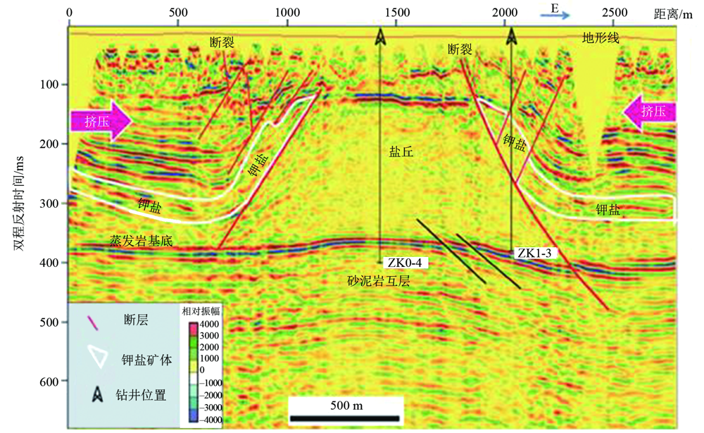
Fig.3 Pre-stack time migration section of 3D seismic line in a potash mining area in Laos. Modified after [24].

Fig.4 Measured shallow and speculated deep geological structural sections of the Dabie Mountain area. Modified after [13].
| 构造带(面)与地平面的关系 | 物探测线与构造带(面)的关系 | 分辨程度 | |||
|---|---|---|---|---|---|
| 重力剖面 | 磁法剖面 | 大深度电法剖面 | 地震剖面 | ||
| 平行 | 平行 | 低 | 低 | 较高 | 高 |
| 垂直 | 低 | 低 | 较高 | 高 | |
| 斜交 | 低 | 低 | 较高 | 高 | |
| 斜交 | 平行 | 无或较低 | 无或较低 | 无或较高 | 无或高 |
| 垂直 | 低 | 低 | 较高 | 高 | |
| 斜交 | 低 | 低 | 较高 | 高 | |
| 垂直 | 平行 | 无 | 无 | 无 | 无 |
| 垂直 | 较高 | 较高 | 高 | 高 | |
| 斜交 | 较高 | 较高 | 高 | 高 | |
Table 3 List of resolution levels of main geophysical prospecting methods for structural planes (belts) in different directions
| 构造带(面)与地平面的关系 | 物探测线与构造带(面)的关系 | 分辨程度 | |||
|---|---|---|---|---|---|
| 重力剖面 | 磁法剖面 | 大深度电法剖面 | 地震剖面 | ||
| 平行 | 平行 | 低 | 低 | 较高 | 高 |
| 垂直 | 低 | 低 | 较高 | 高 | |
| 斜交 | 低 | 低 | 较高 | 高 | |
| 斜交 | 平行 | 无或较低 | 无或较低 | 无或较高 | 无或高 |
| 垂直 | 低 | 低 | 较高 | 高 | |
| 斜交 | 低 | 低 | 较高 | 高 | |
| 垂直 | 平行 | 无 | 无 | 无 | 无 |
| 垂直 | 较高 | 较高 | 高 | 高 | |
| 斜交 | 较高 | 较高 | 高 | 高 | |
| 构造变形 岩相级别 | 典型实例 | 探区面积/km2 | 构造单 元级别 | 有利成矿 构造部位 | 有利构造变形 岩相目标 | 地球物理 异常特征 | 物探方法 组合 |
|---|---|---|---|---|---|---|---|
| 一级 | 中国东部主要成矿区带 | 几千至几万 | 三、四级 | 大规模构造-岩浆-流体活动区 | 伸展构造域 | 重力低、磁力低或负异常、断裂构造带 | 重磁勘探+三维地震+MT网络测量 |
| 二级 | 胶东西北部金成矿带和矿田 | 几十至几百 | 五级 | 岩浆核杂岩隆起-拆离构造发育的矿田 | 挤压-剪切-伸展构造 | 重力低、磁力低或负异常、断裂构造带 | 重磁勘探+三维地震或地震剖面 |
| 三级 | 招远—平度含金断裂带 | 几至十几 | 六级以下 | 岩体与围岩接触带的深部构造 | 张性-张剪性构造 | 断裂构造界面、低阻带 | 地震+MT剖面 |
Table 4 Classification scheme of three-level structural deformation lithofacies based on geophysical information (example of the Jiaodong area)
| 构造变形 岩相级别 | 典型实例 | 探区面积/km2 | 构造单 元级别 | 有利成矿 构造部位 | 有利构造变形 岩相目标 | 地球物理 异常特征 | 物探方法 组合 |
|---|---|---|---|---|---|---|---|
| 一级 | 中国东部主要成矿区带 | 几千至几万 | 三、四级 | 大规模构造-岩浆-流体活动区 | 伸展构造域 | 重力低、磁力低或负异常、断裂构造带 | 重磁勘探+三维地震+MT网络测量 |
| 二级 | 胶东西北部金成矿带和矿田 | 几十至几百 | 五级 | 岩浆核杂岩隆起-拆离构造发育的矿田 | 挤压-剪切-伸展构造 | 重力低、磁力低或负异常、断裂构造带 | 重磁勘探+三维地震或地震剖面 |
| 三级 | 招远—平度含金断裂带 | 几至十几 | 六级以下 | 岩体与围岩接触带的深部构造 | 张性-张剪性构造 | 断裂构造界面、低阻带 | 地震+MT剖面 |

Fig.5 Schematic geophysical and geochemical profiles of the Zhaoping fault zone and its footwall. Modified after [32].
| 地质作用 | 矿田一级类型 | 矿田规模 | 勘探目标 | 构造变形岩相目标 | 物探方法组合 | 实例 |
|---|---|---|---|---|---|---|
| 沉积作用 | 构造沉积岩相矿田 | 几十至几千km2 | 铁矿、固体钾盐矿、煤炭、石墨矿 | 隆起-凹陷过渡带 | 重力、三维地震、大深度电磁法 | 湖南宁乡、老挝中部、内蒙古鄂尔多斯、安徽两淮、陕西秦岭 |
| 岩浆作用 | 构造岩浆岩相矿田 | 几十至几百km2 | 钨、锡、钼、铁、铜矿 | 岩浆核杂岩隆起-拆离凹陷过渡带 | 重磁法、电磁法 | 江西赣南、云南个旧、安徽铜陵、湖北大冶 |
| 火山作用 | 构造火山岩相矿田 | 几十至几百km2 | 铀矿 | 岩浆核杂岩隆起-拆离凹陷过渡带 | 重磁法 | 江西相山 |
| 变质作用 | 构造变质岩相矿田 | 几十至几百km2 | BIF铁矿 | 褶皱构造和韧性剪切带 | 重磁法 | 河北冀东、辽宁鞍山 |
| 复成构造 热液作用 | 构造蚀变岩相矿田 | 几十至几百km2 | 玲珑-焦家复合型金矿 | 岩浆核杂岩隆起-拆离凹陷过渡带 | 重磁法、电磁法、地震 | 胶东玲珑、焦家、新城 |
Table 5 Classification scheme of tectonic deformation lithofacies of typical ore fields based on geophysical information
| 地质作用 | 矿田一级类型 | 矿田规模 | 勘探目标 | 构造变形岩相目标 | 物探方法组合 | 实例 |
|---|---|---|---|---|---|---|
| 沉积作用 | 构造沉积岩相矿田 | 几十至几千km2 | 铁矿、固体钾盐矿、煤炭、石墨矿 | 隆起-凹陷过渡带 | 重力、三维地震、大深度电磁法 | 湖南宁乡、老挝中部、内蒙古鄂尔多斯、安徽两淮、陕西秦岭 |
| 岩浆作用 | 构造岩浆岩相矿田 | 几十至几百km2 | 钨、锡、钼、铁、铜矿 | 岩浆核杂岩隆起-拆离凹陷过渡带 | 重磁法、电磁法 | 江西赣南、云南个旧、安徽铜陵、湖北大冶 |
| 火山作用 | 构造火山岩相矿田 | 几十至几百km2 | 铀矿 | 岩浆核杂岩隆起-拆离凹陷过渡带 | 重磁法 | 江西相山 |
| 变质作用 | 构造变质岩相矿田 | 几十至几百km2 | BIF铁矿 | 褶皱构造和韧性剪切带 | 重磁法 | 河北冀东、辽宁鞍山 |
| 复成构造 热液作用 | 构造蚀变岩相矿田 | 几十至几百km2 | 玲珑-焦家复合型金矿 | 岩浆核杂岩隆起-拆离凹陷过渡带 | 重磁法、电磁法、地震 | 胶东玲珑、焦家、新城 |
| 编号 | 矿床类型 | 构造变形岩相分带特征 | 矿体形态 | 物性异常带模型(平、剖面) | 实例 |
|---|---|---|---|---|---|
| 1 | 块状硫化物(VMS、MVT、SEDEX) | 中心块状硫化物,近矿低温绿泥石化带,向外绢云母硅化带,远矿石灰岩或火山岩 | 块状、层状、似层状 | 中心高密度-低阻-高极化,向两侧低阻-低密度-负磁异常,再向外低密度-高阻-低极化 | 埃塞俄比亚VMS、甘肃白银厂铜矿,美国密西西比河谷型、川滇黔地区铅锌矿,甘肃厂坝SEDEX型铅锌矿等[ |
| 2 | 斑岩型铜金、铜钼矿 | 中心强硅化-钾化带,向外依次为绢英岩化带、泥化带、青磐岩化带、中酸性火山岩 | 细脉状、浸染状 | 中心高阻-低极化-负磁异常,向外低阻-高极化,再向外高阻-低极化 | 产于不同构造环境下的斑岩型铜矿床(蒙古OT矿区、智利El Teniente矿区、西藏驱龙矿区、多不杂矿区、江西德兴矿区、新疆土屋矿区)[ |
| 3 | 浅成低温热液型金(铜银)多金属矿:(1)高硫石英-明矾石型;(2)低硫冰长石-绢云母型 | (1)中心硅化带,明矾石-重晶石化带,黏土化(地开石化)带;(2)中心黄铁绢英岩化带,绿泥石化带,碳酸盐化带,硅化带,黏土化带,冰长石化带 | 块状、似层状、细脉浸染状、角砾状 | (1)中心高阻-高极化-负磁,向外低阻-低极化; (2)中心低阻-高极化-负磁,向外高阻-低极化 | 福建紫金山、新疆阿希、西藏冈底斯 [ |
| 4 | 夕卡岩型铁铜多金属矿 | 自矿化中心向外,依次出现含矿夕卡岩带、绢云母化-钾化带、云英岩化带、绿泥石-绿帘石-钠黝帘石化带、硅化-大理岩化带 | 块状、脉状、透镜状、带状 | 中心低阻、高密度、正磁性,向外高阻、低密度、负磁性 | 大兴安岭中南段、湖北大冶、安徽铜官山[ |
| 5 | 蚀变岩-石英脉型金矿 | 中心向外为黄铁矿-石英脉带、黄铁绢英岩化带、强钾化蚀变带、弱钾化蚀变带、未蚀变花岗岩带 | 似层状、脉状 | 中心低阻-高极化-正磁,向外高阻-低极化-负磁 | 山东焦家-玲珑[ |
Table 6 List of physical properties of tectonic deformation lithofacies belts of typical metal deposit types
| 编号 | 矿床类型 | 构造变形岩相分带特征 | 矿体形态 | 物性异常带模型(平、剖面) | 实例 |
|---|---|---|---|---|---|
| 1 | 块状硫化物(VMS、MVT、SEDEX) | 中心块状硫化物,近矿低温绿泥石化带,向外绢云母硅化带,远矿石灰岩或火山岩 | 块状、层状、似层状 | 中心高密度-低阻-高极化,向两侧低阻-低密度-负磁异常,再向外低密度-高阻-低极化 | 埃塞俄比亚VMS、甘肃白银厂铜矿,美国密西西比河谷型、川滇黔地区铅锌矿,甘肃厂坝SEDEX型铅锌矿等[ |
| 2 | 斑岩型铜金、铜钼矿 | 中心强硅化-钾化带,向外依次为绢英岩化带、泥化带、青磐岩化带、中酸性火山岩 | 细脉状、浸染状 | 中心高阻-低极化-负磁异常,向外低阻-高极化,再向外高阻-低极化 | 产于不同构造环境下的斑岩型铜矿床(蒙古OT矿区、智利El Teniente矿区、西藏驱龙矿区、多不杂矿区、江西德兴矿区、新疆土屋矿区)[ |
| 3 | 浅成低温热液型金(铜银)多金属矿:(1)高硫石英-明矾石型;(2)低硫冰长石-绢云母型 | (1)中心硅化带,明矾石-重晶石化带,黏土化(地开石化)带;(2)中心黄铁绢英岩化带,绿泥石化带,碳酸盐化带,硅化带,黏土化带,冰长石化带 | 块状、似层状、细脉浸染状、角砾状 | (1)中心高阻-高极化-负磁,向外低阻-低极化; (2)中心低阻-高极化-负磁,向外高阻-低极化 | 福建紫金山、新疆阿希、西藏冈底斯 [ |
| 4 | 夕卡岩型铁铜多金属矿 | 自矿化中心向外,依次出现含矿夕卡岩带、绢云母化-钾化带、云英岩化带、绿泥石-绿帘石-钠黝帘石化带、硅化-大理岩化带 | 块状、脉状、透镜状、带状 | 中心低阻、高密度、正磁性,向外高阻、低密度、负磁性 | 大兴安岭中南段、湖北大冶、安徽铜官山[ |
| 5 | 蚀变岩-石英脉型金矿 | 中心向外为黄铁矿-石英脉带、黄铁绢英岩化带、强钾化蚀变带、弱钾化蚀变带、未蚀变花岗岩带 | 似层状、脉状 | 中心低阻-高极化-正磁,向外高阻-低极化-负磁 | 山东焦家-玲珑[ |
| 构造变形 岩相带 | 构造变形 岩相亚带 | 矿物组合 | 矿体(蚀变岩) 形态 | 电导率 | 磁化率 | 密度 | 矿致异常特征 | 物探方法组合 | |||||||
|---|---|---|---|---|---|---|---|---|---|---|---|---|---|---|---|
| 内带 | 块状硫化物 | 闪锌矿为主 | 层状 | 低 | 低 | 高 | 中等磁异常、 低电阻-高极 化率和高密度 | IP-重力-EM | |||||||
| 黄铁矿为主 | 层状 | 中 | 中-高 | 高 | |||||||||||
| 磁黄铁矿为主 | 层状 | 高 | 中-高 | 高 | |||||||||||
| 块状黄铁矿(含磁铁矿) | 柱状 | 中 | 高 | 高 | |||||||||||
| 块状磁铁矿 | 柱状 | 中 | 高 | 高 | |||||||||||
| 块状方铅矿 | 柱状 | 中 | 无 | 高 | |||||||||||
| 网脉状硫化物 | 磁黄铁矿 | 柱状 | 高 | 中 | 中 | 低电阻- 高极化率 | IP | ||||||||
| 黄铁矿 | 柱状 | 中 | 无 | 中 | |||||||||||
| 浸染状硫化物 | 黄铁矿或磁黄铁矿 | 柱状 | 低-中 | 低 | 低 | ||||||||||
| 粗粒黄铁矿 | 柱状 | 中 | 无 | 低 | |||||||||||
| 粗粒磁黄铁矿 | 柱状 | 中 | 中 | 低 | |||||||||||
| 燧石-硅化带 | 石英 | 层状-柱状 | 高 | 无 | 低 | 高电阻-低磁 化率-低密度 | IP-重力-EM | ||||||||
| 中带 | 绿泥石-硫化物蚀变带 | 石墨片理化带 | 层状 | 中-高 | 中-低 | 中-高 | 低电阻-高极 化率和较高密度 | IP-重力 | |||||||
| 绿泥石带 | 片理面上的石墨 | 层状 | 低 | 低 | 低 | ||||||||||
| 外带 | 酸性火山岩 | 硅酸盐矿物 | 层状-柱状 | 高 | 低 | 低 | 中高阻-低极化 率-低密度 | IP-重力-EM | |||||||
| 沉积岩 | 硅酸盐矿物 | 层状 | 中-高 | 低 | 低 | ||||||||||
Table 7 Tectonic lithofacies zonation and geophysical information of VMS type ore deposits (physical parameters from [34])
| 构造变形 岩相带 | 构造变形 岩相亚带 | 矿物组合 | 矿体(蚀变岩) 形态 | 电导率 | 磁化率 | 密度 | 矿致异常特征 | 物探方法组合 | |||||||
|---|---|---|---|---|---|---|---|---|---|---|---|---|---|---|---|
| 内带 | 块状硫化物 | 闪锌矿为主 | 层状 | 低 | 低 | 高 | 中等磁异常、 低电阻-高极 化率和高密度 | IP-重力-EM | |||||||
| 黄铁矿为主 | 层状 | 中 | 中-高 | 高 | |||||||||||
| 磁黄铁矿为主 | 层状 | 高 | 中-高 | 高 | |||||||||||
| 块状黄铁矿(含磁铁矿) | 柱状 | 中 | 高 | 高 | |||||||||||
| 块状磁铁矿 | 柱状 | 中 | 高 | 高 | |||||||||||
| 块状方铅矿 | 柱状 | 中 | 无 | 高 | |||||||||||
| 网脉状硫化物 | 磁黄铁矿 | 柱状 | 高 | 中 | 中 | 低电阻- 高极化率 | IP | ||||||||
| 黄铁矿 | 柱状 | 中 | 无 | 中 | |||||||||||
| 浸染状硫化物 | 黄铁矿或磁黄铁矿 | 柱状 | 低-中 | 低 | 低 | ||||||||||
| 粗粒黄铁矿 | 柱状 | 中 | 无 | 低 | |||||||||||
| 粗粒磁黄铁矿 | 柱状 | 中 | 中 | 低 | |||||||||||
| 燧石-硅化带 | 石英 | 层状-柱状 | 高 | 无 | 低 | 高电阻-低磁 化率-低密度 | IP-重力-EM | ||||||||
| 中带 | 绿泥石-硫化物蚀变带 | 石墨片理化带 | 层状 | 中-高 | 中-低 | 中-高 | 低电阻-高极 化率和较高密度 | IP-重力 | |||||||
| 绿泥石带 | 片理面上的石墨 | 层状 | 低 | 低 | 低 | ||||||||||
| 外带 | 酸性火山岩 | 硅酸盐矿物 | 层状-柱状 | 高 | 低 | 低 | 中高阻-低极化 率-低密度 | IP-重力-EM | |||||||
| 沉积岩 | 硅酸盐矿物 | 层状 | 中-高 | 低 | 低 | ||||||||||
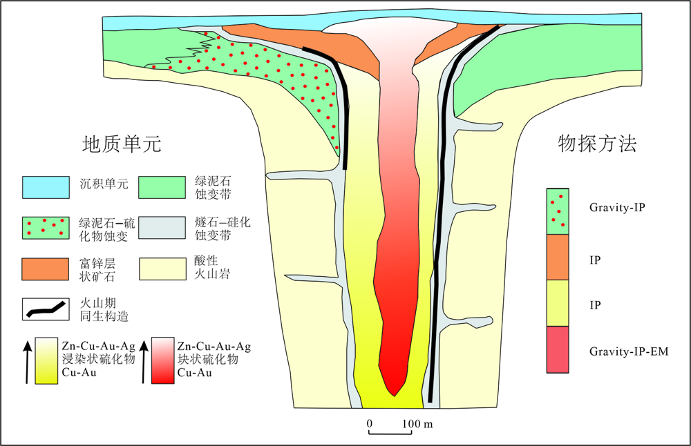
Fig.6 A geophysical exploration model of VMS deposit in Ethiopia. Modified after [34].
| [1] | 吕古贤. 胶东半岛构造-岩相形式及玲珑-焦家式金矿的构造动力成岩成矿地质特征研究[D]. 北京: 中国地质科学院, 1989: 1-164. |
| [2] | 吕古贤, 孔庆存. 胶东玲珑-焦家式金矿地质[M]. 北京: 科学出版社, 1993: 1-253. |
| [3] | 吕古贤, 邓军, 郭涛, 等. 玲珑-焦家式金矿构造变形岩相形迹大比例尺填图与构造成矿研究[J]. 地球学报, 1998, 19(2):177-186. |
| [4] | 吕古贤, 林文蔚, 罗元华, 等. 构造物理化学与金矿成矿预测[M]. 北京: 地质出版社, 1999: 1-400. |
| [5] | 吕古贤, 郭涛, 舒斌, 等. 构造变形岩相形迹的大比例尺填图及其对隐伏矿床地质预测: 以胶东玲珑-焦家式金矿为例[J]. 中国区域地质, 2001, 20(3):313-321. |
| [6] | 刘光鼎. 深部探测:诠释成矿过程、拓展深部资源[J]. 地球物理学报, 2015, 58(12):4317-4318. |
| [7] | 樊俊, 郭源阳, 成永生. 国家重点研发计划“深地资源勘查开采”攻关目标与任务剖析[J]. 中国地质, 2019, 46(4):919-926. |
| [8] | 张宝林, 苗雅娜, 苏艳平, 等. “地物化三场异常耦合理论”及其在隐伏金多金属矿床定位预测中的应用[J]. 黄金科学技术, 2018, 26(4):431-442. |
| [9] | 刘光鼎, 郝天珧, 刘伊克. 中国大地构造宏观格架及其与矿产资源的关系: 根据地球物理资料的认识[J]. 科学通报, 1997, 42(2):113-118. |
| [10] | 潘桂棠, 肖庆辉, 陆松年, 等. 中国大地构造单元划分[J]. 中国地质, 2009, 36(1):1-28. |
| [11] | 熊盛青, 杨海, 丁燕云, 等. 中国航磁大地构造单元划分[J]. 中国地质, 2018, 45(4):658-680. |
| [12] | 白武明. 地球动力学[M]. 北京: 地震出版社, 2003: 1-303. |
| [13] | 肖骑彬, 赵国泽, 詹艳, 等. 大别山超高压变质带深部电性结构及其动力学意义初步研究[J]. 地球物理学报, 2007, 50(3):812-822. |
| [14] | 印兴耀, 宗兆云, 吴国忱. 岩石物理驱动下地震流体识别研究[J]. 中国科学: 地球科学, 2015, 45(1):8-21. |
| [15] | 张明辉, 刘有山, 侯爵, 等. 近地表地震层析成像方法综述[J]. 地球物理学进展, 2019, 34(1):48-63. |
| [16] | 柳建新, 赵然, 郭振威. 电磁法在金属矿勘查中的研究进展[J]. 地球物理学进展, 2019, 34(1):151-160. |
| [17] | 张宝林, 苏艳平, 张国梁, 等. 胶东典型含矿构造岩相带的地质-地球物理信息预测方法与找矿实践[J]. 地学前缘, 2017, 24(2):85-94. |
| [18] | 张宝林, 吕古贤, 梁光河, 等. 胶东金矿田的深部地球物理勘查模式初步研究[J]. 地质力学学报, 2019, 25(增刊1):150-156. |
| [19] | 余佳. 地质力学矿田构造的进展与前景[J]. 地质与勘探, 2012, 48(1):102-109. |
| [20] | 马宗晋, 高祥林, 宋正范. 中国布格重力异常水平梯度图的判读和构造解释[J]. 地球物理学报, 2006, 49(1):106-114. |
| [21] | 中国地质科学院地质力学研究所. 1∶2500000中华人民共和国及其毗邻海区构造体系图简要说明书[M]. 北京: 地图出版社, 1984. |
| [22] | 国家地震局书名编委会. 中国岩石圈动力学地图集[CM]. 北京: 地图出版社, 1989. |
| [23] | 翟丽娜, 贾晓东, 孔祥瑞, 等. 郯庐断裂带中段三维密度结构反演与解释[J]. 地震学报, 2019, 41(4):472-483, 548. |
| [24] | 梁光河, 徐兴旺, 刘兴江, 等. 老挝万象盆地萨塔尼钾盐矿的构造变形与深部矿预测[J]. 大地构造与成矿学, 2019, 43(5):934-942. |
| [25] | 吕古贤. 矿田地质分类研究[J]. 地学前缘, 2015, 22(4):1-12. |
| [26] | 涂光炽. 祁连山的构造-岩相带[J]. 地质科学, 1959, 2(7):193-198. |
| [27] | 陈国达. 成矿构造研究法[M]. 2版. 北京: 地质出版社, 1985: 1-421. |
| [28] | 张文佑. 断块构造导论[M]. 北京: 石油工业出版社, 1984: 1-385. |
| [29] | 刘光鼎. 用科学发展观统率矿产资源工作[J]. 中国科学院院刊, 2006, 21(3):240-244. |
| [30] | 吕古贤, 李洪奎, 丁正江, 等. 胶东地区“岩浆核杂岩”隆起-拆离带岩浆期后热液蚀变成矿[J]. 现代地质, 2016, 30(2):247-262. |
| [31] | 何昌成. 玲珑金矿田岩浆核杂岩隆起-拆离成矿构造解析与预测[D]. 北京: 中国地质大学(北京), 2018: 1-92. |
| [32] | 徐述平. 招平断裂带金矿勘查模型与成矿预测[D]. 北京: 中国地质大学(北京), 2009: 1-186. |
| [33] | 吕古贤, 武际春, 朱随洲, 等. 矿田地质学的概念和构造岩相分类[J]. 地质论评, 2016, 62(增刊1):321-322. |
| [34] | 甘凤伟, 王京彬, 朱思才, 等. 埃塞俄比亚北部VMS型铜多金属矿快速勘查方法[J]. 矿产勘查, 2018, 9(8):1611-1621. |
| [35] | 彭素霞, 程建新, 余吉远, 等. 北祁连清水沟—白柳沟矿田块状硫化物矿床成矿特征及找矿方向[J]. 西北地质, 2013, 46(4):142-150. |
| [36] | 申屠良义, 韩润生, 李波, 等. 密西西比河谷型(MVT)铅锌矿床蚀变特征及研究展望[J]. 地球科学与环境学报, 2010, 32(增刊):142-144. |
| [37] | 罗俊杰, 张建芳. Sedex型矿床地质特征及成矿物质来源示踪[J]. 资源环境与工程, 2010, 24(1):36-40. |
| [38] | 李莎莎, 陈华勇, 汪礼明. 关于建立斑岩型铜矿床勘查标识体系的初步探讨[J]. 大地构造与成矿学, 2019, 43(5):991-1009. |
| [39] | 姚佛军. 中国典型斑岩铜矿遥感蚀变分带模型研究[D]. 北京: 中国地质大学(北京), 2012: 1-263. |
| [40] | 郭玉乾, 方维萱, 刘家军. 浅成低温热液金银多金属矿床矿化分带及找矿标志[J]. 矿产与地质, 2009, 23(1):7-14. |
| [41] | 郭娜, 郭文铂, 刘栋, 等. 冈底斯成矿带陆相火山岩区浅成低温热液矿床蚀变分带模型: 以西藏斯弄多矿床为例[J]. 岩石学报, 2019, 35(3):833-848. |
| [42] | 杜青松, 李志华, 鄂阿强, 等. 大兴安岭中南段夕卡岩型铅锌矿床地质特征及成因[J]. 矿产勘查, 2017, 8(3):366-373. |
| [43] | 张叔贞, 林新多, 姚书振. 湖北张福山矿浆-热液过渡型矽卡岩铁矿蚀变矿化分带[J]. 地球科学: 中国地质大学学报, 1985, 10(4):45-51. |
| [44] | 崔彬. 铜官山层控矽卡岩型铜矿床的蚀变分带及其成因[J]. 矿床地质, 1987, 6(1):35-44. |
| [45] | 范潇, 吕古贤, 王宗永, 等. 焦家金矿田构造蚀变岩填图及其地球化学特征分析[J]. 地学前缘, 2015, 22(4):46-52. |
| [46] | 周国发. 玲珑金矿田构造蚀变岩带及找矿预测研究[D]. 北京: 中国地质大学(北京), 2009: 1-113. |
| [47] | 未晛, 杨志芳, 晏信飞. 地震勘探中的多尺度问题及其研究进展[J]. 地球物理学进展, 2019, 34(6):2353-2360. |
| Viewed | ||||||
|
Full text |
|
|||||
|
Abstract |
|
|||||