Earth Science Frontiers ›› 2025, Vol. 32 ›› Issue (5): 546-556.DOI: 10.13745/j.esf.sf.2024.12.2
DI Yong1( ), WEI Yunjie2, TAN Weijia1, XU Qiang1,*()
Received:2024-09-02
Revised:2024-12-05
Online:2025-09-25
Published:2025-10-14
Contact:
XU Qiang
CLC Number:
DI Yong, WEI Yunjie, TAN Weijia, XU Qiang. Risk assessment of landslide-induced river blockage based on RAMMS[J]. Earth Science Frontiers, 2025, 32(5): 546-556.

Fig.1 Geographical location of the landslide area
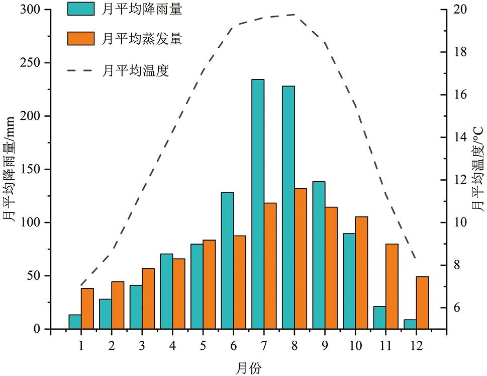
Fig.2 Rainfall map of the landslide area in 2021

Fig.3 Seismic intensity map of the landslide area

Fig.4 Orthophoto of the landslide on the pressure plate

Fig.5 Slope toe at the front edge of landslide
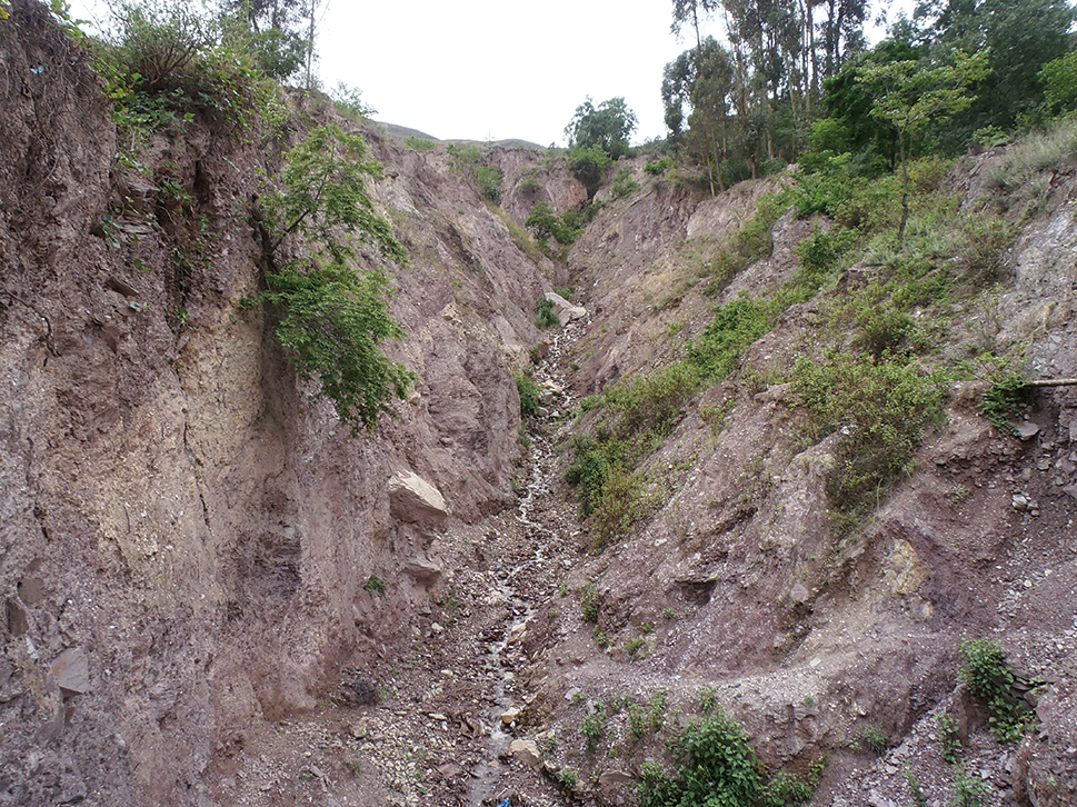
Fig.6 Characteristics of the rock and soil mass in the landslide
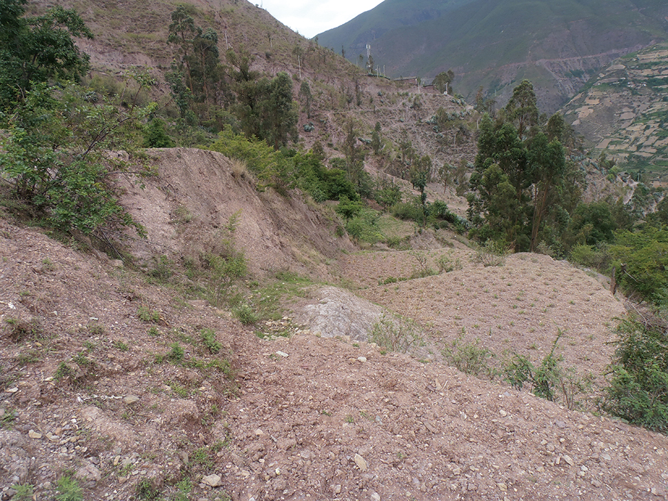
Fig.7 Farmland above the landslide
| 参数 | a | n | m | Mv | Sat.wc |
|---|---|---|---|---|---|
| 数值 | 46 kPa | 2.2 | 2 | 1×10⁻⁵ | 0.36 |
Table 1 Parameters of the Frehmd-Xing Model
| 参数 | a | n | m | Mv | Sat.wc |
|---|---|---|---|---|---|
| 数值 | 46 kPa | 2.2 | 2 | 1×10⁻⁵ | 0.36 |
| 参数 | 天然重度/(kN·m-3) | 饱和重度/(kN·m-3) | 黏聚力/kPa | 内摩擦角/(°) | 渗透系数/(mm·s-1) |
|---|---|---|---|---|---|
| 滑体 | 21 | 23 | 12 | 22 | 2×10⁻⁶ |
| 基岩 | 25 | — | 800 | 50 | 1×10⁻⁸ |
Table 2 Calculation parameters of landslide
| 参数 | 天然重度/(kN·m-3) | 饱和重度/(kN·m-3) | 黏聚力/kPa | 内摩擦角/(°) | 渗透系数/(mm·s-1) |
|---|---|---|---|---|---|
| 滑体 | 21 | 23 | 12 | 22 | 2×10⁻⁶ |
| 基岩 | 25 | — | 800 | 50 | 1×10⁻⁸ |
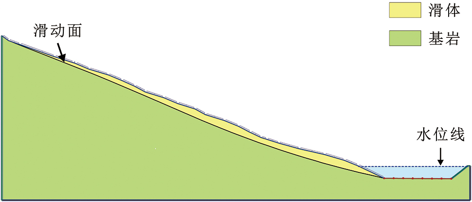
Fig.8 GeoStudio software computation model
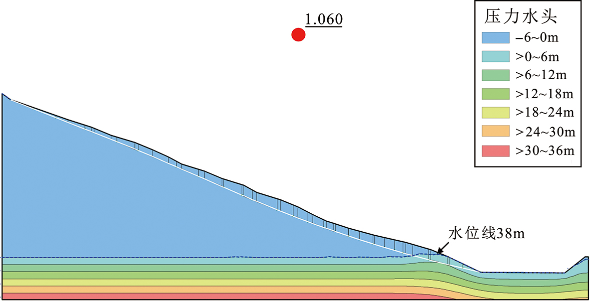
Fig.9 Stability coefficient under heavy rain conditions of 40 mm/d
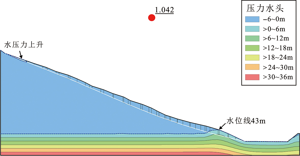
Fig.10 Stability coefficient under the extreme rainstorm condition of 120 mm/d

Fig.11 Comparison map before and after filtering the point cloud

Fig.12 Establishment of RAMMS Numerical Model
| 参数 | DEM分 辨率/m | 释放区 深度/m | 释放区 体积/m3 | 摩擦 系数μ | 湍流系数 ξ/s2 | 滑坡体密度/ (kg·m-3) | 模拟结束 时间/s | 动量 百分比/% | 转储步 时间/s |
|---|---|---|---|---|---|---|---|---|---|
| 数值 | 5 | 12 | 7 638 200 | 0.12 | 250 | 2 000 | 1 000 | 10 | 5 |
Table 3 RAMMS software calculation parameters
| 参数 | DEM分 辨率/m | 释放区 深度/m | 释放区 体积/m3 | 摩擦 系数μ | 湍流系数 ξ/s2 | 滑坡体密度/ (kg·m-3) | 模拟结束 时间/s | 动量 百分比/% | 转储步 时间/s |
|---|---|---|---|---|---|---|---|---|---|
| 数值 | 5 | 12 | 7 638 200 | 0.12 | 250 | 2 000 | 1 000 | 10 | 5 |

Fig.13 Movement height-time diagram of the landslide accumulation body on the pressure plate

Fig.14 Velocity-time diagram of the landslide accumulation body on the pressure plate

Fig.15 Proportion of accumulation bodies in different areas of the landslide on the pressure plate
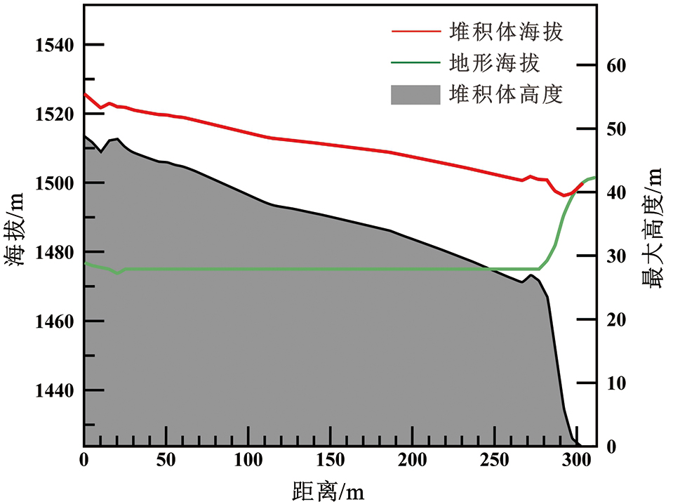
Fig.16 Cross-section of the accumulation body in the river
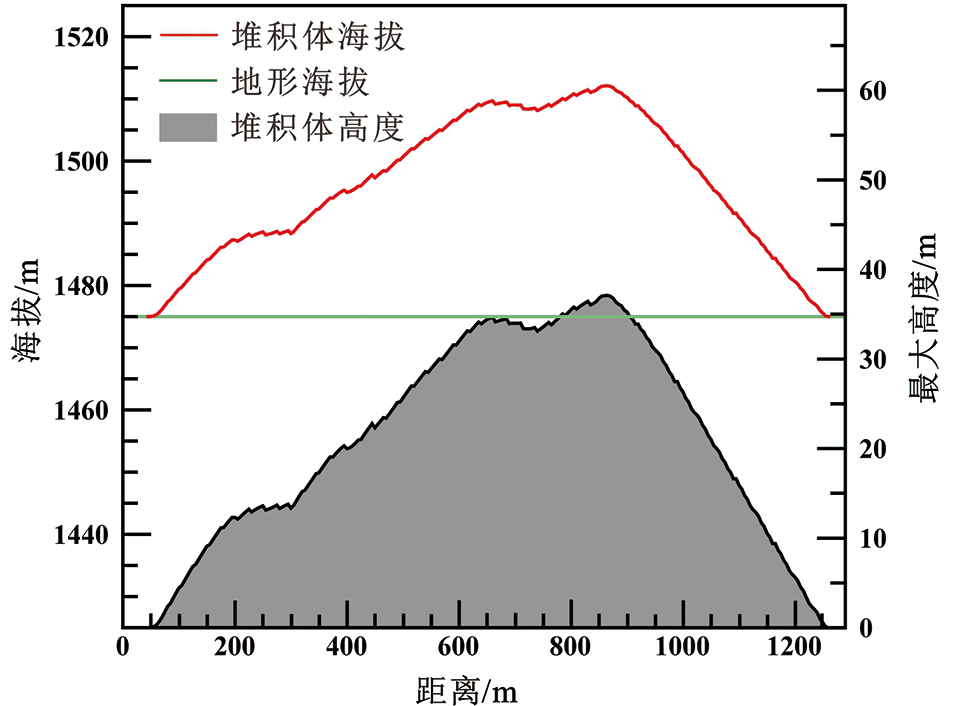
Fig.17 Profile of the accumulation body in the river

Fig.18 Velocity-time map of landslide into the river
| [1] | 韩旭东. 晚更新世曲龙滑坡堵江事件分析及堵江运动特征数值模拟研究[D]. 长春: 吉林大学, 2018. |
| [2] | 李永超. 金沙江上游苏洼龙河段早期滑坡堵江事件识别及演化研究[D]. 长春: 吉林大学, 2021. |
| [3] | 刘传正, 吕杰堂, 童立强, 等. 雅鲁藏布江色东普沟崩滑-碎屑流堵江灾害初步研究[J]. 中国地质, 2019, 46(2): 219-234. |
| [4] | 许强, 郑光, 李为乐, 等. 2018年10月和11月金沙江白格两次滑坡-堰塞堵江事件分析研究[J]. 工程地质学报, 2018, 26(6): 1534-1551. |
| [5] | 邓建辉, 高云建, 余志球, 等. 堰塞金沙江上游的白格滑坡形成机制与过程分析[J]. 工程科学与技术, 2019, 51(1): 9-16. |
| [6] | 胡卸文, 黄润秋, 施裕兵, 等. 唐家山滑坡堵江机制及堰塞坝溃坝模式分析[J]. 岩石力学与工程学报, 2009, 28(1): 181-189. |
| [7] | 王家柱, 任光明, 葛华. 金沙江上游某特大型滑坡发育特征及堵江机制[J]. 长江科学院院报, 2019, 36(2): 46-51, 57. |
| [8] | 高云建, 赵思远, 邓建辉. 青藏高原三江并流区重大堵江滑坡孕育规律及其防灾挑战[J]. 工程科学与技术, 2020, 52(5): 50-61. |
| [9] | PENG M, ZHANG L M. Breaching parameters of landslide dams[J]. Landslides, 2012, 9(1): 13-31. |
| [10] | FAN X M, DUFRESNE A, SIVA SUBRAMANIAN S, et al. The formation and impact of landslide dams-State of the art[J]. Earth-Science Reviews, 2020, 203: 103116. |
| [11] | 周礼, 范宣梅, 许强, 等. 金沙江白格滑坡运动过程特征数值模拟与危险性预测研究[J]. 工程地质学报, 2019, 27(6): 1395-1404. |
| [12] | 徐文杰, 陈祖煜, 何秉顺, 等. 肖家桥滑坡堵江机制及灾害链效应研究[J]. 岩石力学与工程学报, 2010, 29(5): 933-942. |
| [13] | 樊晓一, 黄润秋, 乔建平, 等. 未受河流阻止的滑坡水平运动距离与滑坡堵江判别[J]. 水文地质工程地质, 2014, 41(1): 128-133. |
| [14] | 王珊珊, 童立强, 郭兆成, 等. 基于河长: 坡降指数的滑坡堵江事件自动识别[J]. 工程地质学报, 2017, 25(2): 511-519. |
| [15] | 陈语, 李天斌, 魏永幸, 等. 沟谷型滑坡灾害链成灾机制及堵江危险性判别方法[J]. 岩石力学与工程学报, 2016, 35(增刊2): 4073-4081. |
| [16] | VAN WESTEN C J, CASTELLANOS E, KURIAKOSE S L. Spatial data for landslide susceptibility, hazard, and vulnerability assessment: an overview[J]. Engineering Geology, 2008, 102(3/4): 112-131. |
| [17] | 刘文, 王猛, 朱赛楠, 等. 基于光学遥感技术的高山极高山区高位地质灾害链式特征分析: 以金沙江上游典型堵江滑坡为例[J]. 中国地质灾害与防治学报, 2021, 32(5): 29-39. |
| [18] | 陆会燕, 李为乐, 许强, 等. 光学遥感与InSAR结合的金沙江白格滑坡上下游滑坡隐患早期识别[J]. 武汉大学学报(信息科学版), 2019, 44(9): 1342-1354. |
| [19] | 蔡耀军, 徐复兴, 朱萌, 等. 金沙江白格滑坡残留体失稳堵江风险分析[J]. 工程科学与技术, 2021, 53(6): 33-42. |
| [20] | 李高, 谭建民, 王世梅, 等. 滑坡对降雨响应的多指标监测及综合预警探析: 以赣南罗坳滑坡为例[J]. 地学前缘, 2021, 28(6): 283-294. |
| [21] | 殷志强, 魏刚, 秦小光, 等. 青藏高原东北缘黄河上游滑坡与堰塞湖研究进展[J]. 地学前缘, 2021, 28(2): 46-57. |
| [22] | 魏云杰, 王俊豪, 胡爱国, 等. 澜沧江拉金神谷滑坡成灾机理分析[J]. 中国地质调查, 2022, 9(4): 19-26. |
| [23] | 郭方琴. 降雨与水位升降对边坡稳定性影响分析[D]. 南昌: 南昌大学, 2018. |
| [24] | 马茜. 降雨和水位变化对库岸边坡稳定性影响的数值模拟研究[D]. 南京: 南京大学, 2015. |
| [25] | 温丽旺. 云南省云龙县果郎沟泥石流危险性评价研究[D]. 成都: 成都理工大学, 2018. |
| [26] | 鹿守山. 尾矿库漫顶溃坝模型试验及数值模拟[D]. 南昌: 南昌工程学院, 2019. |
| [27] | 费建波, 介玉新, 张丙印, 等. 颗粒流底部摩擦模型在高速远程滑坡模拟中的运用[J]. 水力发电学报, 2016, 35(1): 104-109. |
| [28] | SALM B. Flow, flow transition and runout distances of flowing avalanches[J]. Annals of Glaciology, 1993, 18: 221-226. |
| [29] | HUNGR O. A model for the runout analysis of rapid flow slides, debris flows, and avalanches[J]. Canadian Geotechnical Journal, 1995, 32(4): 610-623. |
| [30] | HUNGR O, MCDOUGALL S. Two numerical models for landslide dynamic analysis[J]. Computers and Geosciences, 2009, 35(5): 978-992. |
| [31] | DI Y, WEI Y J, TAN W J, et al. Research on development characteristics and landslide dam hazard prediction of Zhuangfang landslide in the upper reaches of the Nu river[J]. Sustainability, 2023, 15(20): 15036. |
| [32] | 张宏蓉, 杜娟, 殷坤龙, 等. 基于DAN-3D模型的滑坡运动特性模拟研究[J]. 甘肃科学学报, 2021, 33(6): 103-108. |
| [33] | 郑鸿超, 石振明, 彭铭, 等. 崩滑碎屑体堵江成坝研究综述与展望[J]. 工程科学与技术, 2020, 52(2): 19-28. |
| [1] | ZHAO Hu, GUO Feng, ZHAN Nan, LIU Siwen, JING Zhangwei, YUAN Hongfei, YU Tingting, ZHANG Xin, ZHU Yun, WANG Lei. Characteristics of mineral element distribution, geological origins, and health risk assessment of loquat fruits from Dongshan and Xishan of Suzhou [J]. Earth Science Frontiers, 2025, 32(4): 363-375. |
| [2] | HUANG Yi, DONG Xuan, MA Zhiyuan, TIAN Xizhao, ZHU Shuai, ZHU Yun. Rapid detection and risk assessment of endocrine disrupting chemicals in typical urban waters in northern cities of China [J]. Earth Science Frontiers, 2025, 32(4): 353-362. |
| [3] | MA Jianhua, LIU Jinfeng, ZHOU Yongzhang, ZHENG Yijun, LU Kefei, LIN Xingyu, WANG Hanyu, ZHANG Can. Online monitoring of CO2 using IoT for assessment of leakage risks associated with geological sequestration [J]. Earth Science Frontiers, 2024, 31(4): 139-146. |
| [4] | DONG Xin, HU Haoran, ZHANG Xiaoqing, REN Dajun, ZHANG Shuqin. A Meta-analysis of the distribution characteristics and ecological risk of heavy metals in mining areas [J]. Earth Science Frontiers, 2024, 31(2): 93-102. |
| [5] | GUO Xuehui, HUANG Renliang, WAN Jianhua. Heavy metal pollution in agricultural land around a tailings pond, northern Hubei and ecological and human health risk assessment [J]. Earth Science Frontiers, 2024, 31(2): 77-92. |
| [6] | WANG Xiaoyu, QU Yajing, ZHAO Wenhao, MA Jin. Soil screening levels in the United States and implication for soil evaluation in China [J]. Earth Science Frontiers, 2024, 31(2): 64-76. |
| [7] | HAO Mengqiuyue, LIU Daqing, YAN Zhenfei, FENG Chenglian. Short chain chlorinated paraffins in soil: Environmental safety criteria based on ecological risks [J]. Earth Science Frontiers, 2024, 31(2): 54-63. |
| [8] | DING Xiang, YUAN Bei, DU Ping, LIU Hupeng, ZHANG Yunhui, CHEN Juan. Heavy metal accumulation in soils of a typical mining community: Driving factors and probabilistic health risk assessment [J]. Earth Science Frontiers, 2024, 31(2): 31-41. |
| [9] | ZHANG Guanglu, LIU Haiyan, GUO Huaming, SUN Zhanxue, WANG Zhen, WU Tonghang. Occurrences and health risks of high-nitrate groundwater in typical piedmont areas of the North China Plain [J]. Earth Science Frontiers, 2023, 30(4): 485-503. |
| [10] | CAO Wei, ZHANG Lei, QIN Yanwen, CHI Minghui, ZHAO Yanmin, YANG Chenchen, SHI Yao. Spatial distribution characteristics and risk assessment of heavy metals in surface sediments in Lake Yunmeng [J]. Earth Science Frontiers, 2021, 28(5): 448-455. |
| [11] | FAN Xuanmei, DAI Lanxin, ZHONG Yujin, LI Jingjuan, WANG Lansheng. Recent research on the Diexi paleo-landslide: dam and lacustrine deposits upstream of the Minjiang River, Sichuan, China [J]. Earth Science Frontiers, 2021, 28(2): 71-84. |
| [12] | LI Haiyan,WANG Yaosen,ZHANG Xiaoran,YAN Lei,WU Liyuan,JIN Yi, CUI Ru,YANG Zhichao. Pollution load and health risk assessment of heavy metals in road-deposited sediment in the urban-rural fringe of Beijing [J]. Earth Science Frontiers, 2019, 26(6): 199-206. |
| [13] | Liu-Chang-Zheng, CHEN Yue-Long, HU Guang, DIAO Juan, LI Yue, LI Lin-Ye, JI Bing-Yan, HONG Yuan-Kui. Some problems in the study of the genesis of Xigeda Formation. [J]. Earth Science Frontiers, 2011, 18(5): 271-282. |
| [14] | XU Ze-Min, LIU Wen-Lian. Some problems in the study of the genesis of Xigeda Formation. [J]. Earth Science Frontiers, 2011, 18(5): 256-270. |
| [15] | JIN Li-Xin HOU Jing-Xie YANG Zhong-Fang BAO Yu-Han LI Zhong-Hui XU Zhou CHEN De-You. Environmental Health Risk Assessment of heavy metals in argoecosystems of Deyang district, Sichuan Province. [J]. Earth Science Frontiers, 2008, 15(5): 47-56. |
| Viewed | ||||||
|
Full text |
|
|||||
|
Abstract |
|
|||||