Earth Science Frontiers ›› 2025, Vol. 32 ›› Issue (5): 534-545.DOI: 10.13745/j.esf.sf.2025.3.75
Previous Articles Next Articles
HU Ziyue( ), ZHANG Runxin, MA Yue, PENG Nian*()
Received:2025-03-21
Revised:2025-03-30
Online:2025-09-25
Published:2025-10-14
Contact:
PENG Nian
CLC Number:
HU Ziyue, ZHANG Runxin, MA Yue, PENG Nian. Fractal dimension of the Dongting Lake drainage network based on DEM and its relationship with geological hazards[J]. Earth Science Frontiers, 2025, 32(5): 534-545.

Fig.1 Diagram of the water system of the whole basin of Dongting Lake
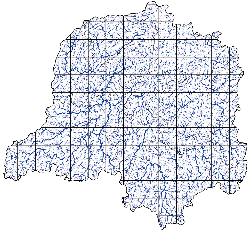
Fig.2 Watershed grid chart
| 分辨率 | 网格数/个 | log(box size) | log(count) |
|---|---|---|---|
| C2 | 658 686 | 0.693 15 | 13.432 42 |
| C3 | 331 811 | 0.728 15 | 13.374 57 |
| C4 | 207 803 | 0.763 16 | 13.316 72 |
| C6 | 109 883 | 0.798 17 | 13.258 87 |
| C8 | 71 019 | 0.833 18 | 13.201 02 |
| C12 | 38 602 | 0.868 18 | 13.143 18 |
| C16 | 24 817 | 0.903 19 | 13.085 33 |
| C32 | 7 324 | 0.938 20 | 13.027 48 |
| C64 | 1 906 | 0.973 21 | 12.969 63 |
Table 1 Number of grids, grid side lengths, and logarithmic values of the whole Dongting Lake basin
| 分辨率 | 网格数/个 | log(box size) | log(count) |
|---|---|---|---|
| C2 | 658 686 | 0.693 15 | 13.432 42 |
| C3 | 331 811 | 0.728 15 | 13.374 57 |
| C4 | 207 803 | 0.763 16 | 13.316 72 |
| C6 | 109 883 | 0.798 17 | 13.258 87 |
| C8 | 71 019 | 0.833 18 | 13.201 02 |
| C12 | 38 602 | 0.868 18 | 13.143 18 |
| C16 | 24 817 | 0.903 19 | 13.085 33 |
| C32 | 7 324 | 0.938 20 | 13.027 48 |
| C64 | 1 906 | 0.973 21 | 12.969 63 |
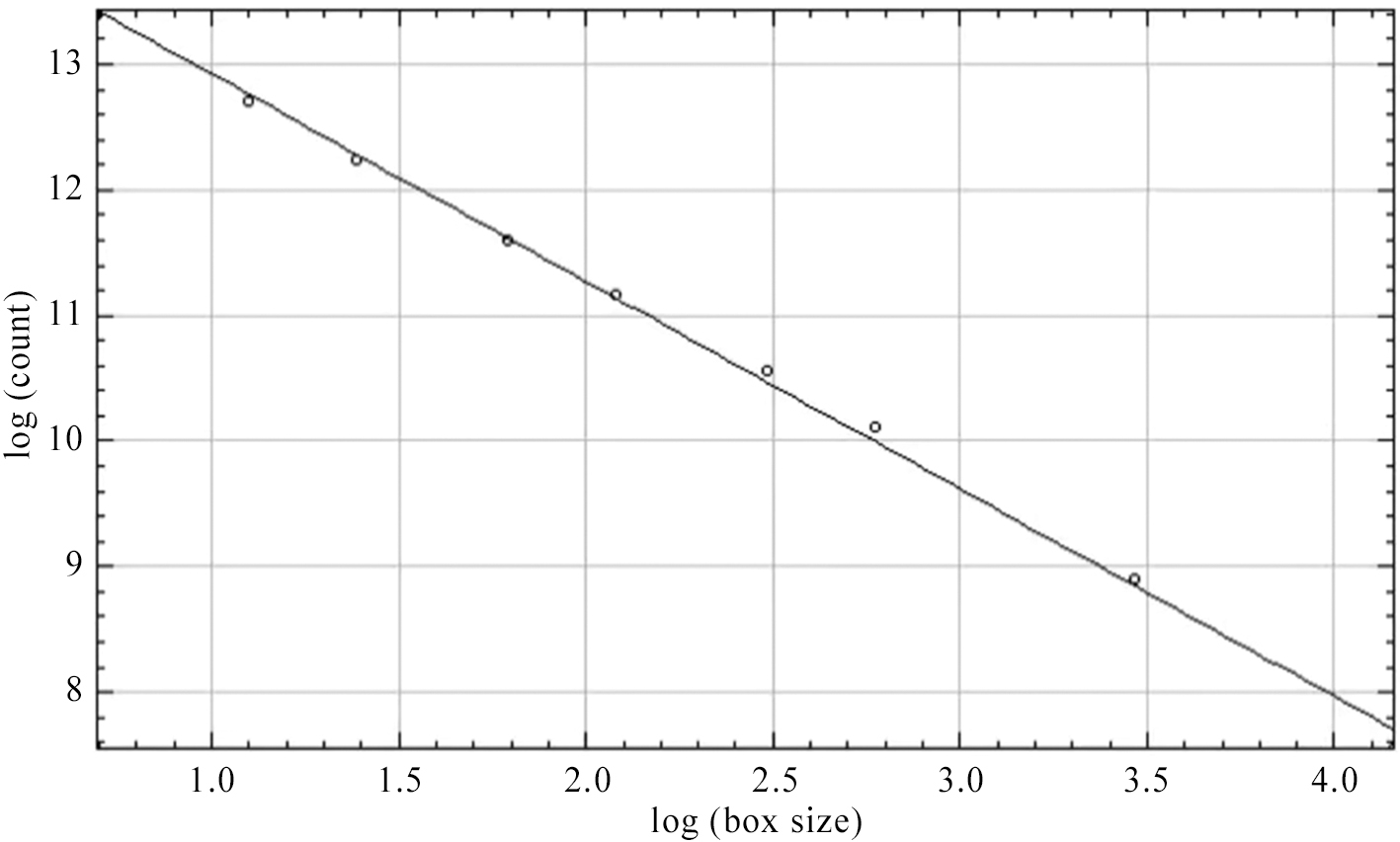
Fig.3 Fractal dimension fitting curve of the whole basin of Dongting Lake (fractal dimension value D≈1.653)

Fig.4 The water system of the Dongting Lake
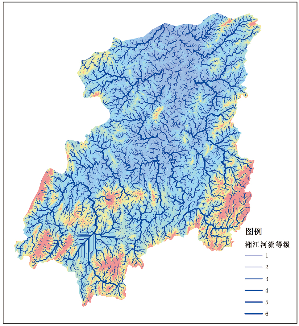
Fig.5 The water system of the Xiangjiang Basin
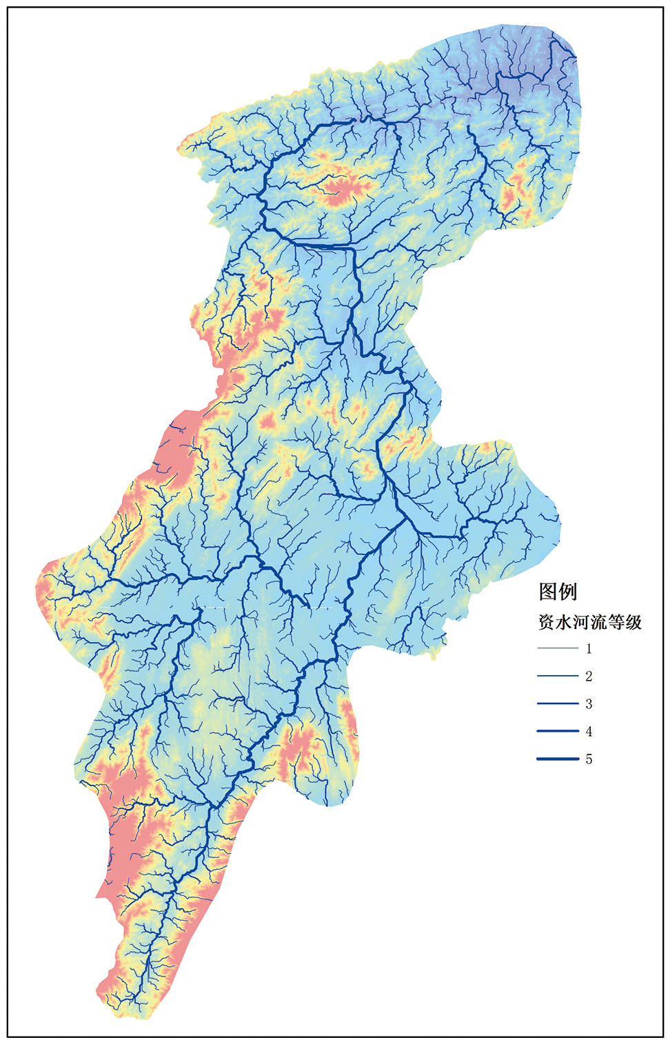
Fig.6 The water system of the Zishui Basin

Fig.7 The water system of the Lishui Basin

Fig.8 The water system of the Yuanjiang Basin
| 流域 | 分形维数值 | 灾害点总数量/个 | 面积/km2 | 占比(灾害点/面积)/% |
|---|---|---|---|---|
| 洞庭湖环湖区 | 1.621 | 344 | 33 726 | 1.0 |
| 湘江 | 1.743 | 2 308 | 94 237 | 2.4 |
| 资水 | 1.641 | 773 | 25 746 | 3.0 |
| 澧水 | 1.630 | 741 | 17 921 | 4.1 |
| 沅江 | 1.746 | 1 363 | 55 104 | 2.5 |
Table 2 Fractal dimension and number of disaster points in each basin of Dongting Lake
| 流域 | 分形维数值 | 灾害点总数量/个 | 面积/km2 | 占比(灾害点/面积)/% |
|---|---|---|---|---|
| 洞庭湖环湖区 | 1.621 | 344 | 33 726 | 1.0 |
| 湘江 | 1.743 | 2 308 | 94 237 | 2.4 |
| 资水 | 1.641 | 773 | 25 746 | 3.0 |
| 澧水 | 1.630 | 741 | 17 921 | 4.1 |
| 沅江 | 1.746 | 1 363 | 55 104 | 2.5 |
| 方格编号 | 分形维数值 | 灾害点密度/(个·2 500 km-2) | |
|---|---|---|---|
| 0 | 1.438 | 0 | |
| 1 | 1.496 | 3 | |
| 2 | 1.545 | 0 | |
| 3 | 1.267 | 0 | |
| 4 | 1.612 | 0 | |
| 5 | 1.583 | 5 | |
| 6 | 1.663 | 7 | |
| 7 | 1.528 | 1 | |
| 8 | 0.000 | 0 | |
| 9 | 0.000 | 0 | |
| 10 | 0.000 | 0 | |
| … | … | … | |
| 137 | 0.000 | 0 | |
| 皮尔逊相关性:r = 0.236(存在正相关关系) | |||
| 显著性:p = 0.006(在99%置信水平下, 该相关性是显著的) | |||
| 个案数:133个(有效样本数为133个) | |||
Table 3 Correlation between fractal dimension value and disaster point density
| 方格编号 | 分形维数值 | 灾害点密度/(个·2 500 km-2) | |
|---|---|---|---|
| 0 | 1.438 | 0 | |
| 1 | 1.496 | 3 | |
| 2 | 1.545 | 0 | |
| 3 | 1.267 | 0 | |
| 4 | 1.612 | 0 | |
| 5 | 1.583 | 5 | |
| 6 | 1.663 | 7 | |
| 7 | 1.528 | 1 | |
| 8 | 0.000 | 0 | |
| 9 | 0.000 | 0 | |
| 10 | 0.000 | 0 | |
| … | … | … | |
| 137 | 0.000 | 0 | |
| 皮尔逊相关性:r = 0.236(存在正相关关系) | |||
| 显著性:p = 0.006(在99%置信水平下, 该相关性是显著的) | |||
| 个案数:133个(有效样本数为133个) | |||
| 方格编号 | 分形维数值 | 灾害点密度/ (个·2 500 km-2) | 方格编号 | 分形维数值 | 灾害点密度/ (个·2 500 km-2) | 方格编号 | 分形维数值 | 灾害点密度/ (个·2 500 km-2) |
|---|---|---|---|---|---|---|---|---|
| 0 | 1.438 | 0 | 46 | 1.642 | 70 | 92 | 1.655 | 85 |
| 1 | 1.496 | 3 | 47 | 1.609 | 92 | 93 | 1.591 | 88 |
| 2 | 1.545 | 0 | 48 | 1.550 | 1 | 94 | 1.663 | 105 |
| 3 | 1.267 | 0 | 49 | 1.567 | 0 | 95 | 1.647 | 39 |
| 4 | 1.612 | 0 | 50 | 1.666 | 0 | 96 | 1.666 | 13 |
| 5 | 1.583 | 5 | 51 | 1.655 | 0 | 97 | 1.574 | 53 |
| 6 | 1.663 | 7 | 52 | 1.695 | 0 | 98 | 1.633 | 14 |
| 7 | 1.528 | 1 | 53 | 1.675 | 28 | 99 | 1.686 | 12 |
| 8 | 0.000 | 0 | 54 | 1.658 | 51 | 100 | 1.660 | 63 |
| 9 | 0.000 | 0 | 55 | 1.672 | 68 | 101 | 1.710 | 66 |
| 10 | 0.000 | 0 | 56 | 1.624 | 39 | 102 | 1.663 | 122 |
| 11 | 1.182 | 0 | 57 | 1.630 | 28 | 103 | 1.613 | 53 |
| 12 | 1.621 | 0 | 58 | 1.673 | 112 | 104 | 1.646 | 77 |
| 13 | 1.663 | 6 | 59 | 1.670 | 39 | 105 | 1.677 | 26 |
| 14 | 1.715 | 29 | 60 | 1.698 | 55 | 106 | 1.601 | 4 |
| 15 | 1.653 | 33 | 61 | 1.541 | 128 | 107 | 1.663 | 30 |
| 16 | 1.613 | 21 | 62 | 1.518 | 101 | 108 | 1.545 | 38 |
| 17 | 1.578 | 49 | 63 | 1.689 | 0 | 109 | 1.636 | 27 |
| 18 | 1.540 | 52 | 64 | 1.680 | 0 | 110 | 1.614 | 1 |
| 19 | 1.577 | 0 | 65 | 1.665 | 7 | 111 | 1.669 | 102 |
| 20 | 1.570 | 0 | 66 | 1.645 | 41 | 112 | 1.636 | 177 |
| 21 | 1.515 | 0 | 67 | 1.612 | 181 | 113 | 1.660 | 198 |
| 22 | 1.594 | 0 | 68 | 1.688 | 128 | 114 | 1.591 | 42 |
| 23 | 1.657 | 19 | 69 | 1.669 | 127 | 115 | 1.567 | 33 |
| 24 | 1.549 | 14 | 70 | 1.647 | 105 | 116 | 1.598 | 8 |
| 25 | 1.580 | 19 | 71 | 1.643 | 94 | 117 | 1.634 | 4 |
| 26 | 1.644 | 8 | 72 | 1.663 | 62 | 118 | 1.567 | 17 |
| 27 | 1.679 | 39 | 73 | 1.352 | 60 | 119 | 1.543 | 55 |
| 28 | 1.661 | 54 | 74 | 1.413 | 28 | 120 | 1.392 | 5 |
| 29 | 1.658 | 56 | 75 | 1.657 | 0 | 121 | 1.618 | 0 |
| 30 | 1.695 | 46 | 76 | 1.677 | 0 | 122 | 1.660 | 2 |
| 31 | 1.681 | 43 | 77 | 1.694 | 41 | 123 | 1.667 | 34 |
| 32 | 1.631 | 98 | 78 | 1.710 | 26 | 124 | 1.681 | 99 |
| 33 | 0.000 | 0 | 79 | 1.670 | 46 | 125 | 1.681 | 84 |
| 34 | 1.628 | 0 | 80 | 1.671 | 64 | 126 | 1.583 | 64 |
| 35 | 1.670 | 0 | 81 | 1.672 | 103 | 127 | 1.584 | 10 |
| 36 | 1.673 | 0 | 82 | 1.653 | 118 | 128 | 1.580 | 10 |
| 37 | 1.662 | 0 | 83 | 1.614 | 135 | 129 | 1.509 | 8 |
| 38 | 1.657 | 29 | 84 | 1.678 | 32 | 130 | 1.400 | 19 |
| 39 | 1.660 | 78 | 85 | 1.571 | 23 | 131 | 1.561 | 0 |
| 40 | 1.648 | 49 | 86 | 1.268 | 0 | 132 | 1.599 | 0 |
| 41 | 1.658 | 71 | 87 | 1.637 | 0 | 133 | 1.518 | 19 |
| 42 | 1.685 | 65 | 88 | 1.671 | 0 | 134 | 1.567 | 18 |
| 43 | 1.647 | 72 | 89 | 1.715 | 37 | 135 | 1.366 | 0 |
| 44 | 1.699 | 104 | 90 | 1.647 | 83 | 136 | 1.357 | 0 |
| 45 | 1.677 | 62 | 91 | 1.632 | 120 | 137 | 0.000 | 0 |
Table 4 Fractal dimension values and disaster point density statistics of the water system in the Dongting Lake Basin
| 方格编号 | 分形维数值 | 灾害点密度/ (个·2 500 km-2) | 方格编号 | 分形维数值 | 灾害点密度/ (个·2 500 km-2) | 方格编号 | 分形维数值 | 灾害点密度/ (个·2 500 km-2) |
|---|---|---|---|---|---|---|---|---|
| 0 | 1.438 | 0 | 46 | 1.642 | 70 | 92 | 1.655 | 85 |
| 1 | 1.496 | 3 | 47 | 1.609 | 92 | 93 | 1.591 | 88 |
| 2 | 1.545 | 0 | 48 | 1.550 | 1 | 94 | 1.663 | 105 |
| 3 | 1.267 | 0 | 49 | 1.567 | 0 | 95 | 1.647 | 39 |
| 4 | 1.612 | 0 | 50 | 1.666 | 0 | 96 | 1.666 | 13 |
| 5 | 1.583 | 5 | 51 | 1.655 | 0 | 97 | 1.574 | 53 |
| 6 | 1.663 | 7 | 52 | 1.695 | 0 | 98 | 1.633 | 14 |
| 7 | 1.528 | 1 | 53 | 1.675 | 28 | 99 | 1.686 | 12 |
| 8 | 0.000 | 0 | 54 | 1.658 | 51 | 100 | 1.660 | 63 |
| 9 | 0.000 | 0 | 55 | 1.672 | 68 | 101 | 1.710 | 66 |
| 10 | 0.000 | 0 | 56 | 1.624 | 39 | 102 | 1.663 | 122 |
| 11 | 1.182 | 0 | 57 | 1.630 | 28 | 103 | 1.613 | 53 |
| 12 | 1.621 | 0 | 58 | 1.673 | 112 | 104 | 1.646 | 77 |
| 13 | 1.663 | 6 | 59 | 1.670 | 39 | 105 | 1.677 | 26 |
| 14 | 1.715 | 29 | 60 | 1.698 | 55 | 106 | 1.601 | 4 |
| 15 | 1.653 | 33 | 61 | 1.541 | 128 | 107 | 1.663 | 30 |
| 16 | 1.613 | 21 | 62 | 1.518 | 101 | 108 | 1.545 | 38 |
| 17 | 1.578 | 49 | 63 | 1.689 | 0 | 109 | 1.636 | 27 |
| 18 | 1.540 | 52 | 64 | 1.680 | 0 | 110 | 1.614 | 1 |
| 19 | 1.577 | 0 | 65 | 1.665 | 7 | 111 | 1.669 | 102 |
| 20 | 1.570 | 0 | 66 | 1.645 | 41 | 112 | 1.636 | 177 |
| 21 | 1.515 | 0 | 67 | 1.612 | 181 | 113 | 1.660 | 198 |
| 22 | 1.594 | 0 | 68 | 1.688 | 128 | 114 | 1.591 | 42 |
| 23 | 1.657 | 19 | 69 | 1.669 | 127 | 115 | 1.567 | 33 |
| 24 | 1.549 | 14 | 70 | 1.647 | 105 | 116 | 1.598 | 8 |
| 25 | 1.580 | 19 | 71 | 1.643 | 94 | 117 | 1.634 | 4 |
| 26 | 1.644 | 8 | 72 | 1.663 | 62 | 118 | 1.567 | 17 |
| 27 | 1.679 | 39 | 73 | 1.352 | 60 | 119 | 1.543 | 55 |
| 28 | 1.661 | 54 | 74 | 1.413 | 28 | 120 | 1.392 | 5 |
| 29 | 1.658 | 56 | 75 | 1.657 | 0 | 121 | 1.618 | 0 |
| 30 | 1.695 | 46 | 76 | 1.677 | 0 | 122 | 1.660 | 2 |
| 31 | 1.681 | 43 | 77 | 1.694 | 41 | 123 | 1.667 | 34 |
| 32 | 1.631 | 98 | 78 | 1.710 | 26 | 124 | 1.681 | 99 |
| 33 | 0.000 | 0 | 79 | 1.670 | 46 | 125 | 1.681 | 84 |
| 34 | 1.628 | 0 | 80 | 1.671 | 64 | 126 | 1.583 | 64 |
| 35 | 1.670 | 0 | 81 | 1.672 | 103 | 127 | 1.584 | 10 |
| 36 | 1.673 | 0 | 82 | 1.653 | 118 | 128 | 1.580 | 10 |
| 37 | 1.662 | 0 | 83 | 1.614 | 135 | 129 | 1.509 | 8 |
| 38 | 1.657 | 29 | 84 | 1.678 | 32 | 130 | 1.400 | 19 |
| 39 | 1.660 | 78 | 85 | 1.571 | 23 | 131 | 1.561 | 0 |
| 40 | 1.648 | 49 | 86 | 1.268 | 0 | 132 | 1.599 | 0 |
| 41 | 1.658 | 71 | 87 | 1.637 | 0 | 133 | 1.518 | 19 |
| 42 | 1.685 | 65 | 88 | 1.671 | 0 | 134 | 1.567 | 18 |
| 43 | 1.647 | 72 | 89 | 1.715 | 37 | 135 | 1.366 | 0 |
| 44 | 1.699 | 104 | 90 | 1.647 | 83 | 136 | 1.357 | 0 |
| 45 | 1.677 | 62 | 91 | 1.632 | 120 | 137 | 0.000 | 0 |

Fig.9 Density distribution of disaster points in different fractal dimension intervals of Dongting Lake

Fig.10 Schematic diagram of square numbers

Fig.11 Distribution of disaster points and fractal diagram of water system in Dongting Lake area

Fig.12 Geological sketch map of the “Four Waters” basin of Dongting Lake. Cited from [43], modified after [44].
| 区域克里金插值范围 | 面积/km2 | 灾害点数量/个 | 占比/% | 灾害点密度/(个·10 000 km-2) |
|---|---|---|---|---|
| 红(1.668 7~1.728 9) | 39 176.45 | 113 | 0.29 | 28.84 |
| 橙(1.650 7~1.668 6) | 87 410.33 | 190 | 0.22 | 21.74 |
| 黄(1.620 1~1.650 6) | 92 483.83 | 126 | 0.14 | 13.62 |
| 蓝(1.336 0~1.620 0) | 310 278.30 | 102 | 0.03 | 3.28 |
Table 5 Kriging interpolation of the number of disasters in each region
| 区域克里金插值范围 | 面积/km2 | 灾害点数量/个 | 占比/% | 灾害点密度/(个·10 000 km-2) |
|---|---|---|---|---|
| 红(1.668 7~1.728 9) | 39 176.45 | 113 | 0.29 | 28.84 |
| 橙(1.650 7~1.668 6) | 87 410.33 | 190 | 0.22 | 21.74 |
| 黄(1.620 1~1.650 6) | 92 483.83 | 126 | 0.14 | 13.62 |
| 蓝(1.336 0~1.620 0) | 310 278.30 | 102 | 0.03 | 3.28 |

Fig.13 Schematic diagram of the structure of concentric circles with increasing fractal dimension values in the Dongting Lake Basin
| [1] | MANDELBROT B B. How long is the coast of Britain? statistical self-similarity and fractional dimension[J]. Science, 1967, 156(3775): 636-638. |
| [2] | HERTENSTEIN S. Self organized criticality in earth systems[M]. Berlin: Springer, 2002. |
| [3] | PERUGINI D, KRUHL J H. Introduction to the topical volume “Fractals and Dynamic Systems in Geoscience”[J]. Pure and Applied Geophysics, 2015, 172(7): 1781-1785 |
| [4] | 葸维欣. 基于随机森林与分形理论的潜在滑坡识别及稳定性分析[D]. 成都: 西南交通大学, 2022. |
| [5] | 都来瀚. 基于分形理论的岩质滑坡失稳判据与形变预测研究[D]. 北京: 中国地质大学(北京), 2020. |
| [6] | HU Q, ZHOU Y, WANG S X, et al. Fractal-based spatial distribution analysis of geological hazards and measurement of spatial association with hazard-related predisposing factors[J]. ISPRS - International Archives of the Photogrammetry, Remote Sensing and Spatial Information Sciences, 2020, 4210: 125-131. |
| [7] | 王金雨, 刘永顺, 潘美慧, 等. 黑龙江五大连池火山群的地貌形态和分形特征及其成因[J]. 现代地质, 2024, 38(3): 793-806. |
| [8] | 谢媛华, 张国伟, 曹宗伟, 等. 三峡库区白水河滑坡位移与裂缝分形特征[J]. 地质科技通报, 2024, 43(4): 244-251. |
| [9] | 陈兵, 彭芳, 李鹏, 等. 基于DEM的流域地貌特征分形量化研究[J]. 水土保持研究, 2019, 26(4): 31-35. |
| [10] | WANG S W, JI H, ZHAN Y L, et al. Research on the model improvement of a DLA fractal river network[J]. IEEE Access, 2020, 8: 100702-100711. |
| [11] | 汪富泉, 曹叔尤, 丁晶. 河流网络的分形与自组织及其物理机制[J]. 水科学进展, 2002, (03): 368-376. |
| [12] | 许斌, 谢贤健, 甄英. 基于DEM和分形理论的沱江流域划分及河网提取[J]. 水电能源科学, 2018, 36(7): 13-16. |
| [13] | 李秋梅, 杨建英, 吴海龙, 等. 大清河流域水系分形及连通性研究[J]. 武汉大学学报(工学版), 2023, 56(3): 296-303. |
| [14] | 施国栋, 姚佛军, 陈斌, 等. 安徽省地质灾害空间分布的分形研究[J]. 防灾科技学院学报, 2020, 22(1): 17-22. |
| [15] | 张恋, 侯兴利. 基于分形理论的地质灾害空间分布特征研究[J]. 科技创新与应用, 2017, 7(33): 189-190. |
| [16] | 郭康, 於红. 基于分形分维法评价的崩塌地质灾害发育及空间分布规律研究[J]. 地下水, 2018, 40(4): 176-178. |
| [17] | 王忠志. 基于GIS的重庆市地质灾害空间分布的分形分维研究[D]. 重庆: 西南大学, 2014. |
| [18] | 王家浩, 肖凯琦, 吴金虹, 等. 云台山—渣滓溪地区Au、Sb、W元素分布分形学特征及找矿意义[J]. 矿产勘查, 2024, 15(增刊2): 21-26. |
| [19] | 谷浩, 杨泽强, 高猛, 等. 河南围山城金银矿集区三维地质建模与成矿预测[J]. 地学前缘, 2024, 31(3): 245-259. |
| [20] | 崔中良, 周家喜, 罗开. 赣南兴国—宁都萤石成矿带分形结构及成矿与找矿前景[J]. 吉林大学学报(地球科学版), 2024, 54(1): 108-124. |
| [21] | 王嘉颖, 申振宏, 都都, 等. 泥石流堆积扇不同植被恢复类型的土壤粒径分形分析[J]. 长江流域资源与环境, 2025, 34(5): 1085-1096. |
| [22] | 唐玄, 郑逢赞, 梁国栋, 等. 黔北寒武系牛蹄塘组页岩孔隙分形表征[J]. 地学前缘, 2023, 30(3): 110-123. |
| [23] | 朱平平, 成秋明, 周远志, 等. 基于分形理论的板块形态重建[J]. 地学前缘, 2020, 27(4): 150-157. |
| [24] | 付泉, 党光普, 李致博, 等. 基于分形维数耦合支持向量机和熵权模型的滑坡易发性研究[J]. 西北地质, 2024, 57(6): 255-267. |
| [25] | 郭进雪. 基于分形理论的滑坡变形破坏特征及演化分析[J]. 交通科技, 2020(6): 72-78. |
| [26] | 王潇, 刘婷, 姚昆, 等. 分形理论在达州市达川区滑坡灾害研究中的应用[J]. 人民长江, 2019, 50(2): 144-150. |
| [27] | 王子寒, 韩静, 景晓昆, 等. 分形特征下降雨诱发砂土泥石流启动机理[J]. 科学技术与工程, 2022, 22(31): 13888-13895. |
| [28] | 王春山. 降雨在时间分布的多重分形特征及对泥石流预测的指示[J]. 湖南师范大学自然科学学报, 2014, 37(2): 1-6. |
| [29] | 曹洪洋, 任晓莹, 李志强. 基于GIS的分形理论和信息量法的区域滑坡易发性评价[J]. 中国安全科学学报, 2025, 35(1): 178-185. |
| [30] | 张楠, 方志伟, 韩笑, 等. 近年来我国泥石流灾害时空分布规律及成因分析[J]. 地学前缘, 2018, 25(2): 299-308. |
| [31] | 周慧. 气候变化对洞庭湖流域水资源影响分析[D]. 长沙: 湖南师范大学, 2016. |
| [32] | 赵微. 基于BIM技术的土地整治规划设计三维可视化研究[D]. 昆明: 昆明理工大学, 2023. |
| [33] | 刘传勇. 基于建成区平面形态和地理信息整合的襄汾县丁村聚落空间量化分析[D]. 北京: 北京交通大学, 2019. |
| [34] | 李继铭. 预存微裂纹对岩石破碎性能的影响研究[D]. 长春: 吉林大学, 2024. |
| [35] | 王自明, 宋文杰, 杨新华, 等. 轮南古潜山碳酸盐岩储集层裂缝分布分形特征[J]. 新疆石油地质, 2005, 26(3): 238-241. |
| [36] | 王朝辉, 陈谦, 李彦伟, 等. 考虑纹理重构的道路养护吸能封层制备调控与功能评价[J]. 中国公路学报, 2024, 37(10): 1-13. |
| [37] | 郭伟, 秦鸿根, 陈惠苏, 等. 分形理论及其在混凝土材料研究中的应用[J]. 硅酸盐学报, 2010, 38(7): 1362-1368. |
| [38] | 李秀玲, 樊昊天, 许佳玉, 等. 基于分形理论的旅游收入规模结构研究: 以吉林省和辽宁省的比较研究为例[J]. 现代商业, 2024(10): 173-176. |
| [39] | 邓亚东, 孟庆鑫, 吕勇, 等. 全州县典型地质遗迹景观及其旅游地学意义[J]. 中国矿业, 2023, 32(11): 70-79. |
| [40] | 周宇成, 陈清华, 孙珂, 等. 湖南地区岩溶分布特征及其发育模式[J]. 中国石油大学学报(自然科学版), 2020, 44(4): 163-173. |
| [41] | 张晨, 陈剑平, 王清, 等. 基于分形理论和流域水系分布特征的泥石流研究[J]. 水利学报, 2011, 42(3): 351-356. |
| [42] | 苏成, 莫多闻, 王辉. 洞庭湖的形成、演变与洪涝灾害[J]. 水土保持研究, 2001, 8(2): 52-55, 87. |
| [43] | 陈丹婷, 彭渤, 方小红, 等. 洞庭湖“四水”入湖河床沉积物主量元素地球化学特征及意义[J]. 第四纪研究, 2021, 41(5): 1267-1280. |
| [44] | 方小红, 彭渤, 宋照亮, 等. 洞庭湖“四水”入湖河床沉积物重金属污染特征[J]. 地球化学, 2019, 48(4): 378-394. |
| [45] | DAVIS W M. The geographical cycle[M]∥TRICART J, CAILLEUX A. Climatic geomorphology. London: Macmillan Education UK, 1973: 19-50. |
| [46] | 何隆华, 赵宏. 水系的分形维数及其含义[J]. 地理科学, 1996, 16(2): 124-128. |
| [1] | . The uplift and erosion of the Tianshan Mountains recorded by detrital zircon geochronology from the Cenozoic sediments in the southern Junggar Basin. [J]. Earth Science Frontiers, 2012, 19(5): 225-233. |
| [2] | HOU Jing-Xie, YANG Zhong-Fang, TU Chao, GU Zhao-Tan, JIA Hua-Ji, CHEN Cheng-De. Origin of particulate organic carbon in the Wuyuer River: Carbon isotopic evidences. [J]. Earth Science Frontiers, 2011, 18(6): 150-160. |
| [3] | LU Hua-Yu, LI Lang-Beng, YI Shuang-Wen, WANG Xian-Pan, Joseph A.Mason. A perspective on deposition and erosion of the sandloess system in North China. [J]. Earth Science Frontiers, 2010, 17(5): 336-344. |
| [4] | CHEN Rui-Yin DIAO Wen-Zhi ZHANG Shui-Chang WANG Gong-Jun. The geological basis of late hydrocarbon generation and accumulation in the Lower Paleozoic of Tarim Basin. [J]. Earth Science Frontiers, 2009, 16(4): 173-181. |
| [5] | HAN Jin-Liang TUN Shu-Ren HE Chu-Jun SUN Wei-Feng ZHANG Chun-Shan WANG Chao YANG Jin-Zhong DAN Ju-Song. Basal characteristics and formation mechanisms of geological hazards triggered by the May 12, 2008 Wenchuan earthquake with a moment magnitude of 8.0 [J]. Earth Science Frontiers, 2009, 16(3): 306-326. |
| Viewed | ||||||
|
Full text |
|
|||||
|
Abstract |
|
|||||