地学前缘 ›› 2025, Vol. 32 ›› Issue (1): 418-431.DOI: 10.13745/j.esf.sf.2024.10.20

• 非主题来稿选登 • 上一篇    下一篇

山西省早白垩世下地壳地质图:基于镜质组反射率证据的修正

焦守涛1,2(), 刘东娜3, 张旗4,*(), 靳职斌5, 张玉生6, 原杰7, 周李岗4, 刘铁翊8, 解团结5, 范宗胜5, 闫彤彤5, 周新鹏5, 张双奎5, 卫倩倩5, 闫涛6, 张坤9, 尹碧菡10   

  1. 1.中国地质调查局自然资源综合调查指挥中心, 北京 100055
    2.自然资源部地质信息工程技术创新中心, 北京 100055
    3.太原理工大学, 山西 太原 030024
    4.中国科学院地质与地球物理研究所, 北京 100029
    5.山西省地球物理化学勘察院有限公司, 山西 运城 044004
    6.山西省地质调查院有限公司, 山西 太原 030006
    7.邢台学院 资源与环境学院, 河北 邢台 054001
    8.中国地质科学院 地球深部探测中心, 北京 100037
    9.中铁第一勘察设计院集团有限公司, 陕西 西安 710043
    10.武汉智图云起科技有限公司, 湖北 武汉 430070
  • 收稿日期:2023-01-28 修回日期:2024-09-18 出版日期:2025-01-25 发布日期:2025-01-15
  • 通信作者: *张 旗(1937—),男,研究员,从事岩石学和地球化学相关的科研工作。E-mail: zq1937@126.com
  • 作者简介:焦守涛(1988—),男,高级工程师,从事地质大数据相关的科研工作。E-mail: jiaoshoutao88@163.com
  • 基金资助:
    中国地质调查局项目“地球科学大数据‘一张图’体系建设与知识服务”(DD20230761);自然资源部深地科学与探测技术实验室开放课题(202211);国家重点研发计划项目“基于地质云的地质灾害基础信息提取与大数据分析挖掘”(2018YFC1505501);邢台学院“邢台天梯山溶洞碳酸盐同位素记录的第四纪季风信息研究”(XTXYYB202210);中国铁建股份有限公司重大科技研发项目“地质信息数字化平台研发与应用示范”(2021-A02)

Geological map of the lower crust in the Early Cretaceous of Shanxi Province: Based on vitrinite reflectance evidence

JIAO Shoutao1,2(), LIU Dongna3, ZHANG Qi4,*(), JIN Zhibin5, ZHANG Yusheng6, YUAN Jie7, ZHOU Ligang4, LIU Tieyi8, XIE Tuanjie5, FAN Zongsheng5, YAN Tongtong5, ZHOU Xinpeng5, ZHANG Shuangkui5, WEI Qianqian5, YAN Tao6, ZHANG Kun9, YIN Bihan10   

  1. 1. Natural Resources Survey of China Geological Survey, Beijing 100055, China
    2. Technology Innovation Center for Geological Information, Ministry of Natural Rerources, Beijing 100055, China
    3. Taiyuan University of Technology, Taiyuan 030024, China
    4. Institute of Geology and Geophysics, Chinese Academy of Sciences, Beijing 100029, China
    5. Shanxi Institute of Geophysical and Chemical Survey CO., LTD, Yuncheng 044004, China
    6. Shanxi Institute of Geological Survey CO., LTD, Taiyuan 030006, China
    7. School of Resources and Environment, Xingtai University, Xingtai 054001, China
    8. Sinoprobe Center, Chinese Academy of Geological Sciences, Beijing 100037, China
    9. China Railway First Survey and Design Institute Group CO.,LTD., Xi’an 710043, China
    10. 10. Wuhan ZTYQ Technology CO. LTD, Wuhan 430070, China
  • Received:2023-01-28 Revised:2024-09-18 Online:2025-01-25 Published:2025-01-15

摘要:

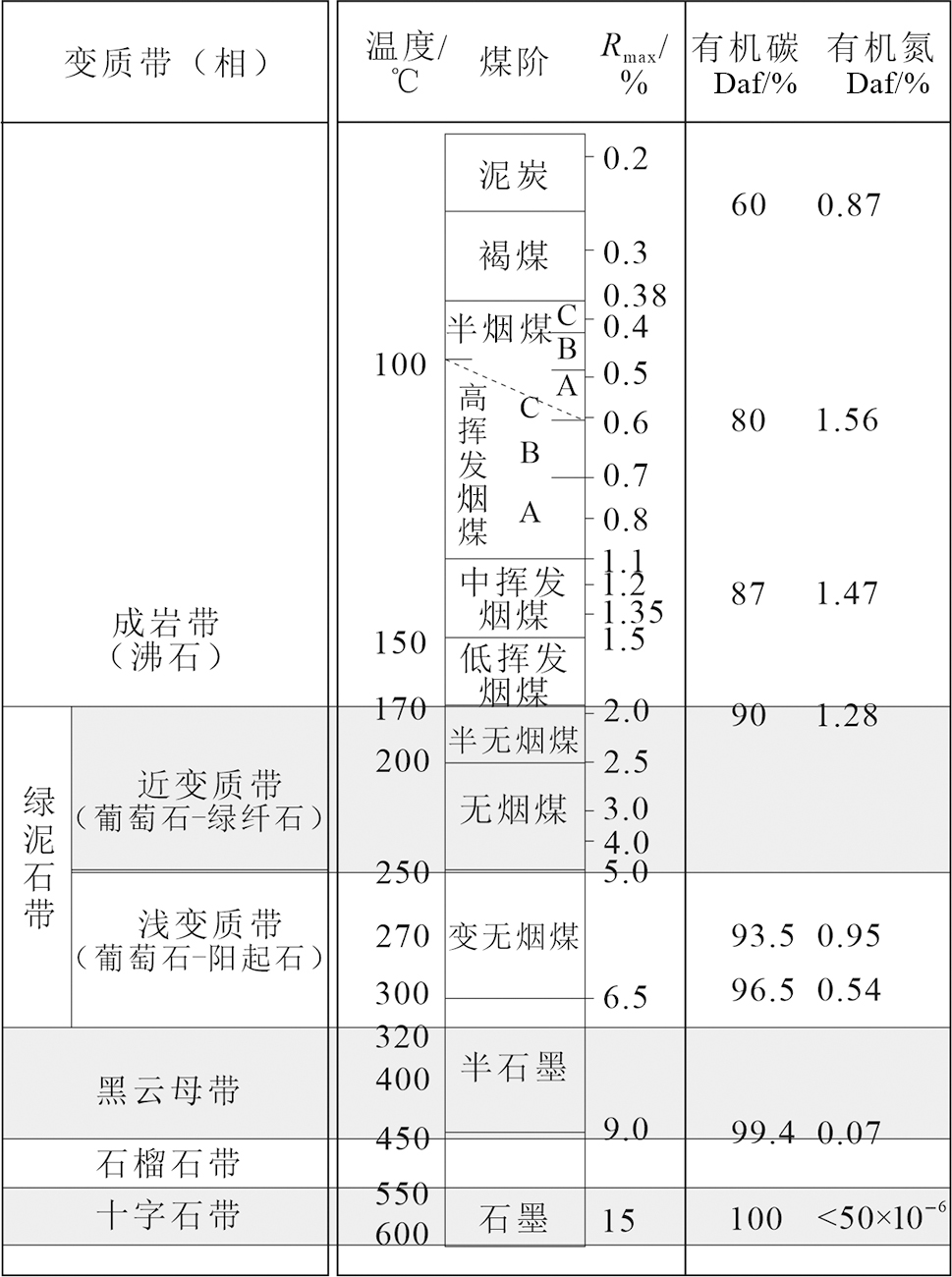
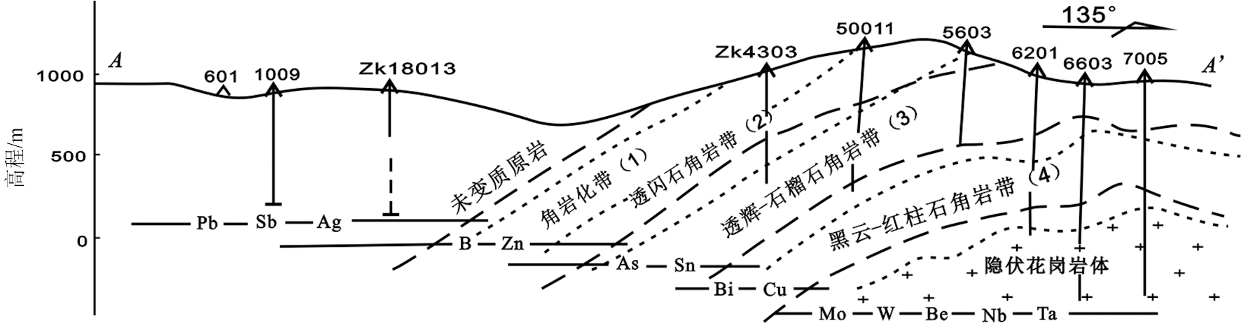
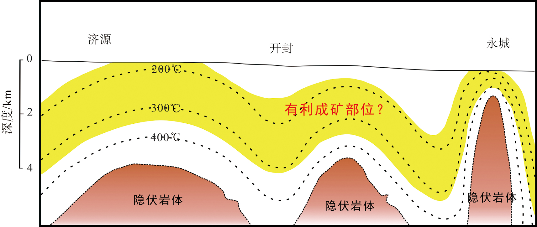
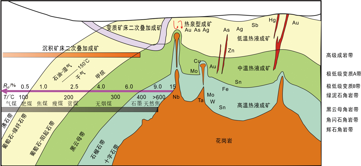
我们已经根据花岗岩的资料编制了一份山西省早白垩世下地壳地质图,本文增加了镜质组反射率资料,重新编制了一份山西省早白垩世下地壳地质图。经过对比,得出了许多新认识。对比说明,在下地壳填图中,镜质组反射率是一个非常有用的资料。镜质组反射率可以记录它形成以后所能够达到的最高温度,是煤田和石油地质部门成熟度测量中广泛应用且可靠的方法之一。镜质组反射率方法对岩石学和矿床学也非常有用,因此可以根据镜质组反射率资料推测深部是否有隐伏岩体以及隐伏岩体的分布和规模,推测下地壳底部是否有地幔上涌以及地幔上涌的分布。利用镜质组反射率分布寻找隐伏岩体,再根据隐伏岩体找矿,是一个找矿的新方法。文中根据山西省镜质组反射率的分布,推测在若干Ro>3.0%的地区的深部有可能发现隐伏岩体,其中,祁县隐伏岩体已经被钻探验证所证实。山西省煤矿很多,凡是无烟煤分布区均是寻找隐伏岩体的有利地区。文中还根据镜质组反射率资料对山西省早白垩世下地壳地质图进行了修改,指出山西省中部和南部的深部为大片中生代(主要是早白垩世)花岗岩分布区,也是早白垩世时地幔上涌的区域。根据地层资料和花岗岩资料推测山西省北部(大同以北)为地壳厚度正常区,南部为地壳加厚区(为中国东部高原的一部分)。南部为地幔上涌区,北部无地幔上涌迹象;故南部下地壳为高温榴辉岩相区,北部下地壳为低温榴辉岩相区。地表有矿产分布的区域,下地壳为含流体榴辉岩相区。山西省中部和西部的下地壳可能为榴辉岩相-麻粒岩相过渡区,暗示中国东部高原在山西省可能呈现为向西缓慢下降的趋势。

关键词: 山西省, 镜质组反射率, 无烟煤, 下地壳地质图, 隐伏岩体, 高原, 早白垩世

Abstract:

A geological map of the Early Cretaceous lower crust in Shanxi Province has been compiled based on granite data, which has added vitrinite reflectance data and recompiled the geological map of the Early Cretaceous lower crust in Shanxi Province. Many new insights have been obtained through comparison,which indicates that vitrinite reflectance is a very useful dataset for lower crustal mapping. Vitrinite reflectance can record the maximum temperature reached after its formation and is one of the widely used and reliable methods for maturity measurement in coalfield and petroleum geology departments. The vitrinite reflectance method is also very useful in petrology and mineral deposit studies. Therefore, it is possible to infer the presence, distribution, and scale of concealed rock mass in deeper layers, as well as the presence and distribution of mantle upwelling at the base of the lower crust based on vitrinite reflectance data. A new method for mineral exploration involves using vitrinite reflectance distribution to locate concealed rock masses and subsequently prospecting for mineral deposits based on these features.

This paper infers that concealed rock mass may exist in the deeper layers of several areas where Ro>3.0% based on the distribution of vitrinite reflectance in Shanxi Province. Among these, the concealed rock mass in Qixian has already been confirmed through drilling verification. There are many coal mines in Shanxi Province, and all anthracite distribution areas are favorable regions for locating concealed rock mass. The paper also revises the geological map of the Early Cretaceous lower crust in Shanxi Province based on vitrinite reflectance data, pointing out that the deeper layers in the central and southern parts of Shanxi Province are extensive regions of Mesozoic (mainly Early Cretaceous) granite distribution, which were also areas of mantle upwelling during the Early Cretaceous.It is inferred based on stratigraphic and granite data that the northern part of Shanxi Province (north of Datong) represents a region with normal crustal thickness, while the southern part represents a region of crustal thickening (part of the eastern China plateau). The southern part is a mantle upwelling region, while the northern part shows no signs of mantle upwelling. Therefore, the lower crust in the southern part is a high-temperature eclogite facies region, while the lower crust in the northern part is a low-temperature eclogite facies region. The lower crust is a fluid-bearing eclogite facies region in areas with surface mineral deposits. The lower crust in the central and western parts of Shanxi Province may represent a transitional zone between eclogite facies and granulite facies, suggesting that the eastern China plateau in Shanxi Province may exhibit a gradual westward subsidence trend.

Key words: Shanxi Province, vitrinite reflectance, anthracite, lower crust geological map, concealed rock mass, plateau, Early Cretaceous

中图分类号: