地学前缘 ›› 2025, Vol. 32 ›› Issue (5): 404-416.DOI: 10.13745/j.esf.sf.2025.7.17
印森林1( ), 林少玲1, 胡张明2,*(), 赵俊威1, 杨映涛3, 张玲3, 陈恭洋1, 陈玮常4
收稿日期:2024-06-10
修回日期:2024-12-21
出版日期:2025-09-25
发布日期:2025-10-14
通信作者:
胡张明
作者简介:印森林(1983—),男,副教授,博士生导师,主要从事无人机露头表征与建模研究。E-mail: yinxiang_love@qq.com
基金资助:
YIN Senlin1(), LIN Shaoling1, HU Zhangming2,*(), ZHAO Junwei1, YANG Yingtao3, ZHANG Ling3, CHEN Gongyang1, CHEN Weichang4
Received:2024-06-10
Revised:2024-12-21
Online:2025-09-25
Published:2025-10-14
Contact:
HU Zhangming
摘要:
四川盆地须家河组叠覆式分流河道砂体广泛发育,针对此类致密砂岩(微)裂缝型储层甜点分布模式不明确问题,利用无人机倾斜摄影露头数据资料、密集实物采样样品和电镜分析化验等资料,结合无人机倾斜摄影数字露头、能谱电镜分析、层次结构分析和三维地质建模等方法,开展了致密砂岩内部露头构型表征、储层构型精细建模、矿物三维定量模型和(微)裂缝结构空间分布等研究。研究表明:(1)无人机倾斜摄影数据采集处理后的三维模型中坐标体系与拍摄的高精度图像信息完美耦合,既实现了野外露头地质信息三维数字化、可视化和定量化,也为小尺度矿物三维非均质性研究奠定了数据基础。(2)剖面砂体构型呈厚层状连片状叠置,泥质隔夹层发育程度低;利用随机模拟算法开展了石英、长石、岩屑、白云石和方解石定量三维分布模型,揭示了小尺度矿物差异空间分布特征。(3)在(微)裂缝型储层甜点特征分析基础上,分析了石英、方解石矿物含量与(微)裂缝发育的相关程度很高,是甜点形成与发育的优质部位。无人机倾斜摄影数字露头技术与三维地质建模技术相结合不仅可以定量表征露头非均质性,而且对指导(微)裂缝型致密砂岩甜点储层的勘探开发意义重大。
中图分类号:
印森林, 林少玲, 胡张明, 赵俊威, 杨映涛, 张玲, 陈恭洋, 陈玮常. 致密砂岩储层内部矿物三维建模与裂缝型甜点分布:以川西工农镇野外露头剖面须二段为例[J]. 地学前缘, 2025, 32(5): 404-416.
YIN Senlin, LIN Shaoling, HU Zhangming, ZHAO Junwei, YANG Yingtao, ZHANG Ling, CHEN Gongyang, CHEN Weichang. 3D model of mineral interior tight sandstone reservoir and distribution of fracture dessert: Taking 2nd Xujiahe Formation outcrop section in western Sichuan Basin as an example[J]. Earth Science Frontiers, 2025, 32(5): 404-416.

图1 露头研究区位置图 a—区域地理位置;b—工区范围;c—研究区岩性柱状图。
Fig.1 Location of the outcrop study area

图2 无人机倾斜摄影模型与取样点分布
Fig.2 UAV oblique model and sampling point location
| 序号 | 钾长石 含量/ % | 石英 含量/ % | 斜长石 含量/ % | 白云石 含量/ % | 方解石 含量/ % | 铁白 云石 含量/% | 硅质类 矿物 含量/% | 钙质类 矿物 含量/% | 黏土 矿物 含量/% | 单位面积 裂缝条数/ cm2 | 单位面积 裂缝长度/ (mm·cm-2) | 裂缝 宽度/ μm | 孔隙度/ % |
|---|---|---|---|---|---|---|---|---|---|---|---|---|---|
| 1 | 0.88 | 25.21 | 1.03 | 10.39 | 58.11 | 0.55 | 27.12 | 69.05 | 2.32 | 804 | 518.73 | 388.52 | 1.49 |
| 2 | 0.85 | 21.74 | 0.88 | 2.07 | 69.86 | 0.28 | 23.47 | 72.21 | 2.61 | 1 500 | 459.63 | 154.85 | 3.43 |
| 3 | 0.65 | 28.4 | 0.64 | 11.84 | 55.66 | 0.16 | 29.69 | 67.66 | 1.93 | 400 | 405.01 | 662.9 | 1.13 |
| 4 | 0.94 | 34.37 | 0.82 | 14.2 | 44.07 | 0.12 | 36.13 | 58.39 | 4.25 | 459 | 407.49 | 579.44 | 1.86 |
| 5 | 0.76 | 26.69 | 0.67 | 10.95 | 57.67 | 0.22 | 28.12 | 68.84 | 2.06 | 348 | 430.79 | 833.17 | 1.61 |
| 6 | 0.83 | 26.4 | 0.72 | 11.27 | 57.75 | 0.16 | 27.95 | 69.18 | 2.11 | 762 | 491.89 | 386.22 | 1.48 |
| 7 | 1.3 | 37.45 | 0.79 | 9.62 | 44.33 | 0.17 | 39.54 | 54.12 | 4.92 | 717 | 356.82 | 278.48 | 3.48 |
| 8 | 1.16 | 40.66 | 0.98 | 7.98 | 40.98 | 0.16 | 42.8 | 49.12 | 6.58 | 735 | 419.94 | 341.16 | 1.83 |
| 9 | 1.03 | 31.79 | 0.81 | 12.31 | 42.62 | 0.07 | 33.63 | 55 | 9.3 | 1 014 | 364.79 | 173.51 | 5.33 |
| 10 | 1.38 | 30.22 | 0.74 | 6.14 | 54.31 | 0.4 | 32.34 | 60.85 | 5.18 | 1 088 | 398.27 | 186.49 | 7.7 |
| 11 | 1.05 | 26.25 | 0.73 | 10.63 | 56.87 | 0.34 | 28.03 | 67.84 | 3.21 | 332 | 430.39 | 894.08 | 1.19 |
| 12 | 1.22 | 30.55 | 0.85 | 11.8 | 50 | 0.19 | 32.62 | 61.99 | 4.23 | 456 | 474.83 | 691.66 | 1.49 |
| 13 | 1.1 | 30.75 | 0.89 | 12.95 | 48.6 | 0.13 | 32.74 | 61.68 | 4.34 | 439 | 423.57 | 632.84 | 1.5 |
| 14 | 0.46 | 25 | 0.49 | 9.98 | 58.99 | 0.07 | 25.95 | 69.04 | 4.05 | 383 | 391.66 | 693.03 | 1.16 |
| 15 | 1.24 | 23.39 | 0.79 | 7.67 | 62.79 | 0.18 | 25.42 | 70.64 | 2.98 | 231 | 385.88 | 1 201.39 | 1.12 |
| 16 | 2 | 24.46 | 0.83 | 6.89 | 51.39 | 0.78 | 27.29 | 59.06 | 8.35 | 472 | 428.36 | 584.89 | 1.27 |
| 17 | 1.32 | 26.77 | 0.86 | 9.78 | 55.94 | 0.16 | 28.95 | 65.88 | 4 | 353 | 426.62 | 836.34 | 1.41 |
| 18 | 1.3 | 30.96 | 0.52 | 0.36 | 58.92 | 0.16 | 32.78 | 59.44 | 5.83 | 1 493 | 449.33 | 144.3 | 3.91 |
| 19 | 0.3 | 24.35 | 0.4 | 7.74 | 61.8 | 0.06 | 25.05 | 69.6 | 4.52 | 549 | 452.42 | 519.44 | 1.47 |
| 20 | 0.97 | 27.69 | 0.81 | 10.37 | 56.14 | 0.16 | 29.47 | 66.67 | 3.03 | 361 | 417.64 | 798.18 | 1.22 |
表1 部分样品分析测试数据表
Table 1 Analysis and test data sheets of part samples
| 序号 | 钾长石 含量/ % | 石英 含量/ % | 斜长石 含量/ % | 白云石 含量/ % | 方解石 含量/ % | 铁白 云石 含量/% | 硅质类 矿物 含量/% | 钙质类 矿物 含量/% | 黏土 矿物 含量/% | 单位面积 裂缝条数/ cm2 | 单位面积 裂缝长度/ (mm·cm-2) | 裂缝 宽度/ μm | 孔隙度/ % |
|---|---|---|---|---|---|---|---|---|---|---|---|---|---|
| 1 | 0.88 | 25.21 | 1.03 | 10.39 | 58.11 | 0.55 | 27.12 | 69.05 | 2.32 | 804 | 518.73 | 388.52 | 1.49 |
| 2 | 0.85 | 21.74 | 0.88 | 2.07 | 69.86 | 0.28 | 23.47 | 72.21 | 2.61 | 1 500 | 459.63 | 154.85 | 3.43 |
| 3 | 0.65 | 28.4 | 0.64 | 11.84 | 55.66 | 0.16 | 29.69 | 67.66 | 1.93 | 400 | 405.01 | 662.9 | 1.13 |
| 4 | 0.94 | 34.37 | 0.82 | 14.2 | 44.07 | 0.12 | 36.13 | 58.39 | 4.25 | 459 | 407.49 | 579.44 | 1.86 |
| 5 | 0.76 | 26.69 | 0.67 | 10.95 | 57.67 | 0.22 | 28.12 | 68.84 | 2.06 | 348 | 430.79 | 833.17 | 1.61 |
| 6 | 0.83 | 26.4 | 0.72 | 11.27 | 57.75 | 0.16 | 27.95 | 69.18 | 2.11 | 762 | 491.89 | 386.22 | 1.48 |
| 7 | 1.3 | 37.45 | 0.79 | 9.62 | 44.33 | 0.17 | 39.54 | 54.12 | 4.92 | 717 | 356.82 | 278.48 | 3.48 |
| 8 | 1.16 | 40.66 | 0.98 | 7.98 | 40.98 | 0.16 | 42.8 | 49.12 | 6.58 | 735 | 419.94 | 341.16 | 1.83 |
| 9 | 1.03 | 31.79 | 0.81 | 12.31 | 42.62 | 0.07 | 33.63 | 55 | 9.3 | 1 014 | 364.79 | 173.51 | 5.33 |
| 10 | 1.38 | 30.22 | 0.74 | 6.14 | 54.31 | 0.4 | 32.34 | 60.85 | 5.18 | 1 088 | 398.27 | 186.49 | 7.7 |
| 11 | 1.05 | 26.25 | 0.73 | 10.63 | 56.87 | 0.34 | 28.03 | 67.84 | 3.21 | 332 | 430.39 | 894.08 | 1.19 |
| 12 | 1.22 | 30.55 | 0.85 | 11.8 | 50 | 0.19 | 32.62 | 61.99 | 4.23 | 456 | 474.83 | 691.66 | 1.49 |
| 13 | 1.1 | 30.75 | 0.89 | 12.95 | 48.6 | 0.13 | 32.74 | 61.68 | 4.34 | 439 | 423.57 | 632.84 | 1.5 |
| 14 | 0.46 | 25 | 0.49 | 9.98 | 58.99 | 0.07 | 25.95 | 69.04 | 4.05 | 383 | 391.66 | 693.03 | 1.16 |
| 15 | 1.24 | 23.39 | 0.79 | 7.67 | 62.79 | 0.18 | 25.42 | 70.64 | 2.98 | 231 | 385.88 | 1 201.39 | 1.12 |
| 16 | 2 | 24.46 | 0.83 | 6.89 | 51.39 | 0.78 | 27.29 | 59.06 | 8.35 | 472 | 428.36 | 584.89 | 1.27 |
| 17 | 1.32 | 26.77 | 0.86 | 9.78 | 55.94 | 0.16 | 28.95 | 65.88 | 4 | 353 | 426.62 | 836.34 | 1.41 |
| 18 | 1.3 | 30.96 | 0.52 | 0.36 | 58.92 | 0.16 | 32.78 | 59.44 | 5.83 | 1 493 | 449.33 | 144.3 | 3.91 |
| 19 | 0.3 | 24.35 | 0.4 | 7.74 | 61.8 | 0.06 | 25.05 | 69.6 | 4.52 | 549 | 452.42 | 519.44 | 1.47 |
| 20 | 0.97 | 27.69 | 0.81 | 10.37 | 56.14 | 0.16 | 29.47 | 66.67 | 3.03 | 361 | 417.64 | 798.18 | 1.22 |
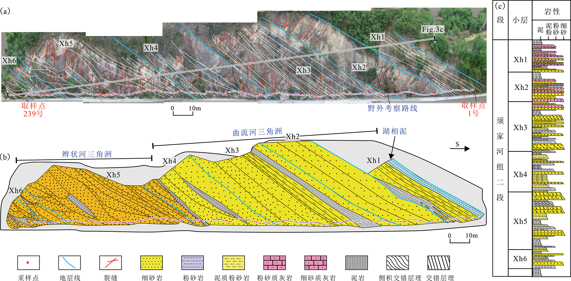
图3 露头区致密砂岩分流河道构型解剖 a—露头剖面致密砂岩构型和裂缝解释;b—工区分流河道致密砂岩构型解剖;c—露头岩性柱状图。
Fig.3 Tight sandstone in the outcrop area architecture of the distributary channel

图4 致密砂岩岩性、矿物与裂缝分布三维模型 a—岩性模型;b—白云石含量模型;c—方解石含量模型;d—长石含量模型;e—石英含量模型;f—黏土矿物含量模型;g—裂缝体积密度模型。
Fig.4 3D model of tight sandstone lithology, minerals and fracture distribution

图5 矿物含量与裂缝体积密度相关关系图
Fig.5 Correlation ship between minerals and fracture volume density

图6 Xh4小层矿物与裂缝体积密度分布图 a—白云石含量;b—方解石含量;c—长石含量;d—石英含量;e—黏土矿物含量;f—裂缝体积密度。
Fig.6 Mineral and fracture volume density distribution of Xh4 layer

图7 Xh1小层矿物与裂缝体密度分布图 a—白云石含量;b—方解石含量;c—长石含量;d—石英含量;e—黏土矿物含量;f—裂缝体积密度。
Fig.7 Mineral and fracture volume density distribution of Xh1 layer

图8 裂缝型、裂缝-基质型、基质型微观结构图 a—裂缝型储层微观结构;b—裂缝型储层孔隙-裂缝分布;c—裂缝型储层矿物含量;d—裂缝-基质型储层微观结构;e—裂缝-基质型储层孔隙-裂缝分布;f—裂缝-基质型储层矿物含量;g—基质型储层微观结构;h—基质型储层孔隙-裂缝分布;i—基质型储层矿物含量。
Fig.8 Microstructure of fracture type, fracture-matrix type, matrix type

图9 地下岩心裂缝型甜点分布特征 a—高角度缝,XC6井TX22 4 717.22~4 717.4 m;b—斜缝,X10井,TX24 4 886.15~4 886.46 m;c—酥饼溶蚀缝,XC8井,4 972.41~4 972.54 m;d—酥饼斜缝切平缝,XC8井,4 970.52~4 970.6 m。
Fig.9 Distribution characteristics of wells core fractured desserts
| 井号 | 测试层位 | 测试方式 | 流压/ MPa | 产气量/ (104 m3·d-1) | 产水量/ (104 m3·d-1) | 无阻流量/ (104 m3·d-1) | 试气结论 |
|---|---|---|---|---|---|---|---|
| 新场6井 | 须二段2砂组 | 射孔 | 70.64 | 3.79 | 120.96 | 24.05 | 低产含气水层 |
| 新场8井 | 须二段2、3砂组 | 中途测试 | 25.06 | 33.21 | 工业气层 | ||
| 新场10井 | 须二段4砂组 | 射孔 | 38.77 | 10.33 | 1.15 | 13.38 | 低产含气水层 |
表2 钻井测试与试气结论
Table 2 Drilling test and gas test conclusion
| 井号 | 测试层位 | 测试方式 | 流压/ MPa | 产气量/ (104 m3·d-1) | 产水量/ (104 m3·d-1) | 无阻流量/ (104 m3·d-1) | 试气结论 |
|---|---|---|---|---|---|---|---|
| 新场6井 | 须二段2砂组 | 射孔 | 70.64 | 3.79 | 120.96 | 24.05 | 低产含气水层 |
| 新场8井 | 须二段2、3砂组 | 中途测试 | 25.06 | 33.21 | 工业气层 | ||
| 新场10井 | 须二段4砂组 | 射孔 | 38.77 | 10.33 | 1.15 | 13.38 | 低产含气水层 |

图10 矿物含量与孔隙度统计关系
Fig.10 Statistical relationship between minerals and porosity
| [1] | 段金宝, 张升磊, 李平平, 等. 四川盆地北部须家河组裂缝发育特征与控制因素:以广元和旺苍地区地表露头为例[J]. 长江大学学报(自科版), 2016, 13(23): 7-14. |
| [2] | 刘忠群, 徐士林, 刘君龙, 等. 四川盆地川西坳陷深层致密砂岩气藏富集规律[J]. 天然气工业, 2020, 40(2): 31-40. |
| [3] | 刘君龙, 胡宗全, 刘忠群, 等. 四川盆地川西坳陷新场须家河组二段气藏甜点模式及形成机理[J]. 石油与天然气地质, 2021, 42(4): 852-862. |
| [4] | 于兴河, 李顺利, 杨志浩. 致密砂岩气储层的沉积-成岩成因机理探讨与热点问题[J]. 岩性油气藏, 2015, 27(1): 1-13. |
| [5] | 施振生, 李熙喆, 董大忠, 等. 致密砂岩储层成岩作用与孔隙演化: 以川西南上三叠统为例[J]. 地学前缘, 2018, 25(2): 179-190. |
| [6] | 丁文龙, 尹帅, 王兴华, 等. 致密砂岩气储层裂缝评价方法与表征[J]. 地学前缘, 2015, 22(4): 173-187. |
| [7] | 李王鹏, 刘忠群, 胡宗全, 等. 四川盆地川西坳陷新场须家河组二段致密砂岩储层裂缝发育特征及主控因素[J]. 石油与天然气地质, 2021, 42(4): 884-897. |
| [8] | 黄彦庆, 刘忠群, 王爱, 等. 四川盆地元坝地区上三叠统须家河组三段致密砂岩气甜点类型与分布[J]. 岩性油气藏, 2023, 35(2): 21-30. |
| [9] | LI Y, CHEN S J, QIU W, et al. Controlling factors for the accumulation and enrichment of tight sandstone gas in the Xujiahe Formation, Guang’an Area, Sichuan Basin[J]. Energy Exploration & Exploitation, 2019, 37(1) :26-33. |
| [10] | 潘磊, 杜红权, 李雷涛, 等. 川东北元坝地区上三叠统须家河组天然裂缝发育特征与主控因素[J]. 地学前缘, 2024, 31(5): 156-165. |
| [11] | 董少群, 曾联波, 冀春秋, 等. 超深层致密砂岩裂缝测井识别深度核方法[J]. 地学前缘, 2024, 31(5): 166-176. |
| [12] | 李云涛, 丁文龙, 韩俊, 等. 顺北地区走滑断裂带奥陶系碳酸盐岩裂缝分布预测与主控因素研究[J]. 地学前缘, 2024, 31(5): 263-287. |
| [13] | 韩鹏远, 丁文龙, 杨德彬, 等. 塔河油田奥陶系碳酸盐岩储层裂缝表征与主控因素分析[J]. 地学前缘, 2024, 31(5): 209-226. |
| [14] | 朱筱敏, 潘荣, 朱世发, 等. 致密储层研究进展和热点问题分析[J]. 地学前缘, 2018, 25(2): 141-146. |
| [15] | STROKER T M, HARR1S N B, ELLIOTT W C, et al. Diagenesis of a tight gas sand reservoir: Upper Cretaceous Mesaverde Group, Piceance Basin, Colorado[J]. Marine and Petroleum Geology, 2013, 40: 48-68. |
| [16] | NELSON P H. Pore-throat sizes in sandstones, tight sandstones, and shales[J]. AAPG Bulletin, 2009, 93(3): 329-340. |
| [17] | OLSON J E, LAUBACH S E, LANDER R H. Natural fracture characterization in tight gas sandstones: integrating mechanics and diagenesis[J]. AAPG Bulletin, 2009, 93(11): 1535-1549. |
| [18] | ZHOU C N, YANG Z, TAO S Z, et al. Continuous hydro-carbon accumulation over a large area as a distinguishing characteristic of unconventional petroleum: the Ordos Basin, North-Central China[J]. Earth-Science Reviews, 2013, 126: 358-369. |
| [19] | 曹晶晶. 致密砂岩储层构型研究:以广元工农镇须家河组野外露头为例[D]. 成都: 成都理工大学, 2020. |
| [20] | 印森林, 陈恭洋, 张玲, 等. 岩相构型对致密砂岩优质储层的控制作用:以川西坳陷须二段为例[J]. 天然气地球科学, 2016, 27(7):1179-1189. |
| [21] | YUE D L, WU S H, XU Z Y, et al. Reservoir quality, natural fractures, and gas productivity of upper Triassic Xujiahe tight gas sandstones in western Sichuan Basin, China[J]. Marine and Petroleum Geology, 2018, 89(2): 370-386. |
| [22] | 印森林, 陈恭洋, 刘兆良, 等. 基于无人机倾斜摄影的三维数字露头表征技术[J]. 沉积学报, 2018, 36(1): 72-80. |
| [23] | 印森林, 谭媛元, 张磊, 等. 基于无人机倾斜摄影的三维露头地质建模:以山西吕梁市坪头乡剖面为例[J]. 古地理学报, 2018, 20(5): 909-924. |
| [24] | 印森林, 高阳, 胡张明, 等. 基于无人机倾斜摄影的露头多点地质统计模拟:以山西吕梁坪头乡石盒子组为例[J]. 石油学报, 2021, 42(2): 198-216. |
| [25] | 王洛锋, 王功文, 许文辉, 等. 智能矿山大数据的地学信息挖掘与知识发现:以河南上房沟钼(铁)5G+矿山为例[J]. 地学前缘, 2023, 30(4): 317-334. |
| [26] | YIN S L, FENG K Y, NIE X, et al. Characterization of marine shale in Western Hubei Province based on unmanned aerial vehicle oblique photographic data[J]. Geo-Energy Research, 2022, 6(3): 252-263. |
| [27] | YIN S L, ZHU B Y, GUO H P, et al. Architectural model of a dryland gravel braided river, based on 3D UAV oblique photogrammetric data: a case study of West Dalongkou river in eastern Xinjiang, China[J]. Acta Geologica Sinica (English Edition), 2023, 97(1): 269-285. |
| [28] | 王珂, 张荣虎, 李宝刚, 等. 致密砂岩储层构造裂缝特征及地质建模:以塔里木盆地库车坳陷大北12气藏为例[J]. 海相油气地质, 2023, 28(1): 72-82. |
| [29] | 董少群, 吕文雅, 夏东领, 等. 致密砂岩储层多尺度裂缝三维地质建模方法[J]. 石油与天然气地质, 2020, 41(3): 627-637. |
| [30] | 刘剑锋, 王鹏, 毛庆辉, 等. 基于不同尺度的储层裂缝建模方法对比[J]. 地球物理学进展, 2023, 38(5): 2071-2079. |
| [31] | SALAZAR JJ, OCHOA J, GARLAND L, et al. Spatial data analytics-assisted subsurface modeling: a duvernay case study[J]. Petrophysics, 2023, 64(2): 287-302. |
| [32] | 刘昭茜, 罗开平, 唐永, 等. 四川盆地元坝-通南巴地区关键构造期构造特征及陆相致密砂岩天然气成藏响应[J]. 地球科学, 2019, 44(3): 756-772. |
| [33] | HE D, DUAN X G, LI S M, et al. Impact of depositional environment and diagenesis on the Upper Triassic Xujiahe tight-sand reservoir in Guang’an area, Central Sichuan Basin, SW China[J]. Carbonates and Evaporites, 2019, 34(2): 219-232. |
| [34] | 叶素娟, 李嵘, 杨克明, 等. 川西坳陷叠覆型致密砂岩气区储层特征及定量预测评价[J]. 石油学报, 2015, 36(12): 1484-1494. |
| [35] | 余瑜, 林良彪, 李真, 等. 致密砂岩碳酸盐矿物SEM-CL和EPMA矿物学表征及其成岩意义:以川西坳陷须家河组为例[J]. 沉积学报, 2023, 41(5): 1468-1477. |
| [36] | 陈磊, 姜振学, 纪文明, 等. 川西坳陷上三叠统须五段陆相页岩气储集层矿物成分特征及其意义[J]. 矿物岩石地球化学通报, 2016, 35(4): 750-755. |
| [1] | 王武荣, 刘显阳, 岳大力, 万晓龙, 刘瑞璟, 李士祥, 卢浩, 刘建, 吴光圳, 吴胜和. 坳陷湖盆湖底扇致密砂岩储层质量差异分布:以鄂尔多斯盆地合水地区延长组长6油组为例[J]. 地学前缘, 2025, 32(5): 190-204. |
| [2] | 何晓, 牛花朋, 赵贤, 周浩彦, 林伟峻, 张关龙, 孟涛, 穆星. 基于数值模拟表征岩石组构对裂缝性储层发育影响程度的机理研究:以济阳坳陷花岗质岩石为例[J]. 地学前缘, 2025, 32(5): 361-376. |
| [3] | 屈林博, 岳大力, 王武荣, 金武军, 赖合川, 武清钊, 廖昌珍, 付家麟, 张佳睿, 李伟. 双重介质致密砂岩变岩电参数饱和度模型:以川西新场气田须二段为例[J]. 地学前缘, 2025, 32(5): 377-388. |
| [4] | 张涛, 李艳萍, 李泽凯, 刘东成, 王静. 基于改进长短记忆神经网络的深层致密储层裂缝测井识别[J]. 地学前缘, 2025, 32(5): 456-465. |
| [5] | 胡景宏, 廖松泽, 蔡益栋, 芦俊. 深部页岩储层压裂裂缝扩展均匀性研究[J]. 地学前缘, 2025, 32(4): 471-482. |
| [6] | 齐晓飞, 肖勇, 上官拴通, 苏野, 王红科, 李英英, 胡志兴. 马头营深层干热岩人工造储裂缝扩展机理研究与应用[J]. 地学前缘, 2024, 31(6): 224-234. |
| [7] | 丁文龙, 王垚, 张子游, 刘天顺, 程晓云, 勾通, 王生晖, 刘霆锋. 页岩储层构造裂缝活动期次及开启性研究进展与展望[J]. 地学前缘, 2024, 31(5): 1-16. |
| [8] | 刘艳祥, 吕文雅, 曾联波, 李睿琦, 董少群, 王兆生, 李彦录, 王磊飞, 冀春秋. 鄂尔多斯盆地庆城油田长7页岩油储层多尺度裂缝三维地质建模[J]. 地学前缘, 2024, 31(5): 103-116. |
| [9] | 鞠玮, 杨慧, 侯贵廷, 宁卫科, 李永康, 梁孝柏. 复杂构造变形区断控裂缝发育分布模式[J]. 地学前缘, 2024, 31(5): 130-138. |
| [10] | 尹帅, 张子阳, 张星星, 王景辰, 胡伟, 丁文龙, 李虎. 扇三角洲前缘非常规致密油储层裂缝发育模式:以泌阳凹陷东南部古近系核三段为例[J]. 地学前缘, 2024, 31(5): 139-155. |
| [11] | 潘磊, 杜红权, 李雷涛, 龙涛, 殷雪峰. 川东北元坝地区上三叠统须家河组天然裂缝发育特征与主控因素[J]. 地学前缘, 2024, 31(5): 156-165. |
| [12] | 董少群, 曾联波, 冀春秋, 张延兵, 郝静茹, 徐小童, 韩高松, 徐辉, 李海明, 李心琦. 超深层致密砂岩裂缝测井识别深度核方法[J]. 地学前缘, 2024, 31(5): 166-176. |
| [13] | 何建华, 曹红秀, 邓虎成, 印长海, 朱彦平, 李厂, 李勇, 尹帅. 川东北营山-平昌地区凉高山组页岩天然裂缝发育特征及其形成演化模式研究[J]. 地学前缘, 2024, 31(5): 17-34. |
| [14] | 张辉, 张冠杰, 徐珂, 尹国庆, 王志民, 罗洋, 王海应, 张滨鑫, 梁景瑞, 袁芳, 赵崴, 张玮, 卢星. 库车坳陷应力状态转换特征及其地质与力学响应[J]. 地学前缘, 2024, 31(5): 177-194. |
| [15] | 高玉巧, 花彩霞, 蔡潇, 白鸾羲, 卢葭. 苏北盆地溱潼凹陷阜宁组二段页岩油储层裂缝形成机制及对烃类赋存的影响[J]. 地学前缘, 2024, 31(5): 35-45. |
| 阅读次数 | ||||||
|
全文 |
|
|||||
|
摘要 |
|
|||||