Earth Science Frontiers ›› 2024, Vol. 31 ›› Issue (2): 343-358.DOI: 10.13745/j.esf.sf.2023.2.54
Previous Articles Next Articles
XU Zhaohui1( ), HU Suyun1, ZENG Hongliu2, MA Debo1, LUO Ping1, HU Zaiyuan3, SHI Shuyuan1, CHEN Xiuyan1, TAO Xiaowan1
Received:2022-11-26
Revised:2023-01-13
Online:2024-03-25
Published:2024-04-18
CLC Number:
XU Zhaohui, HU Suyun, ZENG Hongliu, MA Debo, LUO Ping, HU Zaiyuan, SHI Shuyuan, CHEN Xiuyan, TAO Xiaowan. Distribution and hydrocarbon significance of source rock in the Upper Xiaoerbulake Formation, Tarim Basin, NW China[J]. Earth Science Frontiers, 2024, 31(2): 343-358.

Fig.1 Lithology and TOC of Xiaoerbulake Formation in Tarim Basin (The black line in TOC column marks 0.3%)

Fig.2 Paleogeography of Tarim Basin in Early Cambrian and data locations. Modified after [39-40].
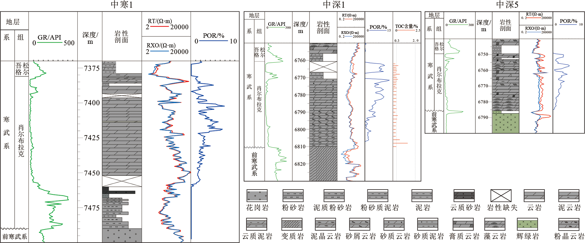
Fig.3 Well lithology-electrical features of Xiaoerbulake Formation in Tazhong area, Tarim Basin

Fig.4 Well lithology column and TOC of Cambrian in Tabei area, Tarim Basin
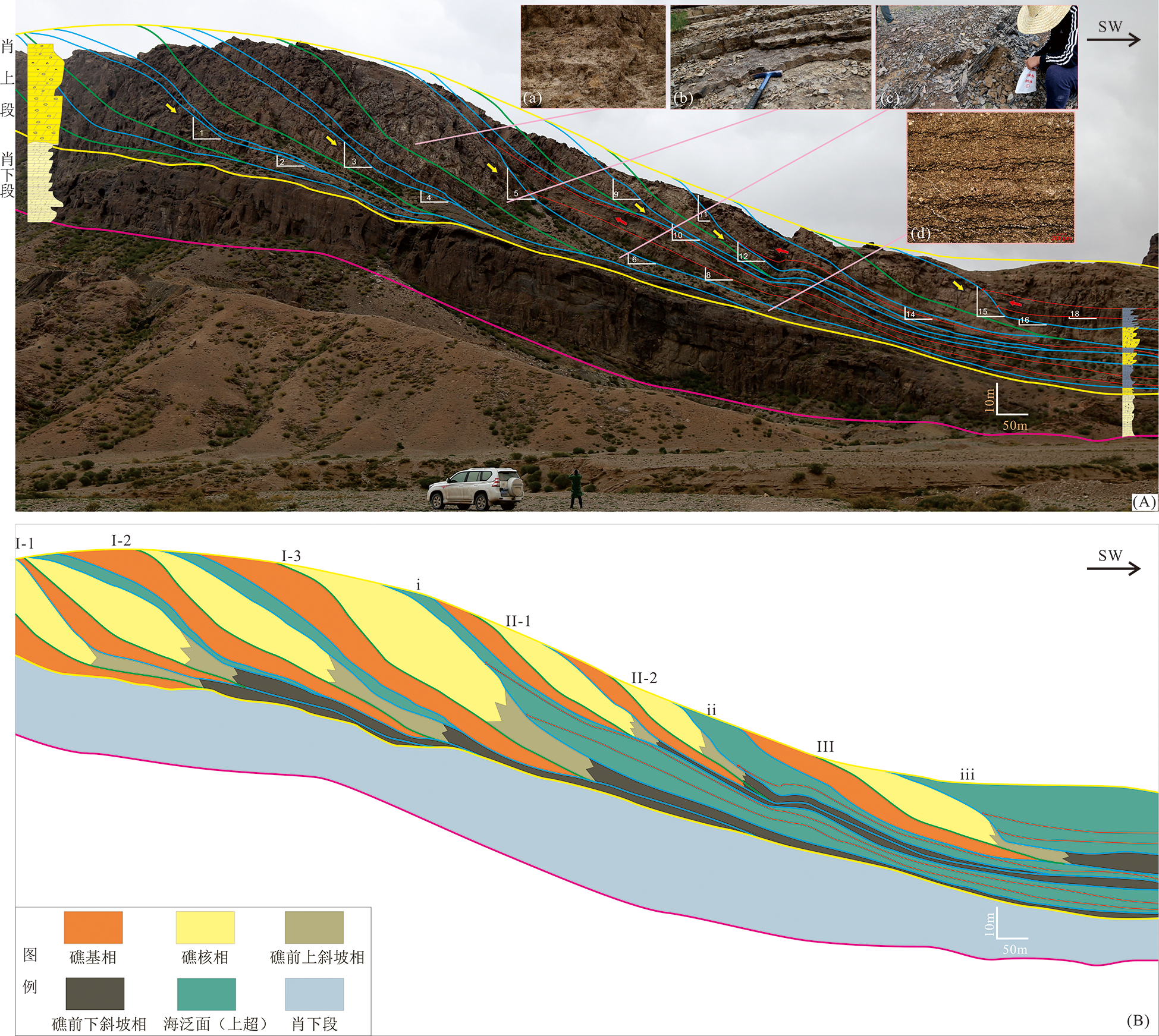
Fig.5 Features of reef-shoal-source rock system at Sugaitebulake outcrop (A) and the corresponding geologic profile (B) in Xiaoerbulake Formation, Tarim Basin (Yellow arrows indicate prograding reef-shoal systems, red arrows indicate transgressing systems)
| 序号 | 描述 | 礁前倾 角/(°) | 礁前古 坡度/(°) | 坡脚倾 角/(°) | 坡脚古 坡度/(°) | |
|---|---|---|---|---|---|---|
| 1 | 前积体I-1 | 9.1 | 5.3 | — | — | |
| 2 | — | — | 4.5 | 0.7 | ||
| 3 | 前积体I-2 | 10.3 | 6.6 | — | — | |
| 4 | — | — | 4.7 | 0.9 | ||
| 5 | 前积体I-3 | 12.2 | 8.4 | — | — | |
| 6 | — | — | 4.1 | 0.4 | ||
| 7 | 超覆体i | — | — | — | — | |
| 8 | — | — | 4.9 | 1.2 | ||
| 9 | 前积体II-1 | 8.1 | 4.3 | — | — | |
| 10 | — | — | 6.5 | 2.7 | ||
| 11 | 前积体II-2 | 23.6 | 19.9 | — | — | |
| 12 | — | — | 7.7 | 3.9 | ||
| 13 | 超覆体ii | — | — | — | — | |
| 14 | — | — | 4.9 | 1.1 | ||
| 15 | 前积体III | 11.6 | 7.9 | — | — | |
| 16 | — | — | 2.2 | 0.5 | ||
| 17 | 超覆体iii | — | — | — | — | |
| 18 | — | — | 1.8 | 0.3 |
Table 1 Dip of Upper Xiaoerbulake Formation calculated from Sugaitebulake outcrop, Tarim Basin
| 序号 | 描述 | 礁前倾 角/(°) | 礁前古 坡度/(°) | 坡脚倾 角/(°) | 坡脚古 坡度/(°) | |
|---|---|---|---|---|---|---|
| 1 | 前积体I-1 | 9.1 | 5.3 | — | — | |
| 2 | — | — | 4.5 | 0.7 | ||
| 3 | 前积体I-2 | 10.3 | 6.6 | — | — | |
| 4 | — | — | 4.7 | 0.9 | ||
| 5 | 前积体I-3 | 12.2 | 8.4 | — | — | |
| 6 | — | — | 4.1 | 0.4 | ||
| 7 | 超覆体i | — | — | — | — | |
| 8 | — | — | 4.9 | 1.2 | ||
| 9 | 前积体II-1 | 8.1 | 4.3 | — | — | |
| 10 | — | — | 6.5 | 2.7 | ||
| 11 | 前积体II-2 | 23.6 | 19.9 | — | — | |
| 12 | — | — | 7.7 | 3.9 | ||
| 13 | 超覆体ii | — | — | — | — | |
| 14 | — | — | 4.9 | 1.1 | ||
| 15 | 前积体III | 11.6 | 7.9 | — | — | |
| 16 | — | — | 2.2 | 0.5 | ||
| 17 | 超覆体iii | — | — | — | — | |
| 18 | — | — | 1.8 | 0.3 |

Fig.6 Pseudo wells distribution (A), impedance model (B), and synthetic section using Racker wavelet (-90°, 60 Hz) in Xiaoerbulake Formation at Sugaitebulake outcrop, Tarim Basin
| 相序号 | 相区 | 平均波阻抗/[(m·s-1)·(g·cm-3)] |
|---|---|---|
| 1 | 礁脊 | 16 100 |
| 2 | 礁内 | 16 100 |
| 3 | 礁基 | 16 150 |
| 4 | 外礁/滩 | 16 500 |
| 5 | 半局限台地 | 16 500 |
| 6 | 上斜坡 | 16 700 |
| 7 | 下斜坡 | 16 800 |
| 8 | 海侵域 | 16 750 |
Table 2 Parameters used in forward modelling. Modified after [52].
| 相序号 | 相区 | 平均波阻抗/[(m·s-1)·(g·cm-3)] |
|---|---|---|
| 1 | 礁脊 | 16 100 |
| 2 | 礁内 | 16 100 |
| 3 | 礁基 | 16 150 |
| 4 | 外礁/滩 | 16 500 |
| 5 | 半局限台地 | 16 500 |
| 6 | 上斜坡 | 16 700 |
| 7 | 下斜坡 | 16 800 |
| 8 | 海侵域 | 16 750 |

Fig.7 Time structure map of Lower Cambrian top (A) and typical seismic profiles (B, C) in Gucheng, Tarim Basin The while lines outline location of the abnormal zone on plane map and profiles; Yellow, cyan, and green lines indicate top, middle and base of Lower Cambrian

Fig.8 Seismic profile features of Lower Cambrian with different dominant frequencies in Gucheng 3D seismic survey, Tarim Basin (Flattened to top of Lower Cambrian)

Fig.9 Wheeler-domain seismic profile (A) and #36 stratal slice (B) derived from -90°, high frequency data in Lower Cambrian Gucheng, Tarim Basin
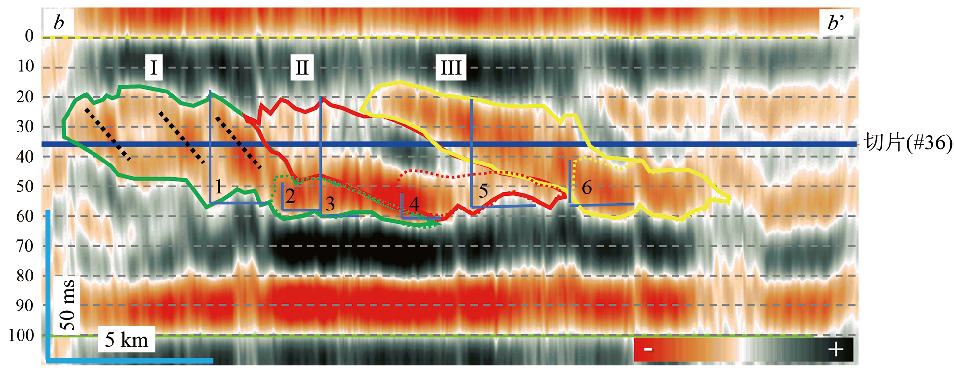
Fig.10 Interpretation of reef-shoal-source system on the Wheeler domain profile in Gucheng, Tarim Basin (Grey dashed lines are slice locations)
| 序号 | 描述 | 倾角/(°) (按轮探1井速度计) | 倾角/(°) (按磨溪19井速度计) |
|---|---|---|---|
| 1 | 前积体I礁前 | 3.9 | 4.1 |
| 2 | 前积体I坡脚 | 1.4 | 1.5 |
| 3 | 前积体II礁前 | 6.0 | 6.3 |
| 4 | 前积体II坡脚 | 1.3 | 1.4 |
| 5 | 前积体III礁前 | 3.4 | 3.6 |
| 6 | 前积体III坡脚 | 1.3 | 1.4 |
Table 3 Dip calculated from seismic data in Upper Xiaoerbulake Formation of Gucheng, Tarim Basin
| 序号 | 描述 | 倾角/(°) (按轮探1井速度计) | 倾角/(°) (按磨溪19井速度计) |
|---|---|---|---|
| 1 | 前积体I礁前 | 3.9 | 4.1 |
| 2 | 前积体I坡脚 | 1.4 | 1.5 |
| 3 | 前积体II礁前 | 6.0 | 6.3 |
| 4 | 前积体II坡脚 | 1.3 | 1.4 |
| 5 | 前积体III礁前 | 3.4 | 3.6 |
| 6 | 前积体III坡脚 | 1.3 | 1.4 |

Fig.11 Stratal slices of Lower Cambrian in Gucheng area, Tarim Basin (A to F is slices from 40, 44, 48, 52, 56, 60 ms, respectively)
| 切片时间/ms | 泥灰岩面积/km2 |
|---|---|
| 40 | 22.3 |
| 44 | 29.5 |
| 48 | 74.6 |
| 52 | 104.1 |
| 56 | 162.9 |
| 60 | 167.8 |
Table 4 Aera of argillaceous limestone calculated on different slices
| 切片时间/ms | 泥灰岩面积/km2 |
|---|---|
| 40 | 22.3 |
| 44 | 29.5 |
| 48 | 74.6 |
| 52 | 104.1 |
| 56 | 162.9 |
| 60 | 167.8 |
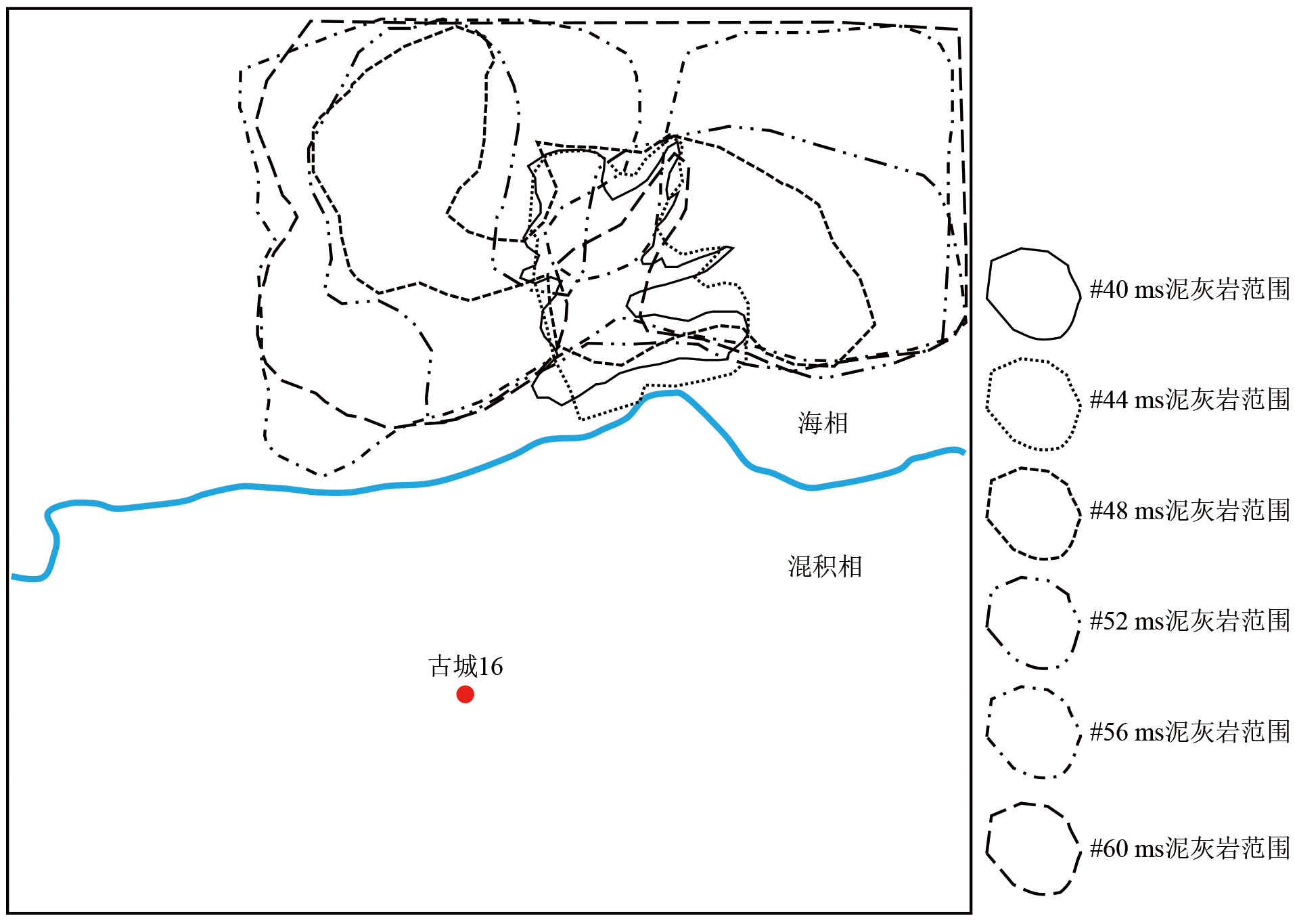
Fig.12 Overlapped distribution of argillaceous limestone in Upper Xiaoerbulake Formation on different slices in Gucheng area, Tarim Basin

Fig.13 Wheeler domain blended frequency-decomposed profiles for Upper Xiaoerbulake Formation in Gucheng area, Tarim Basin
| [1] | SCHOENHERR J, URAI J L, KUKLA P A, et al. Limits to the sealing capacity of rock salt: a case study of the infra-Cambrian Ara Salt from the South Oman salt basin[J]. AAPG Bulletin, 2007, 91(11): 1541-1557. |
| [2] | 吕修祥, 白忠凯, 付辉. 从东西伯利亚看塔里木盆地寒武系盐下碳酸盐岩勘探前景[J]. 新疆石油地质, 2009, 30(2): 157-162. |
| [3] | SNEDDEN J W, CUNNINGHAM R C, VIRDELL J W. The northern Gulf of Mexico offshore super basin: reservoirs, source rocks, seals, traps, and successes[J]. AAPG Bulletin, 2020, 104(12): 2603-2642. |
| [4] | 马永生, 黎茂稳, 蔡勋育, 等. 中国海相深层油气富集机理与勘探开发: 研究现状、关键技术瓶颈与基础科学问题[J]. 石油与天然气地质, 2020, 41(4): 655-672, 683. |
| [5] | LI D S, LIANG D G, JIA C Z, et al. Hydrocarbon accumulations in the Tarim Basin, China[J]. AAPG Bulletin, 1996, 80(10): 1587-1603. |
| [6] | 蔡希源. 塔里木盆地大中型油气田成控因素与展布规律[J]. 石油与天然气地质, 2007, 28(6): 693-702. |
| [7] | 杜金虎, 潘文庆. 塔里木盆地寒武系盐下白云岩油气成藏条件与勘探方向[J]. 石油勘探与开发, 2016, 43(3): 327-339. |
| [8] | 田军. 塔里木盆地油气勘探成果与勘探方向[J]. 新疆石油地质, 2019, 40(1): 1-11. |
| [9] | 杨海军, 陈永权, 田军, 等. 塔里木盆地轮探1井超深层油气勘探重大发现与意义[J]. 中国石油勘探, 2020, 25(2): 62-72. |
| [10] | DAHL J E P, MOLDOWAN J M, TEERMAN S C, et al. Source rock quality determination from oil biomarkers I: a new geochemical technique[J]. AAPG Bulletin, 1994, 78(10): 1507-1526. |
| [11] | 杨威, 魏国齐, 王清华, 等. 塔里木盆地寒武系两类优质烃源岩及其形成的含油气系统[J]. 石油与天然气地质, 2004, 25(3): 263-267. |
| [12] | 赵宗举, 周新源, 郑兴平, 等. 塔里木盆地主力烃源岩的诸多证据[J]. 石油学报, 2005, 26(3): 10-15. |
| [13] | 张水昌, 高志勇, 李建军, 等. 塔里木盆地寒武系—奥陶系海相烃源岩识别与分布预测[J]. 石油勘探与开发, 2012, 39(3): 285-294. |
| [14] | 云金表, 金之钧, 解国军. 塔里木盆地下古生界主力烃源岩分布[J]. 石油与天然气地质, 2014, 35(6): 827-838. |
| [15] | 樊奇, 樊太亮, 李清平, 等. 塔里木北缘震旦纪—寒武纪转折期碳同位素漂移事件及成因机制[J]. 地学前缘, 2021, 28(5): 436-447. |
| [16] | 李峰, 朱光有, 吕修祥, 等. 塔里木盆地古生界海相油气来源争议与寒武系主力烃源岩的确定[J]. 石油学报, 2021, 42(11): 1417-1436. |
| [17] | 陈强路, 储呈林, 杨鑫, 等. 塔里木盆地寒武系沉积模式与烃源岩发育[J]. 石油实验地质, 2015, 37(6): 689-695. |
| [18] | 陈强路, 杨鑫, 储呈林, 等. 塔里木盆地寒武系烃源岩沉积环境再认识[J]. 石油与天然气地质, 2015, 36(6): 880-887. |
| [19] | 谢李. 下古生界海相碳酸盐岩烃源岩研究[D]. 北京: 中国石油大学(北京), 2016. |
| [20] | 宋金民, 罗平, 杨式升, 等. 塔里木盆地苏盖特布拉克地区下寒武统肖尔布拉克组碳酸盐岩微生物建造特征[J]. 古地理学报, 2012, 14(3): 341-354. |
| [21] | TISSOT B P, WELTE D H. Petroleum formation and occurrence: a new approach to oil and gas exploration[M]. Berlin: Springer-Verlag, 1978. |
| [22] | 王兆云, 赵文智, 王云鹏. 中国海相碳酸盐岩气源岩评价指标研究[J]. 自然科学进展, 2004, 14(11): 1236-1243. |
| [23] | 秦建中, 李志明, 刘宝泉, 等. 海相优质烃源岩形成重质油与固体沥青潜力分析[J]. 石油实验地质, 2007, 29(3): 280-285, 291. |
| [24] | 宋到福, 王铁冠, 李美俊. 塔中地区中深1和中深1C井盐下寒武系油气地球化学特征及其油气源判识[J]. 中国科学: 地球科学, 2016, 46(1): 107-117. |
| [25] | 白海鹏, 刘学清, 商国玺, 等. 柯探1井高钙盐水层的钻井液技术[J]. 石油地质与工程, 2021, 35(1): 105-108. |
| [26] | XU Z H, ZENG H L, WANG L, et al. Sedimentary facies and reservoir characterization in a deep-buried Cambrian carbonate platform-to-basin area, Tarim Basin, northwestern China[C]// IMAGE (SEG and AAPG) expanded abstracts, 2021. |
| [27] | TRASK P D. The potential value of several recent American coastal and inland deposits as future source beds of petroleum[J]. AAPG Bulletin, 1928, 12(11): 1057-1068. |
| [28] | HEDBERG H D. Cretaceous limestone as petroleum source rock in northwestern Venezuela[J]. AAPG Bulletin, 1931, 15(3): 229-246. |
| [29] | WANG H D, PHILP R P. Geochemical study of potential source rocks and crude oils in the Anadarko Basin, Oklahoma[J]. AAPG Bulletin, 1997, 81(2): 249-275. |
| [30] | PAUL J S, JOHN M P, GEORGE E C. Petroleum source-bed evaluation of Jurassic twin creek limestone, Idaho-Wyoming thrust belt: geologic notes[J]. AAPG Bulletin, 1978, 62(6): 1075-1080. |
| [31] | STOUT W. Source material for petroleum and natural gas[J]. AAPG Bulletin, 1936, 20(6): 797-804. |
| [32] | RICHARD R V, WILLIAM E C. Exploration for oil accumulations in Entrada Sandstone, San Juan Basin, New Mexico[J]. AAPG Bulletin, 1981, 65(12): 2546-2570 |
| [33] | 白莹, 罗平, 刘伟, 等. 微生物碳酸盐岩储层特征及主控因素: 以塔里木盆地阿克苏地区下寒武统肖尔布拉克组上段为例[J]. 中国石油勘探, 2018, 23(4): 95-106. |
| [34] | ALSHARHAN A S, KENDALL C G ST C. Precambrian to Jurassic rocks of Arabian Gulf and adjacent areas: their facies, depositional setting, and hydrocarbon habitat[J]. AAPG Bulletin, 1986, 70(8): 977-1002. |
| [35] | 朱井泉, 吴仕强, 王国学, 等. 塔里木盆地寒武—奥陶系主要白云岩类型及孔隙发育特征[J]. 地学前缘, 2008, 15(2): 67-79. |
| [36] | 贾承造. 塔里木盆地构造特征与油气聚集规律[J]. 新疆石油地质, 1999, 20(3): 177-183. |
| [37] | 王清华, 杨海军, 李勇, 等. 塔里木盆地富满大型碳酸盐岩油气聚集区走滑断裂控储模式[J]. 地学前缘, 2022, 29(6): 239-251. |
| [38] | 王招明, 谢会文, 陈永权, 等. 塔里木盆地中深1井寒武系盐下白云岩原生油气藏的发现与勘探意义[J]. 中国石油勘探, 2014, 19(2): 1-13. |
| [39] | 胡明毅, 孙春燕, 高达. 塔里木盆地下寒武统肖尔布拉克组构造-岩相古地理特征[J]. 石油与天然气地质, 2019, 40(1): 12-23. |
| [40] | 朱永进, 倪新锋, 刘玲利, 等. 裂后沉降期碳酸盐岩缓坡沉积响应及成储特征: 以塔里木盆地下寒武统肖尔布拉克组为例[J]. 沉积学报, 2019, 37(5): 1044-1057. |
| [41] | 张光亚, 刘伟, 张磊, 等. 塔里木克拉通寒武纪—奥陶纪原型盆地、岩相古地理与油气[J]. 地学前缘, 2015, 22(3): 269-276. |
| [42] | 张水昌, WANG R L, 金之钧, 等. 塔里木盆地寒武纪—奥陶纪优质烃源岩沉积与古环境变化的关系: 碳氧同位素新证据[J]. 地质学报, 2006, 80(3): 459-466. |
| [43] | 高孝巧. 塔里木盆地巴楚—塔中地区肖尔布拉克组沉积特征及控储机理[D]. 北京: 中国地质大学(北京), 2018. |
| [44] | 夏新宇, 戴金星. 碳酸盐岩生烃指标及生烃量评价的新认识[J]. 石油学报, 2000, 21(4): 36-41, 121. |
| [45] | 云露, 翟晓先. 塔里木盆地塔深1井寒武系储层与成藏特征探讨[J]. 石油与天然气地质, 2008, 29(6): 726-732. |
| [46] | FRYKLUND B, STARK P. Super basins: the basins that keep on giving[EB/OL]. (2016-03-10)[2022-10-01]. https://ihsmarkit.com/solutions/permian-basin.html. |
| [47] | 宋金民, 罗平, 杨式升, 等. 塔里木盆地下寒武统微生物碳酸盐岩储集层特征[J]. 石油勘探与开发, 2014, 41(4): 404-413, 437. |
| [48] | 刘伟, 黄擎宇, 白莹, 等. 同生-准同生期大气淡水溶蚀对微生物碳酸盐岩储层的控制作用: 以塔里木盆地下寒武统为例[J]. 地学前缘, 2021, 28(1): 225-234. |
| [49] | 宋金民, 罗平, 杨式升, 等. 苏盖特布拉克地区下寒武统微生物礁演化特征[J]. 新疆石油地质, 2012, 33(6): 668-671. |
| [50] | 李莹, 潘文庆, 吴亚生, 等. 塔里木盆地苏盖特布拉克剖面寒武系第二统第三阶微生物岩结构类型[J]. 古地理学报, 2020, 22(4): 663-679. |
| [51] | 黄擎宇, 胡素云, 潘文庆, 等. 台内微生物丘沉积特征及其对储层发育的控制: 以塔里木盆地柯坪—巴楚地区下寒武统肖尔布拉克组为例[J]. 天然气工业, 2016, 36(6): 21-29. |
| [52] | ZENG H, XU Z H, LIU W, et al. Seismic-informed carbonate shelf-to-basin transition in deeply buried Cambrian strata, Tarim Basin, China[J]. MPG, 2021, 136: 1-18. |
| [53] | 沈安江, 张友, 冯子辉, 等. 塔东古城地区碳酸盐岩储层地质认识与勘探领域[J]. 中国石油勘探, 2020, 25(3): 96-106. |
| [54] | 曹颖辉, 王珊, 张亚金, 等. 塔里木盆地古城地区下古生界碳酸盐岩油气地质条件与勘探潜力[J]. 石油勘探与开发, 2019, 46(6): 1099-1114. |
| [55] | ZENG H L, ZHU X M, ZHU R K. New insights into seismic stratigraphy of shallow-water progradational sequences: subseismic clinoforms[J]. Interpretation, 2013, 1(1): 35-51. |
| [56] | XU Z H, LI H H, LIU W, et al. Seismic sedimentologic characterization of a deep-buried Cambrian carbonate bank in Gucheng area, Tarim Basin, China[C]// SEG technical program expanded abstracts 2020. Virtual: Society of Exploration Geophysicists, 2020. |
| [57] | MITCHUM R M, VAIL P R, SANGREE B. Seismic stratigraphy and global change of sea level. Part 6: stratigraphic interpretation of seismic reflection patterns in depositional sequences[M]// PAYTONC E. Seismic stratigraphy. AAPG Memoir 26, 1977, 26: 117-134. |
| [58] | BERG O R. Seismic detection and evaluation of delta and turbidite sequences: their application to exploration for the subtle trap[J]. AAPG Bulletin, 1982, 66(9): 1271-1288 |
| [59] | COURME B. Forward seismic modeling of a shelf-to-slope carbonate depositional setting from outcrop data, the Abo Formation of Apache Canyon, West Texas, and comparison to its subsurface equivalent, Kingdom Abo field, Midland Basin[D]. Austin:The University of Texas at Austin, 1999. |
| [60] | 刘存革, 李国蓉, 罗鹏, 等. 塔里木盆地北部寒武系大型进积型台地-斜坡地震层序、演化与控制因素[J]. 地质学报, 2016, 90(4): 669-687. |
| [61] | BIDDLE K T, SCHLAGER W, RUDOLPH K W, et al. Seismic model of a progradational carbonate platform, Picco di Vallandro, the Dolomites, northern Italy[J]. AAPG Bulletin, 1992, 76(1): 14-30. |
| [62] | 陈建平, 李伟, 倪云燕, 等. 四川盆地二叠系烃源岩及其天然气勘探潜力(二): 烃源岩地球化学特征与天然气资源潜力[J]. 天然气工业, 2018, 38(6): 33-45. |
| [63] | 岳彩武. 赣中地区岩石密度特征及界面划分[J]. 石油地球物理勘探, 1981, 16(6): 50-58. |
| [64] | 贺锋, 林畅松, 刘景彦, 等. 塔东南寒武系-中下奥陶统碳酸盐岩台缘带的迁移与相对海平面变化的关系[J]. 石油与天然气地质, 2017, 38(4): 711-721. |
| [65] | 张远银, 高永进, 白忠凯, 等. 塔里木盆地柯坪断隆东段新苏地1井钻获奥陶—志留系油气显示[J]. 中国地质, 2020, 47(6): 1930-1931. |
| [66] | 高永进, 张君峰, 张远银, 等. 塔里木盆地西北部新苏地1井首获志留系工业气流[J]. 中国地质, 2021, 48(5): 1655-1656. |
| [67] | 张君峰, 高永进, 杨有星, 等. 塔里木盆地温宿凸起油气勘探突破及启示[J]. 石油勘探与开发, 2019, 46(1): 14-24. |
| [68] | 潘文庆, 陈永权, 熊益学, 等. 塔里木盆地下寒武统烃源岩沉积相研究及其油气勘探指导意义[J]. 天然气地球科学, 2015, 26(7): 1224-1232. |
| [69] | 杨伟利, 王毅, 杨晓影, 等. 塔里木盆地寒武纪岩相古地理与油气[J]. 长江大学学报(自科版), 2017, 14(11): 1-6. |
| [70] | 闫磊, 杨敏, 张君龙, 等. 塔里木盆地塔东地区寒武系烃源岩分布及有利区带评价优选[J]. 天然气地球科学, 2020, 31(5): 667-674. |
| [71] | 黄太柱. 塔里木盆地塔中北坡构造解析与油气勘探方向[J]. 石油实验地质, 2014, 36(3): 257-267. |
| [72] | 赵文智, 胡素云, 刘伟, 等. 再论中国陆上深层海相碳酸盐岩油气地质特征与勘探前景[J]. 天然气工业, 2014, 34(4): 1-9. |
| [73] | 吴斌, 何登发, 孙方源. 塔里木盆地古城低凸起下古生界的断裂特征及成因机制[J]. 天然气地球科学, 2015, 26(5): 871-879. |
| [74] | SANGREE J B, WIDMIER J M. Seismic stratigraphy and global changes of sea level, part 9: seismic interpretation of clastic depositional facies[J]. AAPG Bulletin, 1978, 62(5): 752-771. |
| [75] | 朱创业. 陕甘宁盆地下奥陶统马家沟组层序沉积有机相特征及其烃源岩分布[J]. 沉积学报, 2000, 18(1): 57-62. |
| [76] | LYNNE E J I. Relationship between sedimentation rate and total organic carbon content in ancient marine sediments[J]. AAPG Bulletin, 1982, 66(2): 170-188. |
| [77] | 陈践发, 张水昌, 孙省利, 等. 海相碳酸盐岩优质烃源岩发育的主要影响因素[J]. 地质学报, 2006, 80(3): 467-472. |
| [78] | 徐建永, 赵牛斌, 徐仕琨, 等. 莺歌海盆地中新统海相烃源岩发育主控因素及模式[J]. 地质科技通报, 2021, 40(2): 54-63. |
| [1] | GU Yu, WU Jun, FAN Tailiang, LÜ Junling. Lithological associations, deformation characteristics of the Lower-Middle Cambrian and their influence on oil and gas migration in the North-central Tarim Basin [J]. Earth Science Frontiers, 2024, 31(5): 313-331. |
| [2] | LI Fenglei, LIN Chengyan, REN Lihua, ZHANG Guoyin, GUAN Baozhu. Characteristics of deep karst fracture-cavity reservoir formation controlled by multi-phase faults matching in the northern Tarim Basin [J]. Earth Science Frontiers, 2024, 31(4): 219-236. |
| [3] | CHEN Changjin, CHENG Xiaogan, LIN Xiubin, LI Feng, TIAN Hefeng, QU Mengxue, SUN Siyao. Modeling of the Cenozoic subsidence of northern Tarim Basin using elastic plate numerical model: Implications for uplift of South Tian Shan [J]. Earth Science Frontiers, 2024, 31(4): 340-353. |
| [4] | WANG Junpeng, ZENG Lianbo, XU Zhenping, WANG Ke, ZENG Qinglu, ZHANG Zhiyuan, ZHANG Ronghu, JIANG Jun. The impact of diagenetic fluids on the structural fracture filling and dissolution alteration of ultra-deep tight sandstone reservoirs: a case study of the Kelasu oil and gas field in the Tarim Basin [J]. Earth Science Frontiers, 2024, 31(3): 312-323. |
| [5] | LIU Chao, FU Xiaofei, LI Yangcheng, WANG Haixue, SUN Bing, HAO Yan, HU Huiting, YANG Zicheng, LI Yilin, GU Shefeng, ZHOU Aihong, MA Chenglong. Can hydrocarbon source rock be uranium source rock?—a review and prospectives [J]. Earth Science Frontiers, 2024, 31(2): 284-298. |
| [6] | HE Yanbing, LEI Yongchang, QIU Xinwei, XIAO Zhangbo, ZHENG Yangdi, LIU Dongqing. Sedimentary paleoenvironment and main controlling factors of organic enrichment in source rocks of the Wenchang Formation in southern Lufeng, Pearl River Mouth Basin [J]. Earth Science Frontiers, 2024, 31(2): 359-376. |
| [7] | JIN Zhijun, CHEN Shuping, ZHANG Rui. Fluctuation analysis for sedimentary basins: Review and outlook [J]. Earth Science Frontiers, 2024, 31(1): 284-296. |
| [8] | TAO Shizhen, WU Yiping, TAO Xiaowan, WANG Xiaobo, WANG Qing, CHEN Sheng, GAO Jianrong, WU Xiaozhi, LIU-SHEN Aoyi, SONG Lianteng, CHEN Rong, LI Qian, YANG Yiqing, CHEN Yue, CHEN Xiuyan, CHEN Yanyan, QI Wen. Helium: Accumulation model, resource exploration and evaluation, and integrative evaluation of the entire industrial chain [J]. Earth Science Frontiers, 2024, 31(1): 351-367. |
| [9] | LI Dan, CHANG Jian, QIU Nansheng, XIONG Yujie. Thermal analysis of ultra-deep layers and its influence on reservoir utilization in platform area, Tarim Basin [J]. Earth Science Frontiers, 2023, 30(6): 135-149. |
| [10] | CHEN Jianfa, XU Jin, WANG Jie, LIU Peng, CHEN Feiran, LI Maowen. Paleo-environmental variation and its control on organic enrichment in the black rock series, Cambrian Yuertusi Formation in northwestern Tarim Basin [J]. Earth Science Frontiers, 2023, 30(6): 150-161. |
| [11] | QIU Nansheng, CHANG Jian, FENG Qianqian, ZENG Shuai, LIU Xiaoyu, LI Huili, MA Anlai. Maturation history of deep and ultra-deep source rocks, central and western basins, China [J]. Earth Science Frontiers, 2023, 30(6): 199-212. |
| [12] | PANG Hong, PANG Xiongqi, WU Song, CHEN Junqing, HU Tao, JIANG Fujie, CHEN Dongxia. Hydrocarbon generation, residual hydrocarbon and petroleum expulsion characteristics of Ordovician carbonate source rocks in northern Tarim and its surrounding areas [J]. Earth Science Frontiers, 2023, 30(6): 213-231. |
| [13] | CHEN Zeya, CHEN Jianfa, LI Maowen, FU Rao, SHI Xiaofei, XU Xuemin, WU Jianjun. The hydrogen isotopic composition of methane from Lower Paleozoic natural gases, cratonic platform areas, Tarim Basin and its geological significance [J]. Earth Science Frontiers, 2023, 30(6): 232-246. |
| [14] | MA Anlai, QI Lixin. Geochemical characteristics and phase behavior of the Ordovician ultra-deep reservoir fluid, No.4 fault, northern Shuntuoguole, Tarim Basin [J]. Earth Science Frontiers, 2023, 30(6): 247-262. |
| [15] | ZHU Xiuxiang, CAO Zicheng, LONG Hui, ZENG Jianhui, HUANG Cheng, CHEN Xuyun. Experimental simulation and characteristics of hydrocarbon accumulation in strike-slip fault zone in Shunbei area, Tarim Basin [J]. Earth Science Frontiers, 2023, 30(6): 289-304. |
| Viewed | ||||||
|
Full text |
|
|||||
|
Abstract |
|
|||||