Earth Science Frontiers ›› 2021, Vol. 28 ›› Issue (5): 260-282.DOI: 10.13745/j.esf.sf.2021.3.10
Special Issue: 印度-欧亚大陆碰撞及其远程效应
• A spacial section on The India-Eurasia Collision and Its Long-Range Effec • Previous Articles Next Articles
Evgeny Kh. TURUTANOV1,2( ), Evgeny V. SKLYAROV1, Valentina V. MORDVINOVA1, Anatoly M. MAZUKABZOV1, Viktor S. KANAYKIN2
Received:2021-02-26
Accepted:2021-03-01
Online:2021-09-25
Published:2021-03-17
Evgeny Kh. TURUTANOV, Evgeny V. SKLYAROV, Valentina V. MORDVINOVA, Anatoly M. MAZUKABZOV, Viktor S. KANAYKIN. Geological-geophysical models of the Earth’s crust along the Russian-Mongolian geotransects[J]. Earth Science Frontiers, 2021, 28(5): 260-282.

Fig.1 Tectonic map of Central and Eastern Mongolia and southern regions of Eastern Siberia (modified from Zorin et al.(1998)): 1—platforms and microcontinents with Precambrian basement; 2—Archean and Early Proterozoic blocks in Riphean and Vendian-Early Paleozoic fold areas (K=Kichera, M=Muya, T=Tarbagatai, KYA=Kyahta, G=Gargin); 3—Riphean (Late Proterozoic) fold area; 4—Vendian-Early Paleozoic Siberian fold area superposed by Late Paleozoic-Early Mesozoic series of active continental margin; 5—Vendian-Early Paleozoic Mongolian fold area; 6—Middle Paleozoic fold area of Paleotethys; 7—Late Paleozoic-Early Mesozoic area of Paleotethys; 8—Late Paleozoic-Early Mesozoic Mongolia-Okhotsk fold belt; 9—Late Cenozoic rift basins; 10—normal faults; 11—thrusts; 12—lines of transects (SSCM=South Siberia-Central Mongolia, BM=Baikal-Mongolian, ES=Eastern Siberian, EM=Eastern Mongolian; thin dashed lines=boundaries of the transect strip maps).
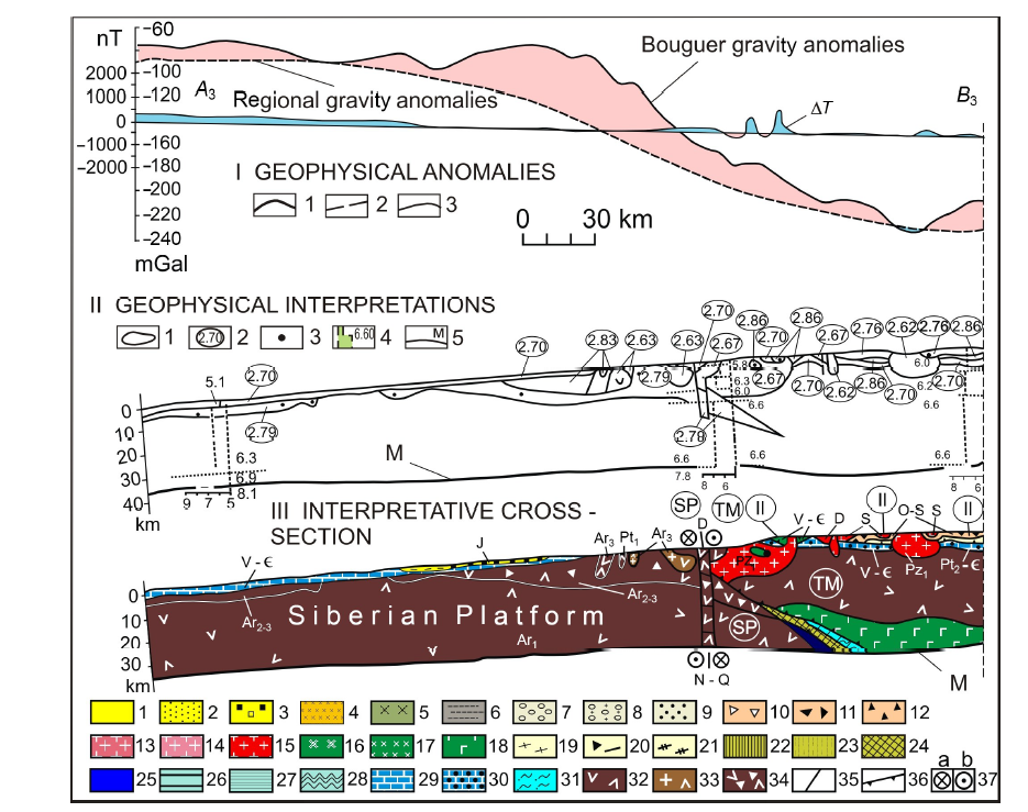
Fig.2 South Siberia-Central Mongolia transect, segment A3-B3 (see Fig.1; modified from Zorin et al.(1993)). I—Geophysical anomalies: 1—Bouguer gravity anomalies; 2—regional gravity anomalies; difference between 1 and 2 is decompensative gravity anomalies reflecting the upper-crust structure; 3—magnetic anomalies (ΔT). II—Geophysical cross section: 1—contours of bodies producing decompensative gravity anomalies; 2—weighted average densities; 3—gravity centers of magnetic bodies; 4—vertical seismic profiles (digits are P wave velocities); 5—Moho discontinuity. Ⅲ—Transect. Rock series of continental rifts (1, 2): 1—Late Cenozoic sediments with basaltic intercalations; 2—Jurassic to Early Cretaceous sediments with basaltic intercalations. Rock series of hot spots (3-5): 3—Early Jurassic bimodal volcanics intercalated with sediments; 4—Early Permian to Triassic alkaline granites; 5—Early Permian to Triassic alkaline basic intrusions. Rock series of orogenic basins (6-9): 6—Jurassic clastics of Siderian Platform margins; 7—Late Paleozoic molasse; 8—Middle Paleozoic molasse; 9—Early Paleozoic molasse. Rock series of magmatic arc, including island arc and active continental margins (10-17); 10—Late Paleozoic volcanic-sedimentary rocks; 11—Middle Paleozoic volcanic and volcanic-sedimentary rocks; 12—Early Paleozoic volcanic and volcanic-sedimentary rocks; 13—Late Paleozoic collision-related felsic intrusions; 14—Middle Paleozoic subduction- and collision-related felsic intrusions; 15—Early Paleozoic subduction- and collision-related felsic intrusions; 16—Late Paleozoic basic and intermediate intrusions; 17—Middle Paleozoic basic and intermediate intrusions; 18—Early Paleozoic basic and intermediate intrusions; 19—Late Paleozoic sediments infilling fore- and back-arc basins; 20—Middle Paleozoic chaotic complex of subduction-accretion wedge; 21—Middle Paleozoic sediments infilling back-arc basins. Ophiolites (22-25): 22—Late Paleozoic; 23—Middle Paleozoic; 24—Late Precambrian to Early Paleozoic; 25—fragments of oceanic crust of uncertain age. Ocean sediments (26-28): 26—Late Paleozoic; 27—Middle Paleozoic; 28—Late Precambrian to Early Paleozoic. Shelf sediments (29-31): 29—Ordovicican to Early Devonian; 30—Vendian to Cambrian; 31—Riphean to Cambrian. Precambrian continental crust (32-34): 32—uncertain in composition; 33—with significant role of granites; 34—with greenstone belts. Tectonic symbols (35-37): 35—normal faults and faults of uncertain geometry; 36—thrust faults; 37—wrench faults (right-lateral). SP—Siberian Platform; TM—Tuva-Mongolia microcontinent.
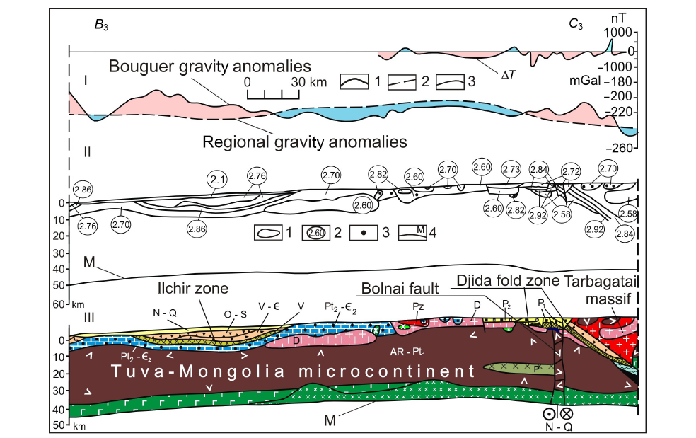
Fig.3 South Siberia-Central Mongolia transect, segment B3-C3 (see Fig.1; modified from Zorin et al.(1993)). For the legend, see Fig.2.
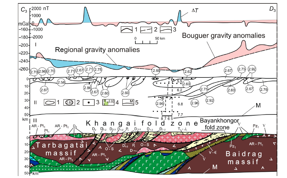
Fig.4 South Siberia-Central Mongolia transect, segment C3-D3 (see Fig.1; modified from Zorin et al.(1993)). For the legend, see Fig.2.
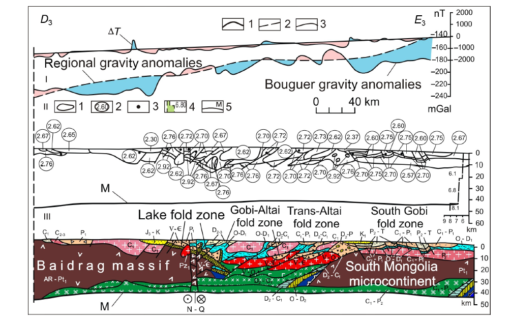
Fig.5 South Siberia-Central Mongolia transect, segment D3-E3 (see Fig.1; modified from Zorin et al.(1993)). For the legend, see Fig.2.

Fig.6 East Siberia transect, segment A1-B1 (see Fig.1; modified from Zorin et al.(1997a)). I—Geophysical anomalies: 1—Bouguer gravity anomalies; 2—regional gravity anomalies; difference between 1 and 2 is decompensative gravity anomalies reflecting the upper-crust structure; 3—magnetic anomalies (ΔT). II—Geophysical cross section: 1—contours of bodies producing decompensative gravity anomalies; 2—weighted average densities; 3—gravity centers of magnetic bodies; 4—vertical seismic profiles (digits are P wave velocities); 5—Moho discontinuity. Ⅲ—Transect. Rocks of continental rifts. Neogenic (Ng) (1, 2): 1—sediments; 2—basalts. Early Cretaceous (K1) (3, 4): 3—sediments; 4—volcanics. Collision-related rocks. Middle-Late Jurassic (5-7): 5—molasse (J2); 6—volcanics ( J 23); 7—granites & granodiorites ( J 23). Early Paleozoic (O-S): 8—granites & granodiorites. Rifean (Rif): 9—granites & granodiorites. Subduction-related rocks (magmatic arcs including subduction wedges, fore-and back-arc basins). Late Permian-Early Jurassic (P2-T & J1) (10-13): 10—marine sediments & volcanics; 11—continental sediments & volcanics; 12—granites & tonalites; 13—mafic intrusives. Late Carboniferous-Early Permian (C2-P1) (14-15): 14—granites & tonalites; 15—mafic intrusives. Devonian-Early Carboniferous (D-C1) (16-19): 16—marine sediments & volcanics; 17—continental sediments & volcanics; 18—granites & tonalites; 19—mafic intrusives. Vendian-Cambrian (V- C) & Vendian-Ordovician (V-O) (20-22): 20—sediments & volcanics; 21—tonalites & granodiorites; 22—mafic intrusives. Rifean (Rif) (23-25): 23—marine sediments & volcanics; 24—tonalites & granodiorites; 25—mafic intrusives. Platforms & microcontinents (26-33): 26—Early Jurassic (J1) passive continental margin; 27—Late Permian-Triassic (P2-T) passive continental margin; 28—Vendian-Ordovician (V-O) & Vendian-Cambrian (V- C) shelf; 29—Rifean (Rif) passive margin; 30—Rifean (Rif) shelf; 31—Early Precambrian (Pt1) crust with significant role of granites; 32—Early Precambrian (AR-Pt1) mainly tonalitic crust; 33—Early Precambrian crust with mafic rocks (AR-Pt1). Tectonic symbols (34-37): 34—normal faults & faults of uncertain geometry; 35—Middle Jurassic thrusts; 36—Ordovician-Silurian thrusts; 37—Rifean thrusts reactivated in Ordovician-Silurian.

Fig.7 East Siberia transect, segment B1-C1 (see Fig.1; modified from Zorin et al.(1997a)). For the legend, see Fig.6.
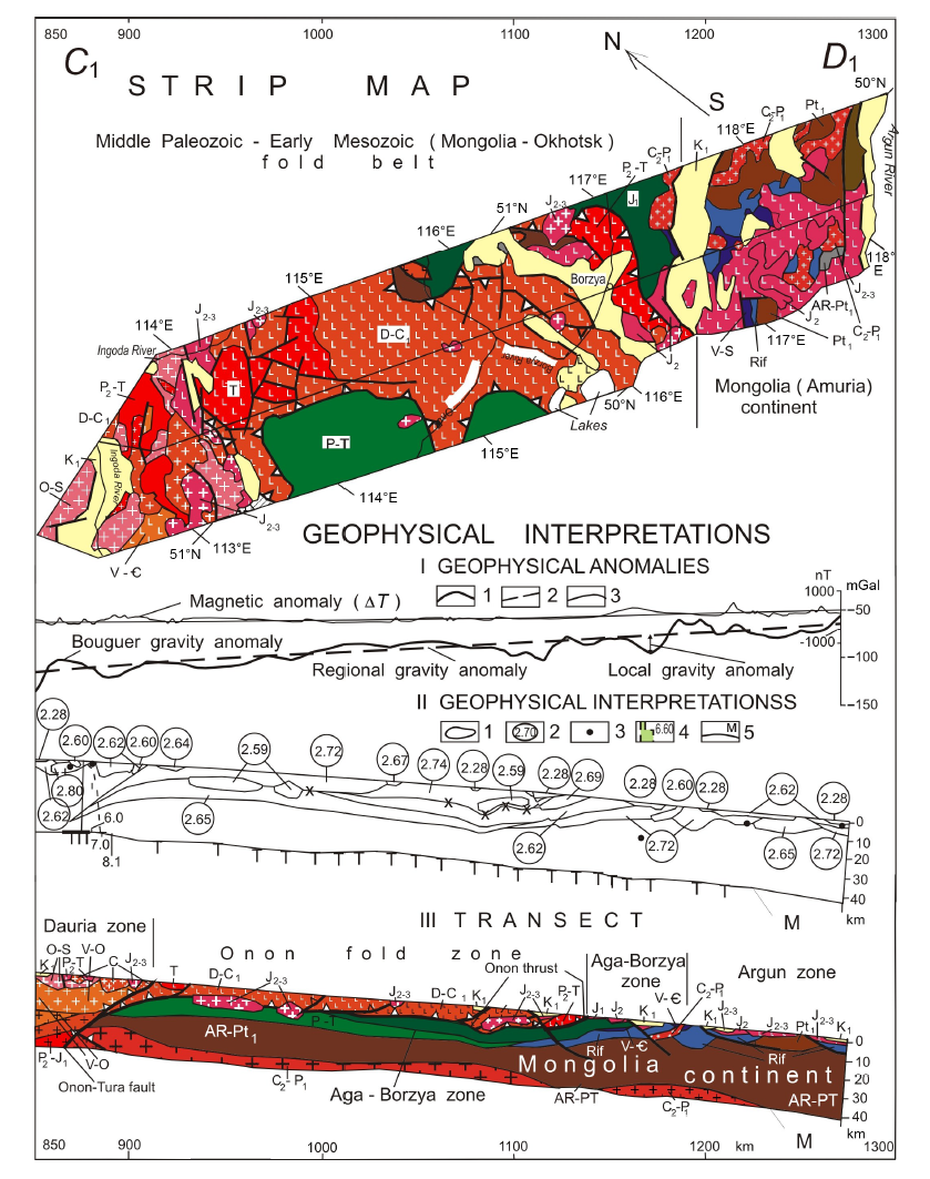
Fig.8 East Siberia transect, segment C1-D1 (see Fig.1; modified from Zorin et al.(1995, 1997b)). For the legend, see Fig.6.
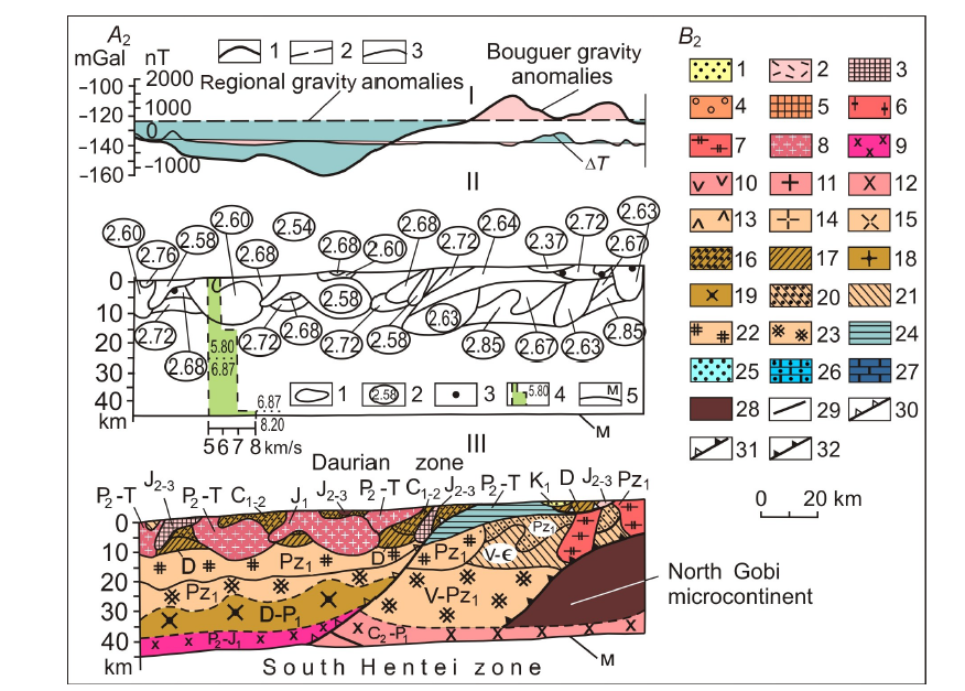
Fig.9 East Mongolia transect, segment A2-B2 (see Fig.1; modified from Zorin et al.(1998)). I—Geophysical anomalies: 1—Bouguer gravity anomalies; 2—regional gravity anomalies; difference between 1 and 2 is decompensative gravity anomalies reflecting the upper-crust structure; 3—magnetic anomalies (ΔT). II—Geophysical cross section: 1—contours of bodies producing decompensative gravity anomalies; 2—weighted average densities; 3—gravity centers of magnetic bodies; 4—vertical seismic profiles (digits are P wave velocities); 5—Moho discontinuity. Ⅲ—Transect. Early Cretaceous formation of continental rift: 1—sediments with effusive-body horizons. Collision-related rocks (2-7). Middle-Late Jurassic collision of Mongolo-China and Siberia (2, 3): 2—volcano-sedimentary sequences; 3—granitoids. Triassic collision of the Mongolian and North-Chinese continents (4, 5): 4—volcano-sedimentary and sedimentary sequences; 5—granitoids. Early Carboniferous collision of the North Gobi microcontinent with South Gobi island arc: 6—granitoids. Ordovician-Silurian collision of island arcs with the North Gobi microcontinent: 7—granitoids. Subduction formations (magmatic-arc series, including those of Andean-type active continental margins, island arcs, trenches, fore- and back-arc basins) (8-23). Late Permian-Early Jurassic subduction beneath the southern part of Siberia (8, 9): 8—granitoids; 9—mafic intrusive rocks. Late Carboniferous-Early Permian subduction beneath the northern part of Mongolia (10-12): 10—volcano-sedimentary sequences; 11—granitoids; 12—mafic intrusive rocks. Middle Carboniferous-Late Permian subduction beneath the southern part of Mongolia (13-15): 13—volcano-sedimentary sequences; 14—granitoids; 15—mafic intrusive rocks. Devonian-Early Permian subduction beneath Siberia, Devonian-Early Carboniferous subduction beneath the Central-Mongolia microcontinent, and Ordovician-Early Carboniferous subduction beneath the South Gobi island arc (16-19): 16—sedimentary sequences; 17—volcano-sedimentary sequences; 18—granitoids; 19—basic intrusive bodies. Vendian-Early Paleozoic subduction beneath the island arcs of the Paleoasian ocean (20-23): 20—sedimentary sequences; 21—volcano-sedimentary sequences; 22—granitoids; 23—mafic intrusive bodies. Formations of continents and microcontinents (24-28): 24—Late Permian-Triassic deposits of the northern passive margin of the Mongolia continent; 25—Late Permian continental deposits; 26—Devonian marine carbonates and clastic deposits; 27—Vendian-Early Paleozoic marine carbonates and clastic deposits; 28—pre-Riphean continental crust. Faults (29-32): 29—normal faults and faults of uncertain geometry; 30—Early Mesozoic thrusts; 31—Middle Paleozoic thrusts; 32—Early Paleozoic thrusts.

Fig.11 East Mongolia transect, segment C2-D2 (see Fig.1; modified from Zorin et al.(1998)). For the legend, see Fig.9.

Fig.10 East Mongolia transect, segment B2-C2 (see Fig.1; modified from Zorin et al.(1998)). For the legend, see Fig.9.
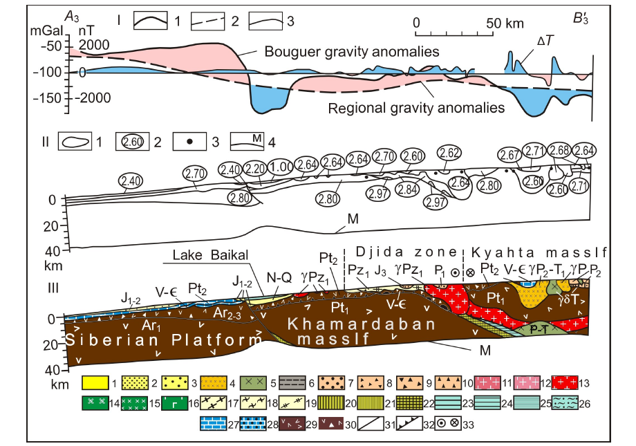
Fig.12 Baikal-Mongolia transect, segment A3-B'3 (see Fig.1; modified from Zorin et al.(1994)). I—Geophysical anomalies: 1—Bouguer gravity anomalies; 2—regional gravity anomalies; difference between 1 and 2 is decompensative gravity anomalies reflecting the upper-crust structure; 3—magnetic anomalies (ΔT). II—Geophysical cross section: 1—contours of bodies producing decompensative gravity anomalies; 2—weighted average densities; 3—gravity centers of magnetic bodies; 4—Moho discontinuity. Ⅲ—Transect. Formations of continental rifts and “hot spots” (1-5): 1—Late Cenozoic clastic deposits with interlayers of basalts; 2—Late Mesozoic clastic and volcanogenic-sedimentary deposits; 3—Late Paleozoic-Early Mesozoic volcanic rocks of the bimodal series with horizons of clastic deposits; 4—Late Paleozoic-Early Mesozoic alkaline granites and syenites; 5—main intrusions of the same age. Formations of foothill and intermountain subsidences of the orogenic stages (6, 7): 6—Jurassic continental deposits of the marginal part of the Siberian Platform; 7—Middle Paleozoic malasses. Formations of magmatic arcs (including island arcs and active margins of continents) (8-19): 8-10—volcanogenic and volcanogenic-sedimentary strata of the Late Paleozoic-Early Mesozoic (8), Middle Paleozoic (9) and Late Proterozoic-Early Paleozoic (10) stages; 11-13—granitoids of the Late Paleozoic-Early Mesozoic (11), Middle Paleozoic (12) and Late Proterozoic-Early Paleozoic (13) stages; 14-16—main and medium intrusions of the Late Paleozoic-Early Mesozoic (14), Middle Paleozoic (15) and Late Proterozoic-Early Paleozoic (16) stages; 17-19—sedimentary deposits of the pre- and back-arc troughs of the Late Paleozoic-Early Mesozoic (17), Middle Paleozoic (18) and Late Proterozoic-Early Paleozoic (19) stages. Oceanic formations (20-25): 20-22—ophiolites of the Late Paleozoic-Early Mesozoic (20), Middle Paleozoic (21) and Late Proterozoic-Early Paleozoic (22) stages; 23-25—deep-water sediments of the Late Paleozoic-Early Mesozoic (23), Middle Paleozoic (24) and Late Proterozoic-Early Paleozoic (25) stages. Offshore formations (26-28): 26—Middle Paleozoic shelf of the Paleotethys; 27—sedimentary cover of the Siberian Platform (Late Proterozoic-Early Paleozoic); 28—sedimentary cover of microcontinent (Late Proterozoic-Early Paleozoic). Precambrian continental crust of the platform and microcontinent (29, 30): 29—not dissected by composition; 30—with significant volumes of main rocks. Faults (31-33): 31—dip-slip faults dip and faults of an undetermined nature; 32—overthrusts; 33—faults (a left-side fault is indicated).

Fig.13 Baikal-Mongolia transect, segment B'3-C'3 (see Fig.1; modified from Zorin et al.(1994)). For the legend, see Fig.12.
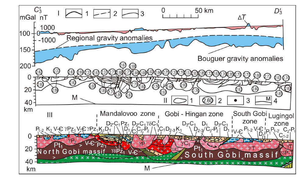
Fig.14 Baikal-Mongolia transect, segment C'3-D'3 (see Fig.1; modified from Zorin et al.(1994)). For the legend, see Fig.12.
| [1] | Argutina T A, Bulavko L F, Bulin N K, et al., 1974. Deep geological structure of the Transbaikalia[J]. Sovetskaya Geologia (1):103-117 (in Russian). |
| [2] | Belichenko V G, Shmotov A P, Sez’ko A I, et al., 1988. Precambrian and Paleozoic evolution of Earth crust (Sayan-Baikal Mountain region)[M]. Novosibirsk: Nauka: 161 (in Russian). |
| [3] | Berzin N A, Dobretsov N L, 1993. Geodynamic evolution of Siberia in Late Precambrian - Early Paleozoic time: reconstruction of the Paleo-Asian ocean[M]. Amsterdam: VSR International Science Pubishers: 45-62. |
| [4] |
Cordell L, Zorin Y A, Keller R, 1991. The decompensative gravity anomaly and deepstructure of the region of the Rio Grande rift[J]. Journal of Geophysical Research, 96(B4):6557-6558.
DOI URL |
| [5] | Dergunov A B, 1989. Caledonides of Central Asia[M]. Moscow: [s.n.]: 191 (in Russian). |
| [6] | Didenko A N, Mossakovskii A A, Pecherskii D M, et al., 1994. Geodynamics of the Paleozoic oceans of the Central Asia[J]. Geologia i Geofizika (7/8):59-75 (in Russian). |
| [7] | Dortman N B, 1984. Physical properties of rocks and mineral resources[M]. Moscow: [s.n.]: 445 (in Russian). |
| [8] | Egorkin A V, Chernikov N M, Danilova Y G, et al., 1980. A regional profile across the northern Asian continent[M]//Zverev S M, Kosminskaya I P. Seismic models of the lithosphere of major geological units on the USSR Territory. Moscow:Nauka:61-67 (in Russian). |
| [9] | Filippova I B, 1969. The Khangay synclinorium: main features of structure and evolution[J]. Geotektonika(5):76-78 (in Russian). |
| [10] | Korostin P V, 1968. Magnetic field of the Baikal area and an essay of its geological interpretation[M]//Belousov V V, Florensov N A. Baikal rift. Moscow: Nauka:131-139 (in Russian). |
| [11] | Kovalenko V I, Yarmoliuk V V, 1990. Evolution of magmatism in geological structures of Mongolia[M]//Zaitsev N S, Kovalenko V I. Evolution of geological processes. Moscow: [s.n.]: 23-55 (in Russian). |
| [12] | Kozhevnikov V M, Antonova L M, Yanovskaya T B, 1990. Horizontal inhomogeneities of the crust and upper mantle beneath the Asian continent according to the data on the surface Rayleigh waves[J]. Izv AN SSSR, Fizika Zemli (3):3-11 (in Russian). |
| [13] | Krylov S V, Mishen’kin B P, Bryksin A V, 1990a. Deep structure of the Baikal rift zone according to the data of multi-waves seismic investigations[M]//Geodynamics of the intracontinental mountainous regions. Novosibirsk:Nauka: 162-169 (in Russian). |
| [14] | Krylov S V, Mandelbaum M M, Seleznev V S, et al., 1990b. Detail deep seismic studies in the Upper Angara area of the Baikal rift zone[J]. Geologia i Geofizika (7):17-27 (in Russian). |
| [15] | Kuznetzov V G, Khrenov P M, 1982. Geological map of Irkutsk region, scale 1∶500000[CM]. Leningrad: VSEGEI: 10 (in Russian). |
| [16] | Mordvinova V V, Zorin Y A, Gao S, et al., 1995. Estimations of the Earth’s crust thickness on the profile Irkutsk-Ulan-Baator-Undurshil according to the spectral ratios of the body seismic waves[J]. Fizika Zemli (9):3-11 (in Russian). |
| [17] | Novoselova M R, 1978. Magnetic anomalies of the Baikal rift zone and adjacent areas[J]. Tectonophysics, 46(1):95-100. |
| [18] | Phinney R A, 1964. Structure of the Earth’s crust from spectral behavior of long-period body waves[J]. Jurnal of Geophysical Research, 69(14):2997-3017. |
| [19] | Pis’mennyi B M, Alakshin A M, Poepeev A V, et al., 1984. Geology and seismicity of the BAM zone[M]. Novosibirsk: Nauka: 172 (in Russian). |
| [20] | Puzyrev N N, 1981. The interior of Baikal from seismic data[M]. Novosibirsk: Nauka: 105 (in Russian). |
| [21] | Rutstein I G, 1992. Geological map of the Chita region, scale 1∶500000[CM]. Moscow: MPGIT: 23. |
| [22] | Ruzhentsev S V, Badarch G, Voznesenskaya T A, 1985. Tectonics of Trans-Altai zone of Mongolia[J]. Geotectonics, 19(4):276-284 (in Russian). |
| [23] | Ruzhentsev S V, Mossakovskiy A A, 1996. Geodynamics and tectonic evolution of the central segments of the Earth[J]. Geotectonics, 29(4):211-311. |
| [24] | Shobogorov P C, 1977. Geological map of Bouriatia, scale 1∶500000[CM]. Leningrad: VSEGEI: 9 (in Russian). |
| [25] | Stepanov P P, Volkhonin V S, 1969. The present-day deep structure of the crust in Mongolia, from geophysical evidence[J]. Sovetskaya Geologia (5):47-63 (in Russian). |
| [26] | Tsyrendorzhiev T T, 1963. Elements of tectonics of the Baikal area, from geophysical data[J]. Geologia and Geofizika (6):60-67 (in Russian). |
| [27] |
Vinnik L P, 1977. Detection of waves converted from P to S in the mantle[J]. Physics of the Earth and Planetary Interiors, 15:39-45.
DOI URL |
| [28] | Zamaraev S M, 1967. Marginal features of the southern Siberian Platform[M]. Moscow: Nauka: 248 (in Russian). |
| [29] | Zonenshain L P, Kus’min M I, Natapov L M, 1990. Tectonics of the lithosphere plates in the USSR area[M]. [S.l.]: Nauka: 326 (in Russian). |
| [30] | Zorin Y A, 1967. On tectonics of the Eastern and Central Trans-Baikal area in the Late Mesozoic[J]. Geotectonika (1):97-108 (in Russian). |
| [31] | Zorin Y A, 1971. The newest structure and isostasy of the Baikal rift zone and adjacent areas[M]. Moscow: Nauka: 168 (in Russian). |
| [32] | Zorin Y A, Novoselova M P, Rogozhina V A, 1982. Deep structure of the Mongolia[M]. Novosibirsk: Nauka: 93 (in Russian). |
| [33] | Zorin Y A, Pis’mennui B M, Novoselova M P, et al., 1985. Decompensative gravity anomalies[J]. Geologiya i Geofizika (8):104-108 (in Russian). |
| [34] | Zorin Y A, Mordvinova V V, Novoselova M P, et al., 1986. Density inhomogeneity of the mantle beneath the Baikal rift[J]. Izv AN SSSR Fizika Zemli (5):43-52 (in Russian). |
| [35] |
Zorin Y A, Kozhevnikov V M, Novoselova M R, et al., 1989. Thickness of the lithosphere beneath the Baikal zone and adjacent regions[J]. Tectonophysics, 168:327-337.
DOI URL |
| [36] |
Zorin Y A, Novoselova M R, Turutanov E K, et al., 1990. Structure of the lithosphere in the Mongolia-Siberian mountainous province[J]. Journal of Geodynamics, 11:327-342.
DOI URL |
| [37] |
Zorin Y A, Belichenko V G, Turutanov E K, et al., 1993. The South Siberia - Central Mongolia transect[J]. Tectonophysics, 225:361-378.
DOI URL |
| [38] | Zorin Y A, Belichenko V G, Turutanov E K, et al., 1994. Baikal-Mongolian transect[J]. Geologia i Geofizika (7/8):94-110 (in Russian). |
| [39] |
Zorin Y A, Belichenko V G, Turutanov E K, et al., 1995. The East Siberia transect[J]. International Geology Review, 37(2):154-175.
DOI URL |
| [40] | Zorin Y A, Belichenko V G, Logachev N A, et al., 1996. Paleogeodynamics of the central Asia[M]//Lithosphere of the central Asia. Novosibirsk:Nauka:9-16 (in Russian). |
| [41] | Zorin Y A, Belichenko V G, Turutanov E K, et al., 1997a. Earth’s crust structure and geodynamics of the Baikal fold area[J]. Otechestvennaya Geologiya (10):37-44 (in Russian). |
| [42] | Zorin Y A, Belichenko V G, Turutanov E K, et al., 1997b. Earth’s crust structure and geodynamics of the western part of Mongolia-Okhotsk belt[J]. Otechestvennaya Geologia (11):52-58 (in Russian). |
| [43] | Zorin Y A, Belichenko V G, Turutanov E K, et al., 1998. The terreins of the Eastern Mongolia and Central Transbaikalia and evolution of Mongolo-Okhotsk fold beld[J]. Geologiya i Geofisika, 39(1):11-25 (in Russian). |
| [44] |
Zorin Y A, Mordvinova V V, Turutanov E K, et al., 2002. Low seismic velocity layers in the Earth’s crust beneath Eastern Siberia (Russia) and Central Mongolia: receiver function data and their possible geological implication[J]. Tectonophysics, 359:307-327.
DOI URL |
| [45] | Zorin Y A, Turutanov E K, Mordvinova V V, et al., 2004. Complex geophysical and seismological investigations in Mongolia[M]. Ulanbaatar-Irkutsk: Institute of Earth Crust SD Russian AS: 33-50. |
| [46] | Zverev S M, Kos’minskaya I P, 1980. Seismic models of the main geostructures of the USSR[M]. Moscow: Nauka: 183 (in Russian). |
| [1] | MO Tian-Feng. Discussion on some important problems in structural geology and tectonics. [J]. Earth Science Frontiers, 20140101, 21(1): 132-149. |
| [2] | XIA Teng, ZHANG Jiaming, LI Shupeng, GUO Lili, WANG Qi, MAO Deqiang. Geophysical dynamic monitoring and analysis of in-situ remediation process at organic contaminated sites [J]. Earth Science Frontiers, 2024, 31(3): 432-442. |
| [3] | LI Dan, CHANG Jian, QIU Nansheng, XIONG Yujie. Thermal analysis of ultra-deep layers and its influence on reservoir utilization in platform area, Tarim Basin [J]. Earth Science Frontiers, 2023, 30(6): 135-149. |
| [4] | ZHANG Qi, ZHAI Mingguo, WEI Chunjing, ZHOU Ligang, HUANG Guangyu, CHEN Wanfeng, JIAO Shoutao, TANG Jun, LIU Rui, YUAN Jie, WANG Zhen, WANG Yue, YUAN Fanglin. A new granitization theory: Discussion on the four-stage granitization theory [J]. Earth Science Frontiers, 2023, 30(6): 406-435. |
| [5] | WANG Ying, DING Xiaozhong, HAN Kunying, CHEN Jian, LIU Jingwen, LU Tianqi, WANG Juntao, SHI Chenglong, JIN Ming, PANG Jianfeng. Geological characteristics and evolution of the Schrödinger basin and adjacent areas: Insights from multi-source remote sensing data [J]. Earth Science Frontiers, 2023, 30(4): 525-538. |
| [6] | JIAO Shoutao, ZHANG Qi, TANG Jun, YUAN Jie, WANG Zhen, CHEN Wanfeng, CAI Hongming, WANG Yue. Quantum Science and Big Data: Two powerful tools that drive rapid advancements in geology [J]. Earth Science Frontiers, 2023, 30(3): 294-307. |
| [7] | LIU Rui, ZUO Lei, ZHANG Peng, ZHAO Zongchao, TAO Gang, WANG Kun, TAO Dongping. Nanogeology brings quantum science to geology [J]. Earth Science Frontiers, 2023, 30(3): 308-312. |
| [8] | XIA Xueqi, JI Junfeng, YANG Zhongfang, LU Xinzhe, HUANG Chunlei, WEI Yingchun, XU Changyan, LIANG Zhuoying. Parent rock type control on cadmium background in soil and sediment: An example from Guizhou Province [J]. Earth Science Frontiers, 2022, 29(4): 438-447. |
| [9] | WEN Dongguang, SONG Jian, DIAO Yujie, ZHANG Linyou, ZHANG Fucun, ZHANG Senqi, YE Chengming, ZHU Qingjun, SHI Yanxin, JIN Xianpeng, JIA Xiaofeng, LI Shengtao, LIU Donglin, WANG Xinfeng, YANG Li, MA Xin, WU Haidong, ZHAO Xueliang, HAO Wenjie. Opportunities and challenges in deep hydrogeological research [J]. Earth Science Frontiers, 2022, 29(3): 11-24. |
| [10] | FENG Yanfang, LIU Jiangtao, LIU Yong, CUI Xianyue, SI Xiaobo. Updating basic geological data: Current status at home and abroad and suggestions for future improvements [J]. Earth Science Frontiers, 2022, 29(2): 370-377. |
| [11] | Valentina V. MORDVINOVA, Maria A. KHRITOVA, Elena A. KOBELEVA, Mikhail M. KOBELEV, Evgeniy Kh. TURUTANOV, Victor S. KANAYKIN. Detailed structure of the Earth’s crust and upper mantle of the Severomuysk segment of the Baikal rift zone according to teleseismic data [J]. Earth Science Frontiers, 2022, 29(2): 378-392. |
| [12] | LIU Yong, LI Tingdong, XIAO Qinghui, ZHANG Kexin, ZHU Xiaohui, DING Xiaozhong. Progress in geological study of oceanic plates [J]. Earth Science Frontiers, 2022, 29(2): 79-93. |
| [13] | YANG Xiaoping, ZHONG Hui, YANG Yajun, JIANG Bing, QIAN Cheng, MA Yongfei, ZHANG Chao. Research progress on the subduction-accretion complex: Reconstruction of the tectonic framework of the Great Xing’an Range [J]. Earth Science Frontiers, 2022, 29(2): 94-114. |
| [14] | ZHANG Dingding, ZHANG Heng. The exhumation mechanism of eclogites in continental orogenic belts: Metamorphic petrology and geophysical constraints [J]. Earth Science Frontiers, 2022, 29(1): 303-315. |
| [15] | ZHAO Junmeng, ZHANG Peizhen, ZHANG Xiankang, Xiaohui YUAN, Rainer KIND, Robert van der HILST, GAN Weijun, SUN Jimin, DENG Tao, LIU Hongbing, PEI Shunping, XU Qiang, ZHANG Heng, JIA Shixu, YAN Maodu, GUO Xiaoyu, LU Zhanwu, YANG Xiaoping, DENG Gong, JU Changhui. Crust-mantle structure and geodynamic processes in western China and their constraints on resources and environment: Research progress of the ANTILOPE Project [J]. Earth Science Frontiers, 2021, 28(5): 230-259. |
| Viewed | ||||||
|
Full text |
|
|||||
|
Abstract |
|
|||||