Earth Science Frontiers ›› 2021, Vol. 28 ›› Issue (4): 142-152.DOI: 10.13745/j.esf.sf.2020.10.15
Previous Articles Next Articles
ZHANG Junjie1( ), BAI Zhongke1,2,3,*(), YANG Boyu1
Received:2020-09-29
Revised:2020-11-22
Online:2021-07-25
Published:2021-07-25
Contact:
BAI Zhongke
CLC Number:
ZHANG Junjie, BAI Zhongke, YANG Boyu. Gravel curtain layer in the desert open-pit mining area of Xinjiang: Ecological damage and reconstruction method[J]. Earth Science Frontiers, 2021, 28(4): 142-152.
| 序号 | 煤矿分布 | 建设地点 | 生产规模/(104 t·a-1) | 矿型 |
|---|---|---|---|---|
| 1 | 新疆准东煤田五彩湾矿区三号露天煤矿 | 新疆 昌吉回族自治州 | 2 000 | 特大型 |
| 2 | 红沙泉一号露天煤矿 | 新疆 昌吉回族自治州 | 1 000 | 大型 |
| 3 | 新疆准东煤田吉木萨尔县南露天煤矿(帐篷沟)一期工程 | 新疆 昌吉回族自治州 | 1 000 | 大型 |
| 4 | 新疆西黑山矿区将军戈壁二号露天煤矿一期工程 | 新疆 昌吉回族自治州 | 1 000 | 大型 |
| 5 | 新疆广汇新能源有限公司白石湖露天煤矿 | 新疆 哈密 | 800 | 大型 |
| 6 | 新疆昌吉英格玛煤电投资有限责任公司奇台西黑山露天煤矿 | 新疆 昌吉回族自治州 | 600 | 中型 |
| 7 | 国网能源哈密煤电有限公司大南湖二号露天煤矿 | 新疆 哈密 | 300 | 中型 |
Table 1 Basic informaton on the seven typical opencast coal mines in the northwest desert area
| 序号 | 煤矿分布 | 建设地点 | 生产规模/(104 t·a-1) | 矿型 |
|---|---|---|---|---|
| 1 | 新疆准东煤田五彩湾矿区三号露天煤矿 | 新疆 昌吉回族自治州 | 2 000 | 特大型 |
| 2 | 红沙泉一号露天煤矿 | 新疆 昌吉回族自治州 | 1 000 | 大型 |
| 3 | 新疆准东煤田吉木萨尔县南露天煤矿(帐篷沟)一期工程 | 新疆 昌吉回族自治州 | 1 000 | 大型 |
| 4 | 新疆西黑山矿区将军戈壁二号露天煤矿一期工程 | 新疆 昌吉回族自治州 | 1 000 | 大型 |
| 5 | 新疆广汇新能源有限公司白石湖露天煤矿 | 新疆 哈密 | 800 | 大型 |
| 6 | 新疆昌吉英格玛煤电投资有限责任公司奇台西黑山露天煤矿 | 新疆 昌吉回族自治州 | 600 | 中型 |
| 7 | 国网能源哈密煤电有限公司大南湖二号露天煤矿 | 新疆 哈密 | 300 | 中型 |

Fig.1 Gravel curtain layer sampling in opencast coal mines
| 露天矿区名称 | 遥感影像数据 | 卫星过境时间 |
|---|---|---|
| 五彩湾 | GF-2 | 2017-07 |
| 红沙泉 | GF-2 | 2017-07 |
| 西黑山 | GF-2 | 2015-10 |
| 将军戈壁 | GF-2 | 2015-10 |
| 白石湖 | GF-2 | 2017-10 |
| 大南湖 | GF-2 | 2017-07 |
| 伊犁 | GF-2 | 2017-07 |
| 五彩湾 | landsat7 | 2000-08 |
| 五彩湾 | landsatTM | 2005-09 |
| 五彩湾 | landsatTM | 2010-08 |
| 五彩湾 | langsat8 | 2015-09 |
| 五彩湾 | landsat7 | 2000-09 |
| 五彩湾 | landsatTM | 2005-08 |
| 五彩湾 | landsatTM | 2010-09 |
| 五彩湾 | landsat8 | 2017-08 |
Table 2 List of remote sensing image collections for the environmental restoration in the northwest desert mining area
| 露天矿区名称 | 遥感影像数据 | 卫星过境时间 |
|---|---|---|
| 五彩湾 | GF-2 | 2017-07 |
| 红沙泉 | GF-2 | 2017-07 |
| 西黑山 | GF-2 | 2015-10 |
| 将军戈壁 | GF-2 | 2015-10 |
| 白石湖 | GF-2 | 2017-10 |
| 大南湖 | GF-2 | 2017-07 |
| 伊犁 | GF-2 | 2017-07 |
| 五彩湾 | landsat7 | 2000-08 |
| 五彩湾 | landsatTM | 2005-09 |
| 五彩湾 | landsatTM | 2010-08 |
| 五彩湾 | langsat8 | 2015-09 |
| 五彩湾 | landsat7 | 2000-09 |
| 五彩湾 | landsatTM | 2005-08 |
| 五彩湾 | landsatTM | 2010-09 |
| 五彩湾 | landsat8 | 2017-08 |
| 编号 | 草场类型 | 优势种 | 面积/km2 | 地理位置 | 生物量/ (g·m-2·a-1) | ||
|---|---|---|---|---|---|---|---|
| 地点 | 经度 | 纬度 | |||||
| 1 | 梭梭柴荒漠 | 梭梭柴、沙拐枣+杂类草 | 240 | 研究区东侧 | 89°07'49″E | 44°50'39″N | 13.62 |
| 2 | 梭梭柴荒漠 | 梭梭柴、沙拐枣+杂类草 | 240 | 研究区西侧 | 89°16'00″E | 44°50'00″N | 11.44 |
Table 3 Statistical table of grassland biomass monitoring sites in the study area
| 编号 | 草场类型 | 优势种 | 面积/km2 | 地理位置 | 生物量/ (g·m-2·a-1) | ||
|---|---|---|---|---|---|---|---|
| 地点 | 经度 | 纬度 | |||||
| 1 | 梭梭柴荒漠 | 梭梭柴、沙拐枣+杂类草 | 240 | 研究区东侧 | 89°07'49″E | 44°50'39″N | 13.62 |
| 2 | 梭梭柴荒漠 | 梭梭柴、沙拐枣+杂类草 | 240 | 研究区西侧 | 89°16'00″E | 44°50'00″N | 11.44 |
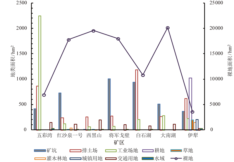
Fig.2 Land types and areas of each land type and bare land in the seven opencast coal mines in the northwest desert area
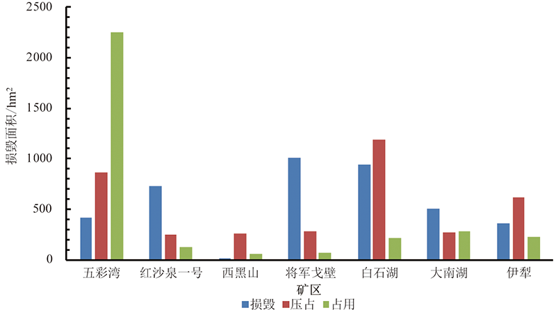
Fig.3 Area of land damage in the seven typical opencast mines in the northwest desert area
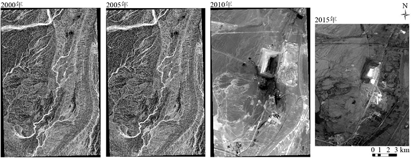
Fig.4 Historical NDVI images (2000-2015) of the Wucaiwan mining area
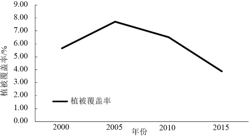
Fig.5 Vegetation coverage of the Wucaiwan mining area during 2000-2015

Fig.6 Gravel cover distribution map of the Wucaiwan mining area
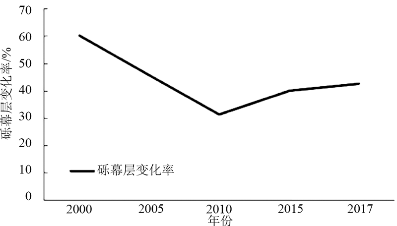
Fig.7 Interannual variation in gravel cover in the Wucaiwan mining area
| [1] | 白中科, 周伟, 王金满, 等. 再论矿区生态系统恢复重建[J]. 中国土地科学, 2018, 32(11):1-9. |
| [2] | 白中科, 杨侨, 白甲林. 论绿色矿山建设的源头管控与过程监管[J]. 中国矿业, 2018, 27(8):75-79. |
| [3] | 贺佑国, 叶旭东, 王震. 关于煤炭工业“十三五”规划的思考[J]. 煤炭经济研究, 2015, 35(1):6-8, 21. |
| [4] |
HILSON G. Defining “cleaner production” and “pollution prevention” in the mining context[J]. Minerals Engineering, 2003, 16(4):305-321.
DOI URL |
| [5] | 赵鑫. 基于RS、GIS的哈密三道岭矿区生态环境调查与评价[D]. 西安: 西安科技大学, 2013. |
| [6] |
TOWNS D R, BALLANTINE W J. Conservation and restoration of New Zealand Island ecosystems[J]. Trends in Ecology & Evolution, 1993, 8(12):452-457.
DOI URL |
| [7] | 卞正富, 许家林, 雷少刚. 论矿山生态建设[J]. 煤炭学报, 2007, 32(1):13-19. |
| [8] | 卞正富, 雷少刚, 金丹, 等. 矿区土地修复的几个基本问题[J]. 煤炭学报, 2018, 43(1):190-197. |
| [9] | 胡振琪. 我国土地复垦与生态修复30年: 回顾、反思与展望[J]. 煤炭科学技术, 2019, 47(1):25-35. |
| [10] | 徐良骥, 黄璨, 章如芹, 等. 煤矸石充填复垦地理化特性与重金属分布特征[J]. 农业工程学报, 2014, 30(5):211-219. |
| [11] | 孙绍先, 李树志. 我国煤矿土地复垦和塌陷区综合治理的发展与技术途径[J]. 矿山测量, 1991, 19(1):34-38, 63. |
| [12] | 胡振琪, 位蓓蕾, 林衫, 等. 露天矿上覆岩土层中表土替代材料的筛选[J]. 农业工程学报, 2013, 29(19):209-214. |
| [13] | BRADSHAW A D, CHADWICK M J. The restoration of land: the ecology and reclamation of derelict and degraded land[M]. Oxford: Blackwell Scientific Publications, 1980. |
| [14] | 宋锐涛. 不同生态恢复与重建措施下的物种多样性与土壤特征: 以长汀县河田地区为例[D]. 福州: 福建师范大学, 2013. |
| [15] | 温晓丽. 宝日希勒矿区生态环境恢复与治理技术研究[J]. 内蒙古煤炭经济, 2016(8):63-65. |
| [16] | 吴历勇. 煤矿区生态恢复理论与技术研究进展[J]. 矿产保护与利用, 2012(4):54-58. |
| [17] | 常秋玲, 康鸳鸯. 河南采煤塌陷区土地复垦与生态恢复浅析[J]. 中国矿业, 2006, 15(11):43-45. |
| [18] | 魏艳, 侯明明, 王宏镔, 等. 矿业废弃地的生态恢复与重建研究[J]. 矿业快报, 2006, 22(11):36-39. |
| [19] | 白中科, 赵景逵, 李晋川, 等. 大型露天煤矿生态系统受损研究: 以平朔露天煤矿为例[J]. 生态学报, 1999, 19(6):870-875. |
| [20] | 李树志. 我国采煤沉陷土地损毁及其复垦技术现状与展望[J]. 煤炭科学技术, 2014, 42(1):93-97. |
| [21] | 杜建平, 邵景安, 周春蓉, 等. 基于生态适宜度和三角模型的煤矿临时建设用地复垦决策研究[J]. 自然资源学报, 2018, 33(11):1872-1885. |
| [22] | 刘士余, 孟菁玲, 张成梁. 山西煤矿区土地荒漠化类型和成因分析[J]. 水土保持研究, 2006, 13(5):163-165. |
| [23] | 裘品姬. 新疆煤炭行业“十三五”发展的思考与建议[J]. 煤炭经济研究, 2015, 35(1):14-21. |
| [24] | 秦伟, 朱清科, 张学霞, 等. 植被覆盖度及其测算方法研究进展[J]. 西北农林科技大学学报(自然科学版), 2006, 34(9):163-170. |
| [25] |
AHIRWAL J, MAITI S K. Development of Technosol properties and recovery of carbon stock after 16 years of revegetation on coal mine degraded lands, India[J]. Catena, 2018, 166:114-123.
DOI URL |
| [26] | FENG Y, WANG J M, BAI Z K, et al. Effects of surface coal mining and land reclamation on soil properties: a review[J]. Earth-Science Reviews, 2019, 191:12-25. |
| [27] |
DOMINATI E, PATTERSON M, MACKAY A. A framework for classifying and quantifying the natural capital and ecosystem services of soils[J]. Ecological Economics, 2010, 69(9):1858-1868.
DOI URL |
| [28] | UPADHYAY N, VERMA S, SINGH A P, et al. Soil ecophysiological and microbiological indices of soil health: a study of coal mining site in Sonbhadra, Uttar Pradesh[J]. Journal of Soil Science and Plant Nutrition, 2016, 16(3):778-800. |
| [29] |
申元村, 王秀红, 程维明, 等. 中国戈壁综合自然区划研究[J]. 地理科学进展, 2016, 35(1):57-66.
DOI |
| [30] | 王健铭, 董芳宇, 巴海·那斯拉, 等. 中国黑戈壁植物多样性分布格局及其影响因素[J]. 生态学报, 2016, 36(12):3488-3498. |
| [31] |
GUNIN P D, DEDKOV V P, DANZHALOVA E V, et al. NDVI for monitoring of the state of steppe and desert ecosystems of the Gobi[J]. Arid Ecosystems, 2019, 9(3):179-186.
DOI URL |
| [32] | YU K F, LEHMKUHL F, SCHLÜTZ F, et al. Late Quaternary environments in the Gobi Desert of Mongolia: vegetation, hydrological, and palaeoclimate evolution[J]. Palaeogeography, Palaeoclimatology, Palaeoecology, 2019, 514:77-91. |
| [33] |
MU Y, WANG F, ZHENG B Y, et al. McGET: a rapid image-based method to determine the morphological characteristics of gravels on the Gobi desert surface[J]. Geomorphology, 2018, 304:89-98.
DOI URL |
| [34] | 王金满, 白中科, 崔艳, 等. 干旱戈壁荒漠矿区破坏土地生态化复垦模式分析[J]. 资源与产业, 2010, 12(2):83-88. |
| [35] | 冯益明, 吴波, 周娜, 等. 基于遥感影像识别的戈壁分类体系研究[J]. 中国沙漠, 2013, 33(3):635-641. |
| [36] | 赵廷宁, 张玉秀, 曹兵, 等. 西北干旱荒漠区煤炭基地生态安全保障技术[J]. 水土保持学报, 2018, 32(1):1-5. |
| [37] | 张诗吟. 准东露天煤矿排土场植被恢复的研究[D]. 乌鲁木齐: 新疆大学, 2017. |
| [38] | 吴煜. 新疆干旱荒漠区煤矿开采区域的水土保持措施探讨[J]. 中国水土保持, 2017(6):33-35. |
| [39] | 李苗苗. 植被覆盖度的遥感估算方法研究[J]. 北京: 中国科学院研究生院(遥感应用研究所), 2003. |
| [40] | 杨超, 邬国锋, 李清泉, 等. 植被遥感分类方法研究进展[J]. 地理与地理信息科学, 2018, 34(4):24-32. |
| [41] | 康萨如拉, 牛建明, 张庆, 等. 草原区矿产开发对景观格局和初级生产力的影响: 以黑岱沟露天煤矿为例[J]. 生态学报, 2014, 34(11):2855-2867. |
| [42] | 季方. 塔里木盆地荒漠类型及其抗风蚀特征初探[J]. 水土保持学报, 2001, 15(1):16-18, 53. |
| [43] | 雷文进, 顾国安. 中国土壤系统分类中干旱土分类的修订说明[J]. 土壤, 1996, 28(5):232-236. |
| [1] | HE Hui, MU Wenping, ZHANG Xiao, SONG Yubing, LÜ Yuanyang, WU Xiong, YE Baoying, BAI Zhongke. Spatio-temporal evolution evaluation of geological environment of large open-pit coal mine areas in Xilin Gol league [J]. Earth Science Frontiers, 2024, 31(3): 443-457. |
| [2] | WEI Hongbin, LUO Ming, ZHANG Shiwen, ZHOU Pengfei. Effects of different remediation treatments on heavy metals and microorganisms in mining wasteland [J]. Earth Science Frontiers, 2023, 30(5): 541-552. |
| [3] | MAO Long, WANG Shenglan, QIU Xiaoyi, TAO Zhuolin, FENG Yongzhong, HUANG Yinzhou. Evaluation of ecological resilience in terrestrial ecosystems in Gansu, China-an empirical study [J]. Earth Science Frontiers, 2023, 30(4): 504-513. |
| [4] | ZHAO Bingqing, BAI Zhongke, GUO Donggang, CAO Yingui. The undergrowth developmental dynamics of plantations in an open-pit coal mine waste dump in loess area [J]. Earth Science Frontiers, 2021, 28(4): 153-164. |
| [5] | LUO Ming, ZHANG Shiwen, WEI Hongbin, ZHOU Pengfei, ZHOU Yan, CHEN Yan, LI Zhuochao, ZHANG Jintao. Ecological restoration of the Dabaoshan Mine based on IUCN biodiversity management guidelines [J]. Earth Science Frontiers, 2021, 28(4): 90-99. |
| [6] | CAI Haisheng, ZHA Dongping, ZHANG Xueling, CHEN Yi, ZENG Heng, SHAO Hui, HONG Tulin. Territorial land zoning for ecological restoration in Jiangxi Province based on dominant ecological function [J]. Earth Science Frontiers, 2021, 28(4): 55-69. |
| [7] | LIU Yunhui, YU Zhenrong, LUO Ming. Strategies for biodiversity conservation in agricultural landscape during land rehabilitation and ecological restoration [J]. Earth Science Frontiers, 2021, 28(4): 48-54. |
| [8] | YANG Chongyao, ZHOU Yan, CHEN Yan, WANG Liwei. Ecosystem conservation and restoration through Nature-based Solutions [J]. Earth Science Frontiers, 2021, 28(4): 25-34. |
| [9] | ZHOU Yan, CHEN Yan, YING Lingxiao, YANG Chongyao. A technical framework for ecosystem conservation and restoration [J]. Earth Science Frontiers, 2021, 28(4): 14-24. |
| [10] | BAI Zhongke. The major issues in ecological restoration of China’s territorial space [J]. Earth Science Frontiers, 2021, 28(4): 1-13. |
| [11] | YANG Ke, JIANG Jian-Jun, LIU Fei, BAI Zhong-Ke. Polycyclic aromatic hydrocarbons (PAHs) in the topsoils of typical reclaimed area in Pingshuo opencast coal mine: Status, sources and risk. [J]. Earth Science Frontiers, 2016, 23(5): 281-290. |
| Viewed | ||||||
|
Full text |
|
|||||
|
Abstract |
|
|||||