地学前缘 ›› 2026, Vol. 33 ›› Issue (1): 1-13.DOI: 10.13745/j.esf.sf.2025.10.5
文章1( ), 李一鸣2, 郭绪磊1, 万坦1, 罗清树3, 周宏3
收稿日期:2025-09-30
修回日期:2025-10-15
出版日期:2026-11-25
发布日期:2025-11-10
作者简介:文 章(1982—),男,博士,教授,博士生导师,主要从事地下水流及溶质运移数值模拟工作。E-mail: wenz@cug.edu.cn
基金资助:
WEN Zhang1(), LI Yiming2, GUO Xulei1, WAN Tan1, LUO Qingshu3, ZHOU Hong3
Received:2025-09-30
Revised:2025-10-15
Online:2026-11-25
Published:2025-11-10
摘要:
地表水-地下水交互是流域水循环与物质迁移的关键过程,其机制取决于河岸带含水层结构与水动力特征的精细刻画。现有研究多聚焦于沉积河岸带,而岩溶裂隙河岸带因介质非均质性与流动路径复杂性,其交互机制仍存在认知空白。本研究以葛洲坝库区南岸典型裂隙河岸带为靶区,通过钻孔监测网络解析地下水对长江水位波动的响应模式,并构建三维基岩裂隙-溶蚀宽大裂隙耦合数值模型,定量刻画双层裂隙含水系统的水量交换过程。主要结论如下:(1)研究区地下水赋存体系为双层裂隙含水层系统复合3条宽大裂隙密集带。地下水动态受长江水位的调控较为明显;(2)深层含水层排泄量大于浅层含水层;(3)宽大裂隙是地下水赋存迁移以及与长江进行水量交换的主要通道,其排泄量比基岩裂隙含水层高3个量级;(4)宽大裂隙是浅、深层裂隙含水层之间水量交换的主要通道。本研究定量刻画了裂隙河岸带双层裂隙-岩溶耦合系统的交互通量与通道效应,为基岩区河岸带水资源精细管理和长江大保护提供了可直接落地的科学依据与技术范式。
中图分类号:
文章, 李一鸣, 郭绪磊, 万坦, 罗清树, 周宏. 葛洲坝库区裂隙河岸地表水-地下水交互特征[J]. 地学前缘, 2026, 33(1): 1-13.
WEN Zhang, LI Yiming, GUO Xulei, WAN Tan, LUO Qingshu, ZHOU Hong. Characteristics of surface water-groundwater interaction in the fractured riverbank of the Gezhouba Reservoir area[J]. Earth Science Frontiers, 2026, 33(1): 1-13.

图1 研究区地层概况及钻孔示意图
Fig.1 Stratigraphic framework and borehole profile of the study area

图2 钻孔结构柱状图、水文地质描述、岩心成像记录、岩心编录以及测井结果 (a)ZK08;(b)ZK09。图中蓝色框线为主要出水段位置。
Fig.2 Borehole lithological columns, hydrogeological descriptions, core imaging records, core logging data, and well-logging results: (a) ZK08; (b) ZK09. The blue boxes indicate the main water-bearing (aquifer) sections.
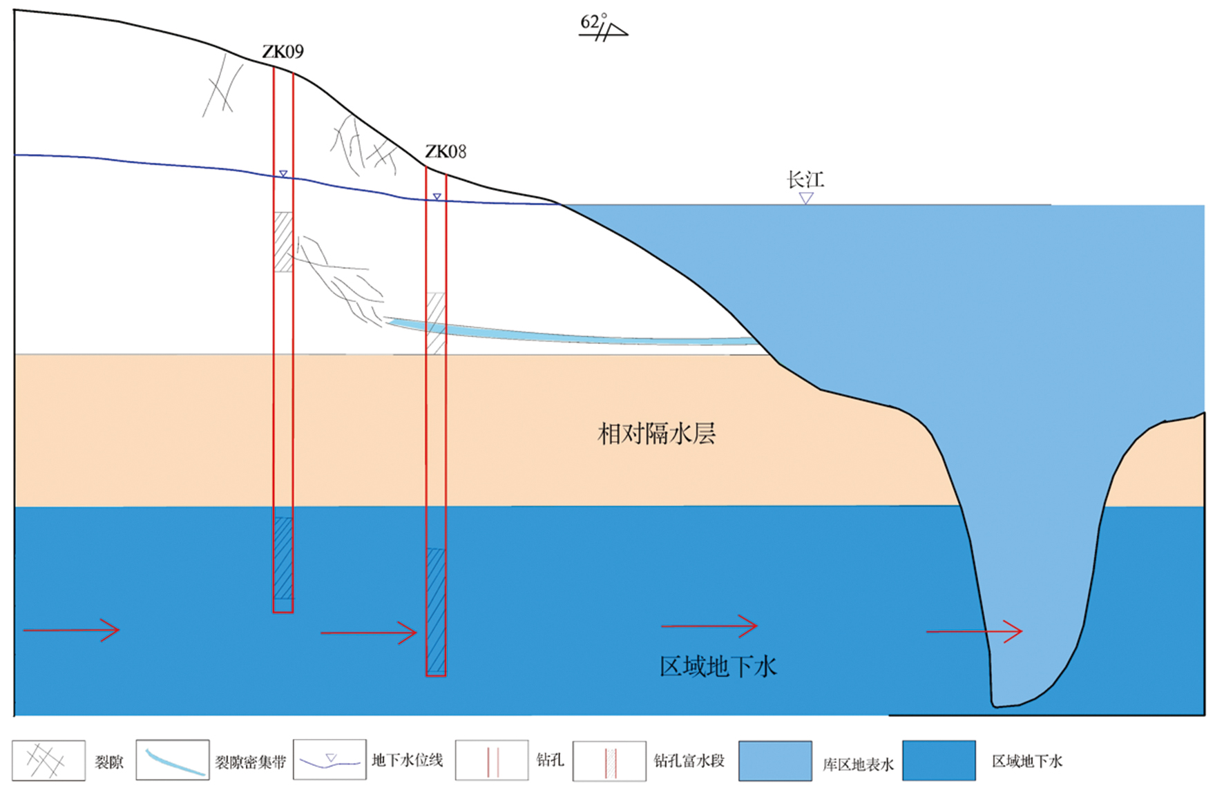
图3 地下水赋存模式示意图
Fig.3 Schematic diagram of groundwater occurrence
| 裂隙编号 | 深度/m | 介质充填情况 | 岩性 | 倾向/(°) | 倾角/(°) | 隙宽/m | |
|---|---|---|---|---|---|---|---|
| ZK09 | 1 | 49 | 无充填 | 粗晶白云岩 | 50 | 85 | 0.1 |
| 2 | 11 | 无充填 | 粗晶白云岩 | 307 | 76 | 0.03 | |
| 3 | 78.4 | 无充填 | 粗晶白云岩 | 83 | 70 | 0.08 | |
| ZK08 | 1 | 32.7 | 局部泥质充填 | 粗晶白云岩 | 48 | 86 | 0.1 |
| 2 | 20.3 | 局部泥质充填 | 粗晶白云岩 | 312 | 70 | 0.03 | |
| 3 | 44.5 | 局部方解石充填 | 粗晶白云岩 | 89 | 73 | 0.08 |
表1 3条大裂隙坐标信息及发育情况
Table 1 Coordinates and characteristics of the three major fractures
| 裂隙编号 | 深度/m | 介质充填情况 | 岩性 | 倾向/(°) | 倾角/(°) | 隙宽/m | |
|---|---|---|---|---|---|---|---|
| ZK09 | 1 | 49 | 无充填 | 粗晶白云岩 | 50 | 85 | 0.1 |
| 2 | 11 | 无充填 | 粗晶白云岩 | 307 | 76 | 0.03 | |
| 3 | 78.4 | 无充填 | 粗晶白云岩 | 83 | 70 | 0.08 | |
| ZK08 | 1 | 32.7 | 局部泥质充填 | 粗晶白云岩 | 48 | 86 | 0.1 |
| 2 | 20.3 | 局部泥质充填 | 粗晶白云岩 | 312 | 70 | 0.03 | |
| 3 | 44.5 | 局部方解石充填 | 粗晶白云岩 | 89 | 73 | 0.08 |
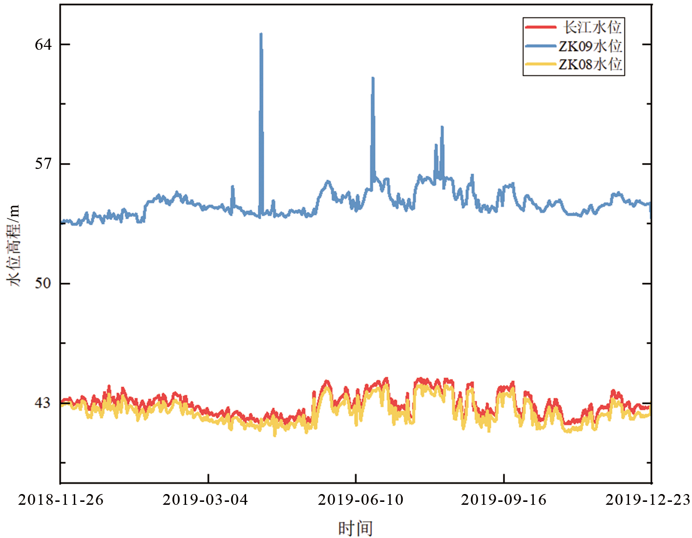
图4 长江、ZK08和ZK09水位变化图
Fig.4 Temporal variations in water levels of the Yangtze River, ZK08, and ZK09

图5 模拟场区示意图(蓝色为模拟区域,红色为钻孔位置)
Fig.5 Schematic diagram of the simulated field area (blue indicates the simulation domain, and red marks the well locations)

图6 含水层刻画示意图
Fig.6 Schematic diagram of aquifer characterization

图7 裂隙分布示意图 a—裂隙1;b—裂隙2;c—裂隙3。
Fig.7 Schematic diagram showing the distribution of fractures
| 描述 | 符号 | 值 |
|---|---|---|
| 浅层含水层渗透系数 | K1 | 1×10⁻³ m/d |
| 浅层含水层孔隙度 | θ1 | 0.2 |
| 深层含水层渗透系数 | K2 | 1×10⁻² m/d |
| 深层含水层孔隙度 | θ2 | 0.25 |
| 重力加速度 | g | 10 m/s2 |
| 流体运动粘度 | v | 1×10⁻⁶ m2/s |
| 流体的动力黏度 | μ | 1×10³ Pa·s |
| 裂隙隙宽 | m | 0.03、0.08、0.1 m |
表2 模型参数
Table 2 Model parameters
| 描述 | 符号 | 值 |
|---|---|---|
| 浅层含水层渗透系数 | K1 | 1×10⁻³ m/d |
| 浅层含水层孔隙度 | θ1 | 0.2 |
| 深层含水层渗透系数 | K2 | 1×10⁻² m/d |
| 深层含水层孔隙度 | θ2 | 0.25 |
| 重力加速度 | g | 10 m/s2 |
| 流体运动粘度 | v | 1×10⁻⁶ m2/s |
| 流体的动力黏度 | μ | 1×10³ Pa·s |
| 裂隙隙宽 | m | 0.03、0.08、0.1 m |

图8 模拟值与实测地下水位值随时间的变化
Fig.8 Temporal variations of simulated and observed groundwater levels a—ZK08; b—ZK09。
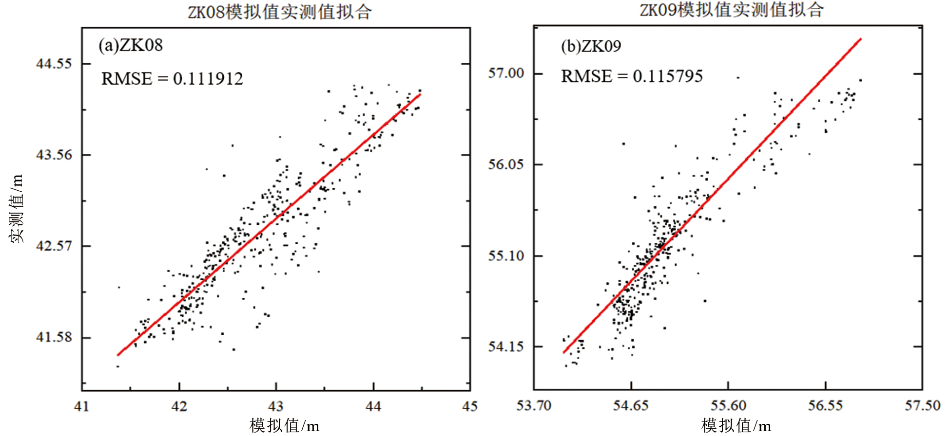
图9 模拟值与实测地下水位值1∶1对比图
Fig.9 1∶1 comparison between simulated and observed groundwater levels a—ZK08; b—ZK09。

图10 初始时刻水头分布图
Fig.10 Spatial distribution of hydraulic head at the initial time

图11 初始时刻裂隙流速流向
Fig.11 Flow velocity and direction within fractures at the initial time

图12 平行长江截面位置及地下水流场
Fig.12 Location of the cross-section parallel to the Yangtze River and the groundwater flow field
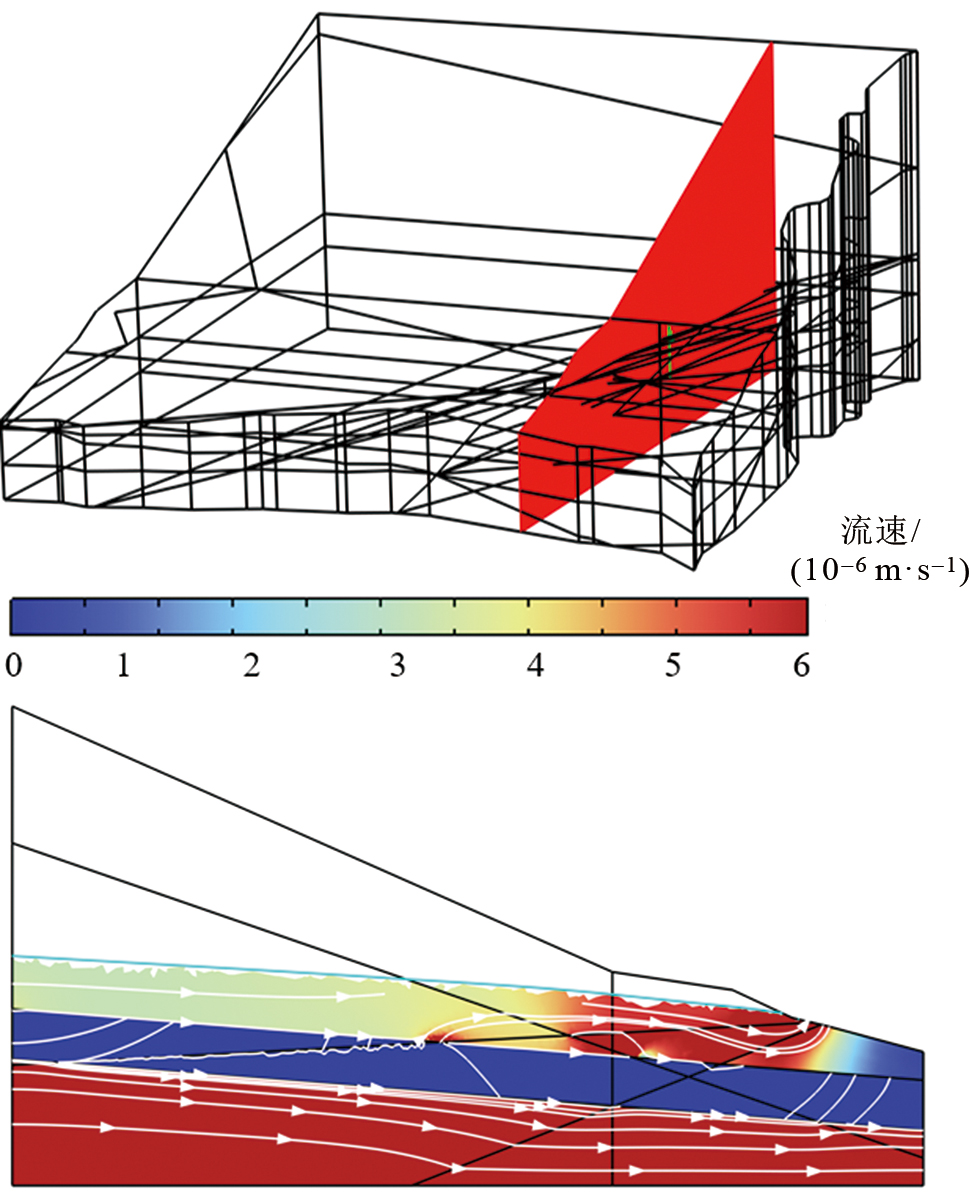
图13 垂直长江截面位置及地下水流场
Fig.13 Location of the cross-section perpendicular to the Yangtze River and the groundwater flow field

图14 地表水-地下水交互通量 a—裂隙含水层;b—大裂隙。
Fig.14 Surface water-groundwater exchange fluxes

图15 地层界面处裂隙水通量 a—浅-中层;b—中-深层。
Fig.15 Fracture water fluxes at stratigraphic interfaces
| [1] |
KRAUSE S, HANNAH D M, FLECKENSTEIN J H, et al. Interdisciplinary perspectives on processes in the hyporheic zone[J]. Ecohydrology, 2011, 4(4): 481-499.
DOI URL |
| [2] |
SOPHOCLEOUS M. Interactions between groundwater and surface water: the state of the science[J]. Hydrogeology Journal, 2002, 10(1): 52-67.
DOI URL |
| [3] | 胡春宏, 郑春苗, 王光谦, 等. “西南河流源区径流变化和适应性利用”重大研究计划进展综述[J]. 中国科学: 地球科学, 2022, 33(3): 337-359. |
| [4] | 金光球, 李凌. 河流中潜流交换研究进展[J]. 水科学进展, 2008, 19(2): 285-293. |
| [5] | 杨蕴, 郭勇, 王发飞, 等. 山谷型小流域地表水与地下水时空交互模拟研究[J]. 水文地质工程地质, 2025, 52(1): 32-41. |
| [6] | 李佳选, 王元元, 宋进喜, 等. 北洛河潜流带水交换研究[J]. 水土保持学报, 2015, 29(2): 310-313. |
| [7] |
GLEESON T, CUTHBERT M, FERGUSON G, et al. Global groundwater sustainability, resources, and systems in the Anthropocene[J]. Annual Review of Earth and Planetary Sciences, 2020, 48(1): 431-463.
DOI URL |
| [8] | 杜尧, 马腾, 邓娅敏, 等. 潜流带水文-生物地球化学: 原理、方法及其生态意义[J]. 地球科学, 2017, 42(5): 661-673. |
| [9] | JIANG Q, JIN G, TANG H, et al. N2O production and consumption processes in a salinity-impacted hyporheic zone[J]. Journal of Geophysical Research: Biogeosciences, 2021, 126(10): e2021JG006512. |
| [10] |
BOANO F, REVELLI R, RIDOLFI L. Modeling hyporheic exchange with unsteady stream discharge and bedform dynamics[J]. Water Resources Research, 2013, 49(7): 4089-4099.
DOI URL |
| [11] |
GOMEZ-VELEZ J D, WILSON J L, CARDENAS M B, et al. Flow and residence times of dynamic river bank storage and sinuosity-driven hyporheic exchange[J]. Water Resources Research, 2017, 53(10): 8572-8595.
DOI URL |
| [12] | 刘东升, 赵坚, 吕辉. 大坝下游河岸带冬夏季水热交换特征对比[J]. 水科学进展, 2017, 28(1): 124-132. |
| [13] | 王大博, 任杰, 代娟, 等. 水位波动对洞庭湖洲滩潜流带水热传输影响[J]. 长江流域资源与环境, 2022, 31(3): 685-697. |
| [14] | 夏继红, 林俊强, 陈永明, 等. 国外河流潜流层研究的发展过程及研究方法[J]. 水利水电科技进展, 2013, 33(4): 73-77. |
| [15] |
BRUNNER P, THERRIEN R, RENARD P, et al. Advances in understanding river-groundwater interactions[J]. Reviews of Geophysics, 2017, 55(3): 818-854.
DOI URL |
| [16] |
FLIPO N, MOUHRI A, LABARTHE B, et al. Continental hydrosystem modelling: the concept of nested stream-aquifer interfaces[J]. Hydrology and Earth System Sciences, 2014, 18(8): 3121-3149.
DOI URL |
| [17] |
KALBUS E, REINSTORF F, SCHIRMER M. Measuring methods for groundwater-surface water interactions: a review[J]. Hydrology and Earth System Sciences, 2006, 10(6): 873-887.
DOI URL |
| [18] |
IRVINE D J, SINGHA K, KURYLYK B L, et al. Groundwater-surface water interactions research: past trends and future directions[J]. Journal of Hydrology, 2024, 644: 132061.
DOI URL |
| [19] |
BOANO F, HARVEY J W, MARION A, et al. Hyporheic flow and transport processes: mechanisms, models, and biogeochemical implications[J]. Reviews of Geophysics, 2014, 52(4): 603-679.
DOI URL |
| [20] |
HESTER E T, CARDENAS M B, HAGGERTY R, et al. The importance and challenge of hyporheic mixing[J]. Water Resources Research, 2017, 53(5): 3565-3575.
DOI URL |
| [21] | 束龙仓, 宫荣, 栾佳文, 等. 地下水与地表水水量交换识别及交换量计算: 以新汴河宿州段为例[J]. 水科学进展, 2022, 33(1): 57-67. |
| [22] |
GOMEZ-VELEZ J D, HARVEY J W, CARDENAS M B, et al. Denitrification in the Mississippi River network controlled by flow through river bedforms[J]. Nature Geoscience, 2015, 8(12): 941-945.
DOI |
| [23] |
GOMEZ-VELEZ J D, HARVEY J W. A hydrogeomorphic river network model predicts where and why hyporheic exchange is important in large basins[J]. Geophysical Research Letters, 2014, 41(18): 6403-6412.
DOI URL |
| [24] | BOANO F, CAMPOREALE C, REVELLI R, et al. Sinuosity-driven hyporheic exchange in meandering rivers[J]. Geophysical Research Letters, 2006, 33(18): L18406. |
| [25] | BOANO F, DEMARIA A, REVELLI R, et al. Biogeochemical zonation due to intrameander hyporheic flow[J]. Water Resources Research, 2010, 46(2): W02511. |
| [26] |
BERKOWITZ B. Characterizing flow and transport in fractured geological media: a review[J]. Advances in Water Resources, 2002, 25(8/9/10/11/12): 861-884.
DOI URL |
| [27] | 赵敬波, 刘健, 周志超, 等. 基于离散裂隙网络模型的地下水流并行模拟方法[J]. 地质科技通报, 2023, 42(4): 55-64. |
| [28] | 毛铖鑫, 贾剑青, 刘中帅. 多裂隙优势渗流对边坡稳定性影响研究[J]. 兰州交通大学学报, 2024, 43(2): 15-21. |
| [29] | 朱余佳. 裂隙性质对含裂隙基坑土坡渗流特性影响数值模拟研究[J]. 重庆工商大学学报(自然科学版), 2021, 38(1): 105-112. |
| [30] |
WERNER A D, ROBINSON N I. Revisiting analytical solutions for steady interface flow in subsea aquifers: aquitard salinity effects[J]. Advances in Water Resources, 2018, 116: 117-126.
DOI URL |
| [31] |
ZHANG Q, WERNER A D. Integrated surface-subsurface modeling of Fuxianhu Lake catchment, Southwest China[J]. Water Resources Management, 2009, 23(11): 2189-2204.
DOI URL |
| [32] | 王肖珊. 岩体裂隙网络的渗流计算及分形特性研究[D]. 济南: 山东大学, 2014. |
| [33] |
SINGH T, WU L, GOMEZ-VELEZ J D, et al. Dynamic hyporheic zones: exploring the role of peak flow events on bedform-induced hyporheic exchange[J]. Water Resources Research, 2019, 55(1): 218-235.
DOI URL |
| [34] |
HE X, SINAN M, KWAK H, et al. A corrected cubic law for single-phase laminar flow through rough-walled fractures[J]. Advances in Water Resources, 2021, 154: 103984.
DOI URL |
| [1] | 董艳辉, 王礼恒, 张倩, 周志超, 文冬光, 李守定, 万力. 深部水文地质学裂隙渗流研究挑战与进展[J]. 地学前缘, 2026, 33(1): 296-312. |
| [2] | 许林, 马海春, 王京平, 张庆, 黄逸航, 钱家忠, 王万林. 高地应力高温条件裂隙介质地下水非线性渗流研究进展[J]. 地学前缘, 2026, 33(1): 313-327. |
| [3] | 周斐然, 尹子悦, 孙晓敏, 宋健, 杨蕴, 吴剑锋. 融合数值模拟和机器学习的民勤盆地地下水潜力评价与主控因素识别[J]. 地学前缘, 2026, 33(1): 511-522. |
| [4] | 何晓, 牛花朋, 赵贤, 周浩彦, 林伟峻, 张关龙, 孟涛, 穆星. 基于数值模拟表征岩石组构对裂缝性储层发育影响程度的机理研究:以济阳坳陷花岗质岩石为例[J]. 地学前缘, 2025, 32(5): 361-376. |
| [5] | 胡景宏, 廖松泽, 蔡益栋, 芦俊. 深部页岩储层压裂裂缝扩展均匀性研究[J]. 地学前缘, 2025, 32(4): 471-482. |
| [6] | 肖昀廷, 蔡晨康, 黄亦心, 朱佳雷. 海表温度日变化特征对海陆风模拟的影响研究[J]. 地学前缘, 2025, 32(3): 218-230. |
| [7] | 余路, 李贤, 崔国栋, 邢东辉, 陆红锋, 王烨嘉. 启动压力对南海北部水合物藏开发动态的影响[J]. 地学前缘, 2025, 32(2): 178-194. |
| [8] | 杨冰, 孟童, 郭华明, 连国玺, 陈帅瑶, 杨曦. 基于Kd的某酸法地浸铀矿山地下水铀运移模拟[J]. 地学前缘, 2024, 31(3): 381-391. |
| [9] | 侯玉松, 胡晓农, 吴吉春. 不同胶结度的多孔介质中溶质横向弥散的孔隙尺度模拟研究[J]. 地学前缘, 2024, 31(3): 59-67. |
| [10] | 谌宏伟, 杨瑶, 黄荷, 周慧, 彭向训, 于莎莎, 喻娓厚, 李正最, 王赵国. 基于氡同位素示踪的洞庭湖区枯水期湖水与地下水交互作用研究[J]. 地学前缘, 2024, 31(2): 423-434. |
| [11] | 李玉丹, 游瑜春, 曾大乾, 石志良, 顾少华, 张睿. 底水气藏水侵规律数值模拟研究:以元坝长兴组气藏为例[J]. 地学前缘, 2023, 30(6): 341-350. |
| [12] | 张允, 康志江, 马郡伟, 郑欢, 吴大卫. 深层离散裂缝油藏多尺度流固耦合数值模拟方法[J]. 地学前缘, 2023, 30(6): 365-370. |
| [13] | 孙哲, 张彬, 陈大伟, 李玉涛, 王汉勋. 花岗岩裂隙岩体油水两相渗流可视化试验及数值模拟研究[J]. 地学前缘, 2023, 30(3): 465-475. |
| [14] | 孙辉, 刘晓东. 青藏高原隆升气候效应的数值模拟研究进展概述[J]. 地学前缘, 2022, 29(5): 300-309. |
| [15] | 沈晓芳, 万玉玉, 王利刚, 苏小四, 董维红. 基于多相流数值模拟的某石油污染场地地下水中VOCs自然衰减过程识别及能力评估[J]. 地学前缘, 2021, 28(5): 90-103. |
| 阅读次数 | ||||||
|
全文 |
|
|||||
|
摘要 |
|
|||||