地学前缘 ›› 2021, Vol. 28 ›› Issue (1): 12-21.DOI: 10.13745/j.esf.sf.2020.5.2
阮壮1( ), 罗忠2, 于炳松1, 卢远征2, 谢灏辰1, 杨志辉1
收稿日期:2019-12-05
修回日期:2020-05-19
出版日期:2021-01-25
发布日期:2021-01-28
作者简介:阮壮(1983—),男,副教授,主要从事沉积地质及油气储层方面的教学、研究工作。E-mail: ruanz0103@cugb.edu.cn
基金资助:
RUAN Zhuang1(), LUO Zhong2, YU Bingsong1, LU Yuanzheng2, XIE Haochen1, YANG Zhihui1
Received:2019-12-05
Revised:2020-05-19
Online:2021-01-25
Published:2021-01-28
摘要:
中—晚三叠世的鄂尔多斯盆地沉积了一套优质的砂岩储层,目前对该套砂岩的成因及其空间分布已经有了成熟的认识,然而在中—晚三叠世鄂尔多斯原型盆地的确切边界位置、盆内古地理演化的构造成因机制等问题上依然存在不少争议。本文通过对鄂尔多斯盆内及周缘57个露头及165口钻井的层序地层学与沉积学研究,厘定了鄂尔多斯盆地在中—晚三叠世的边界位置并在层序格架下开展了古地理演化研究,同时探讨了古地理演化的构造成因。研究表明:中—晚三叠世鄂尔多斯盆地的北部边界从内蒙古的达拉特旗向东延伸至山西大同,东部边界应在山西宁武—太原—太谷—永和—河南安阳—开封—登封一线附近,南部边界为北秦岭(NQT)与华北板块的缝合带(陕西西安—洛南—河南栾川—南召沿线以南),西南以六盘山的西部断层边缘为界,西北界位于贺兰山西部断层边缘带,西部边界延伸至河西走廊盆地的西部边界(甘肃马良沟附近)。在中—上三叠统延长组识别出4个沉积旋回(SQ1-SQ4),代表了从起始阶段(SQ1)到最大沉降阶段(SQ2和SQ3)再到后期关闭阶段(SQ4)的湖泊演化过程。中—晚三叠世鄂尔多斯盆地内呈现出北部/东北部的曲流河-三角洲沉积体系和南部/西南部冲积扇-辫状河-三角洲沉积体系汇聚的沉积格局,在空间上表现出明显的南北差异,在时间上呈现出沉积中心的东-西破坏分异的演化特征。这种古地貌差异和演化主要受控于秦岭—大别山造山带(QDOB)与兴安岭—蒙古造山带(XMOB)的不同构造演化过程。盆地南部的古地理演化主要受控于QDOB的活动,中—晚三叠世勉略洋闭合驱动的北秦岭造山带活化不仅导致盆地南部陡坡带的形成和盆地东南部古地貌的突变,也导致晚三叠世盆地西南部发育一个分隔内克拉通盆地及西南缘类前陆盆地的水下低隆。盆地西部的古地貌演化受控于多种构造机制,中三叠世现今六盘山地区发育一个南北向的低隆区,很可能是盆地东南部的强烈挤压下的远端效应;晚三叠世中期后该低隆区发生下沉,现今鄂尔多斯盆地与河西走廊地区连通,这很可能是由盆地西南方特提斯构造域挤压作用下的盆内挠曲沉降导致的。这些认识不仅是对盆山耦合理论的补充,也对鄂尔多斯盆地石油和天然气的后期勘探具有重要的现实意义。
中图分类号:
阮壮, 罗忠, 于炳松, 卢远征, 谢灏辰, 杨志辉. 鄂尔多斯盆地中—晚三叠世盆地原型及构造古地理响应[J]. 地学前缘, 2021, 28(1): 12-21.
RUAN Zhuang, LUO Zhong, YU Bingsong, LU Yuanzheng, XIE Haochen, YANG Zhihui. Middle-Late Triassic basin prototype and tectonic paleographic response in the Ordos Basin[J]. Earth Science Frontiers, 2021, 28(1): 12-21.
| |
Table 1 Stratigraphic correlation between the modern Ordos Basin the surrounding basins
| |

图1 中—晚三叠世鄂尔多斯原型盆地边界(红色矩形框为图13范围)
Fig.1 Boundary of the Middle-Late Triassic prototype basin in the Ordos Basin (area enclosed in the red rectangle is the same area shown in Fig.13)

图2 鄂尔多斯盆地北部及东部边界露头剖面沉积序列及沉积相解释
Fig.2 Lithostratigraphic columns of Middle-Upper Triassic strata in the Gaotouyao, Ningwu and Chengliu sections, Ordos Basin

图3 鄂尔多斯盆地周缘露头岩石学特征 a—陕西窟野河剖面:长8段厚层橙色粗粒砂岩整合于长7段灰-绿色细粒砂岩与泥岩夹层之上,曲流河河道-泛滥平原沉积。b—河南济源盆地承留剖面:中—厚层砂岩与油页岩夹于杏黄色泥岩之间,黄线为岩性分界面,曲流河三角洲沉积。c—甘肃崆峒山剖面:延长组下部,厚层紫色灰质砾岩,冲积扇沉积。d—甘肃策底坡剖面:延长组中部,厚层灰绿色砾岩覆于中—厚层黄色砂岩之上的岩性分界面,冲积扇沉积。e—甘肃冬青沟剖面:南营儿组中部,厚层砂岩与粉砂质泥岩的旋回地层,实线为冲刷面,虚线为岩性分界面,曲流河三角洲沉积。f—宁夏汝萁沟剖面:延长组下部,黄绿色砾岩与黄绿色砂岩夹层,实线为砾岩和砂岩的岩性分界面,冲积扇沉积。
Fig.3 Lithological characteristics of outcrops around the Ordos Basin
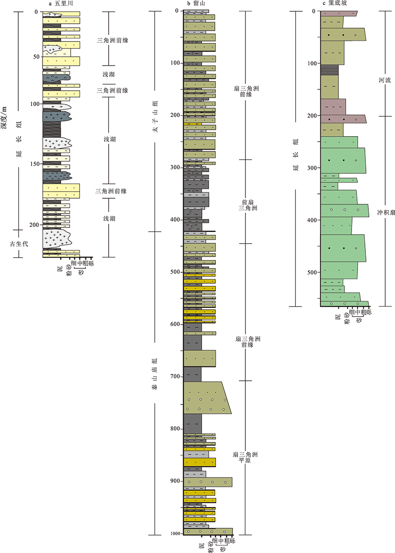
图4 鄂尔多斯盆地南部边界露头剖面沉积序列及沉积相解释(图例见图2)
Fig.4 Lithostratigraphic columns of Middle-Upper Triassic strata in the Wulichuan, Liushan and Cedipo sections, Ordos Basin (See Fig.2 for figure legend)
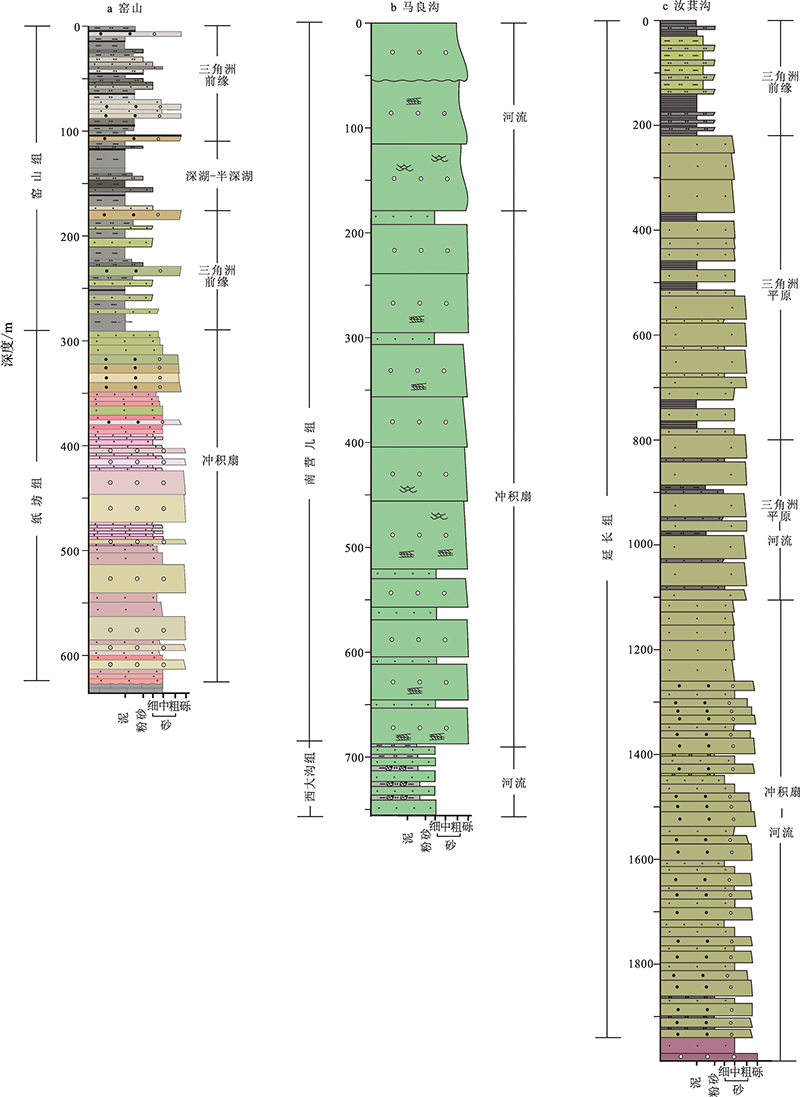
图5 鄂尔多斯盆地西部边界露头剖面沉积序列及沉积相解释(图例见图2)
Fig.5 Lithostratigraphic columns of Middle-Upper Triassic strata in the Yaoshan, Malianggou and Ruishuihe sections, Ordos Basin (See Fig.2 for figure legend)

图6 鄂尔多斯盆地汭水河地区延长组层序及沉积相综合柱状图 MFS—最大洪泛面;SU—地表沉积间断;LAST—低可容空间体系域;HAST—高可容空间体系域。
Fig.6 Columnar section showing, from left to right, the sedimentary features of the floodplain, braided (meandering) river-deltaic and lacustrine facies as well as the sequence stratigraphic delineation of the Yanchang Formation in the Ruishuihe section, Ordos Basin
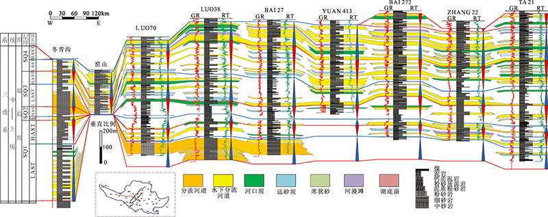
图7 鄂尔多斯盆地延长组东西向层序及沉积相对比剖面
Fig.7 Correlation of sequences and depositional facies of the Yanchang Formation from west to east across boreholes and outcrops in the Ordos Basin
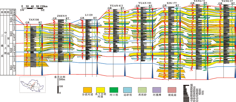
图8 鄂尔多斯盆地延长组东北-西南向层序及沉积相对比剖面
Fig.8 Correlation of sequences and depositional facies of the Yanchang Formation from NE to SW across boreholes in the Ordos Basin
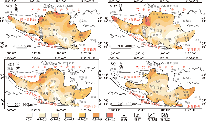
图9 鄂尔多斯原型盆地延长组SQ1—SQ4沉积旋回砂地比等值线图
Fig.9 Contour map of the sandstone/stratum thickness ratio for the depositional sequences (SQ1-SQ4) of the Yanchang Formation, Ordos Basin
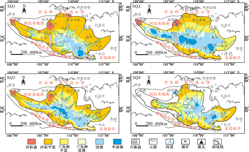
图10 鄂尔多斯原型盆地延长组沉积序列的古地理图
Fig.10 Paleogeographic map of the depositional sequences of the Yanchang Formation, Ordos Basin
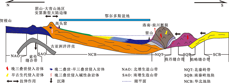
图11 中—晚三叠世鄂尔多斯盆地构造背景模型
Fig.11 A tectonic model of the Ordos Basin during the Middle-Late Triassic
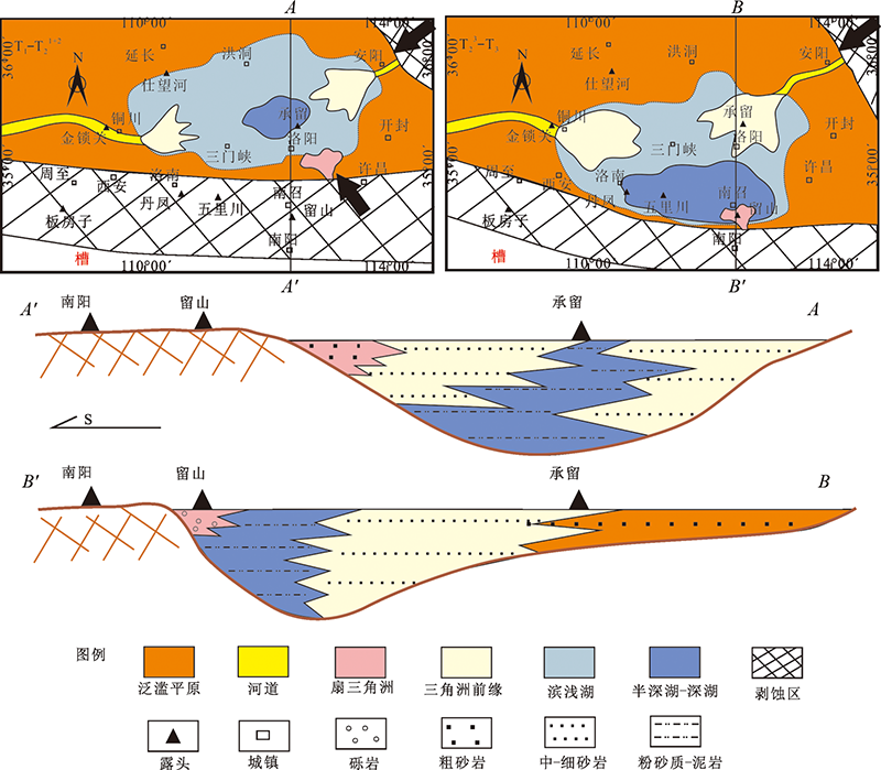
图12 鄂尔多斯盆地东南部早—中三叠世与中—晚三叠世的沉积地貌演化
Fig.12 Sedimentary evolutions of the southeastern Ordos Basin in the Early-Middle Triassic and Middle-Late Triassic periods

图13 鄂尔多斯盆地延长组SQ3旋回地层厚度及西南缘沉积模式(A-A')
Fig.13 Stratigraphic thickness of the SQ3 unit in the Yanchang Formation and depositional pattern in the southwestern section (A-A') in the Ordos Basin
| [1] | 董云鹏, 张国伟. 造山带与前陆盆地结构构造及动力学研究思路和进展[J]. 地球科学进展, 1997, 12(1):1-6. |
| [2] |
LIU T, DING Z. Chinese loess and the paleo monsoon[J]. Annual Review Earth and Planetary Sciences, 1998, 26:111-145.
DOI URL |
| [3] | 刘和甫. 盆地-山岭耦合体系与地球动力学机制[J]. 地球科学: 中国地质大学学报, 2001, 26(6):581-596. |
| [4] | 刘树根, 罗志立, 赵锡奎, 等. 中国西部盆山系统的耦合关系及其动力学模式: 以龙门山造山带-川西前陆盆地系统为例[J]. 地质学报, 2003, 77(2):177-186. |
| [5] | 王清晨, 李忠. 盆山耦合与沉积盆地成因[J]. 沉积学报, 2003, 21(1):24-30. |
| [6] | 刘少峰, 李思田, 张国伟. 论造山带与盆地演化的耦合与非耦合关系: 秦岭及其旁侧盆地为例[M]//马宗晋. 构造地质学-岩石圈动力学研究进展. 北京: 地震出版社, 1999: 356-363. |
| [7] | 吴根耀. 造山带古地理学: 在盆地构造古地理重建中的若干思考[J]. 古地理学报, 2005, 7(3):405-416. |
| [8] |
KANYGIN A, DRONOV A, TIMOKHIN A, et al. Depositional sequences and palaeoceanographic change in the Ordovician of the Siberian craton[J]. Palaeogeography, Palaeoclimatology, Palaeoecology, 2010, 296(3/4):285-296.
DOI URL |
| [9] |
JOHNSON E A, LIU S, ZHANG Y L. Depositional environments and tectonic controls on the coal-bearing Lower to Middle Jurassic Yan’an Formation, southern Ordos Basin, China[J]. Geology, 1989, 17:1123-1126.
DOI URL |
| [10] | 陈法正. 砂岩型铀矿的成矿地质条件与战略选区: 以二连盆地和鄂尔多斯盆地为例[J]. 铀矿地质, 2002, 18(3):138-143. |
| [11] |
HAN S, HORSFIELD B, ZHANG J, et al. Hydrocarbon generation kinetics of Lacustrine Yanchang Shale in Southeast Ordos Basin, North China[J]. Energy & Fuels, 2014, 28(9):5632-5639.
DOI URL |
| [12] | 何自新. 鄂尔多斯盆地演化与油气[M]. 北京: 石油工业出版社, 2003. |
| [13] |
ZHAO J, ZHANG W, LI J, et al. Genesis of tight sand gas in the Ordos Basin, China[J]. Organic Geochemistry, 2014, 74:76-84.
DOI URL |
| [14] | 刘池洋, 赵红格, 王锋, 等. 鄂尔多斯盆地西缘(部)中生代构造属性[J]. 地质学报, 2005(6):737-747. |
| [15] |
YANG R C, HE Z L, QIU G Q, et al. A Late Triassic gravity flow depositional system in the southern Ordos Basin[J]. Petroleum Exploration and Development, 2014, 41(6):724-733.
DOI URL |
| [16] |
BAO C, CHEN Y, LI D, et al. Provenances of the Mesozoic sediments in the Ordos Basin and implications for collision between the North China Craton (NCC) and the South China Craton (SCC)[J]. Journal of Asian Earth Sciences, 2014, 96:296-307.
DOI URL |
| [17] | 廖昌珍, 张岳桥, 温长顺. 鄂尔多斯盆地东缘边界带构造样式及其区域构造意义[J]. 地质学报, 2007, 87:466-474. |
| [18] |
ZOU C N, ZHANG X Y, LUO P, et al. Shallow-lacustrine sand-rich deltaic depositional cycles and sequence stratigraphy of the Upper Triassic Yanchang Formation, Ordos Basin, China[J]. Basin Research, 2010, 22(1):108-125.
DOI URL |
| [19] | LIU Z, SHEN F, ZHU X, et al. Formation conditions and sedimentary characteristics of a Triassic shallow water braided delta in the Yanchang Formation, Southwest Ordos Basin, China[J]. Plos One, 2015, 10(6):1-19. |
| [20] |
ZHAO J, MOUNTNEY N P, LIU C, et al. Outcrop architecture of a fluvio-lacustrine succession: upper Triassic Yanchang Formation, Ordos Basin, China[J]. Marine and Petroleum Geology, 2015, 68:394-413.
DOI URL |
| [21] |
XIE X. Provenance and sediment dispersal of the Triassic Yanchang Formation, southwest Ordos Basin, China, and its implications[J]. Sedimentary Geology, 2016, 335:1-16.
DOI URL |
| [22] | 刘绍龙. 华北地区大型三叠纪原始沉积盆地的存在[J]. 地质学报, 1986, 60(2):128-138. |
| [23] | ZHAO Z Y, LIU C Y. Basins in the residual Craton and their petroleum prospect-example with Ordos Basin and Sichuan Basin[M]//ACADEMY C G. Dissertation anthology at the academic communion conference in “Seven-Five” geology technological important fruits. Beijing: Science and Technology Publishing Company, 1992: 610-613. |
| [24] | 杨华, 陈洪德, 付金华. 鄂尔多斯盆地晚三叠世沉积地质与油藏分布规律[M]. 北京: 科学出版社, 2012. |
| [25] | YIN A, NIE S Y. A Phanerozoic palinspastic reconstruction of China and its neighboring regions[M]//YIN A, HARRISON M. Tectonic evolution of Asia. Cambridge: Cambridge University Press, 1996: 442-484. |
| [26] | 任纪舜, 王作勋, 陈炳蔚. 中国及邻区大地构造图[M]. 北京: 地质出版社, 1997. |
| [27] |
WEISLOGEL A L, GRANHAM S A, CHANG E Z, et al. Detrital-zircon provenance of the Late Triassic Songpan-Ganzi complex: sedimentary record of collision of the North and South China blocks[J]. Geology, 2006, 34:97-100.
DOI URL |
| [28] | 李相博, 刘化清, 完颜容, 等. 鄂尔多斯晚三叠世盆地构造属性及后期改造[J]. 石油实验地质, 2012, 34(4):374-396. |
| [29] | LIU C, ZHAO H, SUN Y. Tectonic background of Ordos Basin and its controlling role for basin evolution and energy mineral deposits[J]. Energy Exploration & Exploitation, 2009, 27(1):15-27. |
| [30] |
WANG Q Y, LIU X. Paleoplate tectonics between Cathaysia and Angaraland in Inner Mongolia of China[J]. Tectonics, 1986, 5:1073-1088.
DOI URL |
| [31] | XIAO W, WINDLEY B F, HAO J, et al. Accretion leading to collision and the Permian Solonker suture, Inner Mongolia, China: termination of the central Asian orogenic belt[J]. Tectonics, 2003, 22(6):1-20. |
| [32] |
LI J Y. Permian geodynamic setting of Northeast China and adjacent regions: closure of the Paleo-Asian Ocean and subduction of the Paleo-Pacific Plate[J]. Journal of Asian Earth Sciences, 2006, 26:207-224.
DOI URL |
| [33] |
ZHANG S H, ZHAO Y, SONG B, et al. Carboniferous granitic plutons from the northern margin of the North China Block: implications for a Late Paleozoic active continental margin[J]. Journal of the Geological Society of London, 2007, 164:451-463.
DOI URL |
| [34] | ZHANG S H, ZHAO Y, SONG B, et al. Contrasting Late Carboniferous and Late Permian-Middle Triassic intrusive suites from the northern margin of the North China Craton: geochronology, petrogenesis and tectonic implications[J]. Geological Society of America Bulletin, 2009, 121(121):181-200. |
| [35] | 邵济安, 张履桥. 华北北部中生代岩墙群[J]. 岩石学报, 2002, 18(3):312-318. |
| [36] | 邵济安, 张永北, 张履桥, 等. 大同地区早中生代煌斑岩-碳酸岩岩墙群[J]. 岩石学报, 2003, 19(1):93-104. |
| [37] |
MU B L, YAN G H. Geological features of Triassic Alkaline and subalkaline igneous complexes in the Yan-Liao area[J]. Acta Geologica Sinica (English Edition), 1992, 5(4):339-355.
DOI URL |
| [38] |
LI Z, QU H, GONG W. Late Mesozoic basin development and tectonic setting of the northern North China Craton[J]. Journal of Asian Earth Sciences, 2015, 114:115-139.
DOI URL |
| [39] | 李润兰, 朱峰, 许清海. 大同—阳原盆地的形成与演变[J]. 古地理学报, 2000, 2(2):92-96. |
| [40] | 漆家福, 于福生, 陆克政, 等. 渤海湾地区的中生代盆地构造概述[J]. 地学前缘, 2003, 10(特刊):199-206. |
| [41] | ZHAO J F, LIU C Y, WANG X M, et al. Migration of depocenters and accumulation centers and its indication of subsidence centers in the Mesozoic Ordos Basin[J]. Acta Geologica Sinica (English Edition), 2009(2):278-294. |
| [42] | 彭兆蒙, 吴智平. 华北地区三叠纪地层发育特征及原始沉积格局分析[J]. 高校地质学报, 2006, 12(3):343-352. |
| [43] | 王明健, 何登发, 李文涛, 等. 渤海湾盆地临清坳陷东部边界断裂: 兰聊断层几何学、形成演化与成因机制[J]. 地质科学, 2011, 46(3):775-786. |
| [44] |
KRÖNER A, ZHANG G W, ZHUO D W, et al. Granulites in the Tongbai area, Qinling belt, China: geochemistry, petrology, single zircon geochronology and implications for tectonic evolution of eastern Asia[J]. Tectonics, 1993, 12:245-255.
DOI URL |
| [45] |
AMES L, ZHOU G Z, XIONG B C. Geochronology and isotopic character of ultrahigh-pressure metamorphism with implications for collision of the Sino-Korean and Yangtze cratons, central China[J]. Tectonics, 1996, 15:472-489.
DOI URL |
| [46] | ZHANG H F, ZHANG B R, LING W L, et al. Paleo-oceanic crust recycling in north Qinling: evidence of Pb, Nd, Sr isotopes from island arc granitoids[J]. Chinese Science Bulletin, 1996, 41:234-237. |
| [47] |
DONG Y, ZHANG G, NEUBAUER F, et al. Tectonic evolution of the Qinling orogen, China: review and synjournal[J]. Journal of Asian Earth Sciences, 2011, 41(3):213-237.
DOI URL |
| [48] | 刘化清, 李相博, 陈启林. 鄂尔多斯盆地延长组若干石油地质问题分析[M]. 北京: 科学出版社, 2013. |
| [49] | 赵文智, 王新民, 郭彦如, 等. 鄂尔多斯盆地西部晚三叠世原型盆地恢复及其改造演化[J]. 石油勘探与开发, 2006, 33(1):6-13. |
| [50] |
XIE X, HELLER P L. U-Pb detrital zircon geochronology and its implications: the early Late Triassic Yanchang Formation, south Ordos Basin, China[J]. Journal of Asian Earth Sciences, 2013, 64:86-98.
DOI URL |
| [51] | 彭希龄. 有关陕北盆地西部边缘的一些构造问题[J]. 地质学报, 1955, 29(4):405-417. |
| [52] | LIU S F, LI S T, ZHUANG X G, et al. Modeling of subsidence and sedimentary courses in the foreland basin of southwest margin of Ordos Basin[J]. Acta Geologica Sinica, 1996, 70(1):12-22. |
| [53] | 杨俊杰. 鄂尔多斯盆地构造演化与油气分布规律[M]. 北京: 石油工业出版社, 2002. |
| [54] | 汤锡元, 郭忠铭, 陈荷立. 陕甘宁盆地西缘逆冲推覆构造带油气勘探[M]. 西安: 西北大学出版社, 1988. |
| [55] | 翟光明, 宋建国, 靳久强. 板块构造演化与含油气盆地的形成和评价[M]. 北京: 石油工业出版社, 2002. |
| [56] | VAIL P R, MITCHUM R M, THOMPSON S. Seismic stratigraphy and global changes of sea level, Part 3: relative changes of sea level from coastal onlap[J]. AAPG Memoir, 1977, 26:63-81. |
| [57] | MILLIGAN M, CHAN M, SHANLEY K W, et al. Coarse-grained gilbert deltas; facies, sequence stratigraphy and relationships to Pleistocene climate at the eastern margin of the Lake Bonneville, northern Utah[J]. Special Publication: Society for Sedimentary Geology, 1998, 59:177-189. |
| [58] | CATUNEANU O. Principles of sequence stratigraphy[M]. Amsterdam: Elsevier, 2006: 386. |
| [59] |
CATUNEANU O, ABREUB V, BHATTACHARYA J, et al. Towards the standardization of sequence stratigraphy[J]. Earth-Science Reviews, 2009, 92(1/2):1-33.
DOI URL |
| [60] |
SHANLEY K W, MCCABE P J. Predicting facies architecture through sequence stratigraphy: an example from the Kaiparowits Plateau, Utah[J]. Geology, 1991, 19:742-745.
DOI URL |
| [61] |
OLSEN T, STEEL R, HOGSETH K, et al. Sequential architecture in a fluvial succession: sequence stratigraphy in the Upper Cretaceous Mesaverde Group, Price Canyon, Utah[J]. Journal of Sedimentary Research, 1995, 65(2b):265-280.
DOI URL |
| [62] | VANWAGONER J C. Sequence stratigraphy and marine to nonmarine facies architecture of foreland basin strata, Book Cliffs, Utah, USA[J]. AAPG Memoir, 1995, 64:137-223. |
| [63] | DALRYMPLE M, PROSSER J, WILLIAMS B. A dynamic systems approach to the regional controls on deposition and architecture of alluvial sequences, illustrated in the Stratford Formation (United Kingdom, Northern North Sea)[J]. SEPM Special Publication, 1998, 59:65-82. |
| [64] |
MARTINSEN O, RYSETH A, HANSEN W H, et al. Stratigraphic base level and fluvial architecture: Ericson sandstone (Campanian), rock springs uplift, SW Wyoming, USA[J]. Sedimentology, 1999, 46:235-259.
DOI URL |
| [65] |
ROJAS-AGRAMONTE Y, KRÖNER A, DEMOUX A, et al. Detrital and xenocrystic zircon ages from Neoproterozoic to Palaeozoic arc terranes of Mongolia: significance for the origin of crustal fragments in the Central Asian Orogenic Belt[J]. Gondwana Research, 2011, 19(3):751-763.
DOI URL |
| [66] |
WILHEM C, WINDLEY B F, STAMPFLI G M. The Altaids of Central Asia: a tectonic and evolutionary innovative review[J]. Earth-Science Reviews, 2012, 113:303-341.
DOI URL |
| [67] | 韩天佑, 李慧, 李文厚, 等. 鄂尔多斯盆地延河剖面延长组碎屑锆石U-Pb年龄分布特征及地质意义[J]. 西北地质, 2011, 44(1):105-111. |
| [68] |
XIAO W J, WINDLEY B F, HUANG B C, et al. End-Permian to mid-Triassic termination of the accretionary processes of the southern Altaids: implications for the geodynamic evolution, Phanerozoic continental growth, and metallogeny of Central Asia[J]. International Journal of Earth Sciences, 2009, 98(6):1189-1217.
DOI URL |
| [69] |
EIZENHÖFER P R, ZHAO G, ZHANG J, et al. Final closure of the Paleo-Asian Ocean along the Solonker Suture Zone: constraints from geochronological and geochemical data of Permian volcanic and sedimentary rocks[J]. Tectonics, 2014, 33(4):441-463.
DOI URL |
| [70] | 张拴宏, 赵越, 刘建民, 等. 华北地块北缘晚古生代—早中生代岩浆活动期次、特征及构造背景[J]. 岩石矿物学杂志, 2010, 29(6):824-842. |
| [71] |
ZHAO X X, COE R S. Palaeomagnetic constraints on the collision and rotation of North and South China[J]. Nature, 1987, 327(14):141-144.
DOI URL |
| [72] | 刘帅, 阮壮, 杨志辉, 等. 鄂尔多斯盆地南缘中晚三叠世物源演变及其地质意义[J]. 古地理学报, 2019, 21(6):939-958. |
| [73] |
YIN A, NIE S. An indentation model for the north and south China collision and the development of the Tan-Lu and Honam fault systems, eastern Asia[J]. Tectonics, 1993, 12(4):801-813.
DOI URL |
| [74] | ZHU R X, YANG Z, WU H N. Phanerozoic palaeomagnetic apparent polar wander path and block motion of Chinese primary block[J]. Science in China Series D: Earth Science, 1998, 28(Suppl):1-16. |
| [75] | 何登发, 庄忠海, 马永生. 松潘—阿坝地块三叠系古地磁结果及运动学意义[J]. 现代地质, 2007, 21(3):556-563. |
| [76] | 张天舒, 吴因业, 郭彬程, 等. 鄂尔多斯盆地西南缘晚三叠世前陆冲断活动控制的沉积层序特征[J]. 地学前缘, 2012, 19(1):40-50. |
| [77] | 夏义平, 徐礼贵, 郑良合, 等. 鄂尔多斯盆地西缘逆冲断裂带构造特征及油气勘探方向[J]. 中国石油勘探, 2005, 10(5):13-19. |
| [78] | 孙肇才. 中国中西部中—新生代前陆类盆地及其含油气性[M]. 北京: 石油工业出版社, 2002: 73-95. |
| [79] | 谭聪, 阮壮, 于炳松, 等. 鄂尔多斯盆地西缘中—晚三叠世构造-物源-古地貌体系演化: 来自碎屑锆石、地球化学和岩石学的证据[J]. 石油学报, 2019, 40(6):660-676. |
| [80] | 李斌, 孟自芳, 宋岩, 等. 鄂尔多斯盆地西缘前陆盆地构造-沉积响应[J]. 吉林大学学报(地球科学版), 2007, 37(4):703-709. |
| [1] | 刘艳祥, 吕文雅, 曾联波, 李睿琦, 董少群, 王兆生, 李彦录, 王磊飞, 冀春秋. 鄂尔多斯盆地庆城油田长7页岩油储层多尺度裂缝三维地质建模[J]. 地学前缘, 2024, 31(5): 103-116. |
| [2] | 陈如彪, 王玉满, 黄正良, 李维岭, 闫伟, 梁峰, 郭玮. 鄂尔多斯盆地西北缘海相页岩裂缝孔隙发育特征与页岩气富集模式:以奥陶系乌拉力克组为例[J]. 地学前缘, 2024, 31(5): 46-60. |
| [3] | 邱林飞, 李子颖, 张字龙, 王龙辉, 李振成, 韩美芝, 王婷婷. 鄂尔多斯盆地北部下白垩统赋矿砂岩中有机质特征及其与铀成矿的关系[J]. 地学前缘, 2024, 31(4): 281-296. |
| [4] | 苏恺明, 徐耀辉, 徐旺林, 张月巧, 白斌, 李阳, 严刚. 鄂尔多斯盆地延长组多油源贡献比例与分布规律:基于机器学习与可解释性研究[J]. 地学前缘, 2024, 31(3): 530-540. |
| [5] | 刘持恒, 李子颖, 贺锋, 张字龙, 李振成, 凌明星, 刘瑞萍. 鄂尔多斯盆地西北部下白垩统物源定量分析研究[J]. 地学前缘, 2024, 31(3): 80-99. |
| [6] | 刘池洋, 张龙, 黄雷, 吴柏林, 王建强, 张东东, 谭成仟, 马艳萍, 赵建社. 砂岩型铀矿形成的新模式:来自深部有机流体的成矿作用[J]. 地学前缘, 2024, 31(1): 368-383. |
| [7] | 翟咏荷, 何登发, 开百泽. 鄂尔多斯盆地及邻区早二叠世构造-沉积环境与原型盆地演化[J]. 地学前缘, 2023, 30(2): 139-153. |
| [8] | 牟汉生, 薛欣宇, 姜在兴. 燕山构造带东段中生界盆地页岩油气地质研究现状与展望[J]. 地学前缘, 2023, 30(2): 282-295. |
| [9] | 刘震, 朱茂林, 潘高峰, 夏鲁, 卢朝进, 刘明洁, 刘静静, 侯英杰. 鄂尔多斯盆地中南部地区延长组砂岩溶蚀增孔模型的建立与应用[J]. 地学前缘, 2023, 30(2): 96-108. |
| [10] | 王香增. 鄂尔多斯盆地延长探区低渗致密油气成藏理论进展及勘探实践[J]. 地学前缘, 2023, 30(1): 143-155. |
| [11] | 付金华. 鄂尔多斯盆地太原组致密灰岩天然气成藏地质特征与勘探潜力[J]. 地学前缘, 2023, 30(1): 20-29. |
| [12] | 王小军, 宋永, 郑孟林, 郭旭光, 吴海生, 任海姣, 王韬, 常秋生, 何文军, 王霞田, 郭建辰, 霍进杰. 准噶尔西部陆内盆地构造演化与油气聚集[J]. 地学前缘, 2022, 29(6): 188-205. |
| [13] | 郑和荣, 胡宗全, 云露, 林会喜, 邓尚, 贾会冲, 蒲勇. 中国海相克拉通盆地内部走滑断裂发育特征及控藏作用[J]. 地学前缘, 2022, 29(6): 224-238. |
| [14] | 熊伟东, 肖安成, 魏国齐, 吴磊, 张春林, 王依平, 杨流昀, 王芊芊. 鄂尔多斯盆地南缘寒武纪同沉积伸展断裂系统及其成因机制分析[J]. 地学前缘, 2022, 29(6): 305-313. |
| [15] | 罗金海, 畅莹磊, 陈卓. 鄂尔多斯盆地西南部晚三叠世辉绿岩年代学、地球化学及其构造意义[J]. 地学前缘, 2022, 29(6): 314-324. |
| 阅读次数 | ||||||
|
全文 |
|
|||||
|
摘要 |
|
|||||
