Earth Science Frontiers ›› 2025, Vol. 32 ›› Issue (4): 213-221.DOI: 10.13745/j.esf.sf.2025.4.57
Previous Articles Next Articles
WANG Yao1,2( ), XIAO Keyan1,2,*(), TANG Rui1,2, LI Cheng1, KONG Yunhui1
Received:2024-11-30
Revised:2025-04-21
Online:2025-07-25
Published:2025-08-04
CLC Number:
WANG Yao, XIAO Keyan, TANG Rui, LI Cheng, KONG Yunhui. Integrated multi-source data-driven alteration mineral mapping and its geological applications: A case study in the Xinhure area, Inner Mongolia[J]. Earth Science Frontiers, 2025, 32(4): 213-221.
| 可见短波 红外高光 谱相机 | 光谱范围 | 0.4~2.5 mm |
|---|---|---|
| 空间分辨率 | 30 m | |
| 幅宽 | 60 km | |
| 光谱分辨率 | VNIR: 5 nm; SWIR: 10 nm | |
| 大气环境红 外甚高分辨 率探测仪 | 光谱范围 | 750~4 100 cm |
| 光谱分辨率 | 0.03 cm | |
| 全谱段光谱 成像仪 | 光谱范围 | 0.45~5.05 mm |
| 空间分辨率 | 8.01~12.5 mm 共12个通道 | |
| 幅宽 | 60 km |
Table 1 Main load parameters of GF-5 hyperspectral data
| 可见短波 红外高光 谱相机 | 光谱范围 | 0.4~2.5 mm |
|---|---|---|
| 空间分辨率 | 30 m | |
| 幅宽 | 60 km | |
| 光谱分辨率 | VNIR: 5 nm; SWIR: 10 nm | |
| 大气环境红 外甚高分辨 率探测仪 | 光谱范围 | 750~4 100 cm |
| 光谱分辨率 | 0.03 cm | |
| 全谱段光谱 成像仪 | 光谱范围 | 0.45~5.05 mm |
| 空间分辨率 | 8.01~12.5 mm 共12个通道 | |
| 幅宽 | 60 km |

Fig.1 Regional geological sketch map of the study area. Modified after [41].

Fig.2 Flow chart of GF-5 hyperspectral data preprocessing technology
| 波段序号 | 波长 位置/nm | 剔除 原因 | 谱段 范围 | 剔除 波段数 |
|---|---|---|---|---|
| Band 145~149 | 1 001~1 013 | 低信噪比 | VNIR | 6 |
| Band 150 | 1 014 | 低信噪比 | ||
| Band 193~200 | 1 359~1 434 | 水汽吸收波段, 无数据 | SWIR | 8 |
| Band 246~262 | 1 805~1 956 | 水汽吸收波段, 无数据 | 17 | |
| Band 328~330 | 2 495~2 513 | 低信噪比 | 3 |
Table 2 Eliminated bands of GF-5 hyperspectral data
| 波段序号 | 波长 位置/nm | 剔除 原因 | 谱段 范围 | 剔除 波段数 |
|---|---|---|---|---|
| Band 145~149 | 1 001~1 013 | 低信噪比 | VNIR | 6 |
| Band 150 | 1 014 | 低信噪比 | ||
| Band 193~200 | 1 359~1 434 | 水汽吸收波段, 无数据 | SWIR | 8 |
| Band 246~262 | 1 805~1 956 | 水汽吸收波段, 无数据 | 17 | |
| Band 328~330 | 2 495~2 513 | 低信噪比 | 3 |
| 参数明细 | 参数设置 |
|---|---|
| 影像中心坐标(scene center location) | E109.1°, N41.7° |
| 传感器高度(sensor altitude/km) | 705 km |
| 地面平均海拔(ground elevation/km) | 1.534 km |
| 成像时间(flight data) | 2024-05-12 UTC 5:34:56 |
| 大气模式(atmospheric model) | Sub-Arctic(SAS) |
| 水汽吸收波段(water absorption band) | 1 135 nm |
| 气溶胶模式(aerosol model) | 乡村(rural) |
Table 3 Atmospheric correction parameters of GF-5 hyperspectral data
| 参数明细 | 参数设置 |
|---|---|
| 影像中心坐标(scene center location) | E109.1°, N41.7° |
| 传感器高度(sensor altitude/km) | 705 km |
| 地面平均海拔(ground elevation/km) | 1.534 km |
| 成像时间(flight data) | 2024-05-12 UTC 5:34:56 |
| 大气模式(atmospheric model) | Sub-Arctic(SAS) |
| 水汽吸收波段(water absorption band) | 1 135 nm |
| 气溶胶模式(aerosol model) | 乡村(rural) |
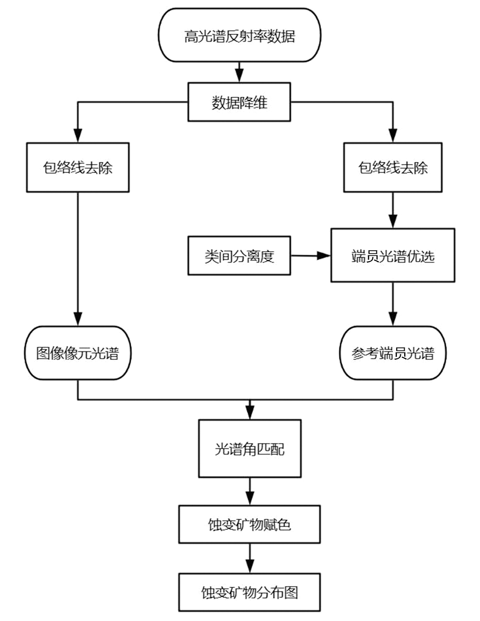
Fig.3 Technical workflow showing mineral mapping based on GF-5 data
| 蚀变矿物 | 各蚀变矿物间分离程度值 | ||||||
|---|---|---|---|---|---|---|---|
| 高岭石 | 白云母 | 蒙脱石 | 明矾石 | 赤铁矿 | 钛铁矿 | 针铁矿 | |
| 高岭石 | 0 | 1.999 999 44 | 2 | 1.999 999 80 | 2 | 2 | 1.999 999 08 |
| 白云母 | 1.999 999 44 | 0 | 1.999 999 93 | 1.999 885 99 | 2 | 1.999 993 16 | 1.999 174 53 |
| 蒙脱石 | 2 | 1.999 999 93 | 0 | 1.999 996 12 | 2 | 1.999 999 57 | 1.999 998 51 |
| 明矾石 | 1.999 999 80 | 1.999 885 99 | 1.999 996 12 | 0 | 2 | 1.999 715 13 | 1.996 772 22 |
| 赤铁矿 | 2 | 2 | 2 | 2 | 0 | 2 | 2 |
| 钛铁矿 | 2 | 1.999 993 16 | 1.999 999 57 | 1.999 715 13 | 2 | 0 | 1.999 965 66 |
| 针铁矿 | 1.999 999 08 | 1.999 174 53 | 1.999 998 51 | 1.996 772 22 | 2 | 1.999 965 66 | 0 |
Table 4 Values of the degree of separation of alteration minerals(JM,TD)
| 蚀变矿物 | 各蚀变矿物间分离程度值 | ||||||
|---|---|---|---|---|---|---|---|
| 高岭石 | 白云母 | 蒙脱石 | 明矾石 | 赤铁矿 | 钛铁矿 | 针铁矿 | |
| 高岭石 | 0 | 1.999 999 44 | 2 | 1.999 999 80 | 2 | 2 | 1.999 999 08 |
| 白云母 | 1.999 999 44 | 0 | 1.999 999 93 | 1.999 885 99 | 2 | 1.999 993 16 | 1.999 174 53 |
| 蒙脱石 | 2 | 1.999 999 93 | 0 | 1.999 996 12 | 2 | 1.999 999 57 | 1.999 998 51 |
| 明矾石 | 1.999 999 80 | 1.999 885 99 | 1.999 996 12 | 0 | 2 | 1.999 715 13 | 1.996 772 22 |
| 赤铁矿 | 2 | 2 | 2 | 2 | 0 | 2 | 2 |
| 钛铁矿 | 2 | 1.999 993 16 | 1.999 999 57 | 1.999 715 13 | 2 | 0 | 1.999 965 66 |
| 针铁矿 | 1.999 999 08 | 1.999 174 53 | 1.999 998 51 | 1.996 772 22 | 2 | 1.999 965 66 | 0 |

Fig.4 Minerals end-member spectra of GF-5 data

Fig.5 Map showing distribution of alteration minerals extracted from hyperspectral data in the study area. 1—Kaolinite; 2—Muscovite; 3—Montmorillonite; 4—Alunite; 5—Hematite; 6—Ilmenite; 7—Goethite; 8—Calcite.

Fig.6 Multi-source comprehensive information map of geological alteration minerals in the study area. 1—Kaolinite; 2—Muscovite; 3—Montmorillonite; 4—Alunite; 5—Hematite; 6—Ilmenite; 7—Goethite; 8—Calcite.
| [1] | 高猛, 付翰泽, 陈川. 遥感技术在和田玉成矿要素识别与找矿预测中的应用:以南阿尔金塔什萨依一带为例[J]. 西北地质, 2019, 52(3):240-252. |
| [2] | 金谋顺, 高永宝, 李侃, 等. 伟晶岩型稀有金属矿的遥感找矿方法—:以西昆仑大红柳滩地区为例[J]. 西北地质, 2019, 52(4): 222-231. |
| [3] | MOHAMED M, AL-NAIMI L, MGBEOJEDO T, et al. Geological mapping and mineral prospectivity using remote sensing and GIS in parts of Hamissana, Northeast Sudan[J]. Journal of Petroleum Exploration and Production, 2021, 11(3): 1123-1138. |
| [4] | 连琛芹, 封志明, 刘永新, 等. 基于中高分辨率数据的内蒙古红石山地区遥感找矿信息提取及找矿预测[J]. 现代地质, 2023, 37(1): 227-232. |
| [5] | 褚志远, 温殿刚, 吕青, 等. 山东蒙阴地区金刚石遥感找矿模型的构建与应用[J]. 地球科学与环境学报, 2024, 46(2): 240-251. |
| [6] | 谭荣, 徐裕敏, 徐先宇, 等. 江西德安彭山矿田遥感找矿预测研究[J]. 岩石矿物学杂志, 2024, 43(4): 973-981. |
| [7] | 王生礼, 李志军, 余杰, 等. 模糊逻辑模型在珠勒地区遥感找矿中的应用[J]. 科学技术与工程, 2024, 24(1): 134-142. |
| [8] | TANG S L, CAO J N. Deposit location identification based on feature decomposition of high-resolution remote sensing images[J]. IEEE Access, 2020, 9: 15239-15251. |
| [9] | ABDELKAREEM M, AL ARIFI N. Synergy of remote sensing data for exploring hydrothermal mineral resources using GIS based fuzzy logic approach[J]. Remote Sensing, 2021, 13(22): 4492. |
| [10] | 唐淑兰, 曹建农, 王凯. 结合PCA、多尺度分割及SVM的ASTER遥感蚀变信息提取[J]. 遥感学报, 2021, 25(2): 653-664. |
| [11] | 唐淑兰, 曹建农, 王国强, 等. 结合小波包变换和随机森林的ASTER蚀变信息提取[J]. 地质学报, 2021, 95(3): 924-933. |
| [12] | 陈琪, 赵志芳, 姜琦刚, 等. 基于ASTER与Sentinel-2A融合数据的云南普朗铜矿化蚀变信息提取[J]. 地质与勘探, 2021, 57(4): 728-738. |
| [13] | 刘磊, 蒲小楠, 洪俊, 等. 巴基斯坦山达克矿区ASTER遥感数据蚀变信息提取及找矿预测[J]. 地质论评, 2022, 68(6): 2381-2395. |
| [14] | 孙雨, 刘家军, 赵英俊, 等. 航空高光谱CASI-SASI数据蚀变矿物信息提取与应用:以甘肃省敦煌市小金窝子地区为例[J]. 地质与勘探, 2022, 58(3): 653-664. |
| [15] | 王平平, 王婷, 赵慧, 等. 基于ASTER和WorldView-3数据在新疆坡北地区蚀变矿物信息提取对比研究[J]. 新疆地质, 2024, 42(1):127-132. |
| [16] | 王茜, 任广利. 高光谱遥感异常信息在阿尔金索拉克地区铜金矿找矿工作中的应用[J]. 国土资源遥感, 2022(1): 277-285. |
| [17] | 赵佳琪, 董新丰, 李娜, 等. 基于高光谱数据的甘肃花西山金矿蚀变特征分析与找矿预测应用[J]. 地质与勘探, 2023, 59(1):122-133. |
| [18] | 田雨欣, 苏文林, 王正海. 基于SID-SGAtan的随机森林高光谱遥感蚀变矿物识别[J/OL]. 地学前缘, 2025[2024-12-05]. https://doi.org/10.13745/j.esf.sf.2024.11.83. |
| [19] | 孙雨, 赵英俊, 李瀚波, 等. 青海省都兰县阿斯哈金矿区HySpex高光谱矿物填图及其找矿意义[J]. 地质学报, 2015, 89(1): 195-203. |
| [20] | ROBILA S A. Aninvestigation of spectral metrics in hyperspectral image preprocessing for classification[J]. IEEE Transactions on Geoscience and Remote Sensing, 2004, 42(12): 2806-2815. |
| [21] | 张焜, 马世斌, 李根军, 等. 基于国产卫星数据的遥感找矿预测:以青海省柴北缘地区为例[J]. 遥感信息, 2019, 34(1): 58-68. |
| [22] | 冯博, 段培新, 程旭, 等. 高分五号航天高光谱遥感技术在甘肃龙首山铀矿找矿中的应用[J]. 现代地质, 2022, 36(6): 1594-1604. |
| [23] | 白龙洋, 代晶晶, 王楠, 等. 基于GF-5卫星的西藏珠勒-芒拉地区矿物蚀变信息提取及找矿前景分析[J]. 中国地质, 2024, 51(3): 995-1007. |
| [24] | 孙雨, 刘家军, 赵英俊, 等. 基于GF-5高光谱数据的蚀变矿物填图及地质应用:以甘肃省瓜州县花牛山地区为例[J]. 中国地质, 2022, 49(2): 558-574. |
| [25] | 连琛芹, 姚佛军, 陈懋弘, 等. GF-5高光谱数据在植被覆盖区的蚀变信息提取研究:以广东省玉水铜矿为例[J]. 现代地质, 2020, 34(4): 680-686. |
| [26] | 杜晓川, 娄德波, 张长青, 等. 基于GF-5、Landsat8与GF-2遥感数据的蚀变信息提取研究:以四川宁南铅锌矿集区为例[J]. 矿床地质, 2022, 41(4): 839-858. |
| [27] | CLARK R N, ROUSH T L. Reflectance spectroscopy: quantitative analysis techniques for remote sensing applications[J]. Journal of Geophysical Research, 1984, 89(B7): 6329-6340. |
| [28] | 吴浩, 徐元进, 高冉. 基于光谱相关角和光谱信息散度的高光谱蚀变信息提取[J]. 地理与地理信息科学, 2016, 32(1): 44-48. |
| [29] | 杨伟光, 郑有业, 刘婷, 等. 多源数据在西藏罗布莎铬铁矿床遥感找矿模型中的应用[J]. 矿产勘查, 2018, 9(2): 346-353. |
| [30] | 连琛芹, 姚佛军, 封志明, 等. 多源数据在甘肃山羊坝地区找矿勘查中的应用[J]. 现代地质, 2022, 36(6): 1605-1612. |
| [31] |
王颖, 丁孝忠, 韩坤英, 等. 基于多源遥感数据的月球薛定谔盆地及邻区地质特征和演化分析[J]. 地学前缘, 2023, 30(4): 525-538.
DOI |
| [32] | WU C Y, DAI J J, ZHOU A, et al. Mapping alteration zones in the southern section of Yulong copper belt, Tibet using multi-source remote sensing data[J]. Frontiers in Earth Science, 2023, 11: 1164131. |
| [33] | 季文, 李宝, 李金旺. 多源数据的综合信息成矿预测方法在矿产勘查中的应用[J]. 中国金属通报, 2023, 17(9): 70-72. |
| [34] |
王子烨, 左仁广. 基于多源数据融合的喜马拉雅淡色花岗岩识别[J]. 地学前缘, 2023, 30(5): 216-226.
DOI |
| [35] | GAO M, WANG G W, XU Y C, et al. 3D mineral exploration Cu-Zn targeting with multi-source geoscience datasets in the Weilasituo-Bairendaba district, Inner Mongolia, China[J]. Frontiers in Earth Science, 2023, 11: 1102640. |
| [36] | 裴秋明, 沈家乐, 王世明, 等. 多源遥感卫星数据在脉状萤石矿床中的找矿预测应用:以内蒙古水头萤石矿床为例[J]. 西北地质, 2024, 57(4):121-134. |
| [37] | 王晓云, 井国正, 李文君, 等. 基于多源遥感卫星数据的青海东昆仑沟里地区线性构造识别及找矿预测[J]. 地质科技通报, 2024, 43(1): 326-342. |
| [38] | ZHANG G, ZHAO Z, ZHANG X, et al. Comprehensive multi-source remote sensing data integration for enhanced mineralization alteration extraction and geological structure interpretation in the Lala region of Sichuan Province[J]. Ore Geology Reviews, 2024, 168: 106032. |
| [39] |
李楠, 曹瑞, 叶会寿, 等. 内蒙古浩尧尔忽洞金矿三维建模与深部成矿预测[J]. 地学前缘, 2021, 28(3): 170-189.
DOI |
| [40] | 肖荣阁, 彭润民, 王美娟, 等. 华北地台北缘西段主要成矿系统分析[J]. 地球科学: 中国地质大学学报, 2000, 25(4): 362-368 |
| [41] | 曹秀兰. 华北陆块北缘西段中元古代与裂谷作用有关的铁、稀土、多金属矿床特征及成因[J]. 前寒武纪研究进展, 2002, 25(3-4): 246-255. |
| [42] | 彭润民, 翟裕生, 韩雪峰, 等. 内蒙古狼山造山带构造演化与成矿响应[J]. 岩石学报, 2007, 23(3): 679-688. |
| [43] | 刘银年, 孙德新, 胡晓宁, 等. 高分五号可见短波红外高光谱相机设计与研制[J]. 遥感学报, 2020, 24(4): 333-344. |
| [44] | 内蒙古自治区地质矿产局. 内蒙古自治区区域地质志[M]. 北京: 地质出版社, 1991. |
| [45] | 左群超, 叶天竺, 冯艳芳, 等. 中国陆域1∶25万分幅建造构造图空间数据库(V1)[DB]. 北京: 中国地质调查局发展研究中心, 全国地质资料馆, 2006. |
| [46] | 吴畅宇, 代晶晶, 陈伟, 等. 内蒙古苏莫查干敖包萤石矿区遥感蚀变信息提取及其找矿指示意义[J]. 矿床地质, 2023, 42(4): 845-858. |
| [47] | 孙家抦. 遥感原理与应用[M]. 武汉: 武汉大学出版社, 2009. |
| [48] | SAVITZKY A, GOLAY M. Smoothing and differentiation of data by simplified least squares procedures[J]. Analytical Chemistry, 1964, 36(8): 1627-1639. |
| [49] | SEN R, GOSWAMI S, CHAKRABORTY B. Jeffries-Matusita distance as a tool for feature selection[C]// Proceedings of 2019 international conference on Data Science and Engineering (ICDSE), Patna, India. New York: IEEE, 2019: 15-20. DOI: 10.1109/ICDSE47409.2019.8971800. |
| [50] | LANDGREBE D A. Signaltheory methods in multispectral remote sensing[M]. New Jersey: John Wiley & Sons, 2003. |
| [51] | 白杨林, 吕凤军, 苏鸿博, 等. 高光谱遥感蚀变矿物信息提取研究综述[J]. 遥感信息, 2023, 38(1): 1000-3177. |
| [1] | LIU Qixin, GU Xingfa, WANG Chunmei, YANG Jian, ZHAN Yulin. Soil moisture retrieval on both active and passive microwave data scales [J]. Earth Science Frontiers, 2024, 31(2): 42-53. |
| [2] | WANG Shanshan, ZHOU Kefa, BAI Yong, LU Xuechen, JIANG Guo. Spectral reflectance study of the Jing’erquan pegmatite lithium deposit, Xinjiang [J]. Earth Science Frontiers, 2023, 30(5): 205-215. |
| [3] | CHENG Gong,ZHONG Chaoling,YUAN Haiming,REN Ming,XU Wenwen,WANG Dongjun. Quantitative remote sensing modeling and inversion of laterite type bauxite based on sample data [J]. Earth Science Frontiers, 2019, 26(4): 109-116. |
| [4] | . [J]. Earth Science Frontiers, 2017, 24(5): 299-305. |
| [5] | . Worthy of giving attention to circular structure in remote sensing image in large or super large deposits exploration in Central Asia. [J]. Earth Science Frontiers, 2016, 23(2): 238-250. |
| Viewed | ||||||
|
Full text |
|
|||||
|
Abstract |
|
|||||