Earth Science Frontiers ›› 2025, Vol. 32 ›› Issue (6): 396-410.DOI: 10.13745/j.esf.sf.2025.9.68-en
Previous Articles Next Articles
CHENG Qiuming1,2( ), YANG Yilin3, ZHOU Yuanzhi1,2, ZHANG Yuanzhi1,4
Received:2025-09-18
Accepted:2025-09-21
Online:2025-11-25
Published:2025-11-12
About author:CHENG Qiuming (1960—), male, professor, Ph.D. supervisor, and academician of the Chinese Academy of Sciences, specializes in research on mathematical geosciences. E-mail: qiuming.cheng@iugs.org
Supported by:CLC Number:
CHENG Qiuming, YANG Yilin, ZHOU Yuanzhi, ZHANG Yuanzhi. Earth Science in the Era of Foundation Models: How AlphaEarth is Reshaping Quantitative Geoscience[J]. Earth Science Frontiers, 2025, 32(6): 396-410.

Fig.1 Schematic diagram of AEF and the proposed AEF+ framework. (A) AEF embedding vector matrix; (B) AEF+ extension incorporating geological (G), geophysical (Gy), and geochemical (Gc) embeddings.

Fig.2 Lithologic classification map and prediction results for the Jining Area. (A) A geology map (Ge et al., 2022); (B) Lithologic classification results for the Jining area obtained using the random forest method based on the AEF dataset and field-validated lithology points. The legend colors are consistent between (A) and (B).
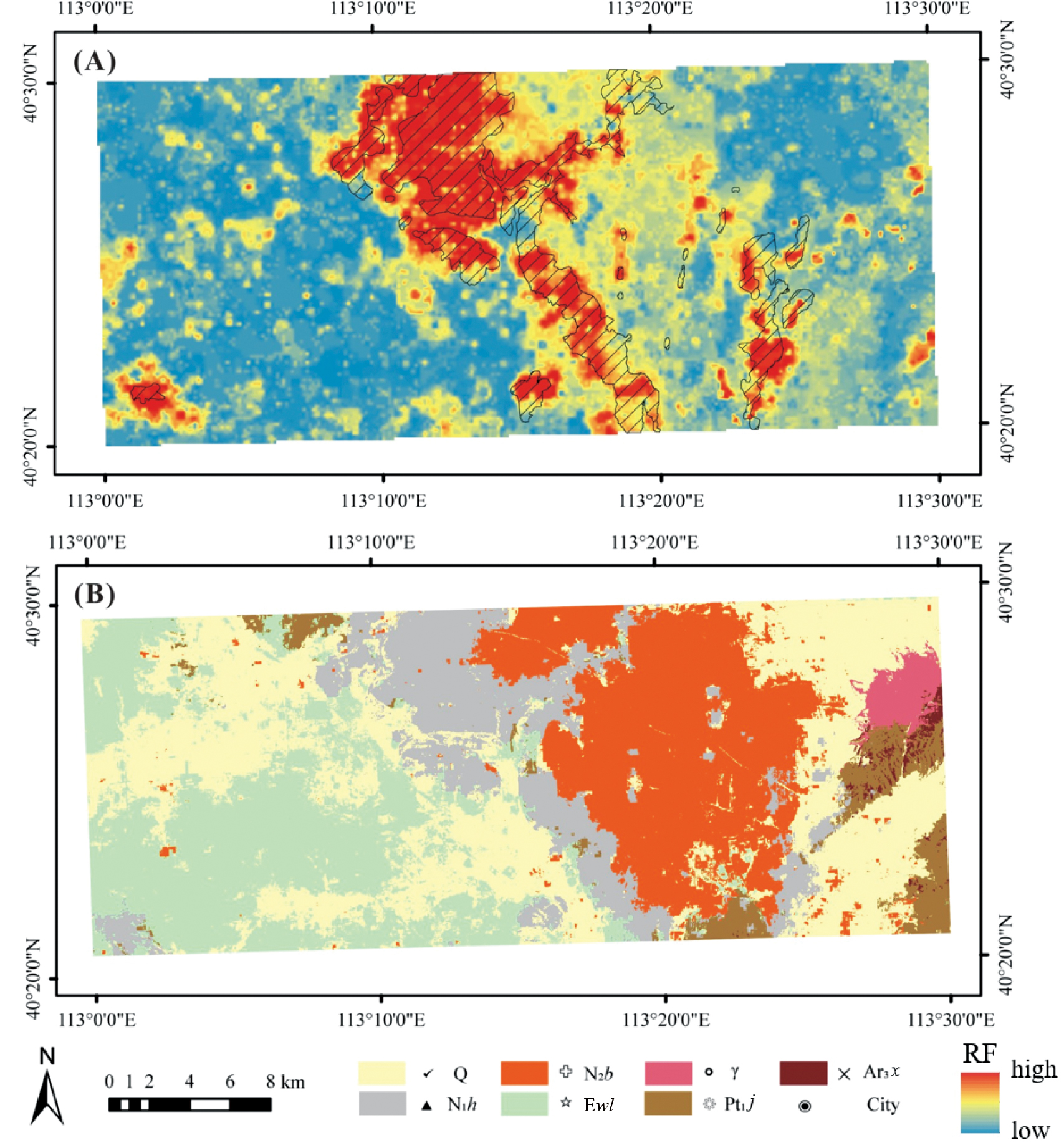
Fig.3 Lithology distribution prediction through integration of geochemical and AEF data. (A) Stream sediment geochemical data at 1∶50,000 scale, showing the distribution of basalt predicted by the element combination calculated using principal component analysis (Ge et al., 2022). (B) Lithology identification results from fused geochemical and AEF data. Q: Quaternary; N1h: Hannuoba Basalt; N2b: Neogene Baogedawula Formation; Ewl: Paleogene Wulangechu Formation; γ: Yanshanian granite; Pt1j: Paleoproterozoic Jining Group; Ar3x: Neoarchean Xinghe Group.
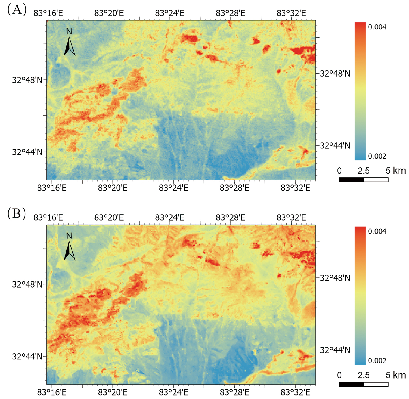
Fig.4 Delineation of mineralized alteration zones in the Duolong ore district, Tibet. (A) Erosion Index distribution map extracted from ASTER imagery (modified from Fu et al., 2021); (B) Erosion Index distribution map derived from random forest regression using AEF data.
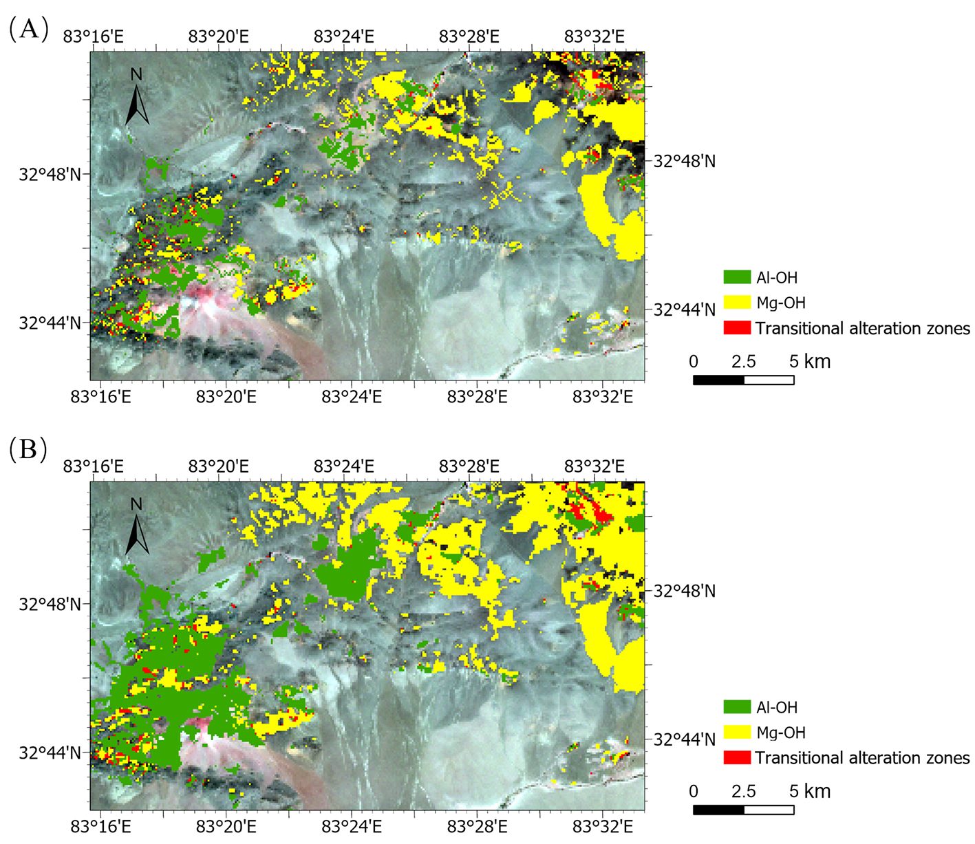
Fig.5 (A) Alteration mineral classification map derived from ASTER imagery; (B) Alteration mineral information distribution map extracted using a random forest multi-regression model based on AEF data.

Fig.6 Comprehensive surface change intensity map (Δθ, unit: degrees) around Mayon Volcano, Philippines, for 2018 relative to 2017, calculated using AEF data.

Fig.7 Estimation of river suspended sediment concentration in the Pearl River Delta using Landsat 8 and AEF data, respectively. (A) Results derived from Landsat 8 data; (B) Results derived from AEF data.
| [1] | Agterberg, F.P., 1974. Geomathematics. Elsevier, Amsterdam. |
| [2] | Anderson, S., Gislason, S., 2011. Geochemistry of the Earth’s surface. Applied Geochemistry, 26: S1-S2. |
| [3] | Asif, R., 2025. Meet AlphaEarth Foundations: Google DeepMind’s so called ‘virtual satellite’ in AI-driven planetary mapping. https://www.marktechpost.com/2025/07/31/meet-alphaearth-foundations. |
| [4] | Banerjee, S., Carlin, B.P., Gelfand, A.E., 2014. Hierarchical Modeling and analysis for spatial data. CRC Press, Boca Raton. |
| [5] | Boone, A., 2025. Google’s newest AI acts like a satellite to track climate change. https://www.wired.com/story/googles-newest-ai-model-acts-like-asatellite-to-track-climate-change. |
| [6] | Brown, C.F., Kazmierski, M.R., Pasquarella, V.J., et al., 2025. AlphaEarth Foundations: an embedding field model for accurate and efficient global mapping from sparse label data. https://doi.org/10.48550/arXiv.2507.22291. |
| [7] | Carranza, E.J.M., 2008. Geochemical anomaly and mineral prospectivity mapping in GIS. In:Handbook of exploration and environmental geochemistry. Elsevier, Amsterdam. |
| [8] | Cheng, Q.M., Agterberg, F.P, 1999. Fuzzy weights of evidence method and its application in mineral potential mapping. Natural Resources Research, 8(1): 27-35. |
| [9] | Cheng, Q.M., 2018. Mathematical geosciences:local singularity analysis of nonlinear Earth systems. In:Daya Sagar, B., Cheng, Q., Agterberg, F. (Eds.), Handbook of mathematical geosciences. Springer, Cham, pp. 179-208. |
| [10] | Cheng, Q.M., 2021a. IUGS’ initiative on data-driven geoscience discovery. Journal of Earth Science, 32(2): 468-470. |
| [11] | Cheng, Q.M., 2021b. Whatis mathematical geoscience and its cutting-edge fields? Earth Science Frontiers, 28(3): 6-25. (in Chinese with English abstract) |
| [12] | Cheng, Q.M., Oberhnsli, R., Zhao, M.L., 2020. A new international initiative for facilitating data-driven Earth science transformation. Geological Society, London, Special Publications, 499(1): 225-240. |
| [13] | Cracknell, A.P., 1998. Synergy in remote sensing: what’s in a pixel? International Journal of Remote Sensing, 19(11): 2025-2047. |
| [14] | Cressie, N., Wikle, C.K., 2011. Statistics for spatio-temporal data. Wiley, New York. |
| [15] | Daya Sagar, B., Cheng, Q., Agterberg, F. (Eds.), 2018. Handbook of mathematical geosciences. Springer, Cham. |
| [16] | DeepMind, 2025a. AlphaEarth Foundations helps map our planet in unprecedented detail. https://deepmind.google/discover/blog/alphaearth-foundations-helps-map-our-planet-in-unprecedented-detail/. |
| [17] | DeepMind, 2025b. Dataset release: satellite embedding V1 annual (2017-2024). Google Earth Engine. https://developers.google.com/earth-engine/datasets/catalog/GOOGLE_SATELLITE_EMBEDDING_V1_ANNUAL. |
| [18] | Dentith, M., Mudge, S.T., 2014. Geophysics for the mineral exploration geoscientist. Cambridge University Press, Cambridge. |
| [19] | Drusch, M., Del Bello, U., Carlier, S., et al., 2012. Sentinel-2: ESA’s optical high-resolution mission for GMES operational services. Remote Sensing of Environment, 120(15): 25-36. |
| [20] | Drury, S.A., 1987. Image interpretation in geology. Allen & Unwin, Sydney. |
| [21] | Fu, H.Z., Cheng, Q.M., Jing, L.H., et al. 2021. Deep learning-based hydrothermal alteration mapping using GaoFen-5 hyperspectral data in the Duolong Ore District, Western Tibet, China. Journal of Applied Remote Sensing, 15(4): 044512. |
| [22] | Fu, H.Z., Kereszturi, G., Cheng, Q.M., et al. 2024. Deciphering differential exhumation in the Gangdese orogen in southern Tibet using exposed porphyry alteration systems and geomorphic analysis. Geological Society of America Bulletin, 136(9/10): 3795-3809. |
| [23] | Gillespie, A.R., Kahle, A.B., Walker, R.E., 1986. Color enhancement of highly correlated images. I. Decorrelation and HSI contrast stretches. Remote Sensing of Environment, 20(3): 209-235. |
| [24] | Ge, Y.Z., Zhang, Z.J., Cheng, Q.M., et al. 2022. Geological mapping of basalt using stream sediment geochemical data: case study of covered areas in Jining, Inner Mongolia, China. Journal of Geochemical Exploration, 232: 106888. |
| [25] | Goetz, A.F.H., Vane, G., Solomon, J.E., et al. 1985. Imaging spectrometry for Earth remote sensing. Science, 228(4704): 1147-1153. |
| [26] | Goodchild, M.F., Li, L., 2021. Replication across space and time must be weak in the social and environmental sciences. PNAS, 118(35): e2015759118. |
| [27] | Hinze, W.J., von Frese, R.R.B., Saad, A.H., 2013. Gravity and magnetic exploration:principles, practices, and applications. Cambridge University Press, Cambridge. |
| [28] | Houriez, L., Pilarski, S., Vahedi, B., et al. 2025. Scalable geospatial data generation using AlphaEarth Foundations model. https://arxiv.org/abs/2508.11739. |
| [29] | Hunt, G.R., 1977. Spectral signatures of particulate minerals in the visible and near infrared. Geophysics, 42(3): 501-513. |
| [30] | Joyce, K.E., Belliss, S.E., Samsonov, S.V., et al. 2009. A review of the status of satellite remote sensing and image processing techniques for mapping natural hazards and disasters. Progress in Physical Geography, 33(2): 183-207. |
| [31] | Jordan, M.I., Mitchell, T.M., 2015. Machine learning: trends, perspectives, and prospects. Science, 349(6245): 255-260. |
| [32] | Karpatne, A., Atluri, G., Faghmoous, J.H., et al. 2017. Theory-guided data science: a new paradigm for scientific discovery. IEEE TKDE, 29(10): 2318-2331. |
| [33] | Kim, Y., Nakata, N., 2018. Geophysical inversion versus machine learning in inverse problems. The Leading Edge, 37: 894-901. |
| [34] | LeCun, Y., Bengio, Y., Hinton, G., 2015. Deep learning. Nature, 521(7553): 436-444. |
| [35] | Lucía, G.D., 2025. From imagery to insight: Google AlphaEarth Foundations in CARTO. https://carto.com/blog/google-alphaearth-foundations-in-carto. |
| [36] | Michael, N., 2025. GoogleDeepMind says its new AI can map the entire planet with unprecedented accuracy. https://venturebeat.com/ai/googledeepmind-says-its-new-ai-can-map-the-entire-planet-withunprecedented-accuracy. |
| [37] | Oberhnsli, R., 2020. Deep-time Digital Earth (DDE) the First IUGS Big Science Program. Journal of the Geological Society of India, 95(3): 223-226. |
| [38] | Pasquarella, V., Schechter, E., 2025. AI-powered pixels: introducing Google’s satellite embedding dataset. https://venturebeat.com/ai/googledeepmind-says-its-new-ai-can-map-the-entire-planet-withunprecedented-accuracy |
| [39] | Reichstein, M., Camps-Valls, G., Stevens, B., et al. 2019. Deep learning and process understanding for data-driven Earth system science. Nature, 566(7743): 195-204. |
| [40] | Rodriguez-Galiano, V., Sanchez-Castillo, M., Chica-Olmo, M., et al. 2015. Machine learning predictive models for mineral prospectivity: An evaluation of neural networks, random forest, regression trees and support vector machines. Ore Geology Reviews, 71: 804-818. |
| [41] | Singh, A., 1989. Digital change detection techniques using remotely-sensed data. International Journal of Remote Sensing, 10(6): 989-1003. |
| [42] | Smith, D.B., Cannon, W.F., Woodruff, L.G., et al. 2013. Geochemical and mineralogical data for soils of the conterminous United States. US Geological Survey Data Series, Reston, 801: 19. |
| [43] | Stephenson, M.H., Cheng, Q.M., Wang, C.S., et al. 2020. Progress towards the establishment of the IUGS Deep-time Digital Earth (DDE) programme. Episodes, 43: 1057-1062. |
| [44] | Wilkinson, M.D., Dumontier, M., Aalbersberg, I.J.J., et al. 2016. The FAIR guiding principles for scientific data management and stewardship. Scientific Data, 3(1): 1-9. |
| [45] | Wulder, M.A., Masek, J.G., Cohen, W.B., et al. 2012. Opening the archive: How free data has enabled the science and monitoring promise of Landsat. Remote Sensing of Environment, 122: 2-10. |
| [46] | Zhao, T., Wang, S., Ouyang, C.J., et al. 2024. Artificial intelligence for geoscience: progress, challenges, and perspectives. The Innovation, 5(5): 100691. |
| [1] | YUE Dali, LI Wei, WANG Wurong, WU Shenghe, LI Honghui, LIU Jingyang, LIU Lei, XU Zimo, LIN Jin, WU Guangzhen. Advances and prospects of meandering river sedimentary architecture research [J]. Earth Science Frontiers, 2025, 32(5): 113-130. |
| [2] | CHENG Qiuming, YANG Yilin, ZHOU Yuanzhi, ZHANG Yuanzhi. Earth science in the era of foundation models: How AlphaEarth is reshaping quantitative geoscience [J]. Earth Science Frontiers, 2025, 32(5): 1-11. |
| [3] | ZHOU Shengquan, LI Yike, WANG Yongzhi, LIU Haiming, LI Nan, KE Changhui, LI Ruiping, ZHAO Yonggang, ZHANG Li. Current status and development trends of generative AI technology in Earth science research [J]. Earth Science Frontiers, 2025, 32(4): 303-316. |
| [4] | CHEN Guoxiong, ZHANG Yuepeng, LUO Lei, XIA Qinglin, CHENG Qiuming. Data-driven spatio-temporal prediction model of porphyry deposits [J]. Earth Science Frontiers, 2025, 32(4): 46-59. |
| [5] | DONG Yuhao, WANG Yongzhi, TIAN Jiangtao, WANG Cheng, WEN Shibo, LI Bowen. Research progress on porphyry copper deposit prediction based on knowledge graphs [J]. Earth Science Frontiers, 2025, 32(4): 280-290. |
| [6] | CHENG Qiuming. A new paradigm for mineral resource prediction based on human intelligence-artificial intelligence Integration [J]. Earth Science Frontiers, 2025, 32(4): 1-19. |
| [7] | ZHU Biaobiao, CAO Wei, YU Pengpeng, ZHANG Qianlong, GUO Lanxuan, YUAN Guiqiang, HAN Feng, WANG Hanyu, ZHOU Yongzhang. Research hotspots and cutting-edge analysis of geological big data and artificial intelligence based on CiteSpace [J]. Earth Science Frontiers, 2024, 31(4): 73-86. |
| [8] | GU Hao, YANG Zeqiang, GAO Meng, TANG Xiangwei, WANG Dongxiao, LIU Kuisong, YANG Shuren, GUO Yueshan, WANG Yun, WANG Gongwen. Three-dimensional geological modeling and mineral prospectivity mapping in the Weishancheng gold-silver district, Henan, China [J]. Earth Science Frontiers, 2024, 31(3): 245-259. |
| [9] | SHEN Guoqiang, WANG Yumei, ZHANG Fanchang, ZHANG Hong, WANG Xiping, CHEN Songli. Identification of Triassic polyhalite in Northeast Sichuan by AI-based seismic inversion [J]. Earth Science Frontiers, 2021, 28(6): 155-161. |
| Viewed | ||||||
|
Full text |
|
|||||
|
Abstract |
|
|||||