Earth Science Frontiers ›› 2024, Vol. 31 ›› Issue (3): 245-259.DOI: 10.13745/j.esf.sf.2023.6.8
Previous Articles Next Articles
GU Hao1,2( ), YANG Zeqiang1,2, GAO Meng3(), TANG Xiangwei1, WANG Dongxiao1, LIU Kuisong1,2, YANG Shuren3, GUO Yueshan1, WANG Yun1,2, WANG Gongwen3,4,5,*()
Received:2022-11-19
Revised:2023-06-12
Online:2024-05-25
Published:2024-05-25
CLC Number:
GU Hao, YANG Zeqiang, GAO Meng, TANG Xiangwei, WANG Dongxiao, LIU Kuisong, YANG Shuren, GUO Yueshan, WANG Yun, WANG Gongwen. Three-dimensional geological modeling and mineral prospectivity mapping in the Weishancheng gold-silver district, Henan, China[J]. Earth Science Frontiers, 2024, 31(3): 245-259.

Fig.1 Geological rough sketch of ore concentration area in Weishancheng. A—the geotectonic location of the ore-concentrated area; B—geological sketch map of ore-concentrated area.

Fig.2 Metallogenic model of gold and silver deposits in Weishancheng Mining Area
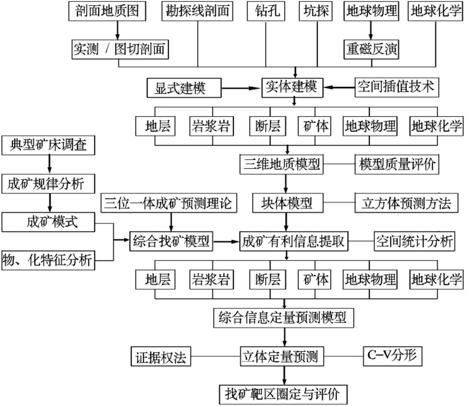
Fig.3 3D geological modeling and quantitative prediction technology process
| 数据来源 | 磁测总 精度/nT | 野外观测均方误差/nT | 基点、高程及正常场改正误差/nT | |||||||
|---|---|---|---|---|---|---|---|---|---|---|
| 总计 | 操作及 点位差 | 仪器一 致性差 | 仪器噪 声误差 | 日变改 正误差 | 总计 | 正常场 改正差 | 高程改 正误差 | 总基点 改正差 | ||
| 本次测量 | 2.02 | 1.551 | 1.241 | 0.872 | 0.24 | 0.216 | 1.293 | 0.3 | 0.788 | 0.98 |
| DZ/T 0071—1993 | 5 | 4.36 | 2.65 | 2.0 | 2.0 | 2.0 | 2.45 | 1.0 | 1.0 | 2.0 |
Table 1 Statistical results of errors in magnetic measurement
| 数据来源 | 磁测总 精度/nT | 野外观测均方误差/nT | 基点、高程及正常场改正误差/nT | |||||||
|---|---|---|---|---|---|---|---|---|---|---|
| 总计 | 操作及 点位差 | 仪器一 致性差 | 仪器噪 声误差 | 日变改 正误差 | 总计 | 正常场 改正差 | 高程改 正误差 | 总基点 改正差 | ||
| 本次测量 | 2.02 | 1.551 | 1.241 | 0.872 | 0.24 | 0.216 | 1.293 | 0.3 | 0.788 | 0.98 |
| DZ/T 0071—1993 | 5 | 4.36 | 2.65 | 2.0 | 2.0 | 2.0 | 2.45 | 1.0 | 1.0 | 2.0 |

Fig.4 Relationship between 3D geological model and orebody

Fig.5 Three-dimensional geophysics model
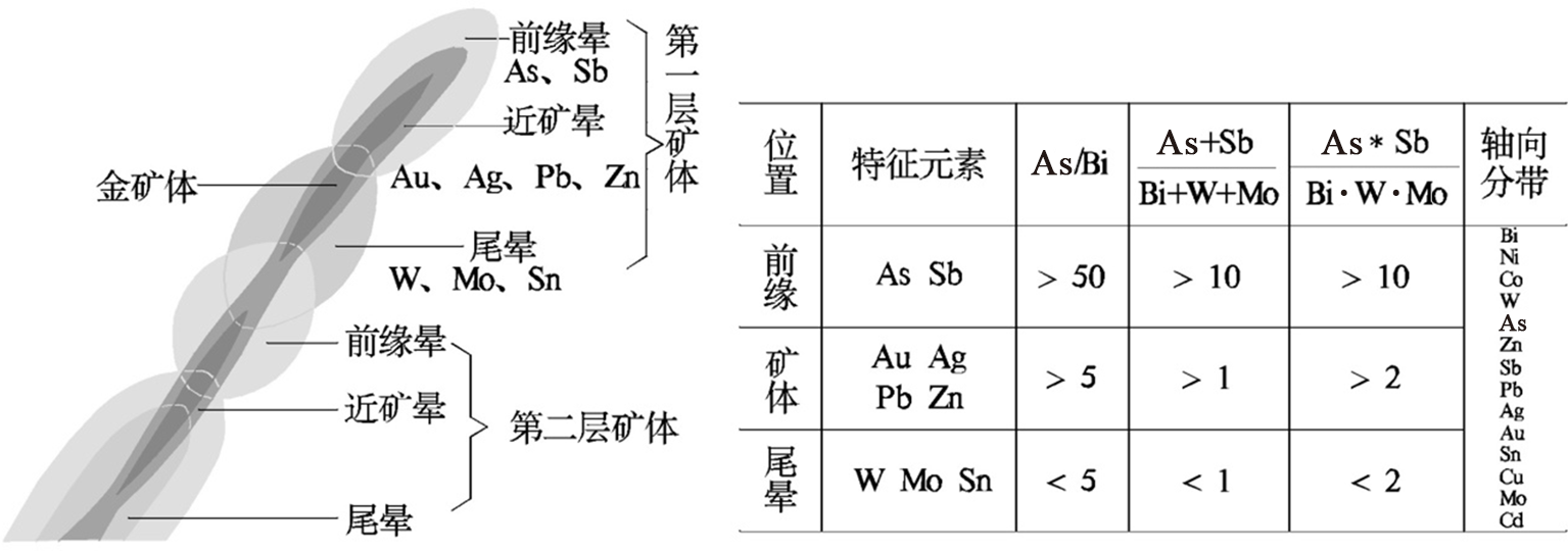
Fig.6 Vertical and axial zoning characteristics of ore-forming elements in Yindongpo gold deposit

Fig.7 DSI interpolation model for different geochemical elements
| 矿床类型 | 控矿因素 | 定量化预测要素 | 矿床实例 | |
|---|---|---|---|---|
| 岩浆热 液型 | 地层 | 歪头山组为赋矿岩层,特别是碳质 绢云石英片岩为主要赋矿围岩 | 二段第一岩性层  | 银洞坡金矿、 破山银矿 |
二段第二岩性层  | ||||
| 三段第二岩性层 | ||||
| 碳质层 | ||||
| 构造 | 朱庄背形构造层间破碎带 | 断裂带 | ||
| 岩浆岩 | 隐伏酸性岩体 | 岩体 | ||
| 地球 物理 | 矿床出现在负重力异常带上 | 低密度 | ||
| 矿床分布在低缓磁异常内 | 低磁化率 | |||
| 矿床显示低电阻率、高激化率 | 低电阻率、高激化率 | |||
| 地球 化学 | 主要元素组合为Au、Ag、Pb、Zn、As、Sb | Au | ||
| Ag | ||||
| Pb | ||||
| Zn | ||||
| As | ||||
| Sb | ||||
Table 2 Comprehensive information quantitative prediction model
| 矿床类型 | 控矿因素 | 定量化预测要素 | 矿床实例 | |
|---|---|---|---|---|
| 岩浆热 液型 | 地层 | 歪头山组为赋矿岩层,特别是碳质 绢云石英片岩为主要赋矿围岩 | 二段第一岩性层 | 银洞坡金矿、 破山银矿 |
| 二段第二岩性层 | ||||
| 三段第二岩性层 | ||||
| 碳质层 | ||||
| 构造 | 朱庄背形构造层间破碎带 | 断裂带 | ||
| 岩浆岩 | 隐伏酸性岩体 | 岩体 | ||
| 地球 物理 | 矿床出现在负重力异常带上 | 低密度 | ||
| 矿床分布在低缓磁异常内 | 低磁化率 | |||
| 矿床显示低电阻率、高激化率 | 低电阻率、高激化率 | |||
| 地球 化学 | 主要元素组合为Au、Ag、Pb、Zn、As、Sb | Au | ||
| Ag | ||||
| Pb | ||||
| Zn | ||||
| As | ||||
| Sb | ||||
| 矿种 | 赋矿地层 | 矿体编号 | 矿体规模 | 占比/ % |
|---|---|---|---|---|
| 银多 金属 矿 |  | A7 | 薄层状延伸短 | 2.5 |
| | A8 | 薄层状延伸短 | 2.5 | |
 | A1,A2,A3,A4,A5, A6,A9,A6-2 | 厚层状断续 分布延长远 | 20 | |
 | A10,A10-2 | 薄层状延伸短 | 5 | |
| | A11,A12 | 薄层状延伸短 | 5 | |
| 铅锌矿 |  | A68,A70 | 薄层状延伸短 | 5 |
 | A73,A75 | 薄层状延伸短 | 5 | |
| 金多 金属 矿 |  | 51,51-1 | 薄层状延伸短 | 5 |
| | 52,52-1,52-2,52-3, 53,54,54-1,55,55-1, 56,57,3,3-1,3-2 | 厚层状断续 分布延长远 | 35 | |
 | 1,1-1,1-2,1-3 | 厚层状断续 分布延长远 | 10 | |
 | Au-15 | 薄层状延伸短 | 2.5 | |
| | Au-5 | 薄层状延伸短 | 2.5 |
Table 3 Statistical table of ore-bearing property of different ore-bearing strata
| 矿种 | 赋矿地层 | 矿体编号 | 矿体规模 | 占比/ % |
|---|---|---|---|---|
| 银多 金属 矿 | | A7 | 薄层状延伸短 | 2.5 |
| | A8 | 薄层状延伸短 | 2.5 | |
| | A1,A2,A3,A4,A5, A6,A9,A6-2 | 厚层状断续 分布延长远 | 20 | |
| | A10,A10-2 | 薄层状延伸短 | 5 | |
| | A11,A12 | 薄层状延伸短 | 5 | |
| 铅锌矿 | | A68,A70 | 薄层状延伸短 | 5 |
| | A73,A75 | 薄层状延伸短 | 5 | |
| 金多 金属 矿 | | 51,51-1 | 薄层状延伸短 | 5 |
| | 52,52-1,52-2,52-3, 53,54,54-1,55,55-1, 56,57,3,3-1,3-2 | 厚层状断续 分布延长远 | 35 | |
| | 1,1-1,1-2,1-3 | 厚层状断续 分布延长远 | 10 | |
| | Au-15 | 薄层状延伸短 | 2.5 | |
| | Au-5 | 薄层状延伸短 | 2.5 |

Fig.8 The relationship between density body, low magnet, and ore-bearing strata
| 信息类型 | 特征变量 | 描述 | 类型 | 值域 | 单元数量 | |
|---|---|---|---|---|---|---|
| 地质 实体 信息 量 |  | 歪头山组上部二岩段 | 二值型 | 0,1 | 39 317 | |
 | 歪头山组中部二岩段 | 二值型 | 0,1 | 120 615 | ||
 | 歪头山组中部一岩段 | 二值型 | 0,1 | 130 777 | ||
| SC | 碳质绢云石英片岩 | 二值型 | 0,1 | 103 537 | ||
| ηγ | 隐伏酸性岩体 | 二值型 | 0,1 | 72 868 | ||
| F | 断裂 | 二值型 | 0,1 | 147 807 | ||
| Au找 矿属 性信 息量 | EH4_ρs | EH4_视电阻率 | 连续型 | 94.751 4,2 724.098 9 | 149 865 | |
| 磁化率 | 磁化率 | 连续型 | 0.004 7,0.011 8 | 418 361 | ||
| 密度 | 密度 | 连续型 | 2.373 7,2.438 9 | 376 736 | ||
| Au | Ag品位插值 | 连续型 | 0.237 7,10.099 6 | 31 946 | ||
| As | As品位插值 | 连续型 | 0.016 1,0.625 8 | 31 652 | ||
| Sb | Sb品位插值 | 连续型 | 0.000 1,0.000 8 | 137 683 | ||
| Ag找 矿属 性信 息量 | EH4_ρs | EH4_视电阻率 | 连续型 | 94.751 4,2 079.913 4 | 594 854 | |
| 磁化率 | 磁化率 | 连续型 | 0.004 7,0.019 2 | 157 569 | ||
| 密度 | 视密度 | 连续型 | 2.413 9,2.489 0 | 487 082 | ||
| Ag | Ag品位插值 | 连续型 | 16.174 9,442.751 3 | 47 590 | ||
| As | As品位插值 | 连续型 | 0.016 1,0.625 8 | 31 652 | ||
| Sb | Sb品位插值 | 连续型 | 0.000 1,0.000 8 | 137 683 | ||
Table 4 Comprehensive information quantitative prediction model
| 信息类型 | 特征变量 | 描述 | 类型 | 值域 | 单元数量 | |
|---|---|---|---|---|---|---|
| 地质 实体 信息 量 | | 歪头山组上部二岩段 | 二值型 | 0,1 | 39 317 | |
| | 歪头山组中部二岩段 | 二值型 | 0,1 | 120 615 | ||
| | 歪头山组中部一岩段 | 二值型 | 0,1 | 130 777 | ||
| SC | 碳质绢云石英片岩 | 二值型 | 0,1 | 103 537 | ||
| ηγ | 隐伏酸性岩体 | 二值型 | 0,1 | 72 868 | ||
| F | 断裂 | 二值型 | 0,1 | 147 807 | ||
| Au找 矿属 性信 息量 | EH4_ρs | EH4_视电阻率 | 连续型 | 94.751 4,2 724.098 9 | 149 865 | |
| 磁化率 | 磁化率 | 连续型 | 0.004 7,0.011 8 | 418 361 | ||
| 密度 | 密度 | 连续型 | 2.373 7,2.438 9 | 376 736 | ||
| Au | Ag品位插值 | 连续型 | 0.237 7,10.099 6 | 31 946 | ||
| As | As品位插值 | 连续型 | 0.016 1,0.625 8 | 31 652 | ||
| Sb | Sb品位插值 | 连续型 | 0.000 1,0.000 8 | 137 683 | ||
| Ag找 矿属 性信 息量 | EH4_ρs | EH4_视电阻率 | 连续型 | 94.751 4,2 079.913 4 | 594 854 | |
| 磁化率 | 磁化率 | 连续型 | 0.004 7,0.019 2 | 157 569 | ||
| 密度 | 视密度 | 连续型 | 2.413 9,2.489 0 | 487 082 | ||
| Ag | Ag品位插值 | 连续型 | 16.174 9,442.751 3 | 47 590 | ||
| As | As品位插值 | 连续型 | 0.016 1,0.625 8 | 31 652 | ||
| Sb | Sb品位插值 | 连续型 | 0.000 1,0.000 8 | 137 683 | ||
| 序号 | Layer | W+ | s(W+) | W- | s(W-) | C | s(C) | t-value |
|---|---|---|---|---|---|---|---|---|
| 1 |  | 2.113 1 | 0.013 5 | -0.869 0 | 0.016 6 | 2.982 1 | 0.021 4 | 139.264 8 |
| 2 | EH4_ρs | 1.875 8 | 0.014 0 | -0.748 1 | 0.015 7 | 2.623 9 | 0.021 0 | 124.690 5 |
| 3 | As | 2.669 2 | 0.020 9 | -0.291 2 | 0.012 1 | 2.960 4 | 0.024 1 | 122.697 1 |
| 4 | SC | 1.993 3 | 0.015 5 | -0.557 7 | 0.014 1 | 2.551 0 | 0.021 0 | 121.621 9 |
| 5 | F | 1.774 0 | 0.014 4 | -0.673 4 | 0.015 2 | 2.447 4 | 0.020 9 | 117.109 4 |
| 6 | Sb | 2.412 5 | 0.023 3 | -0.216 8 | 0.011 6 | 2.629 3 | 0.026 0 | 100.935 0 |
| 7 | Au | 2.341 4 | 0.024 0 | -0.199 7 | 0.011 5 | 2.541 1 | 0.026 7 | 95.290 7 |
| 8 | 密度 | 1.099 4 | 0.012 4 | -0.973 3 | 0.019 3 | 2.072 7 | 0.022 9 | 90.606 0 |
| 9 |  | 1.429 5 | 0.017 9 | -0.333 9 | 0.012 8 | 1.763 4 | 0.022 0 | 80.310 0 |
| 10 | 磁化率 | 0.747 3 | 0.014 1 | -0.489 2 | 0.015 3 | 1.236 5 | 0.020 8 | 59.395 0 |
| 11 | | -5.458 9 | 1.000 0 | 0.025 2 | 0.010 4 | -5.484 1 | 1.000 1 | -5.483 7 |
Table 5 Weight table of each predictive variable of Au evidence weight method
| 序号 | Layer | W+ | s(W+) | W- | s(W-) | C | s(C) | t-value |
|---|---|---|---|---|---|---|---|---|
| 1 | | 2.113 1 | 0.013 5 | -0.869 0 | 0.016 6 | 2.982 1 | 0.021 4 | 139.264 8 |
| 2 | EH4_ρs | 1.875 8 | 0.014 0 | -0.748 1 | 0.015 7 | 2.623 9 | 0.021 0 | 124.690 5 |
| 3 | As | 2.669 2 | 0.020 9 | -0.291 2 | 0.012 1 | 2.960 4 | 0.024 1 | 122.697 1 |
| 4 | SC | 1.993 3 | 0.015 5 | -0.557 7 | 0.014 1 | 2.551 0 | 0.021 0 | 121.621 9 |
| 5 | F | 1.774 0 | 0.014 4 | -0.673 4 | 0.015 2 | 2.447 4 | 0.020 9 | 117.109 4 |
| 6 | Sb | 2.412 5 | 0.023 3 | -0.216 8 | 0.011 6 | 2.629 3 | 0.026 0 | 100.935 0 |
| 7 | Au | 2.341 4 | 0.024 0 | -0.199 7 | 0.011 5 | 2.541 1 | 0.026 7 | 95.290 7 |
| 8 | 密度 | 1.099 4 | 0.012 4 | -0.973 3 | 0.019 3 | 2.072 7 | 0.022 9 | 90.606 0 |
| 9 | | 1.429 5 | 0.017 9 | -0.333 9 | 0.012 8 | 1.763 4 | 0.022 0 | 80.310 0 |
| 10 | 磁化率 | 0.747 3 | 0.014 1 | -0.489 2 | 0.015 3 | 1.236 5 | 0.020 8 | 59.395 0 |
| 11 | | -5.458 9 | 1.000 0 | 0.025 2 | 0.010 4 | -5.484 1 | 1.000 1 | -5.483 7 |
| 序号 | Layer | W+ | s(W+) | W- | s(W-) | C | s(C) | t-value |
|---|---|---|---|---|---|---|---|---|
| 1 |  | 2.582 8 | 0.031 6 | -0.362 5 | 0.021 4 | 2.945 3 | 0.038 2 | 77.105 3 |
| 2 | SC | 1.989 7 | 0.025 9 | -0.575 1 | 0.024 4 | 2.564 8 | 0.035 5 | 72.196 7 |
| 3 | Ag | 2.385 9 | 0.031 6 | -0.355 0 | 0.021 4 | 2.740 9 | 0.038 2 | 71.779 8 |
| 4 | Sb | 1.164 8 | 0.021 6 | -0.874 2 | 0.030 8 | 2.039 0 | 0.037 6 | 54.209 4 |
| 5 | 磁化率 | 1.369 3 | 0.028 4 | -0.391 0 | 0.022 6 | 1.760 3 | 0.036 3 | 48.495 5 |
| 6 | 密度 | 0.913 1 | 0.020 2 | -1.100 5 | 0.036 8 | 2.013 7 | 0.042 0 | 47.931 1 |
| 7 | As | 2.114 1 | 0.044 1 | -0.158 2 | 0.019 3 | 2.272 3 | 0.048 2 | 47.186 2 |
| 8 | F | 1.106 3 | 0.033 3 | -0.233 7 | 0.020 9 | 1.340 0 | 0.039 3 | 34.063 9 |
| 9 | EH4_ρs | 1.247 2 | 0.038 9 | -0.171 3 | 0.019 9 | 1.418 5 | 0.043 7 | 32.482 2 |
| 10 |  | -4.495 2 | 0.577 4 | 0.086 6 | 0.017 7 | -4.581 8 | 0.577 6 | -7.932 1 |
| 11 |  | -1.402 8 | 0.128 1 | 0.061 3 | 0.017 9 | -1.464 2 | 0.129 3 | -11.323 0 |
Table 6 Weight table of each predictive variable of Ag evidence weight method
| 序号 | Layer | W+ | s(W+) | W- | s(W-) | C | s(C) | t-value |
|---|---|---|---|---|---|---|---|---|
| 1 | | 2.582 8 | 0.031 6 | -0.362 5 | 0.021 4 | 2.945 3 | 0.038 2 | 77.105 3 |
| 2 | SC | 1.989 7 | 0.025 9 | -0.575 1 | 0.024 4 | 2.564 8 | 0.035 5 | 72.196 7 |
| 3 | Ag | 2.385 9 | 0.031 6 | -0.355 0 | 0.021 4 | 2.740 9 | 0.038 2 | 71.779 8 |
| 4 | Sb | 1.164 8 | 0.021 6 | -0.874 2 | 0.030 8 | 2.039 0 | 0.037 6 | 54.209 4 |
| 5 | 磁化率 | 1.369 3 | 0.028 4 | -0.391 0 | 0.022 6 | 1.760 3 | 0.036 3 | 48.495 5 |
| 6 | 密度 | 0.913 1 | 0.020 2 | -1.100 5 | 0.036 8 | 2.013 7 | 0.042 0 | 47.931 1 |
| 7 | As | 2.114 1 | 0.044 1 | -0.158 2 | 0.019 3 | 2.272 3 | 0.048 2 | 47.186 2 |
| 8 | F | 1.106 3 | 0.033 3 | -0.233 7 | 0.020 9 | 1.340 0 | 0.039 3 | 34.063 9 |
| 9 | EH4_ρs | 1.247 2 | 0.038 9 | -0.171 3 | 0.019 9 | 1.418 5 | 0.043 7 | 32.482 2 |
| 10 | | -4.495 2 | 0.577 4 | 0.086 6 | 0.017 7 | -4.581 8 | 0.577 6 | -7.932 1 |
| 11 | | -1.402 8 | 0.128 1 | 0.061 3 | 0.017 9 | -1.464 2 | 0.129 3 | -11.323 0 |
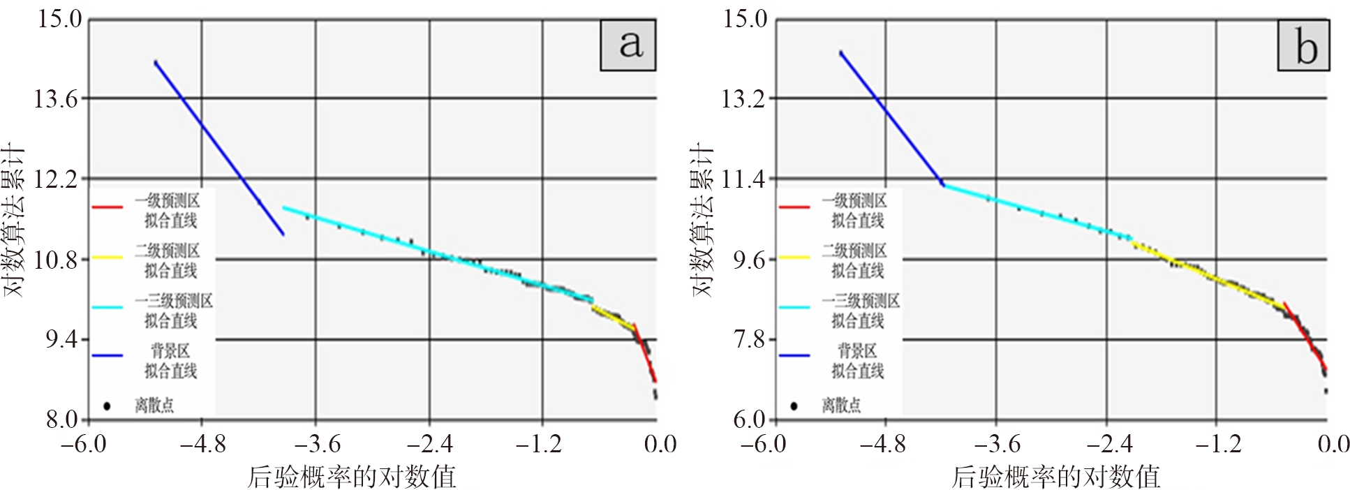
Fig.9 Fractal piecewise fitting line of Au, Ag evidence weight method

Fig.10 The predicts result of Au, Ag evidence weight method. a—Au prediction model; b—Ag prediction model.

Fig.11 Delineation of prospecting targets

Fig.12 Target area drilling verification results map
| [1] | 侯翠霞, 刘向冲, 张文斌, 等. 成矿预测理论与方法新进展[J]. 地质通报, 2010, 29(6): 953-960. |
| [2] | CARLSON E. Three dimensional conceptual modeling of subsurface structures[C]//Proceedings of American congress on surveying and mapping annual convention. Baltimore: American Society for Photogrammetry and Remote Sensing, 1987: 188-200. |
| [3] | SIMON W H. 3D Geoscience modeling: computer techniques for geological characterization[M]. Berlin: Springer-Verlag, 1994. |
| [4] | 赵鹏大. “三联式”资源定量预测与评价: 数字找矿理论与实践探讨[J]. 地球科学: 中国地质大学学报, 2002, 27(5): 482-489. |
| [5] | 赵鹏大, 陈建平, 张寿庭. “三联式”成矿预测新进展[J]. 地学前缘, 2003, 10(2): 455-463. |
| [6] | 王世称, 陈水良, 夏立显. 综合信息矿产预测理论与方法[M]. 北京: 科学出版社, 2002: 1-337. |
| [7] | 陈毓川、 裴荣富, 宋天锐, 等. 中国矿床成矿系列初论[M]. 北京: 地质出版社, 1998: 1-104. |
| [8] | 侯景儒, 黄竟先. 地质统计学的理论与方法[M]. 北京: 地质出版社, 1990: 1-353. |
| [9] | 余先川, 胡丹. 盲源分离理论与应用[M]. 北京: 科学出版社, 2011: 1-336. |
| [10] | 余先川, 俞晨, 侯景儒, 等. 析取克立格理论及其在品位估计中的应用[J]. 北京师范大学学报(自然科学版), 2006, 42(5): 495-497. |
| [11] | 田景文, 高美娟. 人工神经网络算法研究及应用[M]. 北京: 北京理工大学出版社, 2006: 1-283. |
| [12] | 叶天竺, 吕志成, 庞振山, 等. 勘查区找矿预测理论与方法总论[M]. 北京: 地质出版社, 2017: 1-703. |
| [13] | 叶天竺. 矿床模型综合地质信息预测技术方法理论框架[J]. 吉林大学学报(地球科学版), 2013, 43(4): 1053-1072. |
| [14] | 成秋明. 非线性成矿预测理论: 多重分形奇异性-广义自相似性-分形谱系模型与方法[J]. 地球科学: 中国地质大学学报, 2006, 31(3): 337-348. |
| [15] | WANG G W, ZHU Y Y, ZHANG S T, et al. 3D geological modeling based on geological knowledge and gravity and magnetic data inversion in Luanchuan ore region, Henan Province, China[J]. Journal of Applied Geophysics, 2012, 80: 1-11. |
| [16] | WANG G W, ZHU Y Y, ZHANG S T, et al. Application of the multifractal singular value decomposition for delineating geophysical anomalies associated with molybdenum occurrences in the Luanchuan ore field (China)[J]. Journal of Applied Geophysics, 86: 109-119. |
| [17] | 伏雄, 门道改, 李娜, 等. 河南省桐柏围山城金银矿田地质特征及找矿远景分析[J]. 矿产与地质, 2012, 26(3): 198-204. |
| [18] | 张聚. 显式模型预测控制理论与应用[M]. 北京: 电子工业出版社, 2015: 1-256. |
| [19] | MALLET J L. Discrete smooth interpolation in geometric modeling[J]. Computer-aided Design, 1992, 24(4): 178-191. |
| [20] | 孟小红, 侯建全, 梁宏英, 等. 离散光滑插值方法在地球物理位场中的快速实现[J]. 物探与化探, 2002, 26(4): 302-306. |
| [21] | 周军霞, 杨钦, 蔡强. 离散光滑插值方法在多值曲面中的应用[J]. 微计算机信息(管控一体化), 2008, 24(30): 191-192, 174. |
| [22] | OLDENBURG D W. The inversion and interpretation of gravity anomalies[J]. Geophysics, 1974, 39(4): 526-536. |
| [23] | NABIGHIAN M N. The analytic signal of two-dimensional magnetic bodies with polygonal cross-section: its properties and use for automated anomaly interpretation[J]. Geophysics, 1972, 37(3): 507-517. |
| [24] | PDLISECKY A, KNIGHT R. FW2-5D: a MATLAB 2.5-D electrical resistivity modeling code[J]. Computers and Geosciences, 2008, 34(12): 1645-1654. |
| [25] | ABUBKAR A, HABASHY T, DRUSKIN V, et al. 2.5D forward and inverse modeling for interpreting low-frequency electromagnetic measurements[J]. Geophysics, 2008, 73(4): 165-177. |
| [26] | PORTNIAGUINE O, ZHDANOV M S. 3-D magnetic inversion with data compression and image focusing[J]. Geophysics, 2002, 67(5): 1532-1541. |
| [27] | LI Y, OLDENBURG D W. 3-D inversion of magnetic data[J]. Geophysics, 1996, 61(2): 394-408. |
| [28] | LI Y, OLDENBURG D W. 3-D inversion of gravity data[J]. Geophysics, 1998, 63(1): 109-119. |
| [29] | 陈召曦, 孟小红, 郭良辉. 重磁数据三维物性反演方法进展[J]. 地球物理学进展, 2012, 27(2): 503-511. |
| [30] |
AGTERBERG F P. Computer programs for mineral exploration[J]. Science, 1989, 245(4913): 76-81.
PMID |
| [31] | BONHAM-CARTER G F, AGTERBERG F P, WRIGHT D F. Weights of evidence modeling: a new approach to mapping mineral potential[M]//AGTERBERG F P, BONHAM-CARTER G F. Statistical applications in the Earth sciences. Vancouver: Geological Survey of Canada, 1989: 171-183. |
| [32] | MANDELBROT B. The fractal geometry of nature: updated and augmented[M]. New York: Freeman and Company, 1983: 1-468. |
| [33] | CHENG Q M, AGTERBERG F P, BALLANTYNE S B. The separation of geochemical anomalies from background by fractal methods[J]. Journal of Geochemical Exploration, 1994, 51(2): 109-130. |
| [34] | 成秋明. 成矿过程奇异性与矿床多重分形分布[J]. 矿物岩石地球化学通报, 2008, 27(3): 298-305. |
| [35] | 陈志军. 多重分形局部奇异性分析方法及其在矿产资源信息提取中的应用[D]. 武汉: 中国地质大学(武汉), 2007. |
| [36] | 成秋明. 空间自相似性与地球物理和地球化学场的分解方法[J]. 地球物理学进展, 2001, 16(2): 8-17. |
| [37] | 王琨, 肖克炎, 丛源. 对数比变换和偏最小二乘法在地球化学组合异常提取中的应用: 以湘西北铅锌矿为例[J]. 物探与化探, 2015, 39(1): 141-148. |
| [38] | 董梅, 慎乃齐, 胡辉, 等. 基于GOCAD的三维地质模型构建方法[J]. 桂林工学院学报, 2008, 28(2): 188-192. |
| [39] | 张燕飞, 朱杰勇, 张威. 基于GOCAD的三维地质模型构建[J]. 河北工程大学学报(自然科学版), 2011, 28(4): 69-73. |
| [40] | 卢欣详. 河南省秦岭—大别山地区燕山期中酸性小岩体的基本地质特征及成矿专属性[J]. 河南地质, 1983, 1(1): 49-55. |
| [1] | ZHOU Yongzhang, XIAO Fan. Overview: A glimpse of the latest advances in artificial intelligence and big data geoscience research [J]. Earth Science Frontiers, 2024, 31(4): 1-6. |
| [2] | JIA Ran, WANG Haoran, WANG Gongwen, WANG Hao, XU Rongda, FENG Zhankui, SONG Yaowu, WANG Xiaoling, PANG Zong. Three-dimensional geological modeling and deep prospectivity of the Xigou Pb-Zn-Ag-Au deposit, Henan Province [J]. Earth Science Frontiers, 2021, 28(3): 156-169. |
| [3] | SHU Liang-Feng TUN Shen-Cai BO Shen. Theory of accuracy assessment and methods for error correction in 3D geological structure models. [J]. Earth Science Frontiers, 2009, 16(4): 363-371. |
| Viewed | ||||||
|
Full text |
|
|||||
|
Abstract |
|
|||||