Earth Science Frontiers ›› 2023, Vol. 30 ›› Issue (5): 526-540.DOI: 10.13745/j.esf.sf.2023.2.79
Previous Articles Next Articles
CHEN Kang1,2,3,4( ), DING Yongkang1,2,3,4,*(), ZHANG Xiaochen1,2,3,4
Received:2023-03-09
Revised:2023-04-06
Online:2023-09-25
Published:2023-10-20
CLC Number:
CHEN Kang, DING Yongkang, ZHANG Xiaochen. Spatiotemporal dynamics and control factors of vegetation cover in the Fuyang River Basin based on geographical detector model[J]. Earth Science Frontiers, 2023, 30(5): 526-540.

Fig.1 Geographical location of and distribution of meteorological stations in the Fuyang River Basin
| 覆盖分区 | NDVI |
|---|---|
| 低覆盖度区域 | 0~0.2 |
| 中低覆盖度区域 | >0.2~0.4 |
| 中覆盖度区域 | >0.4~0.6 |
| 中高覆盖度区域 | >0.6~0.8 |
| 高覆盖度区域 | >0.8~1 |
Table 1 NDVI based classification standards for vegetation status
| 覆盖分区 | NDVI |
|---|---|
| 低覆盖度区域 | 0~0.2 |
| 中低覆盖度区域 | >0.2~0.4 |
| 中覆盖度区域 | >0.4~0.6 |
| 中高覆盖度区域 | >0.6~0.8 |
| 高覆盖度区域 | >0.8~1 |
| 程度 | θslope | Z |
|---|---|---|
| 明显退化 | <-0.009 0 | <-1.96 |
| 轻度退化 | -0.009 0~<-0.000 9 | -1.96~1.96 |
| 基本稳定 | -0.000 9~<0.000 9 | 任意 |
| 轻度改善 | 0.000 9~<0.009 0 | -1.96~1.96 |
| 明显改善 | ≥0.009 0 | >1.96 |
Table 2 θslope based classification standards for vegetation growth trend
| 程度 | θslope | Z |
|---|---|---|
| 明显退化 | <-0.009 0 | <-1.96 |
| 轻度退化 | -0.009 0~<-0.000 9 | -1.96~1.96 |
| 基本稳定 | -0.000 9~<0.000 9 | 任意 |
| 轻度改善 | 0.000 9~<0.009 0 | -1.96~1.96 |
| 明显改善 | ≥0.009 0 | >1.96 |
| 判据区间 | 交互作用 |
|---|---|
| q(X1∩X2)<Min[q(X1),q(X2)] | 非线性减弱 |
| Min[q(X1), q(X2)]≤q(X1∩X2)≤Max[q(X1),q (X2)] | 单因子非线性减弱 |
| q(X1∩X2)>Max[q(X1),q (X2)] | 双因子增强 |
| q(X1∩X2)=q(X1) + q(X2) | 独立 |
| q(X1∩X2)>q(X1) + q(X2) | 非线性增强 |
Table 3 Geographical detector parameters used in this study
| 判据区间 | 交互作用 |
|---|---|
| q(X1∩X2)<Min[q(X1),q(X2)] | 非线性减弱 |
| Min[q(X1), q(X2)]≤q(X1∩X2)≤Max[q(X1),q (X2)] | 单因子非线性减弱 |
| q(X1∩X2)>Max[q(X1),q (X2)] | 双因子增强 |
| q(X1∩X2)=q(X1) + q(X2) | 独立 |
| q(X1∩X2)>q(X1) + q(X2) | 非线性增强 |
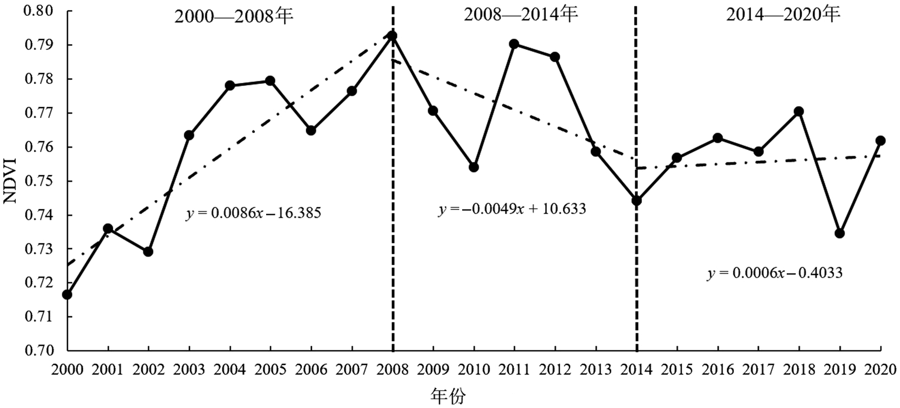
Fig.2 2000-2020 NDVI interannual trends in the Fuyang River Basin

Fig.3 Delineation of vegetation status in the Fuyang River Basin based on 2000-2020 NDVI annual means

Fig.4 Delineation of vegetation growth trends in the Fuyang River Basin based on 2000-2020 average annual trends (a), Hurst indexes (b), and calculated future trends (b)

Fig.5 Pie charts of vegetation growth trends in the Fuyang River Basin. (a) 2000-2020 average annual trends; (b) future trends.

Fig.6 2000-2020 average annual precipitation (a) and temperature (b) in the Fuyang River Basin

Fig.7 Pearson correlation coefficient maps of 2000-2020 average annual NDVI versus precipitation (a) and temperature (b) in the Fuyang River Basin

Fig.8 2000-2020 vegetation control-factor detection results on altitude (a), soil type (b), vegetation type (c), land use type (d), population density (e) and GDP (f) in the Fuyang River Basin
| 滏阳河流域植被NDVI各单驱动因子q值 | |||||||
|---|---|---|---|---|---|---|---|
| 降水 | 温度 | 海拔 | 植被类型 | 土壤类型 | 土地利用类型 | 人口密度 | GDP |
| 0.37 | 0.11 | 0.03 | 0.02 | 0.16 | 0.22 | 0.31 | 0.24 |
Table 4 q values of NDVI controlling factors in the Fuyang River Basin calculated for the 2000-2020 period
| 滏阳河流域植被NDVI各单驱动因子q值 | |||||||
|---|---|---|---|---|---|---|---|
| 降水 | 温度 | 海拔 | 植被类型 | 土壤类型 | 土地利用类型 | 人口密度 | GDP |
| 0.37 | 0.11 | 0.03 | 0.02 | 0.16 | 0.22 | 0.31 | 0.24 |
| 驱动因子 | 植被NDVI驱动因子交互组合驱动力q值 | |||||||
|---|---|---|---|---|---|---|---|---|
| 降水量 | 温度 | 海拔 | 植被类型 | 土壤类型 | 土地利用类型 | 人口密度 | GDP | |
| 降水量 | 0.37 | |||||||
| 温度 海拔 植被类型 土壤类型 土地利用类型 人口密度 GDP | 0.44 0.40 0.39 0.46 0.51 0.59 0.53 | 0.11 0.16 0.13 0.22 0.27 0.36 0.29 | 0.03 0.05 0.18 0.24 0.35 0.28 | 0.02 0.17 0.23 0.33 0.26 | 0.16 0.29 0.36 0.29 | 0.22 0.38 0.33 | 0.31 0.34 | 0.24 |
Table 5 q values of two-factor combinations for the 2000-2020 period
| 驱动因子 | 植被NDVI驱动因子交互组合驱动力q值 | |||||||
|---|---|---|---|---|---|---|---|---|
| 降水量 | 温度 | 海拔 | 植被类型 | 土壤类型 | 土地利用类型 | 人口密度 | GDP | |
| 降水量 | 0.37 | |||||||
| 温度 海拔 植被类型 土壤类型 土地利用类型 人口密度 GDP | 0.44 0.40 0.39 0.46 0.51 0.59 0.53 | 0.11 0.16 0.13 0.22 0.27 0.36 0.29 | 0.03 0.05 0.18 0.24 0.35 0.28 | 0.02 0.17 0.23 0.33 0.26 | 0.16 0.29 0.36 0.29 | 0.22 0.38 0.33 | 0.31 0.34 | 0.24 |
| 评价指标 | 植被覆盖度适宜范围(类型) | NDVI均值 |
|---|---|---|
| 降水量/mm | 464.73~500.03 | 0.763 3 |
| 温度/℃ | 15.14~15.23 | 0.748 7 |
| 海拔/m | 3~133 | 0.735 8 |
| 植被类型 | 栽培植被 | 0.826 5 |
| 土壤类型 | 初育土 | 0.760 0 |
| 土地利用类型 | 耕地 | 0.755 6 |
| 人口密度/(人·km-2) | 551.36~2 059.96 | 0.744 4 |
| GDP/(元·km-2) | 1 756.77~7 507.15 | 0.730 7 |
Table 6 Optimal conditions for vegetation growth in the Fuyang River Basin based on 2000-2020 data
| 评价指标 | 植被覆盖度适宜范围(类型) | NDVI均值 |
|---|---|---|
| 降水量/mm | 464.73~500.03 | 0.763 3 |
| 温度/℃ | 15.14~15.23 | 0.748 7 |
| 海拔/m | 3~133 | 0.735 8 |
| 植被类型 | 栽培植被 | 0.826 5 |
| 土壤类型 | 初育土 | 0.760 0 |
| 土地利用类型 | 耕地 | 0.755 6 |
| 人口密度/(人·km-2) | 551.36~2 059.96 | 0.744 4 |
| GDP/(元·km-2) | 1 756.77~7 507.15 | 0.730 7 |
| [1] | 王国帅, 孙桂凯, 魏义熊, 等. 1990—2019年澄碧河流域NDVI时空动态及驱动因素分析[J]. 水土保持研究, 2022, 29(4): 207-214. |
| [2] |
尹振良, 冯起, 王凌阁, \n 等. 2000—2019年中国西北地区植被覆盖变化及其影响因子[J]. 中国沙漠, 2022, 42(4): 11-21.
DOI |
| [3] |
TOWNSHEND J, JUSTICE C, LI W, et al. Global land cover classification by remote sensing: present capabilities and future possibilities[J]. Remote Sensing of Environment, 1991, 35(2/3): 243-255.
DOI URL |
| [4] |
ADACHI M, ITO A, YONEMURA S, et al. Estimation of global soil respiration by accounting for land-use changes derived from remote sensing data[J]. Journal of Environmental Management, 2017, 200: 97-104.
DOI PMID |
| [5] |
WEI J, HUANG W, LI Z, et al. Estimating 1-km-resolution PM2.5 concentrations across China using the space-time random forest approach[J]. Remote Sensing of Environment, 2019, 231: 111221.
DOI URL |
| [6] |
DENG C B, ZHU Z. Continuous subpixel monitoring of urban impervious surface using Landsat time series[J]. Remote Sensing of Environment, 2020, 238: 110929.
DOI URL |
| [7] |
ZHANG B H, ZHANG L, XIE D, et al. Application of synthetic NDVI time series blended from landsat and MODIS data for grassland biomass estimation[J]. Remote Sensing, 2015, 8(1): 10.
DOI URL |
| [8] |
PARUELO J M, EPSTEIN H E, LAUENROTH W K, et al. ANPP estimates from NDVI for the central grassland region of the United States[J]. Ecology, 1997, 78(3): 953-958.
DOI URL |
| [9] |
DETSCH F, OTTE I, APPELHANS T, et al. Seasonal and long-term vegetation dynamics from 1-km GIMMS-based NDVI time series at Mt. Kilimanjaro, Tanzania[J]. Remote Sensing of Environment, 2016, 178: 70-83.
DOI URL |
| [10] |
FU B, BURGHER I. Riparian vegetation NDVI dynamics and its relationship with climate, surface water and groundwater[J]. Journal of Arid Environments, 2015, 113: 59-68.
DOI URL |
| [11] |
LAMCHIN M, LEE W K, JEON S W, et al. Long-term trend and correlation between vegetation greenness and climate variables in Asia based on satellite data[J]. Science of the Total Environment, 2018, 618: 1089-1095.
DOI URL |
| [12] |
MYNENI R B, KEELING C D, TUCKER C J, et al. Increased plant growth in the northern high latitudes from 1981 to 1991[J]. Nature, 1997, 386(6626): 698-702.
DOI |
| [13] |
LUCHT W, PRENTICE I C, MYNENI R B, et al. Climatic control of the high-latitude vegetation greening trend and pinatubo effect[J]. Science, 2002, 296(5573): 1687-1689.
PMID |
| [14] | 金晓媚, 刘金韬, 夏薇. 柴达木盆地乌图美仁区植被覆盖率变化及其与地下水的关系[J]. 地学前缘, 2014, 21(4): 100-106. |
| [15] |
刘海燕, 刘茂涵, 张卫民, 等. 华北平原高氟地下水中稀土元素分布和分异特征[J]. 地学前缘, 2022, 29(3): 129-144.
DOI |
| [16] | 龚斌, 甘小莉, 刘伟玲, 等. 基于EOF分析的三江源区植被覆盖变化时空分布特征[J]. 地学前缘, 2013, 20(3): 234-239. |
| [17] | 金晓媚, 张强, 杨春杰. 海流兔河流域植被分布与地形地貌及地下水位关系研究[J]. 地学前缘, 2013, 20(3): 227-233. |
| [18] |
张亮, 丁明军, 张华敏, 等. 1982—2015年长江流域植被覆盖度时空变化分析[J]. 自然资源学报, 2018, 33(12): 2084-2097.
DOI |
| [19] | 赵子娟, 范蓓蕾, 王玉庭, 等. 2000—2018年西辽河流域植被覆盖度时空变化特征及影响因素研究[J]. 中国农业资源与区划, 2021, 42(12): 75-88. |
| [20] | 李晶晶, 闫庆武, 胡苗苗. 基于地理加权回归模型的能源“金三角”地区植被时空演变及主导因素分析[J]. 生态与农村环境学报, 2018, 34(8): 700-708. |
| [21] |
YANG J Y, LIU Q, MEI X R, et al. Spatiotemporal characteristics of reference evapotranspiration and its sensitivity coefficients to climate factors in Huang-Huai-Hai Plain, China[J]. Journal of Integrative Agriculture, 2013, 12(12): 2280-2291.
DOI URL |
| [22] |
LEROUX L, BÉGUÉ A, LO SEEN D, et al. Driving forces of recent vegetation changes in the Sahel: lessons learned from regional and local level analyses[J]. Remote Sensing of Environment, 2017, 191: 38-54.
DOI URL |
| [23] |
BARBOSA H A, LAKSHMI KUMAR T V, SILVA L R M. Recent trends in vegetation dynamics in the South America and their relationship to rainfall[J]. Natural Hazards, 2015, 77(2): 883-899.
DOI URL |
| [24] |
王劲峰, 徐成东. 地理探测器: 原理与展望[J]. 地理学报, 2017, 72(1): 116-134.
DOI |
| [25] |
汪亚琴, 姚顺波, 侯孟阳, 等. 基于地理探测器的中国农业生态效率时空分异及其影响因素[J]. 应用生态学报, 2021, 32(11): 4039-4049.
DOI |
| [26] |
湛东升, 张文忠, 余建辉, 等. 基于地理探测器的北京市居民宜居满意度影响机理[J]. 地理科学进展, 2015, 34(8): 966-975.
DOI |
| [27] | 张晨晨, 黄翀, 何云, 等. 黄河三角洲浅层地下水埋深动态与降水的时空响应关系[J]. 水文地质工程地质, 2020, 47(5): 21-30. |
| [28] | 陈宽, 杨晨晨, 白力嘎, 等. 基于地理探测器的内蒙古自然和人为因素对植被NDVI变化的影响[J]. 生态学报, 2021, 41(12): 4963-4975. |
| [29] | 孟琪, 武志涛, 杜自强, 等. 基于地理探测器的区域植被覆盖度的定量影响: 以京津风沙源区为例[J]. 中国环境科学, 2021, 41(2): 826-836. |
| [30] | 刘鹏, 赵子岳, 焦跃腾, 等. 滏阳河流域入河再生水对实测径流的影响分析[J]. 河北水利, 2022(6): 34-35. |
| [31] | 丁永康, 叶婷, 陈康. 基于地理探测器的滹沱河流域植被覆盖时空变化与驱动力分析[J]. 中国生态农业学报(中英文), 2022(11): 1737-1749. |
| [32] | 李镇, 齐菲, 尙国琲, 等. 滹沱河流域植被覆盖时空演变及其与SPEI的相关关系[J]. 南水北调与水利科技, 2018, 16(1): 135-143. |
| [33] |
SEN P K. Estimates of the regression coefficient based on Kendall’s tau[J]. Journal of the American Statistical Association, 1968, 63(324): 1379-1389.
DOI URL |
| [34] |
ALI R, KURIQI A, ABUBAKER S, et al. Long-term trends and seasonality detection of the observed flow in Yangtze River using Mann-Kendall and Sen’s innovative trend method[J]. Water, 2019, 11(9): 18-55.
DOI URL |
| [35] |
HURST H E. Methods of using long-term storage in reservoirs[J]. Proceedings of the Institution of Civil Engineers, 1956, 5(5): 519-543.
DOI URL |
| [36] | COEFFICIENT P C. Pearson’s correlation coefficient[J]. New Zealand Medical Journal, 1996, 109(1015): 38. |
| [37] | 尹海魁, 赵文廷, 李超, 等. 基于生态分区的河北省植被覆盖时空变化特征研究[J]. 土壤通报, 2016, 47(1): 29-35. |
| [38] |
陈海山, 杜新观, 孙悦. 陆面过程与天气研究[J]. 地学前缘, 2022, 29(5): 382-400.
DOI |
| [39] | 刘宪锋, 朱秀芳, 潘耀忠, 等. 1982—2012年中国植被覆盖时空变化特征[J]. 生态学报, 2015, 35(16): 5331-5342. |
| [40] | 阿多, 赵文吉, 宫兆宁, 等. 1981—2013华北平原气候时空变化及其对植被覆盖度的影响[J]. 生态学报, 2017, 37(2): 576-592. |
| [41] | 高旭旭, 于长文, 张婧, 等. 定量评估京津冀气候变化和人类活动对植被NPP变化的相对作用[J]. 中国农业气象, 2022, 43(2): 124-136. |
| [42] | 吴浩楠, 邢波, 吕彦. 2015—2021年京津冀地区空气污染物的时空变化特征[J]. 三峡生态环境监测, 2023, 8(1): 17-27. |
| [43] |
朱亮, 刘景涛, 张玉玺, 等. 基于水循环分析的水资源乘数效应评价: 以黄河上游北川河流域为例[J]. 地学前缘, 2022, 29(3): 263-270.
DOI |
| [44] |
FARRAR T J, NICHOLSON S E, LARE A R. The influence of soil type on the relationships between NDVI, rainfall, and soil moisture in semiarid Botswana. II. NDVI response to soil oisture[J]. Remote Sensing of Environment, 1994, 50(2): 121-133.
DOI URL |
| [45] | 万丹, 周火明, 卢阳, 等. 金沙江干热河谷库区消落带植被恢复研究: 进展与展望[J]. 三峡生态环境监测, 2021, 6(3): 9-21. |
| [46] |
TRUJILLO E, MOLOTCH N P, GOULDEN M L, et al. Elevation-dependent influence of snow accumulation on forest greening[J]. Nature Geoscience, 2012, 5(10): 705-709.
DOI |
| [47] | 吴松, 李莉. 2010—2016年南通市生态环境监测与评价[J]. 三峡生态环境监测, 2021, 6(3): 30-36. |
| Viewed | ||||||
|
Full text |
|
|||||
|
Abstract |
|
|||||