Earth Science Frontiers ›› 2022, Vol. 29 ›› Issue (2): 343-353.DOI: 10.13745/j.esf.sf.2021.7.12
Previous Articles Next Articles
JIN Ming1,2( ), DING Xiaozhong1,2,*(), HAN Kunying1,2, LIU Jianzhong3, LING Zongcheng4, XU Kejuan1,2, PANG Jianfeng1,2, SHAO Tianrui1,2
Received:2021-04-30
Revised:2021-09-18
Online:2022-03-25
Published:2022-03-31
Contact:
DING Xiaozhong
CLC Number:
JIN Ming, DING Xiaozhong, HAN Kunying, LIU Jianzhong, LING Zongcheng, XU Kejuan, PANG Jianfeng, SHAO Tianrui. Design of spatial database for the geological map of the Moon[J]. Earth Science Frontiers, 2022, 29(2): 343-353.

Fig.1 Classification and relationships between the lunar geological map spatial database feature classes
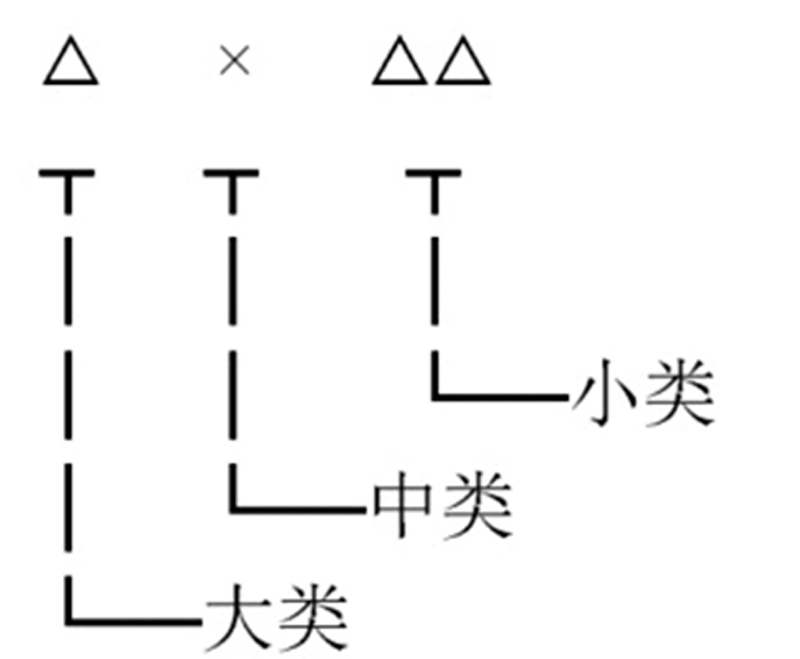
Fig.2 Structure diagram of feature class code
| 分类代码 | 要素名称 | 分类代码 | 要素名称 |
|---|---|---|---|
| 1000 | 物质要素 | 2000 | 构造要素 |
| 1100 | 坑物质 | 2100 | 环形构造 |
| 1101 | 哥白尼纪坑物质 | 2101 | 撞击坑 |
| 1102 | 爱拉托逊纪坑物质 | 2102 | 隐伏撞击坑 |
| 1103 | 晚雨海世坑物质 | 2103 | 撞击盆地 |
| 1104 | 早雨海世坑物质 | 2104 | 穹隆 |
| 1105 | 雨海纪未细分坑物质 | 2105 | 火山口 |
| 1106 | 酒海纪坑物质 | 2106 | 质量瘤 |
| 1107 | 艾肯纪坑物质 | 2200 | 线性构造 |
| 1108 | 年代未确定坑物质 | 2201 | 浅层断裂 |
| 1200 | 盆地建造 | 2202 | 推测深部断裂 |
| 1201 | 雨海纪盆地建造 | 2203 | 坑底断裂 |
| 1202 | 酒海纪盆地建造 | 2204 | 撞击断裂 |
| 1203 | 艾肯纪盆地建造 | 2205 | 撞击坑链 |
| 1300 | 月海玄武岩 | 2206 | 月溪 |
| 1400 | 非月海岩石 | 2207 | 月堑 |
| 1401 | KREEP岩套 | 2208 | 皱脊 |
| 1402 | KREEP玄武岩 | 2209 | 叶状陡坎 |
| 1403 | 镁质斜长岩套 | 2300 | 构造单元 |
| 1404 | 亚铁苏长岩套 | 2301 | 构造单元面 |
| 1405 | 亚铁斜长岩套 | 2302 | 构造单元边界 |
| 1406 | 镁质岩套 | 3000 | 其他特殊符号 |
| 1407 | 碱性岩套 | 3100 | 着陆点 |
| 1500 | 特殊岩石 | 3200 | 高程点 |
| 1501 | 纯斜长岩 | 3300 | “金钉子” |
| 1502 | 尖晶斜长岩 | 9000 | 注记 |
| 1503 | 富橄榄石岩套 | 9100 | 名称注记 |
| 1504 | 火成碎屑岩 | 9200 | 地质体代号 |
| 1505 | 硅质火山岩 |
Table 1 Feature class codes used in the lunar geological map spatial database
| 分类代码 | 要素名称 | 分类代码 | 要素名称 |
|---|---|---|---|
| 1000 | 物质要素 | 2000 | 构造要素 |
| 1100 | 坑物质 | 2100 | 环形构造 |
| 1101 | 哥白尼纪坑物质 | 2101 | 撞击坑 |
| 1102 | 爱拉托逊纪坑物质 | 2102 | 隐伏撞击坑 |
| 1103 | 晚雨海世坑物质 | 2103 | 撞击盆地 |
| 1104 | 早雨海世坑物质 | 2104 | 穹隆 |
| 1105 | 雨海纪未细分坑物质 | 2105 | 火山口 |
| 1106 | 酒海纪坑物质 | 2106 | 质量瘤 |
| 1107 | 艾肯纪坑物质 | 2200 | 线性构造 |
| 1108 | 年代未确定坑物质 | 2201 | 浅层断裂 |
| 1200 | 盆地建造 | 2202 | 推测深部断裂 |
| 1201 | 雨海纪盆地建造 | 2203 | 坑底断裂 |
| 1202 | 酒海纪盆地建造 | 2204 | 撞击断裂 |
| 1203 | 艾肯纪盆地建造 | 2205 | 撞击坑链 |
| 1300 | 月海玄武岩 | 2206 | 月溪 |
| 1400 | 非月海岩石 | 2207 | 月堑 |
| 1401 | KREEP岩套 | 2208 | 皱脊 |
| 1402 | KREEP玄武岩 | 2209 | 叶状陡坎 |
| 1403 | 镁质斜长岩套 | 2300 | 构造单元 |
| 1404 | 亚铁苏长岩套 | 2301 | 构造单元面 |
| 1405 | 亚铁斜长岩套 | 2302 | 构造单元边界 |
| 1406 | 镁质岩套 | 3000 | 其他特殊符号 |
| 1407 | 碱性岩套 | 3100 | 着陆点 |
| 1500 | 特殊岩石 | 3200 | 高程点 |
| 1501 | 纯斜长岩 | 3300 | “金钉子” |
| 1502 | 尖晶斜长岩 | 9000 | 注记 |
| 1503 | 富橄榄石岩套 | 9100 | 名称注记 |
| 1504 | 火成碎屑岩 | 9200 | 地质体代号 |
| 1505 | 硅质火山岩 |

Fig.3 Division scheme of lunar geological mapping (the base map is Chang’E-1 CCD image)
| 类别 | 图层内容 | 图层内容英文表述 | 图层命名 | 几何特征 |
|---|---|---|---|---|
| 坑物质 | 哥白尼纪坑物质 | Copemiacn Crater Materials | △△△△×_Ccm | Polygon |
| 爱拉托逊纪坑物质 | Eratothenian Crater Materials | △△△△×_Ecm | Polygon | |
| 晚雨海世坑物质 | Late Imbrian Crater Materials | △△△△×_LIcm | Polygon | |
| 早雨海世坑物质 | Early Imbrian Crater Materials | △△△△×_EIcm | Polygon | |
| 雨海纪未细分坑物质 | Undivided Imbrian Crater Materials | △△△△×_UIcm | Polygon | |
| 酒海纪坑物质 | Nectarian Crater Materials | △△△△×_Ncm | Polygon | |
| 艾肯纪坑物质 | Aitkenian Crater Materials | △△△△×_Acm | Polygon | |
| 未划分时代坑物质 | Undivided Crater Materials | △△△△×_Ucm | Polygon | |
| 盆地建造 | 雨海纪盆地建造 | Imbrian Basin Formations | △△△△×_Ibf | Polygon |
| 酒海纪盆地建造 | Nectarian Basin Formations | △△△△×_Nbf | Polygon | |
| 艾肯纪盆地建造 | Aitkenian Basin Formations | △△△△×_Abf | Polygon | |
| 月海岩石 | 月海玄武岩 | Mare Basalts | △△△△×_Mar_Bas | Polygon |
| 非月海岩石 | KREEP岩套 | KREEP Rock | △△△△×_KRE_Roc | Polygon |
| KREEP玄武岩 | KREEP Basalt | △△△△×_KRE_Bas | Point | |
| 镁质斜长岩套 | Magnesian Anorthosite | △△△△×_Mag_Ano | Polygon | |
| 亚铁苏长岩套 | Ferroan Norite | △△△△×_Fer_Nor | Polygon | |
| 亚铁斜长岩套 | Ferroan Anorthosite | △△△△×_Fer_Ano | Polygon | |
| 镁质岩套 | Mg-Suite | △△△△×_Mg_Sui | Point | |
| 碱性岩套 | Alkali Suite | △△△△×_Alk_Sui | Point | |
| 特殊岩石 | 纯斜长岩 | Pure Anorthosite | △△△△×_Pur_Ano | Point |
| 尖晶斜长岩 | Spinel Anorthosite | △△△△×_Spi_Ano | Point | |
| 富橄榄石岩套 | Olivine Outcrop | △△△△×_Oli_Out | Point | |
| 火成碎屑岩 | Pyroclastic Deposits | △△△△×_Pyr_Dep | Polygon | |
| 硅质火山岩 | Silicic Rock | △△△△×_Sil_Roc | Polygon | |
| 环状构造 | 撞击坑 | Crater | △△△△×_Cra | Line |
| 撞击盆地 | Impact Basin | △△△△×_Imp_Bas | Line | |
| 穹隆 | Dome | △△△△×_Dome | Line | |
| 火山口 | Volcano | △△△△×_Vol | Point | |
| 质量瘤 | Mascon | △△△△×_Mas | Point | |
| 线状构造 | 浅层断裂 | ShallowFault | △△△△×_Sha_Fau | Line |
| 深部断裂 | DeepFault | △△△△×_Deep_Fau | Line | |
| 坑底断裂 | Crater-Floor Fracture | △△△△×_Cra-Flo_Fra | Line | |
| 撞击断裂 | Impact Fault | △△△△×_Imp_Fau | Line | |
| 撞击坑链 | Impact Chain | △△△△×_Imp_Cha | Line | |
| 月溪 | Rille | △△△△×_Ril | Line | |
| 月堑 | Lunar Graben | △△△△×_Iun_Gra | Line | |
| 皱脊 | Wrinkle Ridge | △△△△×_Wri_Rid | Line | |
| 叶状陡坎 | Lobate Scarp | △△△△×_Lob_Sca | Line | |
| 点状符号 | 撞击坑中心点 | Crater Point | △△△△×_Cra_Poi | Point |
| 盆地中心点 | Basin Point | △△△△×_Bas_Poi | Point | |
| 着陆点 | Landing Points | △△△△×_Lan_Poi | Point | |
| 高程点 | Elevation Points | △△△△×_Ele_Poi | Point | |
| 注记 | 名称注记 | Character Annotation | △△△△×_Cha_Ann | Annotation |
| 地质体代号 | Geological Body | △△△△×_Geo_Bod | Annotation |
Table 2 Layer contents, names and geometrical characteristics
| 类别 | 图层内容 | 图层内容英文表述 | 图层命名 | 几何特征 |
|---|---|---|---|---|
| 坑物质 | 哥白尼纪坑物质 | Copemiacn Crater Materials | △△△△×_Ccm | Polygon |
| 爱拉托逊纪坑物质 | Eratothenian Crater Materials | △△△△×_Ecm | Polygon | |
| 晚雨海世坑物质 | Late Imbrian Crater Materials | △△△△×_LIcm | Polygon | |
| 早雨海世坑物质 | Early Imbrian Crater Materials | △△△△×_EIcm | Polygon | |
| 雨海纪未细分坑物质 | Undivided Imbrian Crater Materials | △△△△×_UIcm | Polygon | |
| 酒海纪坑物质 | Nectarian Crater Materials | △△△△×_Ncm | Polygon | |
| 艾肯纪坑物质 | Aitkenian Crater Materials | △△△△×_Acm | Polygon | |
| 未划分时代坑物质 | Undivided Crater Materials | △△△△×_Ucm | Polygon | |
| 盆地建造 | 雨海纪盆地建造 | Imbrian Basin Formations | △△△△×_Ibf | Polygon |
| 酒海纪盆地建造 | Nectarian Basin Formations | △△△△×_Nbf | Polygon | |
| 艾肯纪盆地建造 | Aitkenian Basin Formations | △△△△×_Abf | Polygon | |
| 月海岩石 | 月海玄武岩 | Mare Basalts | △△△△×_Mar_Bas | Polygon |
| 非月海岩石 | KREEP岩套 | KREEP Rock | △△△△×_KRE_Roc | Polygon |
| KREEP玄武岩 | KREEP Basalt | △△△△×_KRE_Bas | Point | |
| 镁质斜长岩套 | Magnesian Anorthosite | △△△△×_Mag_Ano | Polygon | |
| 亚铁苏长岩套 | Ferroan Norite | △△△△×_Fer_Nor | Polygon | |
| 亚铁斜长岩套 | Ferroan Anorthosite | △△△△×_Fer_Ano | Polygon | |
| 镁质岩套 | Mg-Suite | △△△△×_Mg_Sui | Point | |
| 碱性岩套 | Alkali Suite | △△△△×_Alk_Sui | Point | |
| 特殊岩石 | 纯斜长岩 | Pure Anorthosite | △△△△×_Pur_Ano | Point |
| 尖晶斜长岩 | Spinel Anorthosite | △△△△×_Spi_Ano | Point | |
| 富橄榄石岩套 | Olivine Outcrop | △△△△×_Oli_Out | Point | |
| 火成碎屑岩 | Pyroclastic Deposits | △△△△×_Pyr_Dep | Polygon | |
| 硅质火山岩 | Silicic Rock | △△△△×_Sil_Roc | Polygon | |
| 环状构造 | 撞击坑 | Crater | △△△△×_Cra | Line |
| 撞击盆地 | Impact Basin | △△△△×_Imp_Bas | Line | |
| 穹隆 | Dome | △△△△×_Dome | Line | |
| 火山口 | Volcano | △△△△×_Vol | Point | |
| 质量瘤 | Mascon | △△△△×_Mas | Point | |
| 线状构造 | 浅层断裂 | ShallowFault | △△△△×_Sha_Fau | Line |
| 深部断裂 | DeepFault | △△△△×_Deep_Fau | Line | |
| 坑底断裂 | Crater-Floor Fracture | △△△△×_Cra-Flo_Fra | Line | |
| 撞击断裂 | Impact Fault | △△△△×_Imp_Fau | Line | |
| 撞击坑链 | Impact Chain | △△△△×_Imp_Cha | Line | |
| 月溪 | Rille | △△△△×_Ril | Line | |
| 月堑 | Lunar Graben | △△△△×_Iun_Gra | Line | |
| 皱脊 | Wrinkle Ridge | △△△△×_Wri_Rid | Line | |
| 叶状陡坎 | Lobate Scarp | △△△△×_Lob_Sca | Line | |
| 点状符号 | 撞击坑中心点 | Crater Point | △△△△×_Cra_Poi | Point |
| 盆地中心点 | Basin Point | △△△△×_Bas_Poi | Point | |
| 着陆点 | Landing Points | △△△△×_Lan_Poi | Point | |
| 高程点 | Elevation Points | △△△△×_Ele_Poi | Point | |
| 注记 | 名称注记 | Character Annotation | △△△△×_Cha_Ann | Annotation |
| 地质体代号 | Geological Body | △△△△×_Geo_Bod | Annotation |
| 序号 | 字段名称 | 别名 | 字段类型 | 能(Y)否(N)为空 | 长度 | 小数位 | 单位 |
|---|---|---|---|---|---|---|---|
| 1 | Feature_ID | 要素标识号 | 字符型 | N | 12 | ||
| 2 | Feature_T | 要素分类代码 | 字符型 | N | 4 | ||
| 3 | C_Name | 中文名称 | 字符型 | Y | 50 | ||
| 4 | E_Name | 英文名称 | 字符型 | Y | 50 | ||
| 5 | Quadrangle | 所属图幅 | 字符型 | N | 10 | ||
| 6 | Class | 坑物质类型 | 字符型 | N | 50 | ||
| 7 | Geobody | 地质体代号 | 字符型 | N | 50 | ||
| 8 | Area | 坑物质面积 | 浮点型 | N | 50 | 4 | km2 |
| 9 | In_Peri | 内周长 | 浮点型 | Y | 20 | 4 | km |
| 10 | Out_Peri | 外周长 | 浮点型 | Y | 20 | 4 | km |
| 11 | Rou_115 | 粗糙度1 | 浮点型 | N | 20 | 4 | m-1 |
| 12 | Rou_230 | 粗糙度2 | 浮点型 | N | 20 | 4 | m-1 |
| 13 | Rou_460 | 粗糙度3 | 浮点型 | N | 20 | 4 | m-1 |
| 14 | Rou_920 | 粗糙度4 | 浮点型 | N | 20 | 4 | m-1 |
| 15 | Rou_1800 | 粗糙度5 | 浮点型 | N | 20 | 4 | m-1 |
| 16 | RA | 岩石丰度 | 浮点型 | N | 20 | 2 | % |
| 17 | ST | 月壤温度 | 浮点型 | N | 20 | 2 | K |
| 18 | F_Desc | 特征描述 | 字符型 | Y | 500 |
Table 3 Attribute table of crater materials layer (applicable to crater materials of all eras)
| 序号 | 字段名称 | 别名 | 字段类型 | 能(Y)否(N)为空 | 长度 | 小数位 | 单位 |
|---|---|---|---|---|---|---|---|
| 1 | Feature_ID | 要素标识号 | 字符型 | N | 12 | ||
| 2 | Feature_T | 要素分类代码 | 字符型 | N | 4 | ||
| 3 | C_Name | 中文名称 | 字符型 | Y | 50 | ||
| 4 | E_Name | 英文名称 | 字符型 | Y | 50 | ||
| 5 | Quadrangle | 所属图幅 | 字符型 | N | 10 | ||
| 6 | Class | 坑物质类型 | 字符型 | N | 50 | ||
| 7 | Geobody | 地质体代号 | 字符型 | N | 50 | ||
| 8 | Area | 坑物质面积 | 浮点型 | N | 50 | 4 | km2 |
| 9 | In_Peri | 内周长 | 浮点型 | Y | 20 | 4 | km |
| 10 | Out_Peri | 外周长 | 浮点型 | Y | 20 | 4 | km |
| 11 | Rou_115 | 粗糙度1 | 浮点型 | N | 20 | 4 | m-1 |
| 12 | Rou_230 | 粗糙度2 | 浮点型 | N | 20 | 4 | m-1 |
| 13 | Rou_460 | 粗糙度3 | 浮点型 | N | 20 | 4 | m-1 |
| 14 | Rou_920 | 粗糙度4 | 浮点型 | N | 20 | 4 | m-1 |
| 15 | Rou_1800 | 粗糙度5 | 浮点型 | N | 20 | 4 | m-1 |
| 16 | RA | 岩石丰度 | 浮点型 | N | 20 | 2 | % |
| 17 | ST | 月壤温度 | 浮点型 | N | 20 | 2 | K |
| 18 | F_Desc | 特征描述 | 字符型 | Y | 500 |
| 序号 | 字段名称 | 别名 | 字段类型 | 能(Y)否(N)为空 | 长度 | 小数位 | 单位 |
|---|---|---|---|---|---|---|---|
| 1 | Feature_ID | 要素标识号 | 字符型 | N | 12 | ||
| 2 | Feature_T | 要素分类代码 | 字符型 | N | 4 | ||
| 3 | Quadrangle | 所属图幅 | 字符型 | N | 10 | ||
| 4① | Class | 岩石类型 | 字符型 | N | 50 | ||
| 5 | Geobody | 地质体代号 | 字符型 | N | 50 | ||
| 6 | Area | 面积 | 浮点型 | N | 50 | 4 | km2 |
| 7② | Unit | 月海单元 | 字符型 | Y | 10 | ||
| 8③ | ModelAge1 | 模式年龄1 | 字符型 | Y | 15 | Ga | |
| 9④ | ModelAge2 | 模式年龄2 | 字符型 | Y | 15 | Ga | |
| 10⑤ | ModelAge3 | 模式年龄3 | 字符型 | Y | 15 | Ga |
Table 4 Attribute table of lunar mare basalt layer
| 序号 | 字段名称 | 别名 | 字段类型 | 能(Y)否(N)为空 | 长度 | 小数位 | 单位 |
|---|---|---|---|---|---|---|---|
| 1 | Feature_ID | 要素标识号 | 字符型 | N | 12 | ||
| 2 | Feature_T | 要素分类代码 | 字符型 | N | 4 | ||
| 3 | Quadrangle | 所属图幅 | 字符型 | N | 10 | ||
| 4① | Class | 岩石类型 | 字符型 | N | 50 | ||
| 5 | Geobody | 地质体代号 | 字符型 | N | 50 | ||
| 6 | Area | 面积 | 浮点型 | N | 50 | 4 | km2 |
| 7② | Unit | 月海单元 | 字符型 | Y | 10 | ||
| 8③ | ModelAge1 | 模式年龄1 | 字符型 | Y | 15 | Ga | |
| 9④ | ModelAge2 | 模式年龄2 | 字符型 | Y | 15 | Ga | |
| 10⑤ | ModelAge3 | 模式年龄3 | 字符型 | Y | 15 | Ga |
| 序号 | 字段名称 | 别名 | 字段类型 | 能(Y)否(N)为空 | 长度 | 小数位 | 单位 |
|---|---|---|---|---|---|---|---|
| 1 | Feature_ID | 要素标识号 | 字符型 | N | 12 | ||
| 2 | Feature_T | 要素分类代码 | 字符型 | N | 4 | ||
| 3 | C_Name | 中文名称 | 字符型 | Y | 50 | ||
| 4 | E_Name | 英文名称 | 字符型 | Y | 50 | ||
| 5 | Quadrangle | 所属图幅 | 字符型 | N | 10 | ||
| 6 | Length | 长度 | 浮点型 | N | 15 | 4 | km |
| 7 | Era | 时代 | 字符型 | Y | 15 | ||
| 8 | EndP1_Lon | 端点1经度 | 浮点型 | N | 15 | 4 | ° |
| 9 | EndP1_Lat | 端点1纬度 | 浮点型 | N | 15 | 4 | ° |
| 10 | EndP2_Lon | 端点2经度 | 浮点型 | N | 15 | 4 | ° |
| 11 | EndP2_Lat | 端点2纬度 | 浮点型 | N | 15 | 4 | ° |
| 12① | Tec_Unit | 所属构造区 | 字符型 | N | 50 | ||
| 13② | F_Desc | 特征描述 | 字符型 | Y | 500 |
Table 5 Attribute table of impact fault layer
| 序号 | 字段名称 | 别名 | 字段类型 | 能(Y)否(N)为空 | 长度 | 小数位 | 单位 |
|---|---|---|---|---|---|---|---|
| 1 | Feature_ID | 要素标识号 | 字符型 | N | 12 | ||
| 2 | Feature_T | 要素分类代码 | 字符型 | N | 4 | ||
| 3 | C_Name | 中文名称 | 字符型 | Y | 50 | ||
| 4 | E_Name | 英文名称 | 字符型 | Y | 50 | ||
| 5 | Quadrangle | 所属图幅 | 字符型 | N | 10 | ||
| 6 | Length | 长度 | 浮点型 | N | 15 | 4 | km |
| 7 | Era | 时代 | 字符型 | Y | 15 | ||
| 8 | EndP1_Lon | 端点1经度 | 浮点型 | N | 15 | 4 | ° |
| 9 | EndP1_Lat | 端点1纬度 | 浮点型 | N | 15 | 4 | ° |
| 10 | EndP2_Lon | 端点2经度 | 浮点型 | N | 15 | 4 | ° |
| 11 | EndP2_Lat | 端点2纬度 | 浮点型 | N | 15 | 4 | ° |
| 12① | Tec_Unit | 所属构造区 | 字符型 | N | 50 | ||
| 13② | F_Desc | 特征描述 | 字符型 | Y | 500 |
| 序号 | 字段名称 | 别名 | 字段类型 | 能(Y)否(N)为空 | 长度 | 小数位 | 单位 |
|---|---|---|---|---|---|---|---|
| 1 | Feature_ID | 要素标识号 | 字符型 | N | 12 | ||
| 2 | Feature_T | 要素分类代码 | 字符型 | N | 4 | ||
| 3 | C_Name | 中文名称 | 字符型 | Y | 50 | ||
| 4 | E_Name | 英文名称 | 字符型 | Y | 50 | ||
| 5 | Quadrangle | 所属图幅 | 字符型 | N | 10 | ||
| 6 | Lon | 中心经度 | 浮点型 | N | 15 | 4 | ° |
| 7 | Lat | 中心纬度 | 浮点型 | N | 15 | 4 | ° |
| 8 | Elevation | 中心高程 | 浮点型 | N | 15 | 4 | km |
Table 6 Attribute table of elevation point layer
| 序号 | 字段名称 | 别名 | 字段类型 | 能(Y)否(N)为空 | 长度 | 小数位 | 单位 |
|---|---|---|---|---|---|---|---|
| 1 | Feature_ID | 要素标识号 | 字符型 | N | 12 | ||
| 2 | Feature_T | 要素分类代码 | 字符型 | N | 4 | ||
| 3 | C_Name | 中文名称 | 字符型 | Y | 50 | ||
| 4 | E_Name | 英文名称 | 字符型 | Y | 50 | ||
| 5 | Quadrangle | 所属图幅 | 字符型 | N | 10 | ||
| 6 | Lon | 中心经度 | 浮点型 | N | 15 | 4 | ° |
| 7 | Lat | 中心纬度 | 浮点型 | N | 15 | 4 | ° |
| 8 | Elevation | 中心高程 | 浮点型 | N | 15 | 4 | km |

Fig.4 Coding structure diagram of field Feature_ID
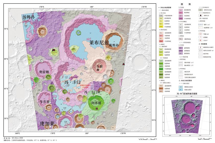
Fig. 5 Sample regional geological map of Von Karman impact crater
| 类别 | 图层内容 | 图层命名 | 几何特征 |
|---|---|---|---|
| 坑物质 | 哥白尼纪坑物质 | VonkZ_Ccm | Polygon |
| 爱拉托逊纪坑物质 | VonkZ_Ecm | Polygon | |
| 晚雨海世坑物质 | VonkZ_LIcm | Polygon | |
| 早雨海世坑物质 | VonkZ_EICm | Polygon | |
| 雨海纪未细分坑物质 | VonkZ_UIcm | Polygon | |
| 酒海纪坑物质 | VonkZ_Ncm | Polygon | |
| 艾肯纪坑物质 | VonkZ_Acm | Polygon | |
| 未划分时代坑物质 | VonkZ_Ucm | Polygon | |
| 盆地建造 | 艾肯纪盆地建造 | VonkZ_Abf | Polygon |
| 酒海纪盆地建造 | VonkZ_Nbf | Polygon | |
| 月海岩石 | 月海玄武岩 | VonkZ_Mar_Bas | Polygon |
| 非月海岩石 | 亚铁苏长岩套 | VonkZ_Fer_Nor | Polygon |
| 特殊岩石 | 纯斜长岩 | VonkZ_Pur_Ano | Point |
| 环形构造 | 撞击坑 | VonkZ_Cra | Line |
| 隐伏撞击坑 | VonkZ_Bur_Cra | Line | |
| 撞击盆地 | VonkZ_Imp_Bas | Line | |
| 穹隆 | VonkZ_Dome | Line | |
| 火山口 | VonkZ_Vol_Ven | Point | |
| 质量瘤 | VonkZ_Mas | Point | |
| 线性构造 | 浅层断裂 | VonkZ_Sha_Fau | Line |
| 撞击断裂 | VonkZ_Imp_Fau | Line | |
| 撞击坑链 | VonkZ_Imp_Cha | Line | |
| 皱脊 | VonkZ_Wri_Rid | Line | |
| 其他特殊 符号 | 着陆点 | VonkZ_Lan_Poi | Point |
| 高程点 | VonkZ_Ele_Pt | Point | |
| 注记 | 名称注记 | VonkZ_Cha_Ann | Annotation |
| 地质体代号 | VonkZ_Geo_Bod | Annotation |
Table 7 Organization and management modes of geological map spatial feature classes for Von Karman impact crater and adjacent areas
| 类别 | 图层内容 | 图层命名 | 几何特征 |
|---|---|---|---|
| 坑物质 | 哥白尼纪坑物质 | VonkZ_Ccm | Polygon |
| 爱拉托逊纪坑物质 | VonkZ_Ecm | Polygon | |
| 晚雨海世坑物质 | VonkZ_LIcm | Polygon | |
| 早雨海世坑物质 | VonkZ_EICm | Polygon | |
| 雨海纪未细分坑物质 | VonkZ_UIcm | Polygon | |
| 酒海纪坑物质 | VonkZ_Ncm | Polygon | |
| 艾肯纪坑物质 | VonkZ_Acm | Polygon | |
| 未划分时代坑物质 | VonkZ_Ucm | Polygon | |
| 盆地建造 | 艾肯纪盆地建造 | VonkZ_Abf | Polygon |
| 酒海纪盆地建造 | VonkZ_Nbf | Polygon | |
| 月海岩石 | 月海玄武岩 | VonkZ_Mar_Bas | Polygon |
| 非月海岩石 | 亚铁苏长岩套 | VonkZ_Fer_Nor | Polygon |
| 特殊岩石 | 纯斜长岩 | VonkZ_Pur_Ano | Point |
| 环形构造 | 撞击坑 | VonkZ_Cra | Line |
| 隐伏撞击坑 | VonkZ_Bur_Cra | Line | |
| 撞击盆地 | VonkZ_Imp_Bas | Line | |
| 穹隆 | VonkZ_Dome | Line | |
| 火山口 | VonkZ_Vol_Ven | Point | |
| 质量瘤 | VonkZ_Mas | Point | |
| 线性构造 | 浅层断裂 | VonkZ_Sha_Fau | Line |
| 撞击断裂 | VonkZ_Imp_Fau | Line | |
| 撞击坑链 | VonkZ_Imp_Cha | Line | |
| 皱脊 | VonkZ_Wri_Rid | Line | |
| 其他特殊 符号 | 着陆点 | VonkZ_Lan_Poi | Point |
| 高程点 | VonkZ_Ele_Pt | Point | |
| 注记 | 名称注记 | VonkZ_Cha_Ann | Annotation |
| 地质体代号 | VonkZ_Geo_Bod | Annotation |
| [1] |
范本贤, 张庆合, 剧远景, 等. 中国区域地质志空间数据库结构设计[J]. 地球信息科学学报, 2011, 13(6):720-726.
DOI |
| [2] | 李廷栋. 国际地质编图现状及发展趋势[J]. 中国地质, 2007, 34(2):206-211. |
| [3] |
李廷栋, 丁伟翠, 郑宁, 等. 博览群图提升地质制图的科学技术水平[J]. 地球信息科学学报, 2011, 13(6):711-719, 726.
DOI |
| [4] | 凌宗成, 张江, 刘建忠, 等. 嫦娥一号干涉成像光谱仪数据再校正与全月铁钛元素反演[J]. 岩石学报, 2016, 32(1):87-98. |
| [5] | 孟治国, 陈圣波, EDWARD MATTHEW O J, 等. 基于嫦娥一号卫星微波辐射计数据的月球Cabeus撞击坑水冰含量研究[J]. 中国科学: 物理学力学天文学, 2010, 40(11):1363-1369. |
| [6] | 丁孝忠, 韩坤英, 韩同林, 等. 月球虹湾幅(LQ-4)地质图的编制[J]. 地学前缘, 2012, 19(6):15-27. |
| [7] | 朱永超, 郑永春, 邹永廖. 月球表面“冷点”和“热区”研究: 嫦娥二号微波亮温数据分析[J]. 矿物学报, 2016, 36(2):231-240. |
| [8] | 邸凯昌, 刘斌, 刘召芹, 等. 月球遥感制图回顾与展望[J]. 遥感学报, 2016, 20(5):1230-1242. |
| [9] | 籍进柱, 刘建忠, 郭弟均, 等. 云海撞击盆地的恢复及其地质演化研究[J]. 岩石学报, 2016, 32(1):127-134. |
| [10] | 丁孝忠, 王梁, 郭弟均, 等. 月球哥白尼纪地层特征与地质演化研究[J]. 岩石学报, 2016, 32(1):10-18. |
| [11] | 刘建忠, 籍进柱, 郭弟均, 等. 月球云海地区1: 2 500 000地质图编研进展[C]// 中国矿物岩石地球化学学会第九次全国会员代表大会暨第16届学术年会论文集. 西安, 2017: 1145-1146. |
| [12] | 凌宗成, 刘建忠, 张江, 等. 基于“嫦娥一号”干涉成像光谱仪数据的月球岩石类型填图: 以月球雨海—冷海地区(LQ-4)为例[J]. 地学前缘, 2014, 21(6):107-120. |
| [13] |
CHEN J, LING Z, LI B, et al. Abundance and distribution of radioelements in lunar terranes: results of Chang’E-1 gamma ray spectrometer data[J]. Advances in Space Research, 2016, 57:919-927.
DOI URL |
| [14] | 张江, 凌宗成, 李勃, 等. 月球Reiner Gamma漩涡地区物质的光度行为及分类[J]. 岩石学报, 2016, 32(1):113-118. |
| [15] | 陈剑, 凌宗成, 李勃, 等. 嫦娥二号γ谱数据反演月表Fe元素分布[J]. 中国科学: 物理学力学天文学, 2016, 46(2):59-66. |
| [16] | 王庆龙, 刘建忠, 郭弟均, 等. 月球雨海盆地多环结构的厘定及其深部构造研究[J]. 地学前缘, 2018, 25(1):297-313. |
| [17] | 刘建忠, 郭弟均, 籍进柱, 等. 月球的构造格架及其演化差异[J]. 深空探测学报, 2015, 2(1):75-79. |
| [18] | 王杰, 曾佐勋, 岳宗玉, 等. 月球主要构造特征: 嫦娥一号月球影像初步研究[J]. 空间科学学报, 2011, 31(4):482-491. |
| [19] | 陆天启, 陈圣波, 朱凯. 基于GRAIL重力数据的月球深部断裂识别和空间分布研究[J]. 地球物理学报, 2019, 62(8):2835-2844. |
| [20] | 罗林, 刘建忠, 张莉, 等. 月球线性构造分类体系研究[J]. 岩石学报, 2017, 33(10):3285-3301. |
| [21] | 中华人民共和国国家质量监督检验检疫总局. 信息分类和编码的基本原则与方法: GB/T 7027—2002, 北京: 中国标准出版社, 2002. |
| [22] | 中华人民共和国国家质量监督检验检疫总局, 中国国家标准化管理委员会. 基础地理信息要素分类与代码: GB/T 13923—2006[S]. 北京: 中国标准出版社, 2006. |
| [1] | LI Bin CHENG Chang-Jing. Application of spatial database in quantitative study of lithopalaeogeography—A case study of a Middle Ordovician sequence interval in Ordos Basin. [J]. Earth Science Frontiers, 2009, 16(5): 251-263. |
| Viewed | ||||||
|
Full text |
|
|||||
|
Abstract |
|
|||||