地学前缘 ›› 2025, Vol. 32 ›› Issue (2): 346-356.DOI: 10.13745/j.esf.sf.2023.9.29
曹力夫1( ), 王海燕1,2,*(), 李文辉1,2, 侯贺晟2,3, 王光文1, 庞永香4
收稿日期:2023-09-04
修回日期:2024-06-17
出版日期:2025-03-25
发布日期:2025-03-25
通信作者:
*王海燕(1975—),女,研究员,主要从事深地震反射与深部构造研究工作。E-mail:hyanwhy@126.com
作者简介:曹力夫(1999—),男,硕士研究生,主要从事宽角反射与背景噪声反演研究工作。E-mail:737358386@qq.com
基金资助:
CAO Lifu1(), WANG Haiyan1,2,*(), LI Wenhui1,2, HOU Hesheng2,3, WANG Guangwen1, PANG Yongxiang4
Received:2023-09-04
Revised:2024-06-17
Online:2025-03-25
Published:2025-03-25
摘要:
兴蒙造山带是由众多微陆块、岛弧、增生楔和蛇绿岩(洋壳残片)等构成,经历了复杂的构造演化历史,记录了古亚洲洋俯冲、西伯利亚和华北板块最终拼合等重要信息,其演化一直是国内外地学界研究的热点。研究兴蒙造山带及邻区各地质体之间的联系对其构造演化有着重要意义,获取精细的上地壳结构成为厘定兴蒙造山带不同块体之间接触关系和揭示中新生代构造演化过程的关键。本文对一条南北向跨越松辽盆地、兴蒙造山带和二连盆地总长为503 km的宽角反射和折射地震剖面数据进行了初至波层析成像研究。本研究使用有限差分算法对16个大炮数据693个初至走时拾取数据进行计算,采用变网格尺度和平滑参数的反演策略,经40次迭代反演,将RMS降至0.103 s,获得上地壳(7 km以上)精细速度结构。成像结果精细刻画了研究区地下的速度结构:北部二连盆地存在低速特征,是一个南深北浅的断陷盆地,最深处可达5.1 km,其发育主要由两侧倾向相背的正断层控制;中部兴蒙造山带(嫩江断裂与贺根山缝合带之间)上地壳呈高速特征,横向变化剧烈,存在3个山间盆地,因其多为中新生代沉积少有第四系沉积,导致其沉积层速度较造山带两侧盆地高;南部松辽盆地为典型箕状断陷盆地,受后期NWW-SEE向水平挤压引起的正断层逆向运动致使结晶基底顶界面与沉积层褶皱变形基本一致,沿测线盆地最深处可达5.5 km。基于速度异常厘定出研究区断裂带的位置和上地壳展布形态。多数断裂、断层浅处为大角度陡立状,在向深部延展过程中倾角逐渐减小,演变为铲式。
中图分类号:
曹力夫, 王海燕, 李文辉, 侯贺晟, 王光文, 庞永香. 折射Pg波层析成像揭示兴蒙造山带及其邻区上地壳结构[J]. 地学前缘, 2025, 32(2): 346-356.
CAO Lifu, WANG Haiyan, LI Wenhui, HOU Hesheng, WANG Guangwen, PANG Yongxiang. Refraction Pg tomographic imaging reveals the upper crustal structure of the Xing-Meng Orogenic Belt and its adjacent areas[J]. Earth Science Frontiers, 2025, 32(2): 346-356.

图1 奈曼旗南—东乌旗北宽角反射和折射剖面(图中位置信息据文献[55],构造信息据文献[1],盆地边界信息据文献[39,56]) a—研究区位置;b—宽角反射地震剖面位置。
Fig.1 Wide-angle reflection and refraction profile from south Naiman Banner to north Dongwu Banner. Modified from [1,39,55-56]. a—Location of the study area; b—the location of wide-angle reflection seismic profile.
| 炮点编号 | 类型 | 药量/kg | 经度/(°) | 纬度/(°) | 高程/m |
|---|---|---|---|---|---|
| A1 | 超级大炮 | 2 000 | 121.079 5 | 42.879 45 | 344.8 |
| A2 | 超级大炮 | 2 000 | 120.468 8 | 43.410 83 | 317.8 |
| A3 | 超级大炮 | 2 000 | 119.896 8 | 43.804 93 | 480.6 |
| A4 | 超级大炮 | 2 000 | 119.287 5 | 44.358 15 | 838.5 |
| A5 | 超级大炮 | 2 000 | 118.728 | 44.765 07 | 1 050.4 |
| A6 | 超级大炮 | 2 000 | 118.137 2 | 45.285 52 | 870.843 |
| A7 | 超级大炮 | 2 000 | 117.299 1 | 46.072 28 | 1 003.145 |
| B1 | 大炮 | 480 | 119.642 4 | 44.067 19 | 825.7 |
| B2 | 大炮 | 480 | 119.430 5 | 44.234 45 | 802.0 |
| B3 | 大炮 | 480 | 119.239 1 | 44.384 66 | 854.3 |
| B4 | 大炮 | 480 | 119.046 4 | 44.534 09 | 1 010.0 |
| B5 | 大炮 | 480 | 118.354 3 | 45.021 04 | 987.641 2 |
| B6 | 大炮 | 480 | 118.148 | 45.249 28 | 873.825 4 |
| B7 | 大炮 | 480 | 118.022 4 | 45.380 95 | 838.371 2 |
| B8 | 大炮 | 480 | 117.822 3 | 45.573 06 | 830.414 3 |
| B9 | 大炮 | 480 | 117.625 3 | 45.773 42 | 1 002.713 |
表1 接收炮点参数
Table 1 Reception of seismic source parameters
| 炮点编号 | 类型 | 药量/kg | 经度/(°) | 纬度/(°) | 高程/m |
|---|---|---|---|---|---|
| A1 | 超级大炮 | 2 000 | 121.079 5 | 42.879 45 | 344.8 |
| A2 | 超级大炮 | 2 000 | 120.468 8 | 43.410 83 | 317.8 |
| A3 | 超级大炮 | 2 000 | 119.896 8 | 43.804 93 | 480.6 |
| A4 | 超级大炮 | 2 000 | 119.287 5 | 44.358 15 | 838.5 |
| A5 | 超级大炮 | 2 000 | 118.728 | 44.765 07 | 1 050.4 |
| A6 | 超级大炮 | 2 000 | 118.137 2 | 45.285 52 | 870.843 |
| A7 | 超级大炮 | 2 000 | 117.299 1 | 46.072 28 | 1 003.145 |
| B1 | 大炮 | 480 | 119.642 4 | 44.067 19 | 825.7 |
| B2 | 大炮 | 480 | 119.430 5 | 44.234 45 | 802.0 |
| B3 | 大炮 | 480 | 119.239 1 | 44.384 66 | 854.3 |
| B4 | 大炮 | 480 | 119.046 4 | 44.534 09 | 1 010.0 |
| B5 | 大炮 | 480 | 118.354 3 | 45.021 04 | 987.641 2 |
| B6 | 大炮 | 480 | 118.148 | 45.249 28 | 873.825 4 |
| B7 | 大炮 | 480 | 118.022 4 | 45.380 95 | 838.371 2 |
| B8 | 大炮 | 480 | 117.822 3 | 45.573 06 | 830.414 3 |
| B9 | 大炮 | 480 | 117.625 3 | 45.773 42 | 1 002.713 |

图2 A1单炮的地震记录及其震相走时拾取
Fig.2 The seismic record of A1 single shot and its seismic phase travel time picking

图3 A2炮地震记录截面图(短线为拾取的Pg震相)
Fig.3 A2 shot seismic record cross section (short line is picked Pg seismic phase)

图4 A5炮地震记录截面图(短线为拾取的Pg震相)
Fig.4 A5 shot seismic record cross section(short line is picked Pg seismic phase)

图5 B7炮地震记录截面图(短线为拾取的Pg震相)
Fig.5 B7 shot seismic record cross section (short line is picked Pg seismic phase)
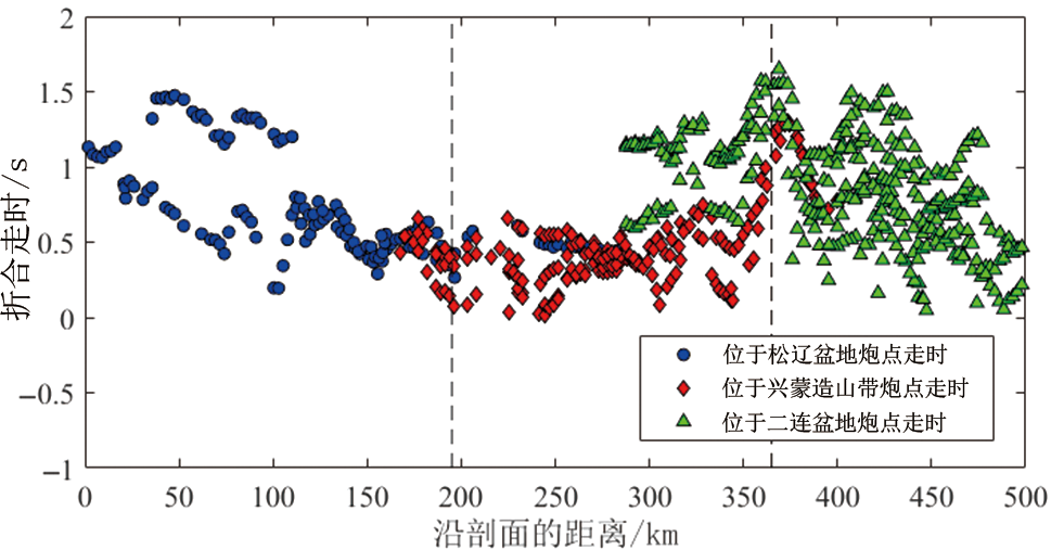
图6 Pg波走时数据沿剖面分布特征(折合速度 6.0 km/s)
Fig.6 The distribution characteristics of Pg wave travel time data along the profile (reduced velocity at 6.0 km/s)
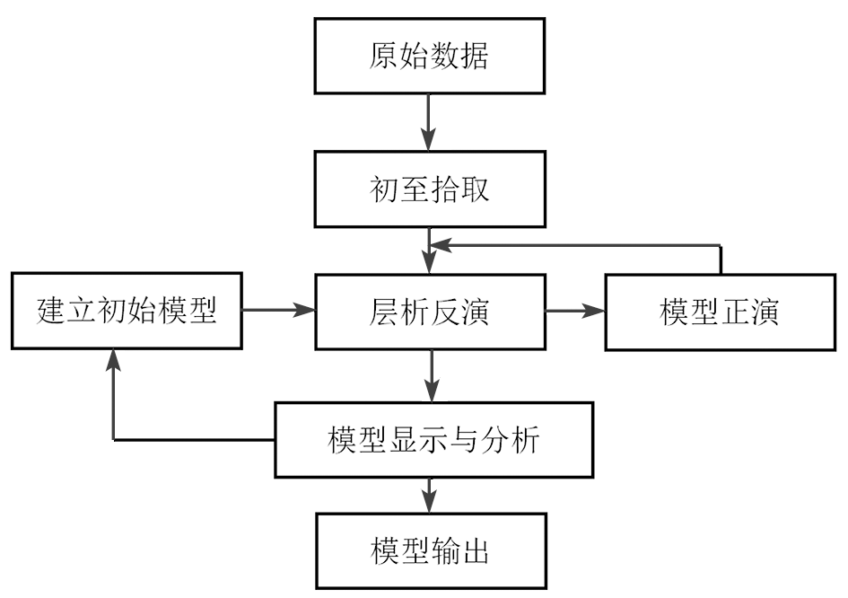
图7 正反演计算流程(引自文献[57-58])
Fig.7 Forward and inversion calculation process. Adapted from [57-58].
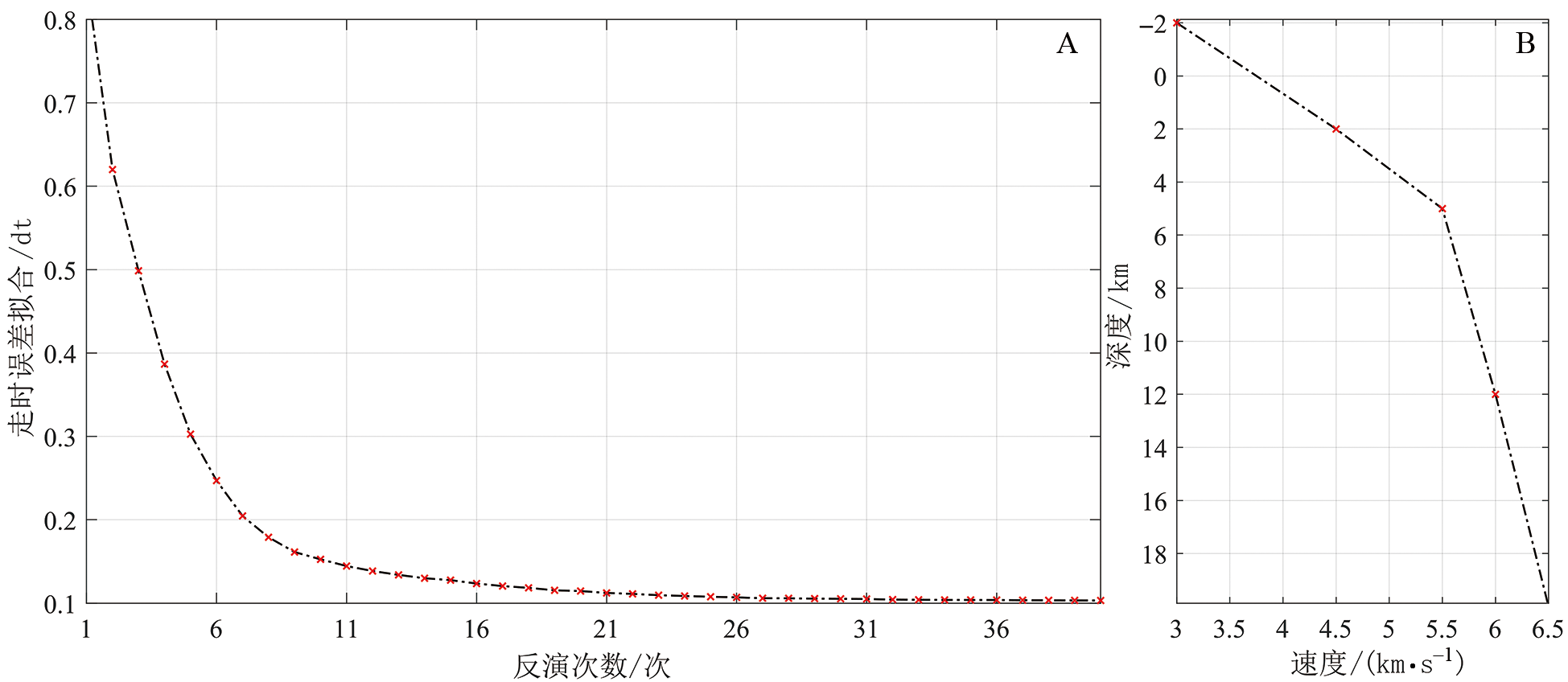
图8 层析成像迭代反演收敛曲线(A)和一维初始速度模型(B)(据文献[9])
Fig.8 Convergent curve of iterative inversions (A) and 1D initial velocity model (B). Adapted from [9].

图9 上地壳初至层析成像结果 图中:虚线—推测的断层,红色—新生代断层,蓝色—晚古生代断裂。SCS—西拉木伦缝合带;F1—嫩江断裂;F2—大兴安岭主断裂;F3—达清牧场南断裂;HHS—贺根山缝合带;F4—贺根山断裂带。
Fig.9 Upper crustal velocity model derived from first arrival tomography. The dotted line is the presumed fault, red represents the Cenozoic normal fault, blue represents the late Paleozoic fault, and the arrow represents the direction of movement of the hanging wall of the fault. SCS—Xar Moron suture zone; F1—Nenjiang fault; F2—Daxing’anling main fault; F3—Daqing ranch south fault; HHS—Hegenshan suture zone; F4—Hegenshan fault zone.

图10 层析成像网格射线密度
Fig.10 Number of rays in tomography cells
| [1] | 李锦轶, 刘建峰, 曲军峰, 等. 中国东北地区主要地质特征和地壳构造格架[J]. 岩石学报, 2019, 35(10): 2989-3016. |
| [2] | 徐备, 王志伟, 张立杨, 等. 兴蒙陆内造山带[J]. 岩石学报, 2018, 34(10): 2819-2844. |
| [3] | 许文良, 孙晨阳, 唐杰, 等. 兴蒙造山带的基底属性与构造演化过程[J]. 地球科学, 2019, 44(5): 1620-1646. |
| [4] | 洪大卫, 王式光, 谢锡林, 等. 试析地幔来源物质成矿域: 以中亚造山带为例[J]. 矿床地质, 2003, 22(1): 41-55. |
| [5] | 侯贺晟, 高锐, 李秋生, 等. 深地震反射剖面揭示的兴蒙造山带地壳精细结构的初步结果[C]// 中国地球物理学会第二十七届年会论文集. 北京: 中国地质科学院地质研究所, 2011. |
| [6] | 谭晓淼, 高锐, 王海燕, 等. 中亚造山带东段深地震反射剖面大炮揭露下地壳与Moho结构: 数据处理与初步解释[J]. 吉林大学学报(地球科学版), 2021, 51(3): 898-908. |
| [7] | 谢樊, 王海燕, 侯贺晟, 等. 中亚造山带东段浅表构造速度结构: 深地震反射剖面初至波层析成像的揭露[J]. 吉林大学学报(地球科学版), 2021, 51(2): 584-596. |
| [8] | 李英康, 高锐, 姚聿涛, 等. 大兴安岭造山带及两侧盆地的地壳速度结构[J]. 地球物理学进展, 2014, 29(1): 73-83. |
| [9] | 王海燕, 李英康, 张晨光, 等. 兴蒙造山带及邻区地壳速度结构特征[J]. 地球物理学报, 2022, 65(5): 1675-1687. |
| [10] | 熊小松, 高锐, 张兴洲, 等. 深地震探测揭示的华北及东北地区莫霍面深度[J]. 地球学报, 2011, 32(1): 46-56. |
| [11] |
龚辰, 李秋生, 叶卓, 等. 远震P波接收函数揭示的张家口(怀来)—中蒙边境(巴音温多尔)剖面地壳厚度与泊松比[J]. 地球物理学报, 2016, 59(3): 897-911.
DOI |
| [12] |
何静, 吴庆举, 张瑞青, 等. 利用接收函数研究兴蒙造山带阿巴嘎地区的地壳结构[J]. 地球物理学报, 2018, 61(9): 3676-3688.
DOI |
| [13] | 姜磊. 华北克拉通与兴蒙造山带地区地壳结构研究[D]. 北京: 中国地震局地球物理研究所, 2021. |
| [14] | 危自根, 陈凌, 杨小林. 辽东台隆、燕山带和兴蒙造山带台站下方地壳厚度和平均波速比(vP/vS)的横向变化及其构造意义[J]. 地球物理学报, 2011, 54(11): 2799-2808. |
| [15] | 涂广红, 江为为, 朱东英, 等. 中国东北地区剩余重磁异常特征与地质构造及成矿带的关系[J]. 地球物理学进展, 2006, 21(3): 746-755. |
| [16] | 王学刚, 曾昭发, 孙晓东, 等. 兴蒙造山带区域矿产空间分布与重磁异常特征关系研究[J]. 世界地质, 2017, 36(4): 1209-1218. |
| [17] | 张凤旭, 张兴洲, 张凤琴, 等. 中国东北地区重力场研究: 利用改进的三方向小子域滤波划分主构造线及大地构造单元[J]. 地球物理学报, 2010, 53(6): 1475-1485. |
| [18] |
张凯文, 陈棋福, 陈赟. 接收函数揭示的兴蒙造山带西南部的地壳结构特征[J]. 地球物理学报, 2020, 63(4): 1484-1504.
DOI |
| [19] |
韩江涛, 康建强, 刘财, 等. 中亚造山带东段软流圈分布特征: 基于长周期大地电磁探测的结果[J]. 地球物理学报, 2019, 62(3): 1148-1158.
DOI |
| [20] | 梁宏达. 大陆岩石圈电性结构研究:以大兴安岭、华北北缘、秦岭为例[D]. 北京: 中国地质科学院, 2015. |
| [21] | 慕倩, 韩江涛, 刘立家, 等. 切穿兴蒙造山带的深断面: 岩石圈电性结构及改造模式[J]. 地球物理学报, 2023, 66(4): 1603-1617. |
| [22] | KRÖNER A, KOVACH V, BELOUSOVA E, et al. Reassessment of continental growth during the accretionary history of the Central Asian Orogenic Belt[J]. Gondwana Research, 2014, 25(1): 103-125. |
| [23] | ŞENGÖR A M C, NATAL’IN B A, BURTMAN V S. Evolution of the Altaid tectonic collage and Palaeozoic crustal growth in Eurasia[J]. Nature, 1993, 364(6435): 299-307. |
| [24] | WINDLEY B F, ALEXEIEV D, XIAO W J, et al. Tectonic models for accretion of the Central Asian Orogenic Belt[J]. Journal of the Geological Society, 2007, 164(1): 31-47. |
| [25] | MENG F C, AI Y S, XU T, et al. Lithospheric structure beneath the boundary region of North China Craton and Xing Meng Orogenic Belt from S-receiver function analysis[J]. Tectonophysics, 2021, 818: 229067. |
| [26] | GOU J, SUN D Y, MAO A Q, et al. Geochronology and geochemistry of Ordovician plutons in the erguna block (NE China): further insights into the tectonic evolution of the Xing’an-Mongolia Orogenic Belt[J]. International Geology Review, 2019, 61(8): 936-955. |
| [27] | WANG R L, ZENG Q D, ZHANG Z C, et al. Extensive mineralization in the eastern segment of the Xingmeng Orogenic Belt, NE China: a regional view[J]. Ore Geology Reviews, 2021, 135: 104204. |
| [28] | 葛文春, 吴福元, 周长勇, 等. 兴蒙造山带东段斑岩型Cu, Mo矿床成矿时代及其地球动力学意义[J]. 科学通报, 2007, 52(20): 2407-2417. |
| [29] | 李可, 张志诚, 冯志硕, 等. 兴蒙造山带中段北部晚古生代两期岩浆活动及其构造意义[J]. 地质学报, 2015, 89(2): 272-288. |
| [30] | 李双林, 欧阳自远. 兴蒙造山带及邻区的构造格局与构造演化[J]. 海洋地质与第四纪地质, 1998, 18(3): 46-55. |
| [31] | 邵济安, 臧绍先, 牟保磊, 等. 造山带的伸展构造与软流圈隆起: 以兴蒙造山带为例[J]. 科学通报, 1994, 39(6): 533-537. |
| [32] | 徐备, 赵盼, 鲍庆中, 等. 兴蒙造山带前中生代构造单元划分初探[J]. 岩石学报, 2014, 30(7): 1841-1857. |
| [33] | 张焱杰, 徐备, 田英杰, 等. 兴蒙造山带晚古生代伸展过程: 来自二连浩特东北部石炭—二叠系沉积地层的证据[J]. 岩石学报, 2018, 34(10): 3083-3100. |
| [34] | DOBRETSOV N L, BERZIN N A, BUSLOV M M. Opening andtectonic evolution of the Paleo-Asian Ocean[J]. International Geology Review, 1995, 37(4): 335-360. |
| [35] | SAFONOVA I Y, SANTOSH M. Accretionary complexes in the Asia-Pacific Region: tracing archives of ocean plate stratigraphy and tracking mantle plumes[J]. Gondwana Research, 2014, 25(1): 126-158. |
| [36] | SENGOR A. Paleotectonics of Asia: fragments of a synthesis[J]. World and Regional Geology, 1996, 1(8): 486-640. |
| [37] | 程银行. 松辽盆地晚白垩世以来沉积充填及构造演化研究[D]. 北京: 中国地质大学(北京), 2019. |
| [38] | 胡望水, 吕炳全, 张文军, 等. 松辽盆地构造演化及成盆动力学探讨[J]. 地质科学, 2005, 40(1): 16-31. |
| [39] | 葛荣峰, 张庆龙, 王良书, 等. 松辽盆地构造演化与中国东部构造体制转换[J]. 地质论评, 2010, 56(2): 180-195. |
| [40] | 李娟, 舒良树. 松辽盆地中、新生代构造特征及其演化[J]. 南京大学学报(自然科学), 2002, 38(4): 525-531. |
| [41] | 刘招君, 柳蓉. 中国油页岩特征及开发利用前景分析[J]. 地学前缘, 2005, 12(3): 315-323. |
| [42] | ZHAO W J, ZHU H, DING Q H. Large scale magnetotelluric sounding at the periphery of the Songliao Basin, NE China[J]. ASEG Extended Abstracts, 2016, 2016(1): 1-8. |
| [43] | 郭巍, 刘招君, 董惠民, 等. 松辽盆地层序地层特征及油气聚集规律[J]. 吉林大学学报(地球科学版), 2004, 34(2): 216-221. |
| [44] | 舒良树, 慕玉福, 王伯长. 松辽盆地含油气地层及其构造特征[J]. 地层学杂志, 2003, 27(4): 340-347. |
| [45] | 王璞珺, 迟元林, 刘万洙, 等. 松辽盆地火山岩相: 类型、特征和储层意义[J]. 吉林大学学报(地球科学版), 2003, 33(4): 449-456. |
| [46] | 王璞珺, 吴河勇, 庞颜明, 等. 松辽盆地火山岩相: 相序、相模式与储层物性的定量关系[J]. 吉林大学学报(地球科学版), 2006, 36(5): 805-812. |
| [47] | LI Y N, WANG S, YE Z R, et al. The sedimentary filling differences of subsags and their impacts on oil shale and coal accumulation in a rift lacustrine sag: a case study from the lower Cretaceous in the Zhangqiang Sag, southern Songliao Basin, Northeast China[J]. Marine and Petroleum Geology, 2023, 155: 106354. |
| [48] |
贾承造, 邹才能, 李建忠, 等. 中国致密油评价标准、 主要类型、 基本特征及资源前景[J]. 石油学报, 2012, 33(3): 343-350.
DOI |
| [49] | 王璞珺, 杜小弟, 王俊, 等. 松辽盆地白垩纪年代地层研究及地层时代划分[J]. 地质学报, 1995, 69(4): 372-381. |
| [50] | 张兴洲, 周建波, 迟效国, 等. 东北地区晚古生代构造-沉积特征与油气资源[J]. 吉林大学学报(地球科学版), 2008, 38(5): 719-725. |
| [51] | 任建业, 李思田, 焦贵浩. 二连断陷盆地群伸展构造系统及其发育的深部背景[J]. 地球科学: 中国地质大学学报, 1998, 23(6): 24-29. |
| [52] | 刘陟娜, 乔鹏, 阎学成, 等. 二连盆地哈达图铀矿床铀赋存特征研究及成因探讨[J]. 东华理工大学学报(自然科学版), 2022, 45(4): 372-381. |
| [53] | 伍显红, 许第桥, 李茂. 宽频大地电磁法在二连盆地铀矿资源评价中的试验应用[J]. 物探与化探, 2022(4): 830-837. |
| [54] | 肖安成, 杨树锋, 陈汉林. 二连盆地形成的地球动力学背景[J]. 石油与天然气地质, 2001, 22(2): 137-140, 145. |
| [55] | 周建波, 石爱国, 景妍. 东北地块群: 构造演化与古大陆重建[J]. 吉林大学学报(地球科学版), 2016, 46(4): 1042-1055. |
| [56] | 张凤旭, 姚欢, 张兴洲, 等. 二连盆地“三明治” 电性结构特征及其对古生界的研究意义[J]. 地球物理学报, 2012, 55(9): 3134-3143. |
| [57] | HOLE J A. Nonlinear high-resolution three-dimensional seismic travel time tomography[J]. Journal of Geophysical Research: Solid Earth, 1992, 97(B5): 6553-6562. |
| [58] | VIDALE J E. Finite-difference calculation of traveltimes in three dimensions[J]. Geophysics, 1990, 55(5): 521-526. |
| [59] |
李文辉, 王海燕, 高锐, 等. 秦岭造山带及邻区上地壳精细速度结构研究[J]. 地学前缘, 2022, 29(2): 198-209.
DOI |
| [60] | CHRISTENSEN N I, MOONEY W D. Seismic velocity structure and composition of the continental crust: a globalview[J]. Journal of Geophysical Research: Solid Earth, 1995, 100(B6): 9761-9788. |
| [61] |
郭文斌, 嘉世旭, 段永红, 等. 青藏高原东北缘基底结构研究: 玛多—共和—雅布赖剖面上地壳地震折射探测[J]. 地球物理学报, 2016, 59(10): 3627-3636.
DOI |
| [62] | 王夫运, 段永红, 杨卓欣, 等. 川西盐源—马边地震带上地壳速度结构和活动断裂研究: 高分辨率地震折射实验结果[J]. 中国科学D辑: 地球科学, 2008, 38(5): 611-621. |
| [63] |
徐涛, 张明辉, 田小波, 等. 丽江—清镇剖面上地壳速度结构及其与鲁甸Ms6.5级地震孕震环境的关系[J]. 地球物理学报, 2014, 57(9): 3069-3079.
DOI |
| [64] | 张欲清. 内蒙古克什克腾—林西地区晚古生代—中生代构造变形与西拉木伦缝合带构造演化[D]. 北京: 中国地质大学(北京), 2016. |
| [65] | 葛荣峰. 松辽盆地中部断陷期构造演化与地壳伸展[D]. 南京: 南京大学, 2011. |
| [66] | 崔永谦, 刘喜恒, 孙朝辉, 等. 内蒙古二连盆地深层地球物理特征和上古生界的地质结构[J]. 地质通报, 2011, 30(增刊1): 235-242. |
| [67] | 郭阳阳. 二连盆地乌尼特坳陷重力场及构造特征研究[D]. 西安: 西安石油大学, 2019. |
| [68] | 祝玉衡, 张文朝. 二连盆地层序地层样式及油气意义[J]. 石油勘探与开发, 1999, 26(4): 49-53, 5. |
| [1] | 胡刚, 邵磊, 郭磊. 跨安宁河断裂带井间地震层析成像研究[J]. 地学前缘, 2025, 32(4): 444-452. |
| [2] | 王斌, 孙东生, 李阿伟, 杨跃辉, 陈群策. 松辽盆地深部基底地应力状态:来自松科2井地应力实测数据的证据[J]. 地学前缘, 2024, 31(2): 377-390. |
| [3] | 王成善, 高远, 王璞珺, 吴怀春, 吕庆田, 朱永宜, 万晓樵, 邹长春, 黄永建, 高有峰, 席党鹏, 王稳石, 贺怀宇, 冯子辉, 杨光, 邓成龙, 张来明, 王天天, 胡滨, 崔立伟, 彭诚, 余恩晓, 黄何, 杨柳, 毋正轩. 松辽盆地国际大陆科学钻探:白垩纪恐龙时代陆相地质记录[J]. 地学前缘, 2024, 31(1): 412-430. |
| [4] | 吴怀春, 李山, 王成善, 褚润健, 王璞珺, 高远, 万晓樵, 贺怀宇, 邓成龙, 杨光, 黄永建, 高有峰, 席党鹏, 王天天, 房强, 杨天水, 张世红. 松辽盆地白垩纪综合年代地层格架[J]. 地学前缘, 2024, 31(1): 431-445. |
| [5] | 项鑫, 黄传炎, 曹兰柱, 曹强, 江涛, 张宇飞, 宋宇, 徐婕. 二连盆地洼槽区非常规油气富集模式及勘探潜力[J]. 地学前缘, 2023, 30(6): 462-472. |
| [6] | 李瑞磊, 杨立英, 朱建峰, 刘玉虎, 徐文, 李忠博, 樊薛沛, 冷庆磊, 张婷婷. 松辽盆地南部断陷层火山岩储层特征及油气成藏主控因素[J]. 地学前缘, 2023, 30(4): 100-111. |
| [7] | 刘晓宇, 杨文采, 陈召曦, 瞿辰, 于常青. 青藏高原东部地块的属性与演化[J]. 地学前缘, 2023, 30(3): 233-241. |
| [8] | 高航, 王璞珺, 高有峰, 万晓樵, 杨光, 户景松, 吴怀春. 松辽盆地南部上、下白垩统界线研究:以松辽盆地国际大陆科学钻探松科3井为例[J]. 地学前缘, 2023, 30(3): 425-440. |
| [9] | 郭知鑫, 杨永太, 任祎, 王正庆, 冯志刚, 陈亮, 唐振平. 二连盆地吉尔嘎朗图凹陷南部基底花岗岩形成演化及其大地构造背景研究[J]. 地学前缘, 2023, 30(2): 259-271. |
| [10] | 高福建, 邹志辉, 王永红. 基于地震层析速度模型分析海滩地下结构:以青岛石老人海水浴场为例[J]. 地学前缘, 2022, 29(5): 275-284. |
| [11] | 李文辉, 王海燕, 高锐, 卢占武, 李洪强, 侯贺晟, 熊小松, 叶卓. 秦岭造山带及邻区上地壳精细速度结构研究[J]. 地学前缘, 2022, 29(2): 198-209. |
| [12] | 韩双彪, 唐致远, 白松涛, 万磊, 芮宇润, 高远, 黄永建, 王成善. 元素俘获能谱在深层致密储层评价中的应用:以松科2井为例[J]. 地学前缘, 2022, 29(1): 449-458. |
| [13] | 瞿雪姣, 高有峰, 林志成, 王璞珺, 吴康军. 松辽盆地及周缘地区侏罗系/白垩系界线区域对比特征探讨[J]. 地学前缘, 2021, 28(4): 299-315. |
| [14] | 魏巍, 朱筱敏, 朱世发, 何明薇, 孙书洋, 王名巍. 二连盆地额仁淖尔凹陷下白垩统湖相云质岩优质储层特征及控制因素[J]. 地学前缘, 2021, 28(1): 214-224. |
| [15] | 杜书恒, 梁耀欢, 师永民, 关平. 围压-孔压改变条件下致密砂岩及泥页岩泊松比变化特征及机制[J]. 地学前缘, 2021, 28(1): 411-419. |
| 阅读次数 | ||||||
|
全文 |
|
|||||
|
摘要 |
|
|||||