地学前缘 ›› 2023, Vol. 30 ›› Issue (3): 425-440.DOI: 10.13745/j.esf.sf.2023.1.28
高航1( ), 王璞珺1, 高有峰1,2,*(), 万晓樵3, 杨光4, 户景松1, 吴怀春5
收稿日期:2023-01-12
修回日期:2023-02-18
出版日期:2023-05-25
发布日期:2023-04-27
通信作者:
*高有峰(1982—),男,博士,副教授,博士生导师,主要从事沉积学与地层学研究与教学。E-mail: 作者简介:高 航(1998—),男,硕士研究生,资源与环境专业,主要从事沉积学与地层学方向研究。E-mail: 2025817423@qq.com
基金资助:
GAO Hang1(), WANG Pujun1, GAO Youfeng1,2,*(), WAN Xiaoqiao3, YANG Guang4, HU Jingsong1, WU Huaichun5
Received:2023-01-12
Revised:2023-02-18
Online:2023-05-25
Published:2023-04-27
摘要:
国际上公认的上、下白垩统界线绝对年龄为100.5 Ma,该界线的“金钉子”位于海相地层中,而陆相层序中有关该地层界线的“金钉子”迄今尚无报道。陆相上、下白垩统界线的研究对于了解白垩纪中期温室条件下陆地上所经历的古地理、古环境、古气候的演化过程具有重要价值。我国东北地区的松辽盆地发育完整的白垩纪陆相地层,可能为陆相的上、下白垩统地层界线的研究提供连续的地质记录。本文基于松辽盆地国际大陆科学钻探松辽盆地南部松科3井全取心资料,通过对岩石类型、岩性序列和沉积相研究,于井深1 191.6 m处的泉头组二段上部滨浅湖相沉积序列中发现灰色、灰绿色流纹质岩屑晶屑沉凝灰岩。通过同沉积期岩浆锆石U-Pb测年获得年龄(96.8±2.9) Ma,时代属于塞诺曼中期。结合前人资料得到研究区登娄库组—泉头组沉积速率为90.54~110 m/Ma,由此确定出上、下白垩统界线位于松科3井泉一段中部(井段1 526.6~1 598.6 m)。本文在考虑测年结果误差的情况下,另外计算出松科3井上、下白垩统界线介于泉二段中部至登四段上部(井段1 279.6~1 917.6 m)。其他学者基于松辽盆地北部松科1井和松科2井年代学研究结果,推测该界线应位于登娄库组内部。松科3井连续取心结果揭示的登娄库组和泉头组为连续发育的河流相和湖泊相沉积序列。地震反射层位对比结果显示,在整个松辽盆地内普遍发育登娄库组—泉头组的地层和连续沉积记录,因此在松辽盆地其他地区的登娄库组—泉头组地层中也应存在上、下白垩统界线的连续沉积的地质记录。本文为在松辽盆地及邻区探寻上、下白垩统陆相地层界线的全球“金钉子”提供了基础资料和探索方向。
中图分类号:
高航, 王璞珺, 高有峰, 万晓樵, 杨光, 户景松, 吴怀春. 松辽盆地南部上、下白垩统界线研究:以松辽盆地国际大陆科学钻探松科3井为例[J]. 地学前缘, 2023, 30(3): 425-440.
GAO Hang, WANG Pujun, GAO Youfeng, WAN Xiaoqiao, YANG Guang, HU Jingsong, WU Huaichun. The Upper-Lower Cretaceous boundary in the southern Songliao Basin: A case study of ICDP borehole SK-3[J]. Earth Science Frontiers, 2023, 30(3): 425-440.
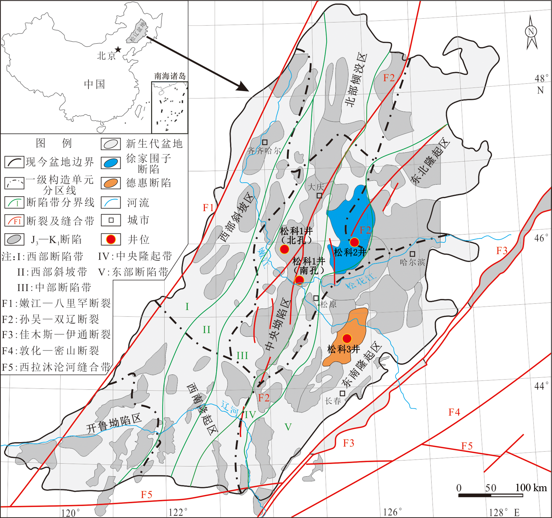
图1 松辽盆地构造单元及松辽盆地大陆科学钻探工程井位分布图(修改自文献[20⇓⇓-23])
Fig.1 Tectonic units of the Songliao Basin and location of ICDP boreholes in the Songliao Basin. Modified after [20⇓⇓-23].
| 取心次数 | 层位 | 井段/m | 进尺/m | 心长/m | 收获率/% |
|---|---|---|---|---|---|
| 1 | 泉四段 | 839.75~848.51 | 8.76 | 8.76 | 100 |
| 2 | 泉四段、泉三段 | 848.51~857.64 | 9.13 | 9.13 | 100 |
| 3 | 泉三段 | 857.64~866.97 | 9.33 | 9.28 | 99.46 |
| 4 | 泉三段 | 866.97~870.10 | 3.13 | 3.13 | 100 |
| 5 | 泉三段 | 870.10~879.71 | 9.61 | 9.41 | 97.91 |
| 6 | 泉三段 | 879.71~888.92 | 9.21 | 9.17 | 99.56 |
| 7 | 泉三段 | 888.92~898.09 | 9.17 | 9.09 | 99.12 |
| 8 | 泉三段 | 898.09~907.16 | 9.07 | 8.9 | 98.12 |
| 9 | 泉三段 | 907.16~925.23 | 18.07 | 17.2 | 95.18 |
| 10 | 泉三段 | 925.23~943.31 | 18.08 | 17.74 | 98.11 |
| 11 | 泉三段 | 943.31~961.49 | 18.18 | 18.06 | 99.33 |
| 12 | 泉三段 | 961.49~979.86 | 18.37 | 18.05 | 98.25 |
| 13 | 泉三段 | 979.86~998.09 | 18.23 | 17.82 | 97.75 |
| 14 | 泉三段 | 998.09~1 016.18 | 18.09 | 17.8 | 98.39 |
| 15 | 泉三段 | 1 016.18~1 034.16 | 17.98 | 17.6 | 97.88 |
| 16 | 泉三段 | 1 034.16~1 052.05 | 17.89 | 17.7 | 98.93 |
| 17 | 泉三段 | 1 052.05~1 070.50 | 18.45 | 17.73 | 96.09 |
| 18 | 泉三段 | 1 070.50~1 088.00 | 17.5 | 17.36 | 99.2 |
| 19 | 泉三段 | 1 088.00~1 112.67 | 24.67 | 23.99 | 97.24 |
| 20 | 泉三段 | 1 112.67~1 135.60 | 22.93 | 22.65 | 98.77 |
| 21 | 泉三段、泉二段 | 1 135.60~1 161.75 | 26.15 | 24.85 | 95.02 |
| 22 | 泉二段 | 1 161.75~1 184.24 | 22.49 | 21.37 | 95.02 |
| 23 | 泉二段 | 1 184.24~1 211.57 | 27.33 | 26.76 | 97.91 |
| 24 | 泉二段 | 1 211.57~1 237.23 | 25.66 | 25.38 | 98.9 |
| 25 | 泉二段 | 1 237.23~1 261.52 | 24.29 | 24.1 | 99.21 |
| 26 | 泉二段 | 1 261.52~1 284.99 | 23.47 | 23.15 | 98.63 |
| 27 | 泉二段 | 1 284.99~1 309.69 | 24.7 | 24.52 | 99.27 |
| 28 | 泉二段 | 1 309.69~1 336.50 | 26.81 | 26.7 | 99.58 |
| 29 | 泉二段 | 1 336.50~1 363.56 | 27.06 | 26.93 | 99.51 |
| 30 | 泉二段、泉一段 | 1 363.56~1 386.57 | 23.01 | 23.01 | 100 |
| 31 | 泉一段 | 1 386.57~1 413.57 | 27 | 26.93 | 99.74 |
| 32 | 泉一段 | 1 413.57~1 434.57 | 21 | 21 | 100 |
| 33 | 泉一段 | 1 434.57~1 461.87 | 27.3 | 27.16 | 99.48 |
| 34 | 泉一段 | 1 461.87~1 483.08 | 21.21 | 20.98 | 98.91 |
| 35 | 泉一段 | 1 483.08~1 509.45 | 26.37 | 26.22 | 99.43 |
| 36 | 泉一段 | 1 509.45~1 531.41 | 21.96 | 21.88 | 99.63 |
| 37 | 泉一段 | 1 531.41~1 558.77 | 27.36 | 27.03 | 98.79 |
| 38 | 泉一段 | 1 558.77~1 585.94 | 27.17 | 26.53 | 97.64 |
| 39 | 泉一段 | 1 585.94~1 609.07 | 23.13 | 22.87 | 98.87 |
| 40 | 泉一段 | 1 609.07~1 636.11 | 27.04 | 26.73 | 98.85 |
| 41 | 泉一段 | 1 636.11~1 663.09 | 26.98 | 26.78 | 99.25 |
| 42 | 泉一段 | 1 663.09~1 690.09 | 27 | 26.75 | 99.07 |
| 43 | 泉一段 | 1 690.09~1 717.01 | 26.92 | 26.7 | 99.18 |
| 44 | 泉一段、登娄库组 | 1 717.01~1 744.13 | 27.12 | 26.86 | 99.04 |
| 45 | 登娄库组 | 1 744.13~1 771.22 | 27.09 | 26.85 | 99.11 |
| 46 | 登娄库组 | 1 771.22~1 798.46 | 27.24 | 26.1 | 95.81 |
| 47 | 登娄库组 | 1 798.46~1 825.52 | 27.06 | 26.79 | 99 |
| 48 | 登娄库组 | 1 825.52~1 844.32 | 18.8 | 18.61 | 98.98 |
| 49 | 登娄库组 | 1 844.32~1 845.34 | 1.02 | 0.95 | 93.13 |
| 50 | 登娄库组 | 1 845.34~1 872.42 | 27.08 | 27.08 | 100 |
| 51 | 登娄库组 | 1 872.42~1 899.30 | 26.88 | 26.87 | 99.96 |
| 52 | 登娄库组 | 1 899.30~1 926.19 | 26.89 | 26.78 | 99.59 |
| 53 | 登娄库组 | 1 926.19~1 952.87 | 26.68 | 26.55 | 99.51 |
| 54 | 登娄库组 | 1 952.87~1 980.26 | 27.39 | 27.25 | 99.48 |
| 55 | 登娄库组 | 1 980.26~2 007.70 | 27.44 | 27.38 | 99.78 |
| 56 | 登娄库组 | 2 007.70~2 032.31 | 24.61 | 24.3 | 98.74 |
| 57 | 登娄库组 | 2 032.31~2 059.36 | 27.05 | 27.05 | 100 |
| 58 | 登娄库组 | 2 059.36~2 086.45 | 27.09 | 27 | 99.66 |
| 59 | 登娄库组 | 2 086.45~2 113.71 | 27.26 | 27.24 | 99.92 |
| 60 | 登娄库组 | 2 113.71~2 139.94 | 26.23 | 25.85 | 98.55 |
| 61 | 登娄库组 | 2 139.94~2 167.35 | 27.41 | 27.24 | 99.37 |
| 62 | 登娄库组 | 2 167.35~2 194.44 | 27.09 | 27.03 | 99.77 |
| 63 | 登娄库组 | 2 194.44~2 221.56 | 27.12 | 27.08 | 99.85 |
| 64 | 登娄库组 | 2 221.56~2 248.95 | 27.39 | 27.34 | 99.81 |
| 65 | 登娄库组 | 2 248.95~2 274.76 | 25.81 | 25.7 | 99.57 |
| 66 | 登娄库组 | 2 274.76~2 301.94 | 27.18 | 27.1 | 99.7 |
| 67 | 登娄库组 | 2 301.94~2 328.75 | 26.81 | 26.4 | 98.47 |
| 68 | 登娄库组 | 2 328.75~2 355.85 | 27.1 | 26.98 | 99.55 |
| 69 | 登娄库组 | 2 355.85~2 378.99 | 23.14 | 23.02 | 99.48 |
| 70 | 登娄库组、沙河子组 | 2 378.99~2 406.04 | 27.05 | 26.8 | 99.07 |
| 71 | 沙河子组 | 2 406.04~2 420.09 | 14.05 | 13.92 | 99.07 |
| 72 | 火石岭组 | 2 884.00~2 893.02 | 9.02 | 8.57 | 95.01 |
| 73 | 火石岭组 | 2 893.02~2 911.05 | 18.03 | 17.52 | 97.17 |
表1 松科3井钻井取心统计
Table 1 Coring statistics for borehole SK-3
| 取心次数 | 层位 | 井段/m | 进尺/m | 心长/m | 收获率/% |
|---|---|---|---|---|---|
| 1 | 泉四段 | 839.75~848.51 | 8.76 | 8.76 | 100 |
| 2 | 泉四段、泉三段 | 848.51~857.64 | 9.13 | 9.13 | 100 |
| 3 | 泉三段 | 857.64~866.97 | 9.33 | 9.28 | 99.46 |
| 4 | 泉三段 | 866.97~870.10 | 3.13 | 3.13 | 100 |
| 5 | 泉三段 | 870.10~879.71 | 9.61 | 9.41 | 97.91 |
| 6 | 泉三段 | 879.71~888.92 | 9.21 | 9.17 | 99.56 |
| 7 | 泉三段 | 888.92~898.09 | 9.17 | 9.09 | 99.12 |
| 8 | 泉三段 | 898.09~907.16 | 9.07 | 8.9 | 98.12 |
| 9 | 泉三段 | 907.16~925.23 | 18.07 | 17.2 | 95.18 |
| 10 | 泉三段 | 925.23~943.31 | 18.08 | 17.74 | 98.11 |
| 11 | 泉三段 | 943.31~961.49 | 18.18 | 18.06 | 99.33 |
| 12 | 泉三段 | 961.49~979.86 | 18.37 | 18.05 | 98.25 |
| 13 | 泉三段 | 979.86~998.09 | 18.23 | 17.82 | 97.75 |
| 14 | 泉三段 | 998.09~1 016.18 | 18.09 | 17.8 | 98.39 |
| 15 | 泉三段 | 1 016.18~1 034.16 | 17.98 | 17.6 | 97.88 |
| 16 | 泉三段 | 1 034.16~1 052.05 | 17.89 | 17.7 | 98.93 |
| 17 | 泉三段 | 1 052.05~1 070.50 | 18.45 | 17.73 | 96.09 |
| 18 | 泉三段 | 1 070.50~1 088.00 | 17.5 | 17.36 | 99.2 |
| 19 | 泉三段 | 1 088.00~1 112.67 | 24.67 | 23.99 | 97.24 |
| 20 | 泉三段 | 1 112.67~1 135.60 | 22.93 | 22.65 | 98.77 |
| 21 | 泉三段、泉二段 | 1 135.60~1 161.75 | 26.15 | 24.85 | 95.02 |
| 22 | 泉二段 | 1 161.75~1 184.24 | 22.49 | 21.37 | 95.02 |
| 23 | 泉二段 | 1 184.24~1 211.57 | 27.33 | 26.76 | 97.91 |
| 24 | 泉二段 | 1 211.57~1 237.23 | 25.66 | 25.38 | 98.9 |
| 25 | 泉二段 | 1 237.23~1 261.52 | 24.29 | 24.1 | 99.21 |
| 26 | 泉二段 | 1 261.52~1 284.99 | 23.47 | 23.15 | 98.63 |
| 27 | 泉二段 | 1 284.99~1 309.69 | 24.7 | 24.52 | 99.27 |
| 28 | 泉二段 | 1 309.69~1 336.50 | 26.81 | 26.7 | 99.58 |
| 29 | 泉二段 | 1 336.50~1 363.56 | 27.06 | 26.93 | 99.51 |
| 30 | 泉二段、泉一段 | 1 363.56~1 386.57 | 23.01 | 23.01 | 100 |
| 31 | 泉一段 | 1 386.57~1 413.57 | 27 | 26.93 | 99.74 |
| 32 | 泉一段 | 1 413.57~1 434.57 | 21 | 21 | 100 |
| 33 | 泉一段 | 1 434.57~1 461.87 | 27.3 | 27.16 | 99.48 |
| 34 | 泉一段 | 1 461.87~1 483.08 | 21.21 | 20.98 | 98.91 |
| 35 | 泉一段 | 1 483.08~1 509.45 | 26.37 | 26.22 | 99.43 |
| 36 | 泉一段 | 1 509.45~1 531.41 | 21.96 | 21.88 | 99.63 |
| 37 | 泉一段 | 1 531.41~1 558.77 | 27.36 | 27.03 | 98.79 |
| 38 | 泉一段 | 1 558.77~1 585.94 | 27.17 | 26.53 | 97.64 |
| 39 | 泉一段 | 1 585.94~1 609.07 | 23.13 | 22.87 | 98.87 |
| 40 | 泉一段 | 1 609.07~1 636.11 | 27.04 | 26.73 | 98.85 |
| 41 | 泉一段 | 1 636.11~1 663.09 | 26.98 | 26.78 | 99.25 |
| 42 | 泉一段 | 1 663.09~1 690.09 | 27 | 26.75 | 99.07 |
| 43 | 泉一段 | 1 690.09~1 717.01 | 26.92 | 26.7 | 99.18 |
| 44 | 泉一段、登娄库组 | 1 717.01~1 744.13 | 27.12 | 26.86 | 99.04 |
| 45 | 登娄库组 | 1 744.13~1 771.22 | 27.09 | 26.85 | 99.11 |
| 46 | 登娄库组 | 1 771.22~1 798.46 | 27.24 | 26.1 | 95.81 |
| 47 | 登娄库组 | 1 798.46~1 825.52 | 27.06 | 26.79 | 99 |
| 48 | 登娄库组 | 1 825.52~1 844.32 | 18.8 | 18.61 | 98.98 |
| 49 | 登娄库组 | 1 844.32~1 845.34 | 1.02 | 0.95 | 93.13 |
| 50 | 登娄库组 | 1 845.34~1 872.42 | 27.08 | 27.08 | 100 |
| 51 | 登娄库组 | 1 872.42~1 899.30 | 26.88 | 26.87 | 99.96 |
| 52 | 登娄库组 | 1 899.30~1 926.19 | 26.89 | 26.78 | 99.59 |
| 53 | 登娄库组 | 1 926.19~1 952.87 | 26.68 | 26.55 | 99.51 |
| 54 | 登娄库组 | 1 952.87~1 980.26 | 27.39 | 27.25 | 99.48 |
| 55 | 登娄库组 | 1 980.26~2 007.70 | 27.44 | 27.38 | 99.78 |
| 56 | 登娄库组 | 2 007.70~2 032.31 | 24.61 | 24.3 | 98.74 |
| 57 | 登娄库组 | 2 032.31~2 059.36 | 27.05 | 27.05 | 100 |
| 58 | 登娄库组 | 2 059.36~2 086.45 | 27.09 | 27 | 99.66 |
| 59 | 登娄库组 | 2 086.45~2 113.71 | 27.26 | 27.24 | 99.92 |
| 60 | 登娄库组 | 2 113.71~2 139.94 | 26.23 | 25.85 | 98.55 |
| 61 | 登娄库组 | 2 139.94~2 167.35 | 27.41 | 27.24 | 99.37 |
| 62 | 登娄库组 | 2 167.35~2 194.44 | 27.09 | 27.03 | 99.77 |
| 63 | 登娄库组 | 2 194.44~2 221.56 | 27.12 | 27.08 | 99.85 |
| 64 | 登娄库组 | 2 221.56~2 248.95 | 27.39 | 27.34 | 99.81 |
| 65 | 登娄库组 | 2 248.95~2 274.76 | 25.81 | 25.7 | 99.57 |
| 66 | 登娄库组 | 2 274.76~2 301.94 | 27.18 | 27.1 | 99.7 |
| 67 | 登娄库组 | 2 301.94~2 328.75 | 26.81 | 26.4 | 98.47 |
| 68 | 登娄库组 | 2 328.75~2 355.85 | 27.1 | 26.98 | 99.55 |
| 69 | 登娄库组 | 2 355.85~2 378.99 | 23.14 | 23.02 | 99.48 |
| 70 | 登娄库组、沙河子组 | 2 378.99~2 406.04 | 27.05 | 26.8 | 99.07 |
| 71 | 沙河子组 | 2 406.04~2 420.09 | 14.05 | 13.92 | 99.07 |
| 72 | 火石岭组 | 2 884.00~2 893.02 | 9.02 | 8.57 | 95.01 |
| 73 | 火石岭组 | 2 893.02~2 911.05 | 18.03 | 17.52 | 97.17 |
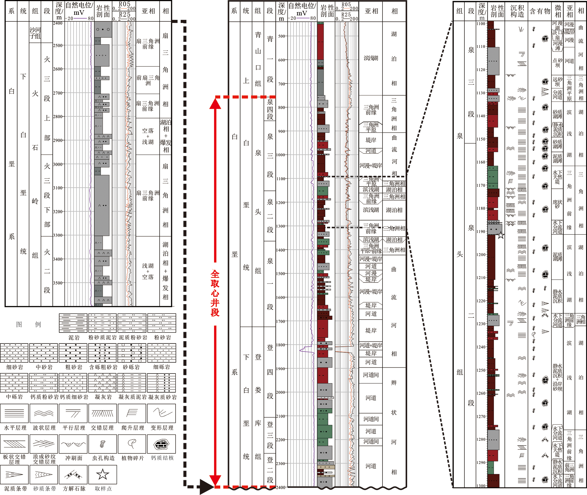
图2 松科3井岩石类型、岩性序列、沉积相柱状图及测年样品取样位置
Fig.2 Rock types, lithologic sequence, sedimentary facies histogram and the sampling location for age dating in borehole SK-3
 |
表2 松科3井沉积相类型与鉴定标准(修改自文献[28⇓⇓⇓⇓⇓⇓-35])
Table 2 Sedimentary facies types and identification criteria of borehole SK-3. Modified after [28⇓⇓⇓⇓⇓⇓-35].
| |

图3 松科3井重点研究层段典型沉积相岩心照片 a—1 069.78 m,棕灰色泥岩,可见粉砂质泥岩,破碎呈蒜瓣状,层理不明显,含钙质结核,正粒序,曲流河相河漫亚相;b—1 512.15 m,浅灰色粉砂岩,发育大量虫孔和生物扰动痕迹,正粒序,曲流河相堤岸亚相;c—1 084.2 m,灰色钙质复成分砾岩,砾石成分以钙质结核为主,含泥砾,正粒序,曲流河相河道亚相;d—1 131.47 m,灰色细砂岩,发育平行层理和波状交错层理,正粒序,三角洲平原亚相;e—1 187.74 m,浅灰色中粗粒砂岩,发育槽状交错层理,正粒序,三角洲前缘分流河道沉积;f—1 191.49 m,灰色细砂岩与绿灰色泥岩互层:泥岩水平层理,局部被冲刷为原地泥砾,砾石呈弱定向排列,砾石最大扁平面双向倾斜;砂岩平行层理发育,见低角度交错层理(冲洗层理),滨(浅)湖相沉积。
Fig.3 Core photos of typical sedimentary facies of key intervals in borehole SK-3

图4 测年样品取样位置岩心照片(a,b)及对应的薄片显微镜下照片(c—正交偏光,×4;d—正交偏光,×10)
Fig.4 Core photos (a, b), and thin sections for zircon dating with 4× (c) and 10× (d) magnifications under orthogonal polarized light

图5 代表性锆石阴极发光照片
Fig.5 Cathode luminescence images of representative zircons for U-Pb dating of core samples
 |
表3 松科3井泉头组二段沉凝灰岩碎屑锆石LA-ICP-MSU-Pb年龄测试结果
Table 3 Results of LA-ICP-MS U-Pb dating of detrital zircons from tuffite deposits
| |
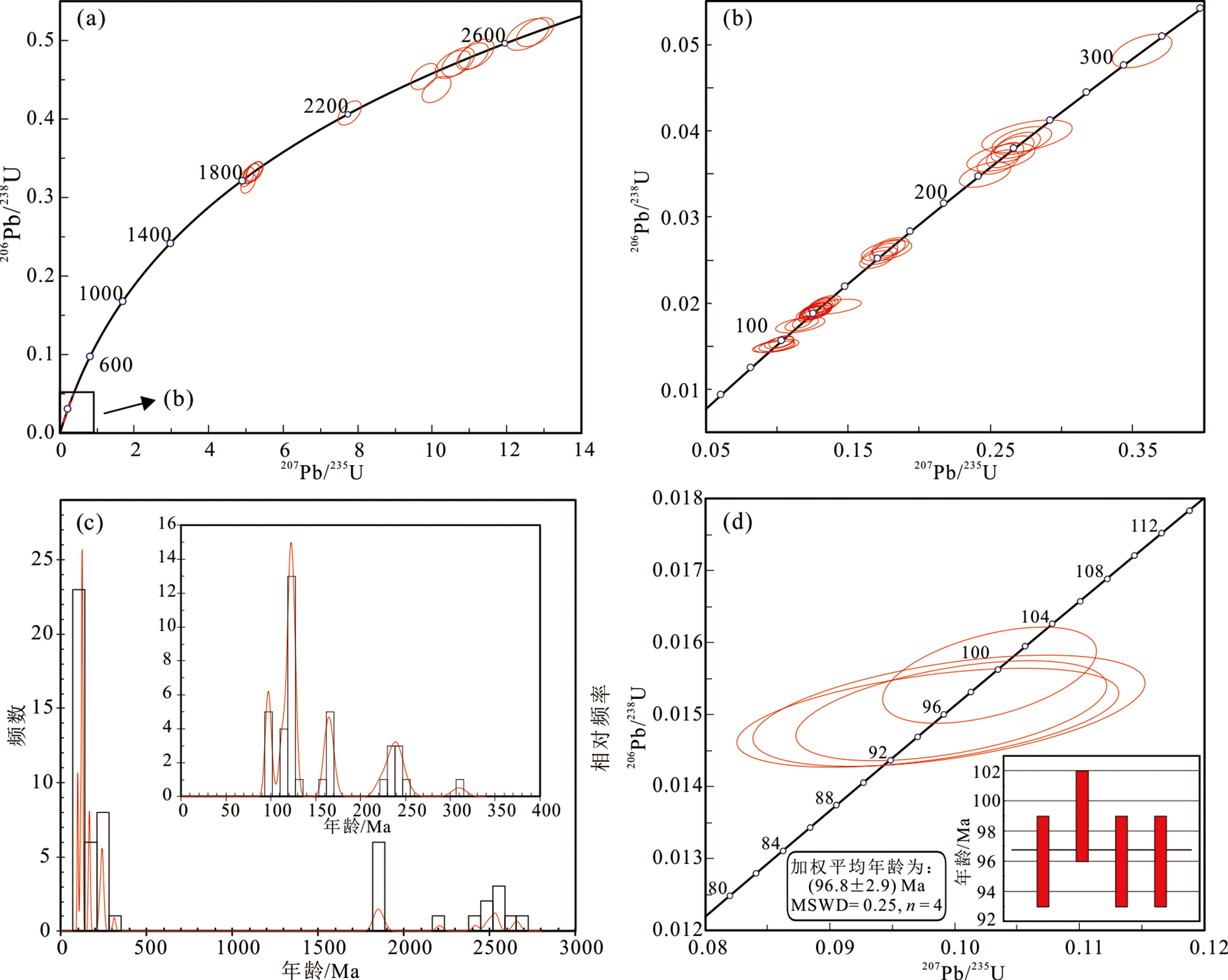
图6 锆石U-Pb年龄谐和图与频谱图
Fig.6 U-Pb Concordia plots and age spectrum diagram for zircons from core samples
| [1] |
ZHONG Y, WANG Y, JIA B, et al. A potential terrestrial Albian-Cenomanian boundary in the Yanji Basin, Northeast China[J]. Palaeogeography, Palaeoclimatology, Palaeoecology, 2021, 562: 110088.
DOI URL |
| [2] |
GALE A S, KENNEDY W J, BURNETT J A, et al. The Late Albian to Early Cenomanian succession at Mont Risou near Rosans (Drôme, SE France): an integrated study (ammonites, inoceramids, planktonic foraminifera, nannofossils, oxygen and carbon isotopes)[J]. Cretaceous Research, 1996, 17(5): 515-606.
DOI URL |
| [3] |
KENNEDY W J, GALE A S, LEES J A, et al. The Global Boundary Stratotype Section and Point (GSSP) for the base of the Cenomanian Stage, Mont Risou, Hautes-Alpes, France[J]. Episodes, 2004, 27(1): 21-32.
DOI URL |
| [4] | COHEN K M, FINNEY S C, GIBBARD P L, et al. The ICS international chronostratigraphic chart[J]. Episodes: Journal of International Geoscience, 2013, 36(3): 199-204. |
| [5] |
CRAMPTON J S, TULLOCH A J, WILSON G J, et al. Definition, age, and correlation of the Clarence Series stages in New Zealand (late Early to early Late Cretaceous)[J]. New Zealand Journal of Geology and Geophysics, 2004, 47(1): 1-19.
DOI URL |
| [6] |
ANDO A. Recent contributions to the standard Albian/Cenomanian boundary chronology from Hokkaido, Japan:a review for data reintegration and numerical age recalibration[J]. Cretaceous Research, 2016, 64: 50-58.
DOI URL |
| [7] | SAMES B, HORNE D J. 侏罗纪末至白垩纪非海相介形类生物地层学: 回顾与展望 ①[J]. 地层学杂志, 2012, 36(2): 266-268. |
| [8] |
HAQ B U. Cretaceous eustasy revisited[J]. Global and Planetary Change, 2014, 113: 44-58.
DOI URL |
| [9] | 李东津, 王光奇, 李春田. 试论松辽盆地白垩系上下统的分界[J]. 吉林地质, 1986(3): 22-29. |
| [10] | 高瑞祺, 赵传本, 郑玉龙, 等. 松辽盆地深层早白垩世孢粉组合研究[J]. 古生物学报, 1994(6): 659- 675, 785-787. |
| [11] | 于文卿, 孙希, 于恩君, 等. 松辽盆地白垩纪地层时代划分[J]. 铀矿地质, 1999(5): 2-10. |
| [12] | 黎文本. 从孢粉组合论证松辽盆地泉头组的地质时代及上、 下白垩统界线[J]. 古生物学报, 2001(2): 153-176. |
| [13] | 黄清华, 张文婧, 贾琼, 等. 松辽盆地上、 下白垩统界线划分[J]. 地学前缘, 2009, 16(6): 77-84. |
| [14] | 黄清华, 吴怀春, 万晓樵, 等. 松辽盆地白垩系综合年代地层学研究新进展[J]. 地层学杂志, 2011, 35(3): 250-257. |
| [15] | 万晓樵, 李罡, 黄清华, 等. 中国白垩纪陆相阶的划分与对比[J]. 地层学杂志, 2013, 37(4): 457-471. |
| [16] | 席党鹏, 万晓樵, 李国彪, 等. 中国白垩纪综合地层和时间框架[J]. 中国科学: 地球科学, 2019, 49(1): 257-288. |
| [17] | 王燕. 辽西-内蒙古东部地区阜新组、 孙家湾组生物地层与上、 下白垩统界线研究[D]. 北京: 中国地质大学(北京), 2020. |
| [18] | 席党鹏, 孙立新, 覃祚焕, 等. 中国白垩纪岩石地层划分和对比[J]. 地层学杂志, 2021, 45(3): 375-401. |
| [19] |
瞿雪姣, 高有峰, 林志成, 等. 松辽盆地及周缘地区侏罗系/白垩系界线区域对比特征探讨[J]. 地学前缘, 2021, 28(4): 299-315.
DOI |
| [20] |
FENG Z Q, JIA C Z, XIE X N, et al. Tectonostratigraphic units and stratigraphic sequences of the nonmarine Songliao Basin, Northeast China[J]. Basin Research, 2010, 22(1): 79-55.
DOI URL |
| [21] |
瞿雪姣, 王璞珺, 高有峰, 等. 松辽盆地断陷期火石岭组时代归属探讨[J]. 地学前缘, 2014, 21(2): 234-250.
DOI |
| [22] |
王璞珺, 赵然磊, 蒙启安, 等. 白垩纪松辽盆地: 从火山裂谷到陆内拗陷的动力学环境[J]. 地学前缘, 2015, 22(3): 99-117
DOI |
| [23] |
WANG P J, MATTERN F, DIDENKO N A, et al. Tectonics and cycle system of the Cretaceous Songliao Basin: an inverted active continental margin basin[J]. Earth-Science Reviews, 2016, 159: 82-102.
DOI URL |
| [24] | 王璞珺, 刘海波, 任延广, 等. 松辽盆地白垩系大陆科学钻探 “松科2井” 选址[J]. 地学前缘, 2017, 24(1): 216-228. |
| [25] | 王成善, 冯志强, 吴河勇, 等. 中国白垩纪大陆科学钻探工程: 松科1井科学钻探工程的实施与初步进展[J]. 地质学报, 2008(1): 9-20. |
| [26] | 高有峰, 王璞珺, 程日辉, 等. 松科1井南孔白垩系青山口组一段沉积序列精细描述: 岩石地层、 沉积相与旋回地层[J]. 地学前缘, 2009, 16(2): 314-323. |
| [27] | 刘硕, 高有峰, 尹永康, 等. 松辽盆地大陆科学钻探 “松科2井” 登娄库组二段沉积序列精细刻画及时代归属[J]. 世界地质, 2019, 38(4): 1032-1043. |
| [28] | 国家质量技术监督局. GB/T 17412.2—1998 沉积岩岩石分类和命名方案[S]. 北京: 中国标准出版社, 2000: 5-6. |
| [29] | 曾允孚, 夏文杰. 沉积岩石学[M]. 北京: 地质出版社, 1986: 219-240. |
| [30] | 冯增昭. 沉积岩石学[M]. 北京: 石油工业出版社, 1993. |
| [31] | 赵澄林, 朱筱敏. 沉积岩石学[M]. 北京: 石油工业出版社, 2001. |
| [32] | 姜在兴. 沉积学[M]. 北京: 石油工业出版社, 2003: 257-403. |
| [33] | 《地球科学大辞典》编委会. 基础科学卷: 地球科学大辞典[M]. 北京: 地质出版社, 2006. |
| [34] | 杨伟东, 关平, 李建明. 英汉沉积学解释辞典[M]. 北京: 北京大学出版社, 1991. |
| [35] | READING H G. Sedimentary environments and facies[M]. Oxford: Blackwell Scientific Publications, 1978. |
| [36] |
ANDERSON T. Correction of common lead in U-Pb analyses that do not report 204Pb[J]. Chemical Geology, 2002, 192(1): 59-79.
DOI URL |
| [37] | LUDWIG K R. Isoplot 3.00: a geochronological toolkit for Microsoft Excel[J]. Berkeley Geochronology Center Special Publication, 2003, 4: 70. |
| [38] |
PUPIN J P. Zircon and granite petrology[J]. Contributions to Mineralogy and Petrology, 1980, 73(3): 207-220.
DOI URL |
| [39] |
YUAN H, GAO S, LIU X, et al. Accurate U-Pb age and trace element determinations of zircon by laser ablation-inductively coupled plasma-mass spectrometry[J]. Geostandards and Geoanalytical Research, 2004, 28(3): 353-370.
DOI URL |
| [40] |
HE H, DENG C, WANG P, et al. Toward age determination of the termination of the Cretaceous Normal Superchron[J]. Geochemistry, Geophysics, Geosystems, 2012, 13(2): 1-20.
DOI URL |
| [41] |
WANG T, RAMEZANI J, WANG C, et al. High-precision U-Pb geochronologic constraints on the Late Cretaceous terrestrial cyclostratigraphy and geomagnetic polarity from the Songliao Basin, Northeast China[J]. Earth and Planetary Science Letters, 2016, 446: 37-44.
DOI URL |
| [42] | WU H, HINNOV L A, ZHANG S, et al. Continental geological evidence for solar system chaotic behavior in the Late Cretaceous[J/OL]. GSA Bulletin, 2022. (2022-07-06) [2023-01-10]. https://doi.org/10.1130/B36340.1 |
| [43] |
WANG T, WANG C, RAMEZANI J, et al. High-precision geochronology of the Early Cretaceous Yingcheng Formation and its stratigraphic implications for Songliao Basin, China[J]. Geoscience Frontiers, 2022, 13(4): 101386.
DOI URL |
| [44] |
MA X, WU H, FANG Q, et al. A floating astronomical time scale for the early Late Cretaceous continental strata in the Songliao Basin, northeastern China[J]. Acta Geologica Sinica (English Edition), 2020, 94(1): 27-37.
DOI URL |
| [45] |
WAN X Q, ZHAO J, SCOTT R W, et al. Late Cretaceous stratigraphy, Songliao Basin, NE China: SK1 cores[J]. Palaeogeography, Palaeoclimatology, Palaeoecology, 2013, 385: 31-43.
DOI URL |
| [46] |
WANG P, CHEN S. Cretaceous volcanic reservoirs and their exploration in the Songliao Basin, Northeast China[J]. AAPG Bulletin, 2015, 99(3): 499-523.
DOI URL |
| [1] | 王斌, 孙东生, 李阿伟, 杨跃辉, 陈群策. 松辽盆地深部基底地应力状态:来自松科2井地应力实测数据的证据[J]. 地学前缘, 2024, 31(2): 377-390. |
| [2] | 王成善, 高远, 王璞珺, 吴怀春, 吕庆田, 朱永宜, 万晓樵, 邹长春, 黄永建, 高有峰, 席党鹏, 王稳石, 贺怀宇, 冯子辉, 杨光, 邓成龙, 张来明, 王天天, 胡滨, 崔立伟, 彭诚, 余恩晓, 黄何, 杨柳, 毋正轩. 松辽盆地国际大陆科学钻探:白垩纪恐龙时代陆相地质记录[J]. 地学前缘, 2024, 31(1): 412-430. |
| [3] | 吴怀春, 李山, 王成善, 褚润健, 王璞珺, 高远, 万晓樵, 贺怀宇, 邓成龙, 杨光, 黄永建, 高有峰, 席党鹏, 王天天, 房强, 杨天水, 张世红. 松辽盆地白垩纪综合年代地层格架[J]. 地学前缘, 2024, 31(1): 431-445. |
| [4] | 李瑞磊, 杨立英, 朱建峰, 刘玉虎, 徐文, 李忠博, 樊薛沛, 冷庆磊, 张婷婷. 松辽盆地南部断陷层火山岩储层特征及油气成藏主控因素[J]. 地学前缘, 2023, 30(4): 100-111. |
| [5] | 韩双彪, 唐致远, 白松涛, 万磊, 芮宇润, 高远, 黄永建, 王成善. 元素俘获能谱在深层致密储层评价中的应用:以松科2井为例[J]. 地学前缘, 2022, 29(1): 449-458. |
| [6] | 瞿雪姣, 高有峰, 林志成, 王璞珺, 吴康军. 松辽盆地及周缘地区侏罗系/白垩系界线区域对比特征探讨[J]. 地学前缘, 2021, 28(4): 299-315. |
| [7] | 杜书恒, 梁耀欢, 师永民, 关平. 围压-孔压改变条件下致密砂岩及泥页岩泊松比变化特征及机制[J]. 地学前缘, 2021, 28(1): 411-419. |
| [8] | 牛花朋,王贵文,鲜本忠,付健伟,焦小芹,李洪娟. 深层火山碎屑熔岩形成机理及其指相意义研究:以松辽盆地庆深气田为例 [J]. 地学前缘, 2019, 26(6): 281-288. |
| [9] | 杜书恒,师永民,关平. 松辽盆地扶余低渗非均质储层压裂缝定量预测[J]. 地学前缘, 2017, 24(6): 381-389. |
| [10] | 童晓宁,胡建芳,祝孟博,彭平安,席党鹏,宋建中. 分子标志物揭示的松辽盆地晚三冬期气候环境[J]. 地学前缘, 2017, 24(1): 154-165. |
| [11] | 祝孟博,宋建中,童晓宁,胡建芳,席党鹏,曹怀仁,彭平安. 松辽盆地晚三冬期的黑碳记录及其古环境意义[J]. 地学前缘, 2017, 24(1): 166-173. |
| [12] | 曹怀仁,胡建芳,彭平安,席党鹏. 松辽盆地青山口组二段下部湖泊水体环境变化[J]. 地学前缘, 2017, 24(1): 205-215. |
| [13] | 王璞珺,刘海波,任延广,万晓樵,王树学,瞿雪姣,蒙启安,黄永建,黄清华,高有峰,王成善. 松辽盆地白垩系大陆科学钻探“松科2井”选址[J]. 地学前缘, 2017, 24(1): 216-228. |
| [14] | 高有峰,瞿雪姣,蒋丽君,王树学,王璞珺. 松辽盆地白垩系大陆科学钻探松科2井钻遇地层界面及岩性剖面预测[J]. 地学前缘, 2017, 24(1): 242-256. |
| [15] | 瞿雪姣,杨立伟,薛璇,高有峰,王璞珺. 松辽盆地白垩系大陆科学钻探松科2井:井底温度、地层压力预测[J]. 地学前缘, 2017, 24(1): 257-264. |
| 阅读次数 | ||||||
|
全文 |
|
|||||
|
摘要 |
|
|||||