地学前缘 ›› 2025, Vol. 32 ›› Issue (2): 332-345.DOI: 10.13745/j.esf.sf.2023.12.29
刘力维1,2( ), 韩坤英1,2,*(), 丁孝忠1,2, 金铭1,2, 庞健峰1,2, 王颖1,2, 邵天瑞1,2
收稿日期:2023-11-07
修回日期:2023-12-19
出版日期:2025-03-25
发布日期:2025-03-25
通信作者:
*韩坤英(1968—),女,教授级高级工程师,主要从事区域地质编图和GIS应用工作。E-mail: kunyinghan@163.com
作者简介:刘力维(1999—),男,硕士研究生,主要从事月球与行星地质编图及对比研究工作。E-mail: 543607115@qq.com
基金资助:
LIU Liwei1,2(), HAN Kunying1,2,*(), DING Xiaozhong1,2, JIN Ming1,2, PANG Jianfeng1,2, WANG Ying1,2, SHAO Tianrui1,2
Received:2023-11-07
Revised:2023-12-19
Online:2025-03-25
Published:2025-03-25
摘要:
阿波罗盆地是月球南极-艾肯盆地(SPA)中挖掘深度最深且直径最大的撞击盆地,是2024年嫦娥六号开展月球背面采样返回的预选着陆区。研究该区域的地质特征和演化历史,有助于研究月球壳幔的结构和组成、南极-艾肯构造区的形成和演化、南极-艾肯盆地的重力异常等一系列月球科学问题。本文基于多源遥感数据,以GIS为技术平台,对阿波罗盆地及邻区的地形地貌特征、岩石学特征和各种构造要素进行研究。重新划分阿波罗盆地内的玄武岩单元,利用撞击坑大小-频率定年法和更新后的月球年代函数模型,获得其绝对模式年龄。此外,厘清区域地质构造演化历史,分析区域的火山活动热演化模式,为嫦娥六号月球探测器采样返回的后续研究提供参考。研究结果如下:研究区出露的岩石以亚铁斜长岩套、亚铁苏长岩套和月海玄武岩为主,纯斜长岩和火成碎屑岩零星分布;阿波罗盆地内月海玄武岩单元的绝对模式年龄为3.47~2.57 Ga;研究区发育127条坑底断裂和14处火山口,是反映区域热演化的重要构造;研究区经过3次大型撞击,形成SPA、阿波罗和奥本海默盆地;区域火山活动从晚雨海世持续到爱拉托逊纪,至少经历了两期次玄武岩喷发事件。
中图分类号:
刘力维, 韩坤英, 丁孝忠, 金铭, 庞健峰, 王颖, 邵天瑞. 嫦娥六号探测器预选着陆区区域地质特征及演化分析[J]. 地学前缘, 2025, 32(2): 332-345.
LIU Liwei, HAN Kunying, DING Xiaozhong, JIN Ming, PANG Jianfeng, WANG Ying, SHAO Tianrui. Regional geological characteristics and evolution of the pre-selected landing area of the Chang’e-6 probe[J]. Earth Science Frontiers, 2025, 32(2): 332-345.

图1 研究区位置图 底图为嫦娥二号CCD影像图,黑色虚线为SPA盆地最佳拟合椭圆。
Fig.1 Regional location map of the study area

图2 研究区地形和月壳结构 a—LOLA高程数据和剖面线位置;b,c—质量瘤附近GRAIL布格重力异常和月壳厚度数据;d,e—A-B和C-D的地形剖面及莫霍面位置。
Fig.2 Topography and lunar crust structure of the study area

图3 阿波罗盆地及邻区岩石类型图
Fig.3 Rock types in the Apollo Basin and adjacent areas

图4 阿波罗盆地月海玄武岩单元划分
Fig.4 Division of lunar mare basalt units in the Apollo Basin
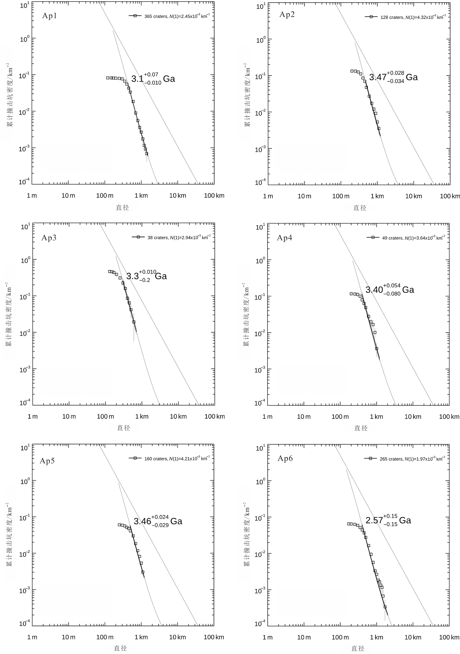
图5 月海玄武岩定年 Ap1-Ap6对应图4玄武岩单元划分。
Fig.5 Chronology of lunar mare basalts

图6 研究区盆地与撞击坑分布特征图 图中示研究区不同时代盆地和撞击坑的分布特征:a—艾肯纪;b—酒海纪;c—雨海纪;d—哥白尼纪。
Fig.6 Distribution characteristics of basins and impact craters in the study area

图7 阿波罗盆地构造解译 a-c—火山口(红色箭头)、坑底断裂(白色箭头)、穹窿(黄色箭头)和皱脊(绿色箭头)位置,底图为WAC影像;d-f—A-A'为火山口剖面线,B-B'为坑底断裂剖面线,C-C'为穹窿剖面线,D-D'为皱脊剖面线,底图为LOLA高程数据和WAC影像数据叠加;g-j—对应A-A'、B-B'、C-C'和D-D'的地形剖面。
Fig.7 Tectonic interpretation of the Apollo Basin

图8 阿波罗盆地火山活动模式图
Fig.8 Volcanic activity patterns in the Apollo Basin
| [1] | 丁孝忠, 韩坤英, 韩同林, 等. 月球虹湾幅(LQ-4)地质图的编制[J]. 地学前缘, 2012, 19(6): 15-27. |
| [2] | 王梁, 丁孝忠, 韩坤英, 等. 月球数字地质图的编制与研究[J]. 中国地质, 2015, 42(1): 331-341. |
| [3] | IVANOV M A, HIESINGER H, VAN DER BOGERT C H, et al. Geologic history of the northern portion of the South Pole-Aitken Basin on the Moon[J]. Journal of Geophysical Research: Planets, 2018, 123(10): 2585-2612. |
| [4] | JI J Z, GUO D J, LIU J Z, et al. The 1∶2500000-scale geologic map of the global Moon[J]. Science Bulletin, 2022, 67(15): 1544-1548. |
| [5] | CHEN J, LING Z C, LIU J Z, et al. Digital and global lithologic mapping of the Moon at a 1∶2500000 scale[J]. Science Bulletin, 2022, 67(20): 2050-2054. |
| [6] | LU T Q, ZHU K, CHEN S B, et al. The 1∶2500000-scale global tectonic map of the Moon[J]. Science Bulletin, 2022, 67(19): 1962-1966. |
| [7] | ROBINSON M S, BRYLOW S M, TSCHIMMEL M, et al. Lunar reconnaissance orbiter camera (LROC) instrument overview[J]. Space Science Reviews, 2010, 150(1/2/3/4): 81-124. |
| [8] | SMITH D E, ZUBER M T, NEUMANN G A, et al. Initial observations from the lunar orbiter laser altimeter (LOLA)[J]. Geophysical Research Letters, 2010, 37(L18024): 1-6. |
| [9] | ZUBER M T, SMITH D E, LEHMAN D H, et al. Gravity recovery and interior laboratory (GRAIL): mapping the lunar interior from crust to core[J]. Space Science Reviews, 2013, 178(1): 3-24. |
| [10] |
PIETERS C M, STAID M I, FISCHER E M, et al. A sharper view of impact craters from clementine data[J]. Science, 1994, 266(5192): 1844-1848.
PMID |
| [11] |
郭弟均, 刘建忠, 张莉, 等. 月球地质年代学研究方法及月面历史划分[J]. 地学前缘, 2014, 21(6): 45-61.
DOI |
| [12] | LUCEY P G. Mineral maps of the Moon[J]. Geophysical Research Letters, 2004, 31(8): 289-291. |
| [13] | YAMAMOTO S, NAKAMURA R, MATSUNAGA T, et al. Possible mantle origin of olivine around lunar impact basins detected by SELENE[J]. Nature Geoscience, 2010, 3(8): 533-536. |
| [14] | MORIARTY D P III, PIETERS C M. The nature and origin of mafic mound in the South Pole-Aitken Basin[J]. Geophysical Research Letters, 2015, 42(19): 7907-7915. |
| [15] | MELOSH H J, KENDALL J, HORGAN B, et al. South Pole-Aitken basin ejecta reveal the Moon’s upper mantle[J]. Geology, 2017, 45(12): 1063-1066. |
| [16] | 郭弟均, 刘建忠, HEADW J, 等. 月球阿波罗盆地区域月壳结构及光谱特征[J]. 深空探测学报, 2018, 5(5): 488-494. |
| [17] |
WIECZOREK M A, NEUMANN G A, NIMMO F, et al. The crust of the Moon as seen by GRAIL[J]. Science, 2013, 339(6120): 671-675.
DOI PMID |
| [18] | GREELEY R, KADEL S D, WILLIAMS D A, et al. Galileo imaging observations of lunar maria and related deposits[J]. Journal of Geophysical Research: Planets, 1993, 98(E9): 17183-17205. |
| [19] | PASCKERT J H, HIESINGER H, VAN DER BOGERT C H. Lunar farside volcanism in and around the South Pole-Aitken Basin[J]. Icarus, 2018, 299: 538-562. |
| [20] |
HARUYAMA J, OHTAKE M, MATSUNAGA T, et al. Long-lived volcanism on the lunar farside revealed by SELENE terrain camera[J]. Science, 2009, 323(5916): 905-908.
DOI PMID |
| [21] | PIETERS C M, HEAD J W III, GADDIS L, et al. Rock types of South Pole-Aitken Basin and extent of basaltic volcanism[J]. Journal of Geophysical Research: Planets, 2001, 106(E11): 28001-28022. |
| [22] | HARUYAMA J, OHTAKE M, MATSUNAGA T, et al. Planned radiometrically calibrated and geometrically corrected products of lunar high-resolution terrain camera on SELENE[J]. Advances in Space Research, 2008, 42(2): 310-316. |
| [23] | HARTMANN W K. Does crater “saturation equilibrium” occur in the solar system?[J]. Icarus, 1984, 60(1): 56-74. |
| [24] | NEUKUM G, IVANOV B, HARTMANN W. Cratering records in the inner solar system in relation to the lunar reference system[J]. Space Science Reviews, 2001, 96(1/2/3/4): 55-86. |
| [25] | YUE Z Y, DI K C, WAN W H, et al. Updated lunar cratering chronology model with the radiometric age of Chang’e-5 samples[J]. Nature Astronomy, 2022, 6(5): 541-545. |
| [26] | LIU J W, LIU J Z, YUE Z Y, et al. Characterization and interpretation of the global lunar impact basins based on remote sensing[J]. Icarus, 2022, 378: 114952. |
| [27] | HIESINGER H, VAN DER BOGERT C H, PASCKERT J, et al. New crater size-frequency distribution measurements of the South Pole-Aitken Basin[C]// MACKWELL S, STANSBERY E, DRAPER D. 43rd Lunar and Planetary Science Conference. Texas: The Woodands, 2012: 2863. |
| [28] | GARRICK-BETHELL I, ZUBER M T. Elliptical structure of the lunar South Pole-Aitken Basin[J]. Icarus, 2009, 204(2): 399-408. |
| [29] | VAUGHAN W M, HEAD J W. Impact melt differentiation in the South Pole-Aitken Basin: some observations and speculations[J]. Planetary and Space Science, 2014, 91: 101-106. |
| [30] | NEUMANN G A, ZUBER M T, WIECZOREK M A, et al. Lunar impact basins revealed by Gravity Recovery and Interior Laboratory measurements[J]. Science Advances, 2015, 1(9): e1500852. |
| [31] |
JOHNSON B C, BLAIR D M, COLLINS G S, et al. Formation of the Orientale lunar multiring basin[J]. Science, 2016, 354(6311): 441-444.
PMID |
| [32] | BAKER D M H, HEAD J W, PHILLIPS R J, et al. GRAIL gravity observations of the transition from complex crater to peak-ring basin on the Moon: implications for crustal structure and impact basin formation[J]. Icarus, 2017, 292: 54-73. |
| [33] | ORGEL C, MICHAEL G, FASSETT C I, et al. Ancient bombardment of the inner solar system: reinvestigation of the “fingerprints” of different impactor populations on the Lunar surface[J]. Journal of Geophysical Research Planets, 2018, 123(3): 748-762. |
| [34] | POTTER R W K, HEAD J W, GUO D J, et al. The Apollo peak-ring impact basin: insights into the structure and evolution of the South Pole-Aitken Basin[J]. Icarus, 2018, 306: 139-149. |
| [35] | JOZWIAK L M, HEAD J W, ZUBER M T, et al. Lunar floor-fractured craters: classification, distribution, origin and implications for magmatism and shallow crustal structure[J]. Journal of Geophysical Research: Planets, 2012, 117(E11): E11005-1-23. |
| [36] | 陆天启. 月球构造遥感识别及其演化研究[D]. 长春: 吉林大学, 2020. |
| [37] |
陆天启, 陈圣波, 朱凯. 基于GRAIL重力数据的月球深部断裂识别和空间分布研究[J]. 地球物理学报, 2019, 62(8): 2835-2844.
DOI |
| [38] | JOZWIAK L M, HEAD J W, WILSON L. Lunar floor-fractured craters as magmatic intrusions: geometry, modes of emplacement, associated tectonic and volcanic features, and implications for gravity anomalies[J]. Icarus, 2015, 248: 424-447. |
| [39] | JOZWIAK L M, HEAD J W III, NEUMANN G A, et al. Observational constraints on the identification of shallow lunar magmatism: insights from floor-fractured craters[J]. Icarus, 2017, 283: 224-231. |
| [40] | 乔乐, 陈剑, 凌宗成. 月球火山作用的地貌学特征[J]. 地质学报, 2021, 95(9): 2678-2691. |
| [41] | 欧阳自远, 刘建忠. 月球形成演化与月球地质图编研[J]. 地学前缘, 2014, 21(6): 1-6. |
| [42] | HEAD J W, WILSON L. Lunar mare volcanism: stratigraphy, eruption conditions, and the evolution of secondary crusts[J]. Geochimica et Cosmochimica Acta, 1992, 56(6): 2155-2175. |
| [43] | WIECZOREK M A, PHILLIPS R J. The“procellarum KREEP terrane”: implications for mare volcanism and lunar evolution[J]. Journal of Geophysical Research: Planets, 2000, 105(E8): 20417-20430. |
| [44] | SCHULTZ P H, CRAWFORD D A. Origin of nearside structural and geochemical anomalies on the Moon[J]. Special Paper of the Geological Society of America, 2011, 477: 141-159. |
| [45] | BAKER D M H, HEAD J W. Constraints on the depths of origin of peak rings on the Moon from Moon Mineralogy Mapper data[J]. Icarus, 2015, 258: 164-180. |
| [46] | YAMAMOTO S, NAGAOKA H, OHTAKE M, et al. Lunar mantle composition based on spectral and geologic analysis of low-Ca pyroxene- and olivine-rich rocks exposed on the lunar surface[J]. Journal of Geophysical Research: Planets, 2023, 128(5): e2023JE007817 |
| [47] | LI C L, LIU D W, LIU B, et al. Chang’E-4 initial spectroscopic identification of lunar far-side mantle-derived materials[J]. Nature, 2019, 569(7756): 378-382. |
| [48] | UEMOTO K, OHTAKE M, HARUYAMA J, et al. Evidence of impact melt sheet differentiation of the lunar South Pole-Aitken Basin[J]. Journal of Geophysical Research: Planets, 2017, 122(8): 1672-1686. |
| [1] | 王颖, 丁孝忠, 韩坤英, 陈剑, 刘敬稳, 陆天启, 王俊涛, 石成龙, 金铭, 庞健峰. 基于多源遥感数据的月球薛定谔盆地及邻区地质特征和演化分析[J]. 地学前缘, 2023, 30(4): 525-538. |
| [2] | 金铭, 丁孝忠, 韩坤英, 刘建忠, 凌宗成, 许可娟, 庞健峰, 邵天瑞. 月球地质图空间数据库设计[J]. 地学前缘, 2022, 29(2): 343-353. |
| [3] | 许可娟, 丁孝忠, 韩坤英, 刘敬稳, 凌宗成, 庞健峰, 王颖. 月球佩塔维厄斯幅(LQ-21)数字地质填图与区域地质演化特征[J]. 地学前缘, 2022, 29(2): 354-369. |
| [4] | 姚美娟,陈建平,籍进柱. 月球南海地区玄武岩厚度估算[J]. 地学前缘, 2019, 26(3): 271-281. |
| [5] | 王庆龙,刘建忠,郭弟均,籍进柱,刘敬稳,王俊涛,罗林. 月球雨海盆地多环结构的厘定及其深部构造研究[J]. 地学前缘, 2018, 25(1): 297-313. |
| [6] | 王梁, 丁孝忠, 韩同林, 韩坤英, 庞健峰, 许可娟, 刘建忠. 月球第谷撞击坑区域数字地质填图及地质地貌特征[J]. 地学前缘, 2015, 22(2): 251-262. |
| [7] | 孙灵芝, 凌宗成, 刘建忠. 月球东海盆地的矿物光谱特征及遥感探测[J]. 地学前缘, 2014, 21(6): 188-203. |
| [8] | 张渊智, 黄朝君, 周超, 陈圣波. 不同粒径的月球橄榄石二向性反射特征研究[J]. 地学前缘, 2014, 21(6): 150-154. |
| [9] | 张薛伟, 蒋云, 刘寒, 张讯与, 周贤锋, 陈媛, 汤枭, 吴昀昭. 月球火山碎屑堆积物光谱研究[J]. 地学前缘, 2014, 21(6): 137-149. |
| [10] | 凌宗成, 刘建忠, 张江, 李勃, 武中臣, 倪宇恒, 孙灵芝. 基于“嫦娥一号”干涉成像光谱仪数据的月球岩石类型填图: 以月球雨海—冷海地区(LQ-4)为例[J]. 地学前缘, 2014, 21(6): 107-120. |
| [11] | 吴昀昭. 月球反射光谱学及应用[J]. 地学前缘, 2014, 21(6): 74-87. |
| [12] | 班超, 郑永春, 张锋, 朱永超, 邹永廖. 月球风暴洋地区元素丰度研究:“嫦娥二号”X射线谱仪探测数据分析[J]. 地学前缘, 2014, 21(6): 62-73. |
| [13] | 王翔,陈建平,范海明,李珂,章浩,郑啸. 基于3D WebGIS月球地质空间数据管理系统[J]. 地学前缘, 2014, 21(6): 31-37. |
| [14] | 丁孝忠, 王梁, 韩坤英, 庞健峰, 刘建忠, 郭弟均, 丁伟翠, 剧远景. 基于ArcGIS的月球数字地质填图:以月球北极地区为例[J]. 地学前缘, 2014, 21(6): 19-30. |
| [15] | 欧阳自远, 刘建忠. 月球形成演化与月球地质图编研[J]. 地学前缘, 2014, 21(6): 1-6. |
| 阅读次数 | ||||||
|
全文 |
|
|||||
|
摘要 |
|
|||||