地学前缘 ›› 2022, Vol. 29 ›› Issue (2): 343-353.DOI: 10.13745/j.esf.sf.2021.7.12

• 月球地质与基础地质数据更新 • 上一篇    下一篇

月球地质图空间数据库设计

金铭1,2(), 丁孝忠1,2,*(), 韩坤英1,2, 刘建忠3, 凌宗成4, 许可娟1,2, 庞健峰1,2, 邵天瑞1,2   

  1. 1.中国地质科学院 地质研究所, 北京 100037
    2.中国地质调查局 全国地质编图研究中心, 北京 100037
    3.中国科学院 地球化学研究所 月球与行星科学研究中心, 贵州 贵阳 550081
    4.山东大学 空间科学研究院 山东省光学天文与日地空间环境重点实验室, 山东 威海 264209
  • 收稿日期:2021-04-30 修回日期:2021-09-18 出版日期:2022-03-25 发布日期:2022-03-31
  • 通讯作者: 丁孝忠
  • 作者简介:金 铭(1984—),女,助理研究员,主要从事地质编图与行星遥感研究。E-mail: jinmingjsh@163.com
  • 基金资助:
    国家自然科学基金项目(41941003);科学技术部科技基础性工作专项(2015FY210500);中国地质科学院地质研究所基本科研业务费项目(J2021);中国科学院前沿科学重点研究项目(QYZDY-SSW-DQC028)

Design of spatial database for the geological map of the Moon

JIN Ming1,2(), DING Xiaozhong1,2,*(), HAN Kunying1,2, LIU Jianzhong3, LING Zongcheng4, XU Kejuan1,2, PANG Jianfeng1,2, SHAO Tianrui1,2   

  1. 1. Institute of Geology, Chinese Academy of Geological Sciences, Beijing 100037, China
    2. National Geological Mapping Research Center of China Geological Survey, Beijing 100037, China
    3. Lunar and Planetary Science Research Center, Institute of Geochemistry, Chinese Academy of Sciences, Guiyang 550081, China
    4. Shandong Provincial Key Laboratory of Optical Astronomy and Solar-Terrestrial Environment, Institute of Space Sciences, Shandong University, Weihai 264209, China
  • Received:2021-04-30 Revised:2021-09-18 Online:2022-03-25 Published:2022-03-31
  • Contact: DING Xiaozhong

摘要:

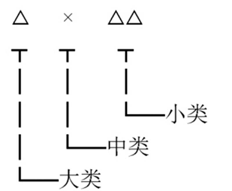
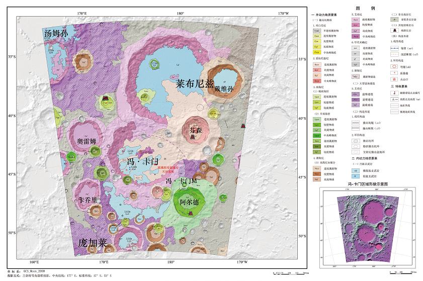
我国即将完成1: 2 500 000全月球数字地质图编制,为便于成果数据存储管理和集成共享,需要建立完备合理的空间数据库。本文基于本次编图工作实践,对月球地质图空间数据库要素内容进行了全面整理和归类。月球地质图空间数据库要素包括物质要素、构造要素、其他特殊符号、注记共4个大类,在大类基础上细分为13个中类及40个小类,并据此设计了具有可扩展性的要素分类代码。空间要素采用分层的方式进行组织管理,图层名前4位为所属图幅号,第5位为比例尺代码,其后为图层英文名称的缩写。每个要素图层与一张属性表关联,对属性表所有字段的字段名称、别名、类型、能否为空、长度、小数位及单位进行了定义和规范。本文选取月表撞击坑坑物质、月海岩石、撞击断裂及高程点要素详细阐述了其属性表结构。属性表主键为“要素标识号”,用于唯一标识某一个图元,其由图幅号、比例尺代码、要素分类代码、图元顺序码四层14位层次码构成。数据库设计遵循可扩展原则,特定区域或其他比例尺的月球地质图空间数据库建设也可参照执行,本文以月球冯·卡门撞击坑及邻区地质图为例进行了空间数据库设计。科学合理的数据库设计是数据库建设的前提,将为编图成果存储管理、集成共享与国际合作提供重要支撑。

关键词: 空间数据库, 月球地质图, 库表结构, 编码规则

Abstract:

China is about to complete the compilation of its 1: 2.5 million digital geological map of the entire lunar surface. In order to facilitate the storage, management, integration and sharing of the geological map data, it is necessary to build a comprehensive and practicable spatial database. In this paper, the geological spatial database feature classes were catalogued and classified comprehensively through mapping exercise. The feature class contains four main categories-material class, structural class, other special symbols class and annotation class, which are subdivided into 13 subcategories and 40 further subcategories. Extensible classification codes were designed based on this classification scheme. Spatial feature classes are organized and managed using layers. The layer name is formed as follows: the first four bits are the map number, the fifth bit is the scale code, and the following is the abbreviation of the English name of the layer. Each layer is associated with an attribute table. The field name, alias, type, empty or not, length, decimal places and units of all fields in the attribute table were defined and standardized. As an example the structure of the attribute table for crater materials, mare basalts, impact fractures and elevation points are described in detail. The primary key of the attribute table is “Feature_ID”, which is used to uniquely identify an element. The “Feature_ID” is composed of four 14-bit codes: map number, scale bar code, classification code and element sequence code. The database is designed following the principle of scalability so it can be referenced by spatial databases for other map areas or scales. Here, the design of a spatial database for the geological map of von Carmen impact crater is presented. Scientific and practicable database design is the premise of database construction, and it will play an important part in storage management and international sharing of the lunar mapping results.

Key words: spatial database, geologic map of the Moon, table structure, encoding rules

中图分类号: