地学前缘 ›› 2022, Vol. 29 ›› Issue (2): 354-369.DOI: 10.13745/j.esf.sf.2021.3.11
许可娟1,2( ), 丁孝忠1,2,*(), 韩坤英1,2, 刘敬稳3, 凌宗成4, 庞健峰1,2, 王颖1,2
收稿日期:2020-12-28
修回日期:2021-03-06
出版日期:2022-03-25
发布日期:2022-03-31
通信作者:
丁孝忠
作者简介:许可娟(1987—),女,博士,主要从事区域地质编图及GIS应用的研究。E-mail: 867807379@qq.com
基金资助:
XU Kejuan1,2(), DING Xiaozhong1,2,*(), HAN Kunying1,2, LIU Jingwen3, LING Zongcheng4, PANG Jianfeng1,2, WANG Ying1,2
Received:2020-12-28
Revised:2021-03-06
Online:2022-03-25
Published:2022-03-31
Contact:
DING Xiaozhong
摘要:
佩塔维厄斯幅月球地质图(LQ-21)位于近月面与远月面交接位置,又处于月海和月陆的过渡区,周边邻近酒海、丰富海、史密斯海等大型撞击盆地,是月球数字地质填图工作中的一个典型区域。研究该地区的地质发育概况有助于了解月球的发展演化历史。本文利用中国探月工程所获得的“嫦娥一号”(CE-1)CCD影像数据、干涉成像光谱仪(IIM)数据、激光高度计(LAM)数据和“嫦娥二号”(CE-2)CCD影像数据以及其他已有的月球地质资料,应用ArcGIS平台,开展月表物质成分、构造要素、地质时代信息的研究和数字填图工作,编制了1: 2 500 000佩塔维厄斯幅(LQ-21)数字月球地质图,总结了该地区区域地质演化历史并建立地质图空间数据库。
中图分类号:
许可娟, 丁孝忠, 韩坤英, 刘敬稳, 凌宗成, 庞健峰, 王颖. 月球佩塔维厄斯幅(LQ-21)数字地质填图与区域地质演化特征[J]. 地学前缘, 2022, 29(2): 354-369.
XU Kejuan, DING Xiaozhong, HAN Kunying, LIU Jingwen, LING Zongcheng, PANG Jianfeng, WANG Ying. Compilation of the geological map of the Petavius quadrangle of the Moon (LQ-21) and study on the regional geological evolution[J]. Earth Science Frontiers, 2022, 29(2): 354-369.
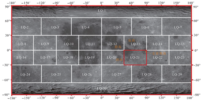
图1 1∶2 500 000佩塔维厄斯幅(LQ-21)月球地质图位置图(底图为CE-1 CCD影像数据)
Fig.1 Lunar geological overview map of the Petavius quadrangle (LQ-21) at 1∶2.5 million scale (with CE-1 CCD data overlay)

图2 1∶2 500 000佩塔维厄斯幅(LQ-21)地形地貌图(LOLA数据叠加山体阴影)
Fig.2 Topographic map of the Petavius quadrangle (LQ-21) (a shaded relief map with LOLA topographical data overlay)
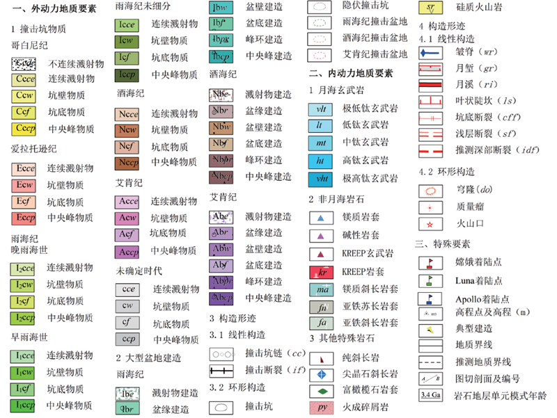
图3 月球地质要素分类体系及图式图例
Fig.3 Classification system of lunar geological elements and map legends
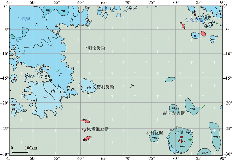
图4 佩塔维厄斯幅(LQ-21)岩石分布概略图 图例详见图3。
Fig.4 Distribution map of rock formations within LQ-21
| 地层年代 | 地质年代单元 | 年龄/Ga | |
|---|---|---|---|
| 新月宙(Neolunarisian, NL) | 哥白尼纪(Copernican, C) | 0.8~0.0 | |
| 爱拉托逊纪(Eratothenian, E) | 3.16~0.8 | ||
| 古月宙(Paleolunarisian, PL) | 雨海纪(Imbrian, I) | 晚雨海世 | 3.8~3.16 |
| 早雨海世 | 3.85~3.8 | ||
| 酒海纪(Nectarian, N) | 3.92~3.85 | ||
| 艾肯纪(Aitkenian, A) | 4.2~3.92 | ||
| 冥月宙(Eolunarisian, EL) | 前艾肯纪(pre-Aitkenian, pA) | 4.52~4.2 | |
表1 月球地质年代划分表(据文献[11,12]修改)
Table 1 Geological time scale of the Moon. Modified after [11-12].
| 地层年代 | 地质年代单元 | 年龄/Ga | |
|---|---|---|---|
| 新月宙(Neolunarisian, NL) | 哥白尼纪(Copernican, C) | 0.8~0.0 | |
| 爱拉托逊纪(Eratothenian, E) | 3.16~0.8 | ||
| 古月宙(Paleolunarisian, PL) | 雨海纪(Imbrian, I) | 晚雨海世 | 3.8~3.16 |
| 早雨海世 | 3.85~3.8 | ||
| 酒海纪(Nectarian, N) | 3.92~3.85 | ||
| 艾肯纪(Aitkenian, A) | 4.2~3.92 | ||
| 冥月宙(Eolunarisian, EL) | 前艾肯纪(pre-Aitkenian, pA) | 4.52~4.2 | |
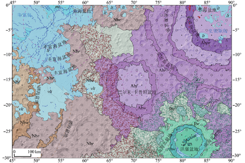
图5 佩塔维厄斯幅(LQ-21)撞击盆地分布概略图 图例详见图3。
Fig.5 Distribution map of impact basins within LQ-21
| 盆地名称 | 直径/km | 盆地模式年龄/Ga | 样品年龄/Ga | 岩浆活动年龄/Ga | 盆地序列[ | 地质年代单元 |
|---|---|---|---|---|---|---|
| 丰富海 | 690 | 4.30 | 3.69~3.36 | 7 | 艾肯纪 | |
| 巴尔末-卡普坦 | 500 | 10 | 艾肯纪 | |||
| 史密斯海 | 740 | 4.26 | 3.48~3.14 | 21 | 艾肯纪 | |
| 酒海 | 860 | 4.17 | 3.85±0.01 3.92±0.03 4.22±0.01 | 53 | 酒海纪 | |
| 危海 | 740 | 4.07 | 3.93~3.89 | 3.2~2.5 | 55 | 酒海纪 |
| 洪堡 | 199 | 3.50 | 74 | 晚雨海世 |
表2 佩塔维厄斯幅(LQ-21)地质图主要撞击盆地数据(据文献[18,32-33,35,45,50]修改)
Table 2 Basic information on impact basins within the Petavius quadrangle (LQ-21). Modified after [18,32-33,35,45,50].
| 盆地名称 | 直径/km | 盆地模式年龄/Ga | 样品年龄/Ga | 岩浆活动年龄/Ga | 盆地序列[ | 地质年代单元 |
|---|---|---|---|---|---|---|
| 丰富海 | 690 | 4.30 | 3.69~3.36 | 7 | 艾肯纪 | |
| 巴尔末-卡普坦 | 500 | 10 | 艾肯纪 | |||
| 史密斯海 | 740 | 4.26 | 3.48~3.14 | 21 | 艾肯纪 | |
| 酒海 | 860 | 4.17 | 3.85±0.01 3.92±0.03 4.22±0.01 | 53 | 酒海纪 | |
| 危海 | 740 | 4.07 | 3.93~3.89 | 3.2~2.5 | 55 | 酒海纪 |
| 洪堡 | 199 | 3.50 | 74 | 晚雨海世 |
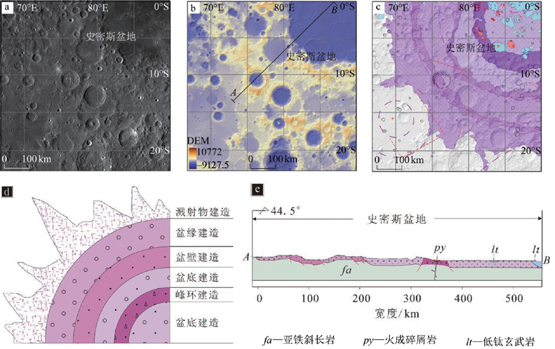
图6 史密斯海盆地建造解译 a—LRO WAC影像图;b—LOLA DEM数据,单位为m;c—史密斯海盆地物质划分图(叠加山体阴影);d—峰环盆地物质类型划分(艾肯纪);e—地质剖面示意图(剖面线由图b中切线AB生成)。图例详见图3。
Fig.6 Interpretation of Smythii basin maping results
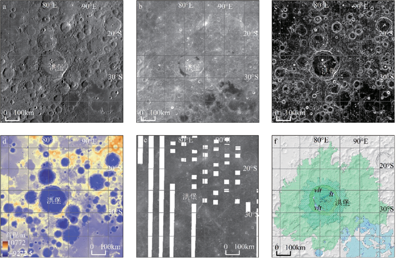
图7 洪堡盆地物质解译 a—LRO WAC影像图;b—CE1 CCD影像图;c—坡度图(LOLA DEM数据制作,z因子为3.30E-5); d—LOLA DEM数据;e—OMAT数据;f—朗伦努斯撞击坑物质划分图(叠加山体阴影)。图例详见图3。
Fig.7 Interpretation of Humboldt basin mapping results

图8 佩塔维厄斯幅内撞击坑分布概略图
Fig.8 Distribution map of craters within LQ-21
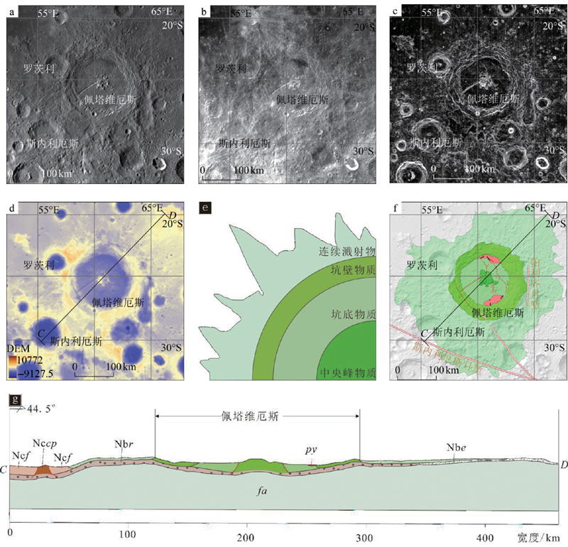
图9 佩塔维厄斯撞击坑坑物质解译 a—LRO WAC影像图;b—CE1 CCD影像图;c—坡度图(LOLA DEM数据制作,z因子为3.30E-5); d—LOLA DEM数据,单位为m;e—撞击坑物质类型划分图(早雨海世);f—佩塔维厄斯撞击坑物质划分图(叠加山体阴影);g—地质剖面示意图(剖面线由图d中切线CD生成)。图例详见图3。
Fig.9 Interpretation of Petavius crater mapping results

图10 朗伦努斯撞击坑坑物质解译 a—LRO WAC影像图;b—CE1 CCD影像图;c—坡度图(LOLA DEM数据制作,z因子为3.30E-5); d—LOLA DEM数据,单位为m;e—OMAT数据;f—朗伦努斯撞击坑物质划分图(叠加山体阴影)。图例详见图3。
Fig.10 The interpretation of Crater Langrenus Materials
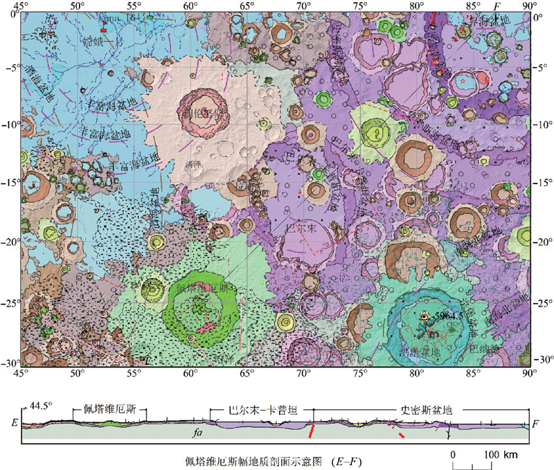
图11 佩塔维厄斯幅(LQ-21)月球地质图 图例详见图3。
Fig.11 The geological map of Petavius quadrangle (LQ-21) of the Moon
| [1] | 欧阳自远, 刘建忠. 月球形成演化与月球地质图编研[J]. 地学前缘, 2014, 21(6):1-6. |
| [2] | 陈建平, 丁孝忠, 王翔, 等. 月球地质研究与编图[M]. 北京: 地质出版社, 2014: 6-26. |
| [3] | HODGES C. Geologic map of the Petavius Quadrangle of the Moon[CM]. Reston, VA: US Geological Survey, 1973. |
| [4] | HODGES C. Geologic map of the Langrenus Quadrangle of the Moon[CM]. Reston, VA: US Geological Survey, 1973. |
| [5] | WILHELMS D E, FAROUK E B. Geologic map of the east side of the Moon[CM]. Reston, VA: US Geological Survey, 1977. |
| [6] | 丁孝忠, 韩坤英, 韩同林, 等. 月球虹湾幅(LQ-4)地质图的编制[J]. 地学前缘, 2012, 19(6):15-27. |
| [7] | WILHELMS D E, MCCAULEY J F, TRASK N J. The geologic history of the Moon[M]. Washington DC: US Geological Survey, 1987. |
| [8] | LOSIAK A, WILHELMS D E, BYRNE C J, et al. A new lunar impact crater database[C]. Lunar and Planetary Science Conference. Houston: NASA, 2009, 40:1532. |
| [9] | 陈琼, 郑勇, 苏牡丹, 等. 月球地图投影理论和方法研究[J]. 测绘通报, 2006(4):26-30. |
| [10] | 龚明劼, 张鹰, 张芸. 卫星遥感制图最佳影像空间分辨率与地图比例尺关系探讨[J]. 测绘科学, 2009, 34(4):232-233, 60. |
| [11] | 郭弟均, 刘建忠, 张莉, 等. 月球地质年代学研究方法及月面历史划分[J]. 地学前缘, 2014, 21(6):45-61. |
| [12] | GUO D J, LIU J Z, ZHANG L, et al. A lunar time scale from geodynamic evolution perspective[C]. Lunar & Planetary Science Conference. Houston: NASA, 2016, 47:1744. |
| [13] | 凌宗成, 张江, 刘建忠, 等. 嫦娥一号干涉成像光谱仪数据再校正与全月铁钛元素反演[J]. 岩石学报, 2016, 32(1):87-98. |
| [14] | 刘建忠, 籍进柱, 郭弟均, 等. 月球云海地区1: 2 500 000地质图编研进展[J]. 矿物岩石地球化学通报, 2017, 36(增刊1):1-15. |
| [15] | 罗林, 刘建忠, 张莉, 等. 月球线性构造分类体系研究[J]. 岩石学报, 2017, 33(10):3285-3301. |
| [16] | LIU J, GUO D. Lunar geological timescale[M/OL]//CUDNIK B. Encyclopedia of lunar science, Berlin: Springer International Publishing, 2018. https://doi.org/10.1007/978-3-319-05546-6_63-1 . |
| [17] | 陆天启, 陈圣波, 朱凯. 基于GRAIL重力数据的月球深部断裂识别和空间分布研究[J]. 地球物理学报, 2019, 62(8):2835-2844. |
| [18] | LIU J W, LIU J Z, ZHANG L. New global lunar impact basins’ map based on remote sensing interpretation[C]. Lunar & Planetary Science Conference. Houston: NASA, 2020, 51:1940. |
| [19] | WANG J T, KRESLAVSKY M A, LIU J Z, et al. Quantitative characterization of impact crater materials on the moon: changes in topographic roughness and thermophysical properties with age[J]. Journal of Geophysical Research: Planets, 2020, 125(10):E006091. |
| [20] | 许可娟, 王梁, 韩坤英, 等. 1: 2 500 000月球地质图符号库的设计与实现[J]. 地球科学, 2020, 45(7):2650-2661. |
| [21] | 凌宗成, 刘建忠, 张江, 等. 基于“嫦娥一号”干涉成像光谱仪数据的月球岩石类型填图:以月球雨海—冷海地区(LQ-4)为例[J]. 地学前缘, 2014, 21(6):107-120. |
| [22] | CAHILL J T, LUCEY P G. Radiative transfer modeling of lunar highlands spectral classes and relationship to lunar samples[J]. Journal of Geophysical Research: Planets, 2007, 112(E10):E10007. |
| [23] | TAYLOR G J, WARREN P, RYDER G, et al. Lunar source book[M]. Cambridge: Cambridge University Press, 1991: 183-284. |
| [24] | 李泳泉, 刘建忠, 欧阳自远, 等. 月球表面岩石类型的分布特征:基于Lunar Prospector (LP)伽马射线谱仪探测数据的反演[J]. 岩石学报, 2007, 23(5):1169-1174. |
| [25] |
SHEARER C K, ELARDO S M, PETRO N E, et al. Origin of the lunar highlands Mg-suite: an integrated petrology, geochemistry, chronology, and remote sensing perspective[J]. American Mineralogist, 2015, 100(1):294-325.
DOI URL |
| [26] | GUSTAFSON J O, BELL J F III, GADDIS L R, et al. Characterization of previously unidentified lunar pyroclastic deposits using Lunar Reconnaissance Orbiter Camera data[J]. Journal of Geophysical Research: Planets, 2012, 117(E12): E00H25-1-E00H25-21. |
| [27] | YAMAMOTO S, NAKAMURA R, MATSUNAGA T, et al. Massive layer of pure anorthosite on the Moon[J]. Geophysical Research Letters, 2012, 39(13):34-47. |
| [28] |
DONALDSON HANNA K L, CHEEK L C, PIETERS C M, et al. Global assessment of pure crystalline plagioclase across the Moon and implications for the evolution of the primary crust[J]. Journal of Geophysical Research: Planets, 2014, 119(7):1516-1545.
DOI URL |
| [29] |
PRISSEL T C, PARMAN S W, JACKSON C R M, et al. Pink Moon: the petrogenesis of pink spinel anorthosites and implications concerning Mg-suite magmatism[J]. Earth and Planetary Science Letters, 2014, 403:144-156.
DOI URL |
| [30] |
WATTERS T R, ROBINSON M S, BANKS M E, et al. Recent extensional tectonics on the moon revealed by the lunar reconnaissance orbiter camera[J]. Nature Geoscience, 2012, 5(3):181-185.
DOI URL |
| [31] |
JOZWIAK L M, HEAD J W, WILSON L. Lunar floor-fractured craters as magmatic intrusions: geometry, modes of emplacement, associated tectonic and volcanic features, and implications for gravity anomalies[J]. Icarus, 2015, 248:424-447.
DOI URL |
| [32] | HIESINGER H, HEAD J W, WOLF, et al. New ages for basalts in Mare Fecunditatis based on crater size-frequency measurements[C]. Lunar & Planetary Science Conference. Houston: NASA, 2006, 37:1151. |
| [33] | HIESINGER H, HEAD J W, WOLF U, et al. Ages and stratigraphy of lunar mare basalts: a synjournal[J]. Special Paper of the Geological Society of America, 2011, 477:1-51. |
| [34] | SPUDIS P D. The geology of multi-ring impact basins[M]. Cambridge: Cambridge University Press, 1993. |
| [35] |
ORGEL C, MICHAEL G, FASSETT C I, et al. Ancient bombardment of the inner solar system: reinvestigation of the “fingerprints” of different impactor populations on the lunar surface[J]. Journal of Geophysical Research: Planets, 2018, 123(3):748-762.
DOI URL |
| [36] |
YUE Z, LI W, DI K, et al. Global mapping and analysis of lunar wrinkle ridges[J]. Journal of Geophysical Research: Planets, 2015, 120(5):978-994.
DOI URL |
| [37] | GILLIS J J, SPUDIS P D. Geology of the Smythii and Marginis region of the Moon: using integrated remotely sensed data[J]. Journal of Geophysical Research: Planets, 2000, 105(E2):4217-4233. |
| [38] |
SCHULTZ P H, SPUDIS P D. Beginning and end of lunar mare volcanism[J]. Nature, 1983, 302(5905):233-236.
DOI URL |
| [39] |
WANG X M, QIU D G. Lunar cryptomare: new insights into the Balmer-kapteyn region[J]. Journal of Geophysical Research: Planets, 2018, 123(12):3238-3255.
DOI URL |
| [40] |
WHITTEN J L, HEAD J W. Lunar cryptomaria: physical characteristics, distribution, and implications for ancient volcanism[J]. Icarus, 2015, 247:150-171.
DOI URL |
| [41] |
BAKER D M H, HEAD J W, FASSETT C I, et al. The transition from complex crater to peak-ring basin on the Moon: new observations from the Lunar Orbiter Laser Altimeter (LOLA) instrument[J]. Icarus, 2011, 214(2):377-393.
DOI URL |
| [42] |
GADDIS L R, STAID M I, TYBURCZY J A, et al. Compositional analyses of lunar pyroclastic deposits[J]. Icarus, 2003, 161(2):262-280.
DOI URL |
| [43] | JOZWIAK L M, HEAD J W, ZUBER M T, et al. Lunar floor-fractured craters: classification, distribution, origin and implications for magmatism and shallow crustal structure[J]. Journal of Geophysical Research: Planets, 2012, 117(E11): E11005-1-E11005-23. |
| [44] | JOZWIAK L M, HEAD J W, WILSON L. An analysis of eruption styles in lunar floor-fractured craters[C]. Lunar & Planetary Science Conference. Houston: NASA, 2016, 47:1169. |
| [45] |
MARTINOT M, BESSE S, FLAHAUT J, et al. Mineralogical diversity and geology of Humboldt crater derived using moon mineralogy mapper data[J]. Journal of Geophysical Research Planets, 2018, 123(2):612-629.
DOI URL |
| [46] | HARTMANN W K. Radial structures surrounding lunar basins, I-Orientale and other systems[J]. Lunar and Planetary Laboratory, 1964, 2(36):175-192. |
| [47] |
SCHULTZ P H. Floor-fractured lunar craters[J]. The Moon, 1976, 15(3/4):241-273.
DOI URL |
| [48] | NEUMANN G A, ZUBER M T, WIECZOREK M A, et al. Lunar impact basins revealed by Gravity Recovery and Interior Laboratory measurements[J]. Science Advances, 2015, 1(9):e1500852. |
| [49] | AMBROSE W A, WILLIAMS D A. Recent advances and current research issues in lunar stratigraphy[M]. Boulder: Geological Society of America, 2011: 1-144. |
| [50] |
LEE D C, HALLIDAY A N, SNYDER G A, et al. Age and origin of the Moon[J]. Science, 1997, 278(5340):1098-1103.
DOI URL |
| [1] | 王颖, 丁孝忠, 韩坤英, 陈剑, 刘敬稳, 陆天启, 王俊涛, 石成龙, 金铭, 庞健峰. 基于多源遥感数据的月球薛定谔盆地及邻区地质特征和演化分析[J]. 地学前缘, 2023, 30(4): 525-538. |
| [2] | 金铭, 丁孝忠, 韩坤英, 刘建忠, 凌宗成, 许可娟, 庞健峰, 邵天瑞. 月球地质图空间数据库设计[J]. 地学前缘, 2022, 29(2): 343-353. |
| [3] | 姚美娟,陈建平,籍进柱. 月球南海地区玄武岩厚度估算[J]. 地学前缘, 2019, 26(3): 271-281. |
| [4] | 王庆龙,刘建忠,郭弟均,籍进柱,刘敬稳,王俊涛,罗林. 月球雨海盆地多环结构的厘定及其深部构造研究[J]. 地学前缘, 2018, 25(1): 297-313. |
| [5] | 王梁, 丁孝忠, 韩同林, 韩坤英, 庞健峰, 许可娟, 刘建忠. 月球第谷撞击坑区域数字地质填图及地质地貌特征[J]. 地学前缘, 2015, 22(2): 251-262. |
| [6] | 孙灵芝, 凌宗成, 刘建忠. 月球东海盆地的矿物光谱特征及遥感探测[J]. 地学前缘, 2014, 21(6): 188-203. |
| [7] | 张渊智, 黄朝君, 周超, 陈圣波. 不同粒径的月球橄榄石二向性反射特征研究[J]. 地学前缘, 2014, 21(6): 150-154. |
| [8] | 张薛伟, 蒋云, 刘寒, 张讯与, 周贤锋, 陈媛, 汤枭, 吴昀昭. 月球火山碎屑堆积物光谱研究[J]. 地学前缘, 2014, 21(6): 137-149. |
| [9] | 凌宗成, 刘建忠, 张江, 李勃, 武中臣, 倪宇恒, 孙灵芝. 基于“嫦娥一号”干涉成像光谱仪数据的月球岩石类型填图: 以月球雨海—冷海地区(LQ-4)为例[J]. 地学前缘, 2014, 21(6): 107-120. |
| [10] | 吴昀昭. 月球反射光谱学及应用[J]. 地学前缘, 2014, 21(6): 74-87. |
| [11] | 班超, 郑永春, 张锋, 朱永超, 邹永廖. 月球风暴洋地区元素丰度研究:“嫦娥二号”X射线谱仪探测数据分析[J]. 地学前缘, 2014, 21(6): 62-73. |
| [12] | 王翔,陈建平,范海明,李珂,章浩,郑啸. 基于3D WebGIS月球地质空间数据管理系统[J]. 地学前缘, 2014, 21(6): 31-37. |
| [13] | 丁孝忠, 王梁, 韩坤英, 庞健峰, 刘建忠, 郭弟均, 丁伟翠, 剧远景. 基于ArcGIS的月球数字地质填图:以月球北极地区为例[J]. 地学前缘, 2014, 21(6): 19-30. |
| [14] | 欧阳自远, 刘建忠. 月球形成演化与月球地质图编研[J]. 地学前缘, 2014, 21(6): 1-6. |
| [15] | 孙灵芝,凌宗成,刘建忠. 美国阿波罗月球样品的处理与保存[J]. 地学前缘, 2012, 19(6): 128-136. |
| 阅读次数 | ||||||
|
全文 |
|
|||||
|
摘要 |
|
|||||