地学前缘 ›› 2023, Vol. 30 ›› Issue (4): 525-538.DOI: 10.13745/j.esf.sf.2022.9.11
• 非主题来稿选登 • 上一篇
王颖1,2( ), 丁孝忠1,2,*(), 韩坤英1,2, 陈剑3, 刘敬稳4, 陆天启5, 王俊涛4, 石成龙1,2, 金铭1,2, 庞健峰1,2
收稿日期:2022-06-10
修回日期:2022-09-08
出版日期:2023-07-25
发布日期:2023-07-07
通信作者:
*丁孝忠(1963—),男,研究员,博士生导师,主要从事区域地质和地质编图研究工作。E⁃mail: xiaozhongding@sina.com
作者简介:王 颖(1997—),女,博士研究生,主要从事月球与行星地质编图与对比研究工作。E-mail: wymaggie0312@163.com
基金资助:
WANG Ying1,2(), DING Xiaozhong1,2,*(), HAN Kunying1,2, CHEN Jian3, LIU Jingwen4, LU Tianqi5, WANG Juntao4, SHI Chenglong1,2, JIN Ming1,2, PANG Jianfeng1,2
Received:2022-06-10
Revised:2022-09-08
Online:2023-07-25
Published:2023-07-07
摘要:
薛定谔盆地位于月球背面南极-艾肯盆地西南部的盆底与盆缘过渡处,盆地结构较为完整,形成于晚雨海世,是典型的峰环盆地,研究该区域地质演化历史有助于研究月球峰环盆地的演化过程。本文利用多源遥感数据并综合前人研究成果,对研究区开展了区域地质综合分析,主要包括地质地貌特征、岩石类型分布、构造要素以及盆地的演化过程等。与前人相比,使用较新的遥感数据和撞击坑统计年代学模型对盆地内的月海玄武岩进行了分布范围厘定和定年,得到了更精确的年龄,丰富了研究区内的构造形迹数据库,探讨了更具综合性的区域地质演化过程。得到的结果如下:研究区内出露的岩石以亚铁斜长岩套、亚铁苏长岩套和镁质斜长岩套为主,月海玄武岩、纯斜长岩、富橄榄石岩套以及火成碎屑岩零星分布,两块月海玄武岩单元的绝对模式年龄分别为3.26和3.36 Ga,为晚雨海世玄武岩;研究区内9类构造发育,其中坑底断裂、质量瘤和火山口可能是在盆地后续的重力均衡过程中逐渐形成的;薛定谔盆地的形成过程主要分为撞击成盆前、成盆期以及成盆后改造期3个阶段。
中图分类号:
王颖, 丁孝忠, 韩坤英, 陈剑, 刘敬稳, 陆天启, 王俊涛, 石成龙, 金铭, 庞健峰. 基于多源遥感数据的月球薛定谔盆地及邻区地质特征和演化分析[J]. 地学前缘, 2023, 30(4): 525-538.
WANG Ying, DING Xiaozhong, HAN Kunying, CHEN Jian, LIU Jingwen, LU Tianqi, WANG Juntao, SHI Chenglong, JIN Ming, PANG Jianfeng. Geological characteristics and evolution of the Schrödinger basin and adjacent areas: Insights from multi-source remote sensing data[J]. Earth Science Frontiers, 2023, 30(4): 525-538.

图1 月球南极-艾肯地区影像图
Fig.1 Satellite image of the South Pole-Aitken region showing the surface features of the lunar peak-ring basins

图2 1∶2 500 000薛定谔盆地及邻区地质图
Fig.2 1∶2500000 geological map of the Schrödinger basin and adjacent areas
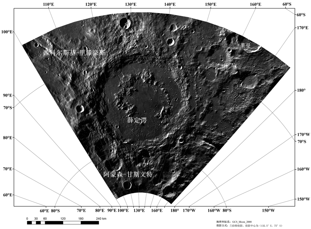
图3 薛定谔盆地的WAC影像图
Fig.3 WAC image of the Schrödinger basin

图4 薛定谔盆地地形特征 (a)—LOLA高程图;(b)—剖面线AB、CD对应的剖面图;(c)—坡度图;(d)—表面粗糙度图。
Fig.4 Topographic features of the Schrödinger basin

图5 薛定谔盆地岩石分布概略图
Fig.5 Lithological map of the Schrödinger basin and adjacent area
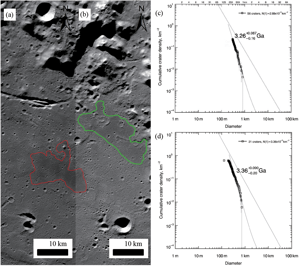
图6 薛定谔盆地中月海玄武岩分布位置及定年结果 (a)Kaguya TC数据TCO_MAPs02_S72E132S75E135SC;(b)Kaguya TC数据TCO_ MAPs02_S72E135S75E138SC;(c)绿色玄武岩单元定年结果;(d)红色玄武岩单元定年结果。
Fig.6 Distribution of basalt units in the Schrödinger basin (a, b) and the dating results (c, d)
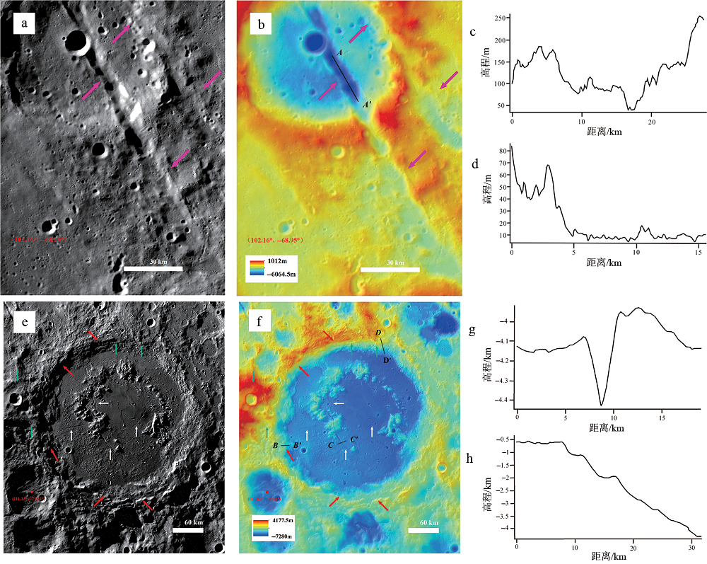
图7 薛定谔盆地线性构造解译结果 a—撞击坑链(粉色箭头)分布位置,底图为WAC影像;b—A—A'为撞击坑链高程剖面线,底图为LOLA高程数据和WAC影像数据叠加;c、d—A—A'、B—B'的地形剖面;e—撞击断裂(红色箭头)、盆底断裂(白色箭头)和浅层断裂(绿色箭头)分布位置,底图为WAC影像;f—B—B'、C—C'、D—D'分别为撞击断裂、盆底断裂和浅层断裂剖面线,底图为LOLA高程数据和WAC影像数据叠加;g、h—C—C'、D—D'的地形剖面。
Fig.7 Interpreted linear structures in the Schrödinger basin

图8 薛定谔盆地环形构造解译结果 a、b—质量瘤(黑色箭头)附近GRAIL布格重力异常和月壳厚度数据;c、d—A—A' 的重力异常剖面和B—B'的地形剖面;e—火山口(红色箭头)附近WAC影像;f—火山口(红色箭头)附近LOLA高程数据和WAC影像叠加。
Fig.8 Interpreted circular structures in the Schrödinger basin

图9 薛定谔盆地形成演化过程示意图
Fig.9 Schematic diagram describing the formation and evolution of the Schrödinger basin
| [1] | 刘敬稳, 刘建忠, 郭弟均, 等. 月球东海盆地综合解析与撞击初始条件的研究[J]. 岩石学报, 2016, 32(1): 135-143. |
| [2] | 刘敬稳. 全月盆地地质解译与时空演化研究[D]. 贵阳: 中国科学院地球化学研究所, 2022:19-25. |
| [3] | 郭弟均, 刘建忠, 籍进柱, 等. 月球的全球构造格架初探[J]. 地球物理学报, 2016, 59(10): 3543-3554. |
| [4] | WILHELMS D E, HOWARD K A, WILSHIRE H G. Geologic map of the south side of the Moon[M]. Reston, Va.: The Survey, 1979 |
| [5] |
SHOEMAKER E M, ROBINSON M S, ELIASON E M. The south pole region of the moon as seen by clementine[J]. Science, 1994, 266(5192): 1851-1854.
PMID |
| [6] | AMBROSE W A, WILLIAMS D A. Recent advances and current research issues in lunar stratigraphy[M]. Boulder, Colo.: Geological Society of America, 2011. |
| [7] |
KRAMER G Y, KRING D A, NAHM A L, et al. Spectral and photogeologic mapping of Schrödinger Basin and implications for post-South Pole-Aitken impact deep subsurface stratigraphy[J]. Icarus, 2013, 223(1): 131-148.
DOI URL |
| [8] |
YAMAMOTO S, NAKAMURA R, MATSUNAGA T, et al. Possible mantle origin of olivine around lunar impact basins detected by SELENE[J]. Nature Geoscience, 2010, 3(8): 533-536.
DOI |
| [9] | YAMAMOTO S, NAKAMURA R, MATSUNAGA T, et al. Massive layer of pure anorthosite on the Moon[J]. Geophysical Research Letters, 2012, 39(13): 34-47. |
| [10] |
SMITH D E, ZUBER M T, JACKSON G B, et al. The lunar orbiter laser altimeter investigation on the lunar reconnaissance orbiter mission[J]. Space Science Reviews, 2010, 150(1/2/3/4): 209-241.
DOI URL |
| [11] |
ROBINSON M S, BRYLOW S M, TSCHIMMEL M, et al. Lunar reconnaissance orbiter camera (LROC) instrument overview[J]. Space Science Reviews, 2010, 150(1/2/3/4): 81-124.
DOI URL |
| [12] |
KONOPLIV A S, PARK R S, YUAN D N, et al. The JPL lunar gravity field to spherical harmonic degree 660 from the GRAIL Primary Mission[J]. Journal of Geophysical Research: Planets, 2013, 118(7): 1415-1434.
DOI URL |
| [13] | SMITH D E, ZUBER M T, NEUMANN G A, et al. Initial observations from the lunar orbiter laser altimeter (LOLA)[J]. Geophysical Research Letters, 2010, 37(18): 1-6. |
| [14] |
CHEN J, LING Z C, LIU J Z, et al. Digital and global lithologic mapping of the Moon at a 1∶2,500,000 scale[J]. Science Bulletin, 2022, 67(20): 2050-2054.
DOI URL |
| [15] | LAWRENCE D J, FELDMAN W C, ELPHIC R C, et al. Iron abundances on the lunar surface as measured by the Lunar Prospector gammer-ray and neutron spectrometers[J]. Journal of Geophysical Research, 2002, 107(E12): 1-26. |
| [16] |
MYRIAM L, LUCEY PAUL G, ALEX C. Compositional maps of the lunar polar regions derived from the kaguya spectral profiler and the lunar orbiter laser altimeter data[J]. The Planetary Science Journal, 2022, 3(3):1-14.
DOI |
| [17] | BOARDMAN J W, PIETERS C M, GREEN R O, et al. Measuring moonlight: an overview of the spatial properties, lunar coverage, selenolocation, and related Level 1B products of the Moon Mineralogy Mapper[J]. Journal of Geophysical Research, 2011, 116: E00G14. |
| [18] |
NOZETTE S, RUSTAN P, PLEASANCE L P, et al. The clementine mission to the moon: scientific overview[J]. Science, 1994, 266(5192): 1835-1839.
PMID |
| [19] |
DONALDSON H K L, CHEEK L C, PIETERS C M, et al. Global assessment of pure crystalline plagioclase across the Moon and implications for the evolution of the primary crust[J]. Journal of Geophysical Research: Planets, 2014, 119(7): 1516-1545.
DOI URL |
| [20] |
OHTAKE M, MATSUNAGA T, HARUYAMA J, et al. The global distribution of pure anorthosite on the Moon[J]. Nature, 2009, 461(7261): 236-240.
DOI |
| [21] |
ARNOLD J A, GLOTCH T D, LUCEY P G, et al. Constraints on olivine-rich rock types on the Moon as observed by Diviner and M3: implications for the formation of the lunar crust[J]. Journal of Geophysical Research: Planets, 2016, 121(7): 1342-1361.
DOI URL |
| [22] |
HARUYAMA J, OHTAKE M, MATSUNAGA T, et al. Planned radiometrically calibrated and geometrically corrected products of lunar high-resolution Terrain Camera on SELENE[J]. Advances in Space Research, 2007, 42(2): 310-316.
DOI URL |
| [23] |
YUE Z Y, DI K C, WAN W H, et al. Updated lunar cratering chronology model with the radiometric age of Chang’e-5 samples[J]. Nature Astronomy, 2022, 6(5): 541-545.
DOI |
| [24] |
HARTMANN W K. Does crater “saturation equilibrium” occur in the solar system?[J]. Icarus, 1984, 60(1): 56-74.
DOI URL |
| [25] | NEUKUM G, IVANOV B A, HARTMANN W K. Cratering Records in the Inner Solar System in Relation to the Lunar Reference System[C]// KALLENBACH R, GEISS J, HARTMANN W K. Chronology and Evolution of Mars. Dordrecht: Springer, 2001: 55-86. |
| [26] |
LU T Q, ZHU K, CHEN S B, et al. The 1∶2,500,000-scale global tectonic map of the Moon[J]. Science Bulletin, 2022, 67(19): 1962-1966.
DOI URL |
| [27] |
WIECZOREK M A, NEUMANN G A, NIMMO F, et al. The crust of the moon as seen by GRAIL[J]. Science, 2013, 339(6120): 671-675.
DOI PMID |
| [28] | 陆天启. 月球构造遥感识别及其演化研究[D]. 长春: 吉林大学, 2020: 28-51. |
| [29] | 陆天启, 陈圣波, 朱凯. 基于GRAIL重力数据的月球深部断裂识别和空间分布研究[J]. 地球物理学报, 2019, 62(8): 2835-2844. |
| [30] |
ANDREWS-HANNA J C, ASMAR S W, HEAD J W, et al. Ancient igneous intrusions and early expansion of the moon revealed by GRAIL gravity gradiometry[J]. Science, 2013, 339(6120): 675-678.
DOI URL |
| [31] |
WOOD J A, DICKEY J S J, MARVIN U B, et al. Lunar anorthosites[J]. Science, 1970, 167(3918): 602-604.
PMID |
| [32] |
WARREN P H. The magma ocean concept and lunar evolution[J]. Annual Review of Earth and Planetary Sciences, 1985, 13: 201-240.
DOI URL |
| [33] |
SHEARER C K. Thermal and magmatic evolution of the moon[J]. Reviews in Mineralogy and Geochemistry, 2006, 60(1): 365-518.
DOI URL |
| [34] |
DOWTY E, PRINZ M, KEIL K. Ferroan anorthosite: a widespread and distinctive lunar rock type[J]. Earth and Planetary Science Letters, 1974, 24(1): 15-25.
DOI URL |
| [35] | CINTALA M J, GRIEVE R A F. The effects of differential scaling of impact melt and crater dimensions on lunar and terrestrial craters: some brief examples[M]// Geological Society of America Special Papers. Boulder: Geological Society of America, 1992: 51-60. |
| [36] |
PIETERS C M, TOMPKINS S, HEAD J W, et al. Mineralogy of the Mafic Anomaly in the South Pole-Aitken Basin: implications for excavation of the lunar mantle[J]. Geophysical Research Letters, 1997, 24(15): 1903-1906.
DOI URL |
| [37] |
NAKAMURA R, MATSUNAGA T, OGAWA Y, et al. Ultramafic impact melt sheet beneath the South Pole-Aitken Basin on the Moon[J]. Geophysical Research Letters, 2009, 36(22): L22202.
DOI URL |
| [38] |
POTTER R W K, COLLINS G S, KIEFER W S, et al. Constraining the size of the South Pole-Aitken Basin impact[J]. Icarus, 2012, 220(2): 730-743.
DOI URL |
| [39] |
HURWITZ D M, KRING D A. Differentiation of the South Pole-Aitken Basin impact melt sheet: implications for lunar exploration[J]. Journal of Geophysical Research: Planets, 2014, 119(6): 1110-1133.
DOI URL |
| [40] | PIETERS C M, HEAD J W, GADDIS L, et al. Rock types of South Pole-Aitken basin and extent of basaltic volcanism[J]. Journal of Geophysical Research: Planets, 2001, 106(E11):28001-28022. |
| [41] |
SHEARER C K, PAPIKE J J. Early crustal building processes on the moon: models for the petrogenesis of the magnesian suite[J]. Geochimica et Cosmochimica Acta, 2005, 69(13): 3445-3461.
DOI URL |
| [42] |
SHEARER C K, ELARDO S M, PETRO N E, et al. Origin of the lunar Highlands Mg-suite: an integrated petrology, geochemistry, chronology, and remote sensing perspective[J]. American Mineralogist, 2015, 100(1): 294-325.
DOI URL |
| [43] |
XU X Q, HUI H J, CHEN W, et al. Formation of lunar Highlands anorthosites[J]. Earth and Planetary Science Letters, 2020, 536: 116138.
DOI URL |
| [44] |
SCHULTZ P H, CRAWFORD D A. Origin and implications of non-radialimbrium sculpture on the moon[J]. Nature, 2016, 535(7612): 391-394.
DOI |
| [45] |
SCHULTZ P H. Atmospheric effects on ejecta emplacement and crater formation on Venus from Magellan[J]. Journal of Geophysical Research, 1992, 97(E10): 16183.
DOI URL |
| [46] |
PIERAZZO E, MELOSH H J. Understanding oblique impacts from experiments, observations, and modeling[J]. Annual Review of Earth and Planetary Sciences, 2000, 28: 141-167.
PMID |
| [47] | XU L Y, XIE M G. Ejectathickness distribution of the Schrödinger Basin on the moon[J]. Journal of Geophysical Research: Planets, 2020, 125(12): e2020JE006506. |
| [48] | CINTALA M J, GRIEVE R A F. Scaling impact melting and crater dimensions: implications for the lunar cratering record[J]. Meteoritics & Planetary Science, 1998, 33(4): 889-912. |
| [49] | CINTALA M J, GRIEVE R A F. Scaling impact melting and crater dimensions: implications for the lunar cratering record[J]. Meteoritics & Planetary Science, 1998, 33(6): 1343. |
| [50] | FASSETT C I, HEAD J W, SMITH D E, et al. Thickness of proximal ejecta from the Orientale Basin from Lunar Orbiter Laser Altimeter (LOLA) data: implications for multi-ring basin formation[J]. Geophysical Research Letters, 2011, 38(17): L17201. |
| [51] |
GARRICK-BETHELL I, ZUBER M T. Elliptical structure of the lunar South Pole-Aitken Basin[J]. Icarus, 2009, 204(2): 399-408.
DOI URL |
| [52] | CROFT S K. Cratering flow fields: implications for the excavation and transient expansion stages of crater formation[J]. Proceedings of Lunar and Planetary Science Conference, 1980, 11:2347-2378. |
| [53] |
MCGETCHIN T R, SETTLE M, HEAD J W. Radial thickness variation in impact crater ejecta: implications for lunar basin deposits[J]. Earth and Planetary Science Letters, 1973, 20(2): 226-236.
DOI URL |
| [54] |
ANDREWS-HANNA J C. The origin of the non-mare mascon gravity anomalies in lunar basins[J]. Icarus, 2013, 222(1): 159-168.
DOI URL |
| [55] |
SCHULTZ P H. Floor-fractured lunar craters[J]. The Moon, 1976, 15(3/4): 241-273.
DOI URL |
| [56] |
WICHMAN R W, SCHULTZ P H. Floor-fractured craters in Mare Smythii and west of Oceanus Procellarum: implications of crater modification by viscous relaxation and igneous intrusion models[J]. Journal of Geophysical Research, 1995, 100(E10): 21201.
DOI URL |
| [57] |
WICHMAN R W, SCHULTZ P H. Crater-centered laccoliths on the moon: modeling intrusion depth and magmatic pressure at the crater taruntius[J]. Icarus, 1996, 122(1): 193-199.
DOI URL |
| [1] | 许可娟, 丁孝忠, 韩坤英, 刘敬稳, 凌宗成, 庞健峰, 王颖. 月球佩塔维厄斯幅(LQ-21)数字地质填图与区域地质演化特征[J]. 地学前缘, 2022, 29(2): 354-369. |
| [2] | 欧阳自远, 刘建忠. 月球形成演化与月球地质图编研[J]. 地学前缘, 2014, 21(6): 1-6. |
| [3] | 陈建平, 王翔, 王楠, 李婧, 姚美娟, 李洪克. 基于嫦娥数据澄海—静海幅地质图编研[J]. 地学前缘, 2014, 21(6): 7-18. |
| [4] | 丁孝忠, 王梁, 韩坤英, 庞健峰, 刘建忠, 郭弟均, 丁伟翠, 剧远景. 基于ArcGIS的月球数字地质填图:以月球北极地区为例[J]. 地学前缘, 2014, 21(6): 19-30. |
| [5] | 丁孝忠,韩坤英,韩同林,剧远景,庞健峰,丁伟翠,王梁. 月球虹湾幅(LQ-4)地质图的编制[J]. 地学前缘, 2012, 19(6): 15-24. |
| [6] | 韩坤英,庞健峰,丁孝忠,韩同林,剧远景,范本贤,丁伟翠,王振洋. 基于ArcGIS的月球虹湾地区数字地质图编制研究[J]. 地学前缘, 2012, 19(6): 104-109. |
| 阅读次数 | ||||||
|
全文 |
|
|||||
|
摘要 |
|
|||||