| [1] |
张国伟, 孟庆任, 赖绍聪. 秦岭造山带的结构构造[J]. 中国科学: B辑, 1995, 25(9):994-1003.
|
| [2] |
许志琴, 李源, 梁凤华, 等. “秦岭—大别—苏鲁”造山带中“古特提斯缝合带”的连接[J]. 地质学报, 2015, 89(4):671-680.
|
| [3] |
董树文, 张岳桥, 李秋生. 论大巴山陆内造山带[M]. 北京: 地质出版社, 2014: 322-325.
|
| [4] |
任纪舜, 朱俊宾, 李崇, 等. 秦岭造山带是印支碰撞造山带吗?[J]. 地球科学, 2019, 44(5):1476-1486.
|
| [5] |
张国伟, 郭安林, 董云鹏, 等. 关于秦岭造山带[J]. 地质力学学报, 2019, 25(5):746-768.
|
| [6] |
张先康, 杨卓欣, 徐朝繁, 等. 阿尼玛卿缝合带东段上地壳结构: 马尔康—碌曲—古浪深地震测深剖面结果[J]. 地震学报, 2007, 29(6):592-604.
|
| [7] |
陈小斌, 臧绍先, 魏荣强. 稳定的鄂尔多斯地块在整体运动吗?[J]. 地球物理学报, 2011, 54(7):1750-1757.
|
| [8] |
朱日祥. “华北克拉通破坏”重大研究计划结题综述[J]. 中国科学基金, 2018, 32(3):282-290.
|
| [9] |
李克勤. 鄂尔多斯盆地大地构造发展对油气的控制作用[M]. 北京: 石油工业出版社, 2002, 426-439.
|
| [10] |
张岳桥, 廖昌珍, 施炜, 等. 鄂尔多斯盆地周边地带新构造演化及其区域动力学背景[J]. 高校地质学报, 2006, 12(3):285-297.
|
| [11] |
车自成, 罗金海, 刘良. 中国及其邻区区域大地构造学[M]. 北京: 科学出版社, 2011: 284-296.
|
| [12] |
张岳桥, 廖昌珍. 晚中生代—新生代构造体制转换与鄂尔多斯盆地改造[J]. 中国地质, 2006, 33(1):28-40.
|
| [13] |
邓起东, 程绍平, 闵伟, 等. 鄂尔多斯块体新生代构造活动和动力学的讨论[J]. 地质力学学报, 1999, 5(3):13-21.
|
| [14] |
张岳桥, VERGELY P, MERCIER J L. 华北地区上新世至第四纪断裂作用型式与左旋扩展[J]. 地质力学学报, 1999, 5(3):40-46.
|
| [15] |
陈小斌, 臧绍先, 刘永岗, 等. 鄂尔多斯地块的现今水平运动状态及其与周缘地块的相互作用[J]. 中国科学院研究生院学报, 2005, 22(3):309-314.
|
| [16] |
FAN J X, MA J, GAN W J. Movement of Ordos block and alternation of activity along its boundaries[J]. Science in China: Earth Sciences, 2003, 46(2):168-180.
|
| [17] |
徐锡伟, 程国良, 马杏垣, 等. 华北及其邻区块体转动模式和动力来源[J]. 地球科学: 中国地质大学学报, 1994, 19(2):129-138.
|
| [18] |
李智超, 李文厚, 李永项, 等. 渭河盆地新生代沉积相研究[J]. 古地理学报, 2015, 17(4):529-540.
|
| [19] |
韩恒悦, 张逸, 袁志祥. 渭河断陷盆地带的形成演化及断块运动[J]. 地震研究, 2002, 25(4):362-368.
|
| [20] |
张国伟, 孟庆任, 于在平, 等. 秦岭造山带的造山过程及其动力学特征[J]. 中国科学D辑: 地球科学, 1996, 26(3):193-200.
|
| [21] |
李春昱, 刘仰文, 朱宝清, 等. 秦岭及祁连山构造发展史[M]. 北京: 地质出版社, 1978: 174-187.
|
| [22] |
董云鹏, 张国伟, 赵霞, 等. 北秦岭元古代构造格架与演化[J]. 大地构造与成矿学, 2003, 27(2):115-124.
|
| [23] |
DONG Y P, ZHANG G W, NEUBAUER F, et al. Tectonic evolution of the Qinling orogen, China: review and synjournal[J]. Journal of Asian Earth Sciences, 2011, 41(3):213-237.
DOI
URL
|
| [24] |
闫臻, 王宗起, 王涛, 等. 秦岭造山带泥盆系形成构造环境: 来自碎屑岩组成和地球化学方面的约束[J]. 岩石学报, 2007, 23(5):1023-1042.
|
| [25] |
王宗起, 闫全人, 闫臻, 等. 秦岭造山带主要大地构造单元的新划分[J]. 地质学报, 2009, 83(11):1527-1546.
|
| [26] |
张国伟, 董云鹏, 赖绍聪, 等. 秦岭—大别造山带南缘勉略构造带与勉略缝合带[J]. 中国科学D辑: 地球科学, 2003, 33(12):1121-1135.
|
| [27] |
董树文, 施炜, 张岳桥, 等. 大巴山晚中生代陆内造山构造应力场[J]. 地球学报, 2010, 31(6):769-780.
|
| [28] |
张艳妮, 李荣西, 刘海青, 等. 四川盆地北缘大巴山前陆构造中—新生代构造隆升史[J]. 地球科学与环境学报, 2014, 36(1):230-238.
|
| [29] |
贾承造, 魏国齐, 李本亮, 等. 中国中西部两期前陆盆地的形成及其控气作用[J]. 石油学报, 2003, 24(2):13-17.
|
| [30] |
DONG S, GAO R, YIN A, et al. What drove continued continent-continent convergence after ocean closure? Insights from high-resolution seismic-reflection profiling across the Daba Shan incentral China[J]. Geology, 2013, 41(6):671-674.
DOI
URL
|
| [31] |
张岳桥, 董树文, 李建华, 等. 中生代多向挤压构造作用与四川盆地的形成和改造[J]. 中国地质, 2011, 38(2):233-250.
|
| [32] |
刘树根, 邓宾, 李智武, 等. 盆山结构与油气分布: 以四川盆地为例[J]. 岩石学报, 2011, 27(3):621-635.
|
| [33] |
LI H Q, GAO R, XIONG X S, et al. Moho fabrics of North Qinling Belt, Weihe Graben and Ordos Block in China constrained from large dynamite shots[J]. Geophysical Journal International, 2017, 209(2):643-653.
DOI
URL
|
| [34] |
任隽, 冯希杰, 王夫运, 等. 深地震反射剖面揭示的渭河盆地西安坳陷的地壳精细结构[J]. 地球物理学报, 2013, 56(2):513-521.
|
| [35] |
任隽, 彭建兵, 王夫运, 等. 渭河盆地及邻区地壳深部结构特征研究[J]. 地球物理学报, 2012, 55(9):2939-2947.
|
| [36] |
滕吉文, 李松岭, 张永谦, 等. 秦岭造山带与沉积盆地和结晶基底地震波场及动力学响应[J]. 地球物理学报, 2014, 57(3):770-788.
|
| [37] |
滕吉文, 李松岭, 张永谦, 等. 秦岭造山带与邻域华北克拉通和扬子克拉通的壳、幔精细速度结构与深层过程[J]. 地球物理学报, 2014, 57(10):3154-3175.
|
| [38] |
司芗, 滕吉文, 刘有山, 等. 秦岭造山带与南北相邻地带远震接收函数与地壳结构[J]. 地球物理学报, 2016, 59(4):1321-1334.
|
| [39] |
王谦身, 滕吉文, 张永谦, 等. 陕渝黔桂1 800 km超长探测剖面重力异常场特征及深部地壳结构探榷[J]. 地球物理学报, 2016, 59(11):4139-4152.
|
| [40] |
王谦身, 滕吉文, 张永谦, 等. 中秦岭地带重力异常特征及地壳结构的探榷[J]. 地球物理学报, 2013, 56(12):3999-4008.
|
| [41] |
冯红武, 颜文华, 郭瑛霞, 等. 利用背景噪声成像技术反演陕西及邻区地壳剪切波速度结构[J]. 地震工程学报, 2019, 41(4):978-990.
|
| [42] |
刘庚, 高原, 石玉涛. 秦岭造山带及其两侧区域地壳剪切波分裂[J]. 地球物理学报, 2017, 60(6):2326-2337.
|
| [43] |
常利军, 丁志峰, 王椿镛. 华北中西部和青藏高原东北缘上地幔各向异性变形特征[J]. 地球物理学报, 2021, 64(1):114-130.
|
| [44] |
胡国泽, 滕吉文, 阮小敏, 等. 秦岭造山带和邻域磁异常特征及结晶基底变异分析[J]. 地球物理学报, 2014, 57(2):556-571.
|
| [45] |
程顺有, 张国伟, 李立. 秦岭造山带岩石圈电性结构及其地球动力学意义[J]. 地球物理学报, 2003, 46(3):390-397.
|
| [46] |
吕宏斌, 叶高峰, 金胜, 等. 鄂尔多斯地块—扬子地块深部电性结构特征及其动力学意义[J]. 地质论评, 2020, 66(4):813-828.
|
| [47] |
张国伟, 陈家义. 秦岭造山带大地构造图[M]. 北京: 科学出版社, 1996.
|
| [48] |
ZELT C A. ZPLOT: an interactive plotting and picking program for seismic data [EB/OL]. Cambridge: Bullard Lab, University of Cambridge, 1994.[2020-08-15]. http://www.soest.hawaii.edu/users/bzelt/zp/zp.html .
|
| [49] |
VIDALE J E. Finite-difference calculation of traveltimes in three dimensions[J]. GEOPHYSICS, 1990, 55(5):521-526.
DOI
URL
|
| [50] |
HOLE J A. Nonlinear high-resolution three-dimensional seismic travel time tomography[J]. Journal of Geophysical Research: Solid Earth, 1992, 97(B5):6553-6562.
|
| [51] |
任战利, 崔军平, 郭科, 等. 鄂尔多斯盆地渭北隆起抬升期次及过程的裂变径迹分析[J]. 科学通报, 2015, 60(14):1298-1309.
|
| [52] |
孟庆任. 秦岭的由来[J]. 中国科学: 地球科学, 2017, 47(4):412-420.
|
| [53] |
刘春花, 吴才来, 郜源红, 等. 南秦岭东江口、柞水和梨园堂花岗岩类锆石LA-ICP-MS U-Pb年代学与锆石Lu-Hf同位素组成[J]. 岩石学报, 2014, 30(8):2402-2420.
|
| [54] |
胡健民, 孟庆任, 陈虹, 等. 秦岭造山带内宁陕断裂带构造演化及其意义[J]. 岩石学报, 2011, 27(3):657-671.
|
| [55] |
李建华, 张岳桥, 徐先兵, 等. 北大巴山凤凰山岩体锆石U-Pb LA-ICP-MS年龄及其构造意义[J]. 地质论评, 2012, 58(3):581-593.
|
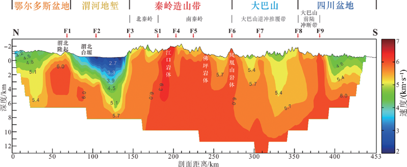
 ), 王海燕1, 高锐1,2, 卢占武1, 李洪强3, 侯贺晟3, 熊小松3, 叶卓3