Earth Science Frontiers ›› 2025, Vol. 32 ›› Issue (4): 222-234.DOI: 10.13745/j.esf.sf.2025.4.75
Previous Articles Next Articles
CHEN Yonghua1( ), HOU Weisheng2,3,*(), GUO Qingfeng1, YANG Songhua2, YE Shuwan2, LI Xin2
Received:2025-01-20
Revised:2025-05-10
Online:2025-07-25
Published:2025-08-04
CLC Number:
CHEN Yonghua, HOU Weisheng, GUO Qingfeng, YANG Songhua, YE Shuwan, LI Xin. Study on stochastic reconstruction methods for 3D geological structures along metro lines[J]. Earth Science Frontiers, 2025, 32(4): 222-234.

Fig.1 Bedrock map of the study area
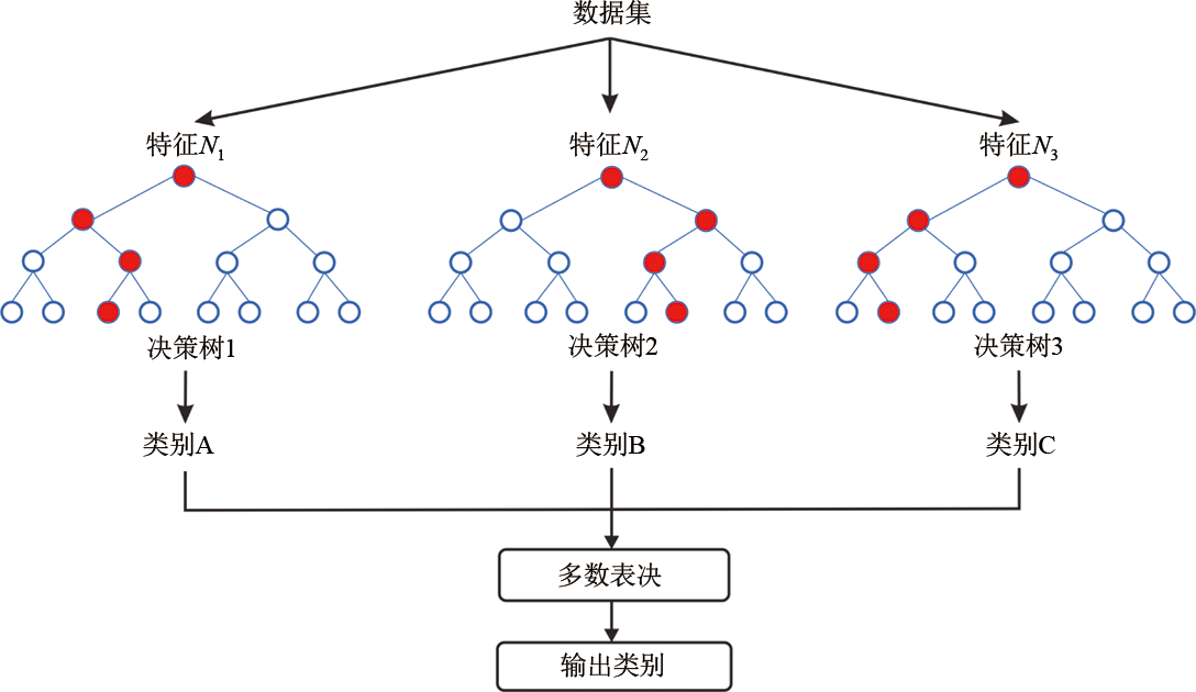
Fig.2 Schematic chart of classifier of RF

Fig.3 The schematic chart of improved DL+MPS method for constructing 3D geological model
| 参数设置 | 搜索空间 | |
|---|---|---|
| 超参数 | 隐藏层数 | [1, 10] |
| 隐藏层神经元数 | 50n (n∈[1, 10]) | |
| 学习率 | [10-5, 10-1] | |
| 批量训练样本数量 | 2n (n∈[5, 10]) | |
| 网络训练周期 | 100n (n∈[1, 10]) | |
| 评估指标 | 均方误差损失 | 最小化指标 |
| 搜索周期 | 30 | |
Table 1 AFCDNN hyperparameters for constructing geological surfaces
| 参数设置 | 搜索空间 | |
|---|---|---|
| 超参数 | 隐藏层数 | [1, 10] |
| 隐藏层神经元数 | 50n (n∈[1, 10]) | |
| 学习率 | [10-5, 10-1] | |
| 批量训练样本数量 | 2n (n∈[5, 10]) | |
| 网络训练周期 | 100n (n∈[1, 10]) | |
| 评估指标 | 均方误差损失 | 最小化指标 |
| 搜索周期 | 30 | |
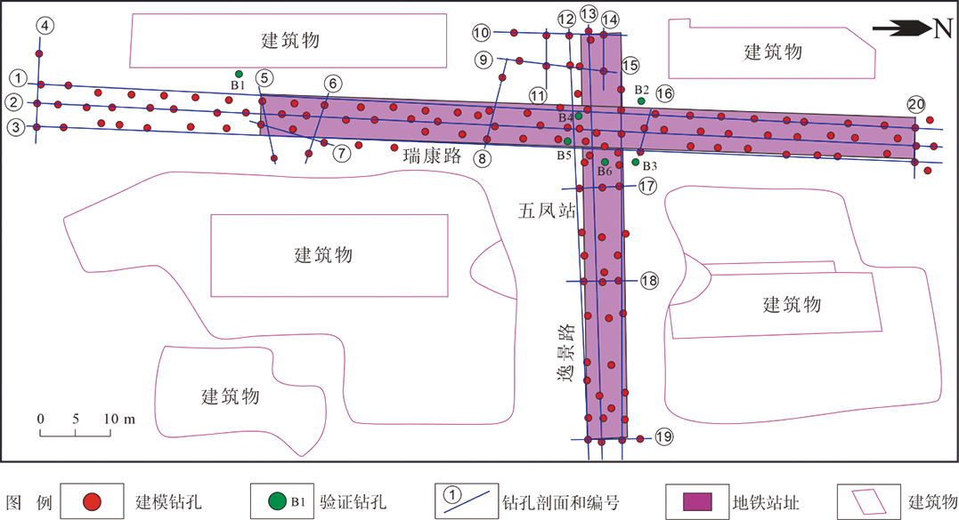
Fig.4 Distribution of boreholes and cross-sections in the study area

Fig.5 The spatial distribution patterns of geological bodies simulated using different methods

Fig.6 Comparison of fault fracture zone morphology simulated using different methods
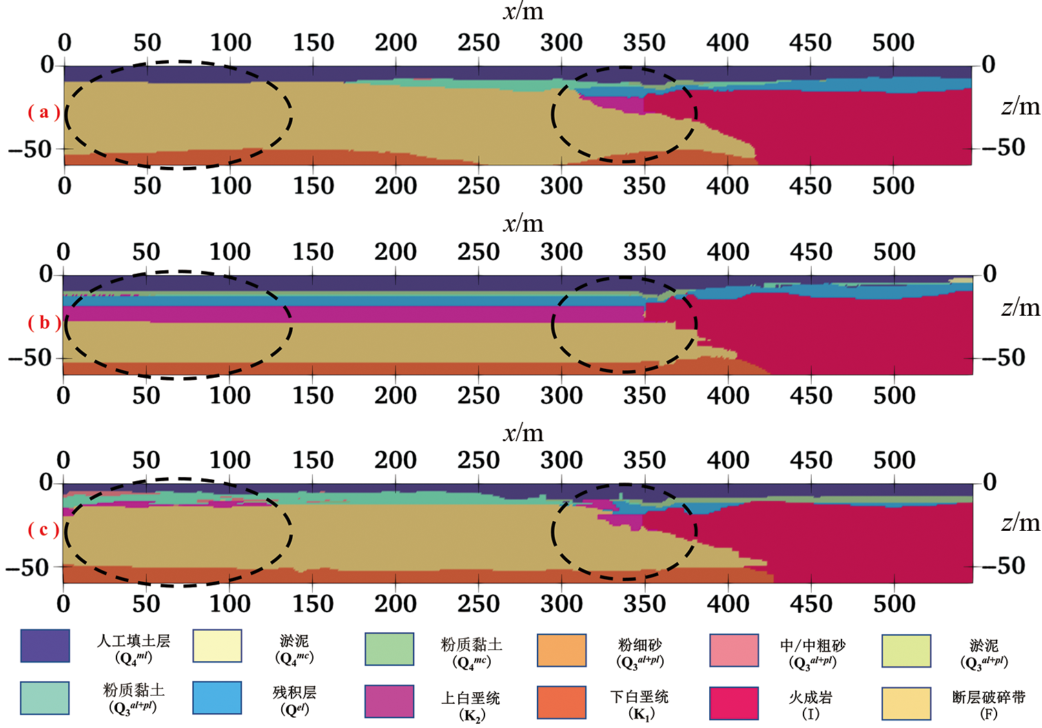
Fig.7 Comparison of slices simulated using different methods (EW=180)
| 方法 | 准确率/% | 精确率/% | 召回率/% | F1分数/% |
|---|---|---|---|---|
| DL+MPS | 99.16 | 98.92 | 98.91 | 98.91 |
| RF | 99.60 | 98.68 | 98.14 | 98.40 |
| XGBoost | 98.64 | 95.67 | 95.31 | 95.49 |
Table 2 The values of evaluation indicators for 3D geological model by different methods
| 方法 | 准确率/% | 精确率/% | 召回率/% | F1分数/% |
|---|---|---|---|---|
| DL+MPS | 99.16 | 98.92 | 98.91 | 98.91 |
| RF | 99.60 | 98.68 | 98.14 | 98.40 |
| XGBoost | 98.64 | 95.67 | 95.31 | 95.49 |

Fig.8 Confusion matrix of 3D models by different methods

Fig.9 The ROC curves of different methods
| 钻孔编号 | 不同方法模拟结果钻孔验证准确率/% | ||
|---|---|---|---|
| DL+MPS | RF | XGBoost | |
| B1 | 79.17 | 81.25 | 77.08 |
| B2 | 83.33 | 80.21 | 80.24 |
| B3 | 73.33 | 69.93 | 72.27 |
| B4 | 74.14 | 71.42 | 72.21 |
| B5 | 87.50 | 89.09 | 83.52 |
| B6 | 81.67 | 79.73 | 80.77 |
| 平均值 | 79.86 | 78.61 | 77.68 |
Table 3 The borehole dispersion values of different method
| 钻孔编号 | 不同方法模拟结果钻孔验证准确率/% | ||
|---|---|---|---|
| DL+MPS | RF | XGBoost | |
| B1 | 79.17 | 81.25 | 77.08 |
| B2 | 83.33 | 80.21 | 80.24 |
| B3 | 73.33 | 69.93 | 72.27 |
| B4 | 74.14 | 71.42 | 72.21 |
| B5 | 87.50 | 89.09 | 83.52 |
| B6 | 81.67 | 79.73 | 80.77 |
| 平均值 | 79.86 | 78.61 | 77.68 |
| 方法 | 训练时间(相对值) | 调参复杂度 | 特征工程需求 |
|---|---|---|---|
| DL+MPS | 高(需多轮 迭代) | 极高(层数、激活 函数和优化器等) | 高(需标准化和 处理缺失值) |
| RF | 低 | 低(主要调树 数量和深度) | 低(容忍缺失 值和噪声) |
| XGBoost | 中 | 中(学习率、树 深度和正则化项) | 中(需处理类别 型特征) |
Table 4 Efficiency comparison of different methods
| 方法 | 训练时间(相对值) | 调参复杂度 | 特征工程需求 |
|---|---|---|---|
| DL+MPS | 高(需多轮 迭代) | 极高(层数、激活 函数和优化器等) | 高(需标准化和 处理缺失值) |
| RF | 低 | 低(主要调树 数量和深度) | 低(容忍缺失 值和噪声) |
| XGBoost | 中 | 中(学习率、树 深度和正则化项) | 中(需处理类别 型特征) |
| [1] | CHEN Z L, CHEN J Y, LIU H, et al. Present status and development trends of underground space in Chinese cities: evaluation and analysis[J]. Tunnelling and Underground Space Technology, 2018, 71: 253-270. |
| [2] | LIN D, BROERE W, CUI J Q. Metro systems and urban development: impacts and implications[J]. Tunnelling and Underground Space Technology, 2022, 125: 104509. |
| [3] | XIE H P, ZHANG Y H, CHEN Y Y, et al. A case study of development and utilization of urban underground space in Shenzhen and the Guangdong-Hong Kong-Macao Greater Bay Area[J]. Tunnelling and Underground Space Technology, 2021, 107: 103651. |
| [4] | 黄超, 邱建, 谭晓红. 中心城区 “向地下要空间” 的城市遗产保护策略: 以徐州市为例[J]. 西南交通大学学报(社会科学版), 2023, 24(6): 99-117. |
| [5] |
王成善, 周成虎, 彭建兵, 等. 论新时代我国城市地下空间高质量开发和可持续利用[J]. 地学前缘, 2019, 26(3): 1-8.
DOI |
| [6] | HOU W S, CHEN Y H, LIU H G, et al. Reconstructing three-dimensional geological structures by the multiple-point statistics method coupled with a deep neural network: a case study of a metro station in Guangzhou, China[J]. Tunnelling and Underground Space Technology, 2023, 136: 105089. |
| [7] | BIAN X, FAN Z Y, LIU J X, et al. Regional 3D geological modeling along metro lines based on stacking ensemble model[J]. Underground Space, 2024, 18: 65-82. |
| [8] | HOULDING W S. 3D geoscience modeling: computer techniques for geological characterization[M]. Berlin: SpringerVerlag, 1994. |
| [9] | JIA Q R, LI W W, CHE D F. A triangulated irregular network constrained ordinary kriging method for three-dimensional modeling of faulted geological surfaces[J]. IEEE Access, 2020, 8: 85179-85189. |
| [10] | JESSELL M, AILLÈRES L, DE KEMP E, et al. Next generation three-dimensional geologic modeling and inversion[J]. Economic Geology, 2014, 18: 261-272. |
| [11] | OUYANG J, ZHOU C, LIU Z, et al. Triangulated irregular network-based probabilistic 3D geological modelling using Markov Chain and Monte Carlo simulation[J]. Engineering Geology, 2023, 320: 107131. |
| [12] | CAUMON G, GRAY G, ANTOINE C, et al. Three-dimensional implicit stratigraphic model building from remote sensing data on tetrahedral meshes: theory and application to a regional model of La popa basin, NE Mexico[J]. IEEE Transactions on Geoscience and Remote Sensing, 2013, 51(3): 1613-1621. |
| [13] | 邹艳红, 黄望, 阳宽达, 等. 基于杨赤中推估法空间插值的三维地质隐式建模[J]. 地质学刊, 2017, 41(3): 384-393. |
| [14] | SMIRNOFF A, BOISVER E, PARADIS S J. Support vector machine for 3D modelling from sparse geological information of various origins[J]. Computers & Geosciences, 2008, 34(2): 127-143. |
| [15] | SHI C, WANG Y. Development of subsurface geological cross-section from limited site-specific boreholes and prior geological knowledge using iterative convolution XGBoost[J]. Journal of Geotechnical and Geoenvironmental Engineering, 2021, 147(9): 04021082. |
| [16] | CLAYTON C R. Managing geotechnical risk: improving productivity in UK building and construction[M]. London: Thomas Telford Ltd, 2001. |
| [17] | MADSEN R B, HØYER A-S, ANDERSEN L T, et al. Geology-driven modeling: a new probabilistic approach for incorporating uncertain geological interpretations in 3D geological modeling[J]. Engineering Geology, 2022, 309: 106833. |
| [18] | JIA R, LV Y K, WANG G W, et al. A stacking methodology of machine learning for 3D geological modeling with geological-geophysical datasets, Laochang Sn camp, Gejiu (China)[J]. Computers & Geosciences, 2021, 151: 104754. |
| [19] | WU S C, ZHANG J M, WANG R. Machine learning method for CPTu based 3D stratification of New Zealand geotechnical database sites[J]. Advanced Engineering Informatics, 2021, 50: 101397. |
| [20] | WANG X R. Uncertainty quantification and reduction in the characterization of subsurface stratigraphy using limited geotechnical investigation data[J]. Underground Space, 2020, 5(2): 125-143. |
| [21] | WANG Y, SHI C, LI X. Machine learning of geological details from borehole logs for development of high-resolution subsurface geological cross-section and geotechnical analysis[J]. Georisk: Assessment and Management of Risk for Engineered Systems and Geohazards, 2022, 16(1): 2-20. |
| [22] | WEI Y, XING Z, JIAN C et al. Use of tree-based machine learning methods for stratigraphic classification in 3D geological modelling[J]. IOP Conference Series: Earth and Environmental Science, 2021, 861(7): 072039. |
| [23] | GUARDIANO F B, SRIVASTAVA R M. Multivariate geostatistics: beyond bivariate Moments[M]// Geostatistics Tróia’92.Dordrecht: Springer Netherlands, 1993: 133-144. |
| [24] | CHEN Q Y, MARIETHOZ G, LIU G et al. Locality-based 3-D multiple-point statistics reconstruction using 2-D geological cross sections[J]. Hydrology and Earth System Sciences, 2018, 22(12): 6547-6566. |
| [25] | GUO J T, WANG Z X, LI C L, et al. Multiple-point geostatistics-based three-dimensional automatic geological modeling and uncertainty analysis for borehole data[J]. Natural Resources Research, 2022, 31(5): 2347-2367. |
| [26] | MARIETHOZ G, CAERS J. Multiple-point geostatistics[M]. Hoboken: Wiley, 2014, |
| [27] |
HINTON G E, OSINDERO S, TEH Y W. A fast learning algorithm for deep belief nets[J]. Neural Computation, 2006, 18(7): 1527-1554.
DOI PMID |
| [28] | LECUN Y, BENGIO Y, HINTON G. Deep learning[J]. Nature, 2015, 521(7553): 436-444. |
| [29] |
郭甲腾, 刘寅贺, 韩英夫, 等. 基于机器学习的钻孔数据隐式三维地质建模方法[J]. 东北大学学报(自然科学版), 2019, 40(9): 1337-1342.
DOI |
| [30] | ZHAO Z, ZHOU X P. An integrated method for 3D reconstruction model of porous geomaterials through 2D CT images[J]. Computers & Geosciences, 2019, 123: 83-94. |
| [31] | GOODFELLOW I, POUGET-ABADIE J, MIRZA M, et al. Generative adversarial nets[J]. Advances in Neural Information Processing Systems, 2014: 2672-2680. |
| [32] | LI Y, JIAN P P, HAN G H. Cascaded progressive generative adversarial networks for reconstructing three-dimensional grayscale core images from a single two-dimensional image[J]. Frontiers in Physics, 2022, 10: 716708. |
| [33] | YANG Z X, CHEN Q Y, CUI Z S, et al. Automatic reconstruction method of 3D geological models based on deep convolutional generative adversarial networks[J]. Computational Geosciences, 2022, 26(5): 1135-1150. |
| [34] | FAN W Y, LIU G, CHEN Q Y, et al. Geological model automatic reconstruction based on conditioning Wasserstein generative adversarial network with gradient penalty[J]. Earth Science Informatics, 2023, 16(3): 2825-2843. |
| [35] | BREIMAN L. Bagging predictors[J]. Machine Learning, 1996, 24(2): 123-140. |
| [36] | BREIMAN L. Random forests[J]. Machine Learning, 2001, 45(1): 5-32. |
| [37] | BELGIU M, DRĂGUŢ L. Random forest in remote sensing: a review of applications and future directions[J]. ISPRS Journal of Photogrammetry and Remote Sensing, 2016, 114: 24-31. |
| [38] | CHEN T, GUESTRIN C. XGBoost: a scalable tree boosting system[C]// Proceedings of the 22nd ACM SIGKDD International Conference on Knowledge Discovery and Data Mining. San Francisco California USA. ACM, 2016: 785-794. |
| [39] | SHI C, WANG Y. Data-driven construction of three-dimensional subsurface geological models from limited Site-specific boreholes and prior geological knowledge for underground digital twin[J]. Tunnelling and Underground Space Technology, 2022, 126: 104493. |
| [1] | YE Shuwan, HOU Weisheng, YANG Jie, WANG Haicheng, BAI Yun, WANG Yongzhi. Advance of 3D smart geological modeling [J]. Earth Science Frontiers, 2025, 32(4): 182-198. |
| [2] | LI Fenglei, LIN Chengyan, WANG Jiao, REN Lihua, ZHANG Guoyin, ZHU Yongfeng, LI Shiyin, ZHANG Yintao, GUAN Baozhu. Structure analysis and intelligent prediction of carbonate fractured-vuggy reservoirs in ultra-deep fracture zone [J]. Earth Science Frontiers, 2025, 32(2): 311-331. |
| [3] | DONG Shaoqun, ZENG Lianbo, JI Chunqiu, ZHANG Yanbing, HAO Jingru, XU Xiaotong, HAN Gaosong, XU Hui, LI Haiming, LI Xinqi. A deep kernel method for fracture identification in ultra-deep tight sandstones using well logs [J]. Earth Science Frontiers, 2024, 31(5): 166-176. |
| [4] | WAN Chengzhou, JI Xiaohui, YANG Mei, HE Mingyue, ZHANG Zhaochong, ZENG Shan, WANG Yuzhu. Mineral image recognition based on progressive deep learning across different granularity levels [J]. Earth Science Frontiers, 2024, 31(4): 112-118. |
| [5] | ZHOU Yongzhang, XIAO Fan. Overview: A glimpse of the latest advances in artificial intelligence and big data geoscience research [J]. Earth Science Frontiers, 2024, 31(4): 1-6. |
| [6] | ZHANG Lijun, LU Wenhao, ZHANG Jiandong, PENG Guangxiong, BU Jiancai, TANG Kai, XIE Jiancheng, XU Zhibin, YANG Haiyan. Rock and mineral thin section identification based on deep learning [J]. Earth Science Frontiers, 2024, 31(3): 498-510. |
| [7] | TAO Shizhen, WU Yiping, TAO Xiaowan, WANG Xiaobo, WANG Qing, CHEN Sheng, GAO Jianrong, WU Xiaozhi, LIU-SHEN Aoyi, SONG Lianteng, CHEN Rong, LI Qian, YANG Yiqing, CHEN Yue, CHEN Xiuyan, CHEN Yanyan, QI Wen. Helium: Accumulation model, resource exploration and evaluation, and integrative evaluation of the entire industrial chain [J]. Earth Science Frontiers, 2024, 31(1): 351-367. |
| [8] | JIANG Guo, ZHOU Kefa, WANG Jinlin, BAI Yong, SUN Guoqing, WANG Wei. Identification of lithium-beryllium granitic pegmatites based on deep learning [J]. Earth Science Frontiers, 2023, 30(5): 185-196. |
| [9] | GUO Yanjun, ZHOU Zhe, LIN Hexun, LIU Xiaohui, CHEN Danqiu, ZHU Jiaqi, WU Junqi. The mineral intelligence identification method based on deep learning algorithms [J]. Earth Science Frontiers, 2020, 27(5): 39-47. |
| Viewed | ||||||
|
Full text |
|
|||||
|
Abstract |
|
|||||