| [1] |
赵鹏大, 池顺都. 初论地质异常[J]. 地球科学: 中国地质大学学报, 1991, 16(3):241-248.
|
| [2] |
赵鹏大, 陈永清, 刘吉平, 等. 地质异常成矿预测理论与实践[M]. 武汉: 中国地质大学出版社, 1999.
|
| [3] |
ZHAO P D, XIA Q L. “5P” areas: a new approach for delineation targets in mineral prediction[C]. Фундаментальные проблемы геологии месторождений полезных ископаемых и металлогении, 2010, 1:234-243.
|
| [4] |
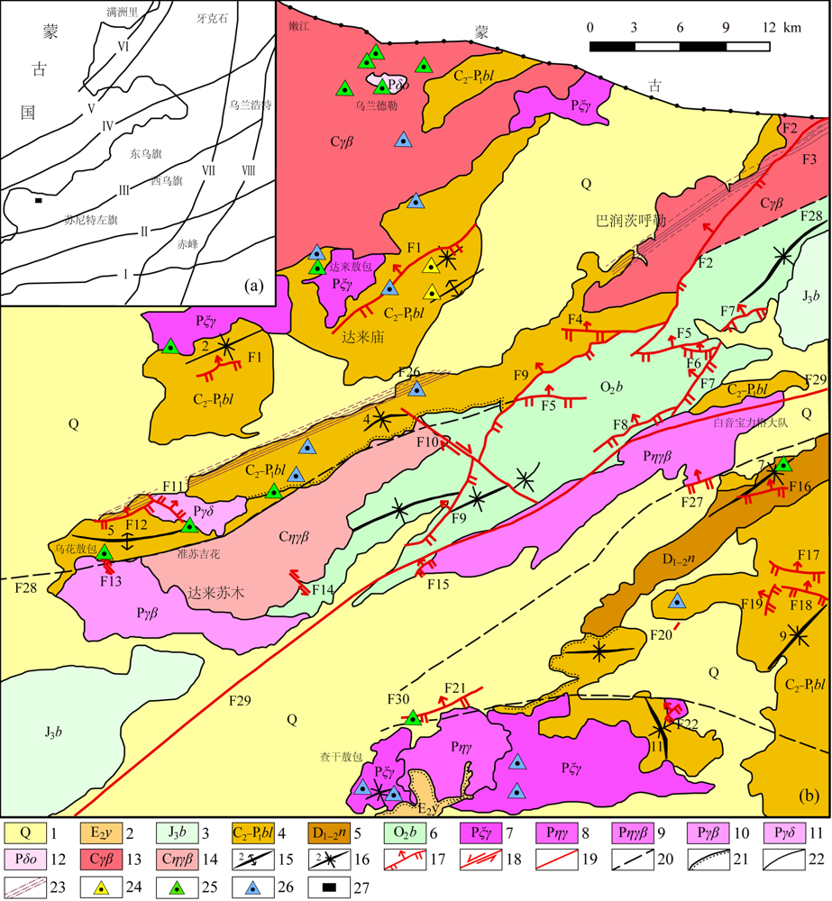
熊双才, 夏庆霖, 姚春亮, 等. 内蒙古新达来草原覆盖区钼铜多金属成矿预测[J]. 地质学刊, 2015, 39(3):422-430.
|
| [5] |
邵积东, 王守光, 赵文涛, 等. 内蒙古中部地区重要成矿区带成矿地质特征及找矿潜力分析[J]. 西部资源, 2008(1):59-61.
|
| [6] |
任纪舜, 陈廷愚, 牛宝贵. 中国东部及邻区大陆岩石圈的构造演化与成矿[M]. 北京: 科学出版社, 1990.
|
| [7] |
XIAO W J, WINDLEY B F, HAO J, et al. Accretion leading to collision and the Permian Solonker suture, Inner Mongolia, China: termination of the central Asian orogenic belt[J]. Tectonic, 2003, 22(6):1069-1088.
|
| [8] |
赵鹏大. “三联式”资源定量预测与评价: 数字找矿理论与实践探讨[J]. 地球科学: 中国地质大学学报, 2002, 27(5):482-489.
|
| [9] |
刘翼飞, 聂凤军, 江思宏, 等. 内蒙古苏尼特左旗准苏吉花钼矿床成岩成矿年代学及其地质意义[J]. 矿床地质, 2012, 31(1):119-128.
|
| [10] |
成秋明, 夏庆霖. 覆盖区矿产综合预测思路与实践[J]. 矿物学报, 2011(增刊):755-756.
|
| [11] |
成秋明. 覆盖区矿产综合预测思路与方法[J]. 地球科学, 2012, 37(6):1109-1125.
|
| [12] |
BREIMAN L. Random forest[J]. Machine Learning, 2001, 45:5-32.
DOI
URL
|
| [13] |
BREIMAN L. Bagging predictors[J]. Machine Learning, 1996, 24(2):123-140.
|
| [14] |
BREIMAN L, FRIEDMAN J H, OLSHEN R A, et al. Classification and Regression trees[J]. Biometrics, 1984, 40(3):358.
|
| [15] |
陈进, 毛先成, 刘占坤, 等. 基于随机森林算法的大尹格庄金矿床三维成矿预测[J]. 大地构造与成矿学, 2020, 44(2):231-241.
|
| [16] |
柯元楚, 史忠奎, 李培军, 等. 基于Hyperion高光谱数据和随机森林方法的岩性分类与分析[J]. 岩石学报, 2018, 34(7):2181-2188.
|
| [17] |
FORBES A D. Classification-algorithm evaluation: five performance measures based on confusion matrices[J]. Journal of Clinical Monitoring, 1995, 11(3):189-206.
DOI
URL
|
| [18] |
CARLETTA J. Assessing agreement on classification tasks: the kappa statistic[J]. Computational Linguistics, 1996, 22(2):249-254.
|
| [19] |
METZ C E. Basic principles of ROC analysis[J]. Seminars in Nuclear Medicine, 1978, 8(4):283-298.
DOI
URL
|
| [20] |
WANG Z Y, YIN Z, CAERS J, et al. A Monte Carlo-based framework for risk-return analysis in mineral prospectivity mapping[J]. Geoscience Frontiers, 2020, 11(6):2297-2308.
DOI
URL
|
| [21] |
CARRANZA E J M, LABORTE A G. Random forest predictive modeling of mineral prospectivity with small number of prospects and data with missing values in Abra (Philippines)[J]. Computers & Geosciences, 2015, 74:60-70.
DOI
URL
|
| [22] |
CHAWLA N V, BOWYER K W, HALL L O, et al. SMOTE: synthetic minority over-sampling technique[J]. Journal of Artificial Intelligence Research, 2002, 16(1):321-357.
DOI
URL
|
| [23] |
HARIHARAN S, TIRODKAR S, PORWAL A, et al. Random forest-based prospectivity modelling of Greenfield Terrains using sparse deposit data: an example from the Tanami Region, Western Australia[J]. Natural Resources Research, 2017, 26(4):489-507.
DOI
URL
|
| [24] |
LI T, XIA Q, ZHAO M, et al. Prospectivity mapping for Tungsten polymetallic mineral resources, Nanling Metallogenic Belt, South China: use of random forest algorithm from a perspective of data imbalance[J]. Natural Resources Research, 2020, 29(1):203-227.
DOI
URL
|
| [25] |
FILZMOSER P, HRON K, REIMANN C. Principal component analysis for compositional data with outliers[J]. Environmetrics, 2010, 20(6):621-632.
DOI
URL
|
| [26] |
CHENG Q M, XU Y G, GRUNSKY E. Integrated spatial and spectrum method for geochemical anomaly separation[J]. Natural Resources Research, 2000, 9(1):43-52.
DOI
URL
|
| [27] |
CHENG Q M, AGTERBERG F P, BALLANTYNE S B. The separation of geochemical anomalies from background by fractal methods[J]. Journal of Geochemical Exploration, 1994, 51(2):109-130.
DOI
URL
|
| [28] |
ZUO R G, WANG Z Y. Effects of random negative training samples on mineral prospectivity mapping[J]. Natural Resources Research, 2020, 29(6):3443-3455.
DOI
URL
|
 ), ZHAO Mengyu1, WANG Xiaochen1, LENG Shuai1, LI Tongfei2, XIONG Shuangcai3