Earth Science Frontiers ›› 2020, Vol. 27 ›› Issue (3): 269-280.DOI: 10.13745/j.esf.sf.2020.3.1
Previous Articles Next Articles
WANG Di1,2,3( ), WANG Xinwei2,3, MAO Xiang2,3, WU Minghui2,3, LIU Huiying2,3, ZHANG Xuan2,3, WANG Tinghao2,3
Received:2019-10-11
Revised:2020-01-02
Online:2020-05-20
Published:2020-05-20
CLC Number:
WANG Di, WANG Xinwei, MAO Xiang, WU Minghui, LIU Huiying, ZHANG Xuan, WANG Tinghao. Characteristics of geothermal geology of the Wucheng uplift geothermal field[J]. Earth Science Frontiers, 2020, 27(3): 269-280.

Fig.1 Geological map of sub-outcrop (a) and tectonic zoning map (b) in the Wucheng uplift

Fig.2 Comprehensive stratigraphic column and reservoir-caprock assemblage in the study area

Fig.3 Geotectonic evolution profile for the Wucheng uplift

Fig.4 Relationship between formation temperature and geothermal well depth for the Wucheng uplift geothermal field

Fig.5 Geological map showing floor depths and well distribution of sandstone thermal reservoir in the Wucheng uplift geothermal field
| 地热井名称 | 井深/m | 出口水温/℃ | 涌水量/(m3·h-1) | 储厚比/% | 孔隙度/% | 渗透率/mD | 储层有效厚度/m | 取水层段/m | 热储层位 |
|---|---|---|---|---|---|---|---|---|---|
| 丽景名城1井 | 1 578 | 54 | 81 | 75.7 | 34.5 | 1 261 | 167.4 | 1 318~1 539 | Ng |
| 森林公园1井 | 1 562.5 | 52 | 79 | 73.8 | 35.4 | 761.1 | 207.3 | 1 268~1 549 | Ng |
| 州海名城1井 | 1 500 | 52 | 123 | 75.8 | 34 | 785.5 | 159.2 | 1 098~1 308 | Ng |
| 运河丽景1井 | 1 610 | 52 | 83 | 64.8 | 29.7 | 523.2 | 190 | 1 304~1 597 | Ng |
| 富邦花园2井 | 2 800 | 54 | 35 | 22.36 | 5.74 | 3.01 | 138.2 | 2 137~2 800 | O |
| 南湖现代城1井 | 3 150 | 84 | 75 | 32.5 | 11.05 | 14.65 | 301.1 | 2 195~3 112 | O |
| 丽景名居1井 | 3 300 | 85 | 80 | 41.6 | 1.47 | 2.71 | 213.7 | 2 751~3 300 | O |
| 信誉家园2井 | 3 130 | 82 | 98 | 21.2 | 6.33 | 1.78 | 131.5 | 2 316~2 936.4 | O |
Table 1 Statistics of typical geothermal boreholes in the Wucheng uplift geothermal field
| 地热井名称 | 井深/m | 出口水温/℃ | 涌水量/(m3·h-1) | 储厚比/% | 孔隙度/% | 渗透率/mD | 储层有效厚度/m | 取水层段/m | 热储层位 |
|---|---|---|---|---|---|---|---|---|---|
| 丽景名城1井 | 1 578 | 54 | 81 | 75.7 | 34.5 | 1 261 | 167.4 | 1 318~1 539 | Ng |
| 森林公园1井 | 1 562.5 | 52 | 79 | 73.8 | 35.4 | 761.1 | 207.3 | 1 268~1 549 | Ng |
| 州海名城1井 | 1 500 | 52 | 123 | 75.8 | 34 | 785.5 | 159.2 | 1 098~1 308 | Ng |
| 运河丽景1井 | 1 610 | 52 | 83 | 64.8 | 29.7 | 523.2 | 190 | 1 304~1 597 | Ng |
| 富邦花园2井 | 2 800 | 54 | 35 | 22.36 | 5.74 | 3.01 | 138.2 | 2 137~2 800 | O |
| 南湖现代城1井 | 3 150 | 84 | 75 | 32.5 | 11.05 | 14.65 | 301.1 | 2 195~3 112 | O |
| 丽景名居1井 | 3 300 | 85 | 80 | 41.6 | 1.47 | 2.71 | 213.7 | 2 751~3 300 | O |
| 信誉家园2井 | 3 130 | 82 | 98 | 21.2 | 6.33 | 1.78 | 131.5 | 2 316~2 936.4 | O |

Fig.6 Stratum correlation of sandstone thermal reservoir in the Wucheng uplift geothermal field

Fig.7 Roof depth map and well 1ocation distribution map of the Ordovician karst thermal reservoir in the Wucheng uplift geothermal field

Fig.8 Stratum correlation of karst thermal reservoir in the Wucheng uplift geothermal field
| 井号 | pH | T/℃ | ρB/(mg·L-1) | δ2H/‰ | δ18O/‰ | 水化学 类型 | ||||||||
|---|---|---|---|---|---|---|---|---|---|---|---|---|---|---|
| TDS | Na+ | K+ | Mg2+ | Ca2+ | Cl- | S | HC | SiO2 | ||||||
| 丽景明居1井 | 6.32 | 90 | 17 312 | 4 803.35 | 194.53 | 155.4 | 1 043.73 | 9 129.81 | 668.43 | 207.69 | 34.89 | -68.86 | -8.2 | Cl-Na |
| 丽景明居2井 | 7.18 | 54 | 4 697 | 1 682.36 | 21.18 | 35.55 | 136.45 | 2 425.84 | 388.92 | 209.80 | 24.55 | -72.58 | -9.9 | Cl-Na |
| 丽景明居3井 | 7.41 | 53 | 4 559 | 1 631.81 | 17.83 | 33.66 | 128.44 | 2 349.98 | 379.47 | 214.40 | 26.98 | Cl-Na | ||
| 富邦花园1井 | 6.71 | 74 | 8 403 | 2 558.17 | 81.51 | 70.36 | 429.53 | 4 383.67 | 22.31 | 239.68 | 28.67 | -73.6 | -9.4 | Cl-Na |
| 富邦花园2井 | 7.66 | 47 | 2 260 | 755.25 | 6.42 | 10.84 | 34.03 | 791.73 | 213.45 | 444.21 | 23.74 | Cl-Na | ||
| 南湖现代城1井 | 7.44 | 53 | 4 757 | 1 686.62 | 23.15 | 31.07 | 137.91 | 2 429.08 | 389.97 | 223.88 | 27.49 | Cl-Na | ||
| 运河丽景1井 | 7.34 | 54 | 4 557 | 1 606.34 | 22.83 | 27.46 | 123.3 | 2 305.86 | 374.2 | 233.45 | 25.54 | -74.64 | -9.8 | Cl-Na |
Table 2 Chemical and isotopic compositions of groundwater in the study area
| 井号 | pH | T/℃ | ρB/(mg·L-1) | δ2H/‰ | δ18O/‰ | 水化学 类型 | ||||||||
|---|---|---|---|---|---|---|---|---|---|---|---|---|---|---|
| TDS | Na+ | K+ | Mg2+ | Ca2+ | Cl- | S | HC | SiO2 | ||||||
| 丽景明居1井 | 6.32 | 90 | 17 312 | 4 803.35 | 194.53 | 155.4 | 1 043.73 | 9 129.81 | 668.43 | 207.69 | 34.89 | -68.86 | -8.2 | Cl-Na |
| 丽景明居2井 | 7.18 | 54 | 4 697 | 1 682.36 | 21.18 | 35.55 | 136.45 | 2 425.84 | 388.92 | 209.80 | 24.55 | -72.58 | -9.9 | Cl-Na |
| 丽景明居3井 | 7.41 | 53 | 4 559 | 1 631.81 | 17.83 | 33.66 | 128.44 | 2 349.98 | 379.47 | 214.40 | 26.98 | Cl-Na | ||
| 富邦花园1井 | 6.71 | 74 | 8 403 | 2 558.17 | 81.51 | 70.36 | 429.53 | 4 383.67 | 22.31 | 239.68 | 28.67 | -73.6 | -9.4 | Cl-Na |
| 富邦花园2井 | 7.66 | 47 | 2 260 | 755.25 | 6.42 | 10.84 | 34.03 | 791.73 | 213.45 | 444.21 | 23.74 | Cl-Na | ||
| 南湖现代城1井 | 7.44 | 53 | 4 757 | 1 686.62 | 23.15 | 31.07 | 137.91 | 2 429.08 | 389.97 | 223.88 | 27.49 | Cl-Na | ||
| 运河丽景1井 | 7.34 | 54 | 4 557 | 1 606.34 | 22.83 | 27.46 | 123.3 | 2 305.86 | 374.2 | 233.45 | 25.54 | -74.64 | -9.8 | Cl-Na |

Fig.9 Piper diagram for groundwater samples from the Wucheng uplift geothermal field
| 地名 | 矿化度/(g·L-1) | 水型 |
|---|---|---|
| 大成[ | 6.1 | Cl·SO4-Na |
| 青县[ | 5.9 | Cl·SO4-Na |
| 无极[ | 6.38 | Cl·HCO3-Na |
| 阜城[ | 6.3 | Cl-Na |
| 衡水[ | 7.7 | Cl-Na |
| 故城 | 11.9 | Cl-Na |
| 新河[ | 10.7 | Cl-Na |
| 南宫[ | 11.8 | Cl-Na |
Table 3 Statistics of total dissoloved solid
| 地名 | 矿化度/(g·L-1) | 水型 |
|---|---|---|
| 大成[ | 6.1 | Cl·SO4-Na |
| 青县[ | 5.9 | Cl·SO4-Na |
| 无极[ | 6.38 | Cl·HCO3-Na |
| 阜城[ | 6.3 | Cl-Na |
| 衡水[ | 7.7 | Cl-Na |
| 故城 | 11.9 | Cl-Na |
| 新河[ | 10.7 | Cl-Na |
| 南宫[ | 11.8 | Cl-Na |
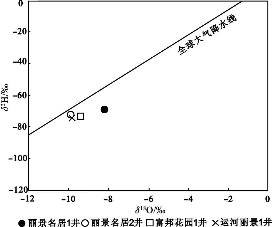
Fig.10 Water stable isotopic compositions for groundwater samples of from the Wucheng uplift geothermal field
| 编号 | 14C活度/ PMC | 表观 年龄/a | Tamers模型 校正年龄/a | Pearson模型 校正年龄/a | 热储 类型 |
|---|---|---|---|---|---|
| 丽景明居2井 | <0.44 | 44 856 | 40 012 | 37 264 | O |
| 富邦花园1井 | 0.70 | 41 018 | 37 387 | 27 608 | O |
| 运河丽景1井 | 3.60 | 27 480 | 22 395 | 20 312 | Ng |
Table 4 The 14C age correction model age of the Wucheng uplift geothermal field
| 编号 | 14C活度/ PMC | 表观 年龄/a | Tamers模型 校正年龄/a | Pearson模型 校正年龄/a | 热储 类型 |
|---|---|---|---|---|---|
| 丽景明居2井 | <0.44 | 44 856 | 40 012 | 37 264 | O |
| 富邦花园1井 | 0.70 | 41 018 | 37 387 | 27 608 | O |
| 运河丽景1井 | 3.60 | 27 480 | 22 395 | 20 312 | Ng |

Fig.11 Na-K-Mg ternary diagram (a) and solubility diagram of SiO2 (b) of water samples from the Wucheng uplift geothermal field
| 井号 | T/℃ | TNa-K/℃ | TK-Mg/℃ | T石英/℃ | 平均热储 温度/℃ |
|---|---|---|---|---|---|
| 丽景明居1井 | 90 | 107.67 | 54.74 | 88.61 | 127.94 |
| 丽景明居2井 | 54 | 169.16 | 71.20 | 71.33 | 189.71 |
| 富邦花园1井 | 74 | 154.97 | 65.76 | 77.55 | 161.58 |
| 富邦花园2井 | 47 | 90.67 | 48.51 | 70.01 | 94.68 |
| 南湖现代城1井 | 53 | 111.63 | 56.41 | 75.84 | 123.76 |
| 运河丽景1井 | 54 | 113.25 | 56.92 | 72.89 | 121.55 |
Table 5 Temperature of geothermal reservoir by temperature scale method in the study area
| 井号 | T/℃ | TNa-K/℃ | TK-Mg/℃ | T石英/℃ | 平均热储 温度/℃ |
|---|---|---|---|---|---|
| 丽景明居1井 | 90 | 107.67 | 54.74 | 88.61 | 127.94 |
| 丽景明居2井 | 54 | 169.16 | 71.20 | 71.33 | 189.71 |
| 富邦花园1井 | 74 | 154.97 | 65.76 | 77.55 | 161.58 |
| 富邦花园2井 | 47 | 90.67 | 48.51 | 70.01 | 94.68 |
| 南湖现代城1井 | 53 | 111.63 | 56.41 | 75.84 | 123.76 |
| 运河丽景1井 | 54 | 113.25 | 56.92 | 72.89 | 121.55 |

Fig.12 Sketch map illustrating a genetic model of the Wucheng uplift geothermal field
| 层位 | 面积/km2 | 平均有效 厚度/m | 平均 温度/℃ | 平均 孔隙度/% | 地热资源 总量/GJ | 折合 标煤/t | 可采地热 资源量/GJ | 可采资源量 折合标煤/t |
|---|---|---|---|---|---|---|---|---|
| 新近系馆陶组 | 840.56 | 181 | 52 | 33.4 | 1.64×10¹⁰ | 5.6×10⁸ | 4.1×10⁹ | 1.4×10⁸ |
| 奥陶系 | 944.22 | 196 | 83 | 6.15 | 3.22×10¹⁰ | 11×108 | 4.83×10⁹ | 1.65×10⁸ |
Table 6 Summary of evaluation parameters and calculation results for the geothermal resources in the Wucheng uplift geothermal filed
| 层位 | 面积/km2 | 平均有效 厚度/m | 平均 温度/℃ | 平均 孔隙度/% | 地热资源 总量/GJ | 折合 标煤/t | 可采地热 资源量/GJ | 可采资源量 折合标煤/t |
|---|---|---|---|---|---|---|---|---|
| 新近系馆陶组 | 840.56 | 181 | 52 | 33.4 | 1.64×10¹⁰ | 5.6×10⁸ | 4.1×10⁹ | 1.4×10⁸ |
| 奥陶系 | 944.22 | 196 | 83 | 6.15 | 3.22×10¹⁰ | 11×108 | 4.83×10⁹ | 1.65×10⁸ |
| [1] | 蔺文静, 刘志明, 王婉丽, 等. 中国地热资源及其潜力评估[J]. 中国地质, 2013, 40(1):312-320. |
| [2] | 王贵玲, 张发旺, 刘志明. 国内外地热能开发利用现状及前景分析[J]. 地球学报: 中国地质科学院院报, 2000, 21(2):134-139. |
| [3] |
KOSE R. Geothermal energy potential for power generation in Turkey: a case study in Simav, Kutahya[J]. Renewable and Sustainable Energy Reviews, 2007, 11(3):497-511.
DOI URL |
| [4] | 蔺文静, 刘志明, 马峰, 等. 我国陆区干热岩资源潜力估算[J]. 地球学报, 2012, 33(5):807-811. |
| [5] | 郭世炎, 李小军. 河北保定容城凸起地热田储层属性与资源潜力[J]. 地质科学, 2013, 48(3):922-931. |
| [6] | 李攻科, 王卫星, 杨峰田, 等. 河北遵化汤泉地热田成因模式[J]. 现代地质, 2015, 29(1):220-228. |
| [7] | 吕灿. 牛驼镇地热田地热系统特征及其成因机制研究[J]. 地下水, 2018, 40(3):28-30. |
| [8] | 刘现川, 刘仕娟, 杨风良. 高阳县地热资源评价[J]. 煤炭技术, 2018, 37(4):44-46. |
| [9] | 中原油田石油地质志编辑委员会. 中国石油地质志(卷七): 中原·南阳油田(上册)[M]. 北京: 石油工业出版社, 1993: 298-299. |
| [10] | 胡君春, 郭纯青. 石家庄凹陷地热资源研究[J]. 地质与资源, 2008, 17(4):297-301. |
| [11] | 钱会, 马致远. 水文地球化学[M]. 北京: 地质出版社, 2005: 124-133. |
| [12] | PANG Z. PH dependent isotope variations in arc-type geothermal fluids: new insights into their origins[J]. Journal of Geochemical Eploration, 2006, 89:306-308. |
| [13] | 杨峰田. 深层地热资源成因与潜力评价: 以苏北盆地为列[D]. 北京: 中国科学院研究生院, 2011: 1-19. |
| [14] |
WANG S F, PANG Z H, LIU J R, et al. Origin and evolution characteristics of geothermal water in the Niutuozhen geothermal field, North China plain, North China[J]. Journal of Earth Science, 2013, 24(6):891-902.
DOI URL |
| [15] |
MINISSALE A, CORTI G, TASSI F. Geothermal potential and origin of natural thermal fluids in the northern lake Abaya area, Main Ethiopian rift, East Africa[J]. Journal of Volcanology and Geothermal Research, 2017, 336:1-18.
DOI URL |
| [16] |
CRAIG H. Standard for reporting concentration of deuterium and oxygen-18 in natural water[J]. Science, 1961, 133:1833-1834.
DOI URL |
| [17] |
YILMAZ E E, ÖZGÜR N. Hydrogeological, hydro-geochemical and isotope geochemical features of geothermal waters in Tekkehamam and environs, western Anatolia, Turkey[J]. Procedia Earth and Planetary Science, 2017, 17:177-180.
DOI URL |
| [18] |
TAMERS M A. Validity of radiocarbon dates on groundwater[J]. Geophysical Survey, 1975, 2(2):217-239.
DOI URL |
| [19] | 克拉克, 弗里茨. 水文地质学中的环境同位素[M]. 张慧, 张新基, 译. 郑州: 黄河水利出版社, 2005. |
| [20] |
GILLON M, BARBECOT F, GIBERT E, et al. Open to closed system transition traced through the TDIC isotopic signature at the aquifer recharge stage, implications for groundwater14C dating[J]. Geochimica et Cosmochimica Acta, 2009, 73:6488-6501.
DOI URL |
| [21] | CLARK I D, FRITZ P. Environmental isotopes in hydrogeology[M]. New York: Lewis Publishers, 1997: 112-244. |
| [22] | 刘存富. 地下水14C年龄校正方法: 以河北平原为例[J]. 水文地质工程地质, 1990(5):4-8. |
| [23] | ARNÓRSSON S. Isotopic and chemical techniques in geothermal exploration, development and use[M]. Vienna, Austria: International Atomic Energy Agency, 2000: 152-199. |
| [24] | 孙红丽, 马峰, 蔺文静, 等. 西藏高温地热田地球化学特征及地热温标应用[J]. 地质科技情报, 2015, 34(3):171-177. |
| [25] |
PIRLO M C. Hydrogeochemistry and geothermometry of thermal groundwaters from the Birdsville Track Ridge, Great Artesian Basin, South Australia[J]. Geothermics, 2004, 33(6):743-774.
DOI URL |
| [26] | 于湲. 北京城区地热田地下热水的水化学及同位素研究[D]. 北京: 中国地质大学(北京), 2006. |
| [27] | 王莹, 周训, 于湲, 等. 应用地热温标估算地下热储温度[J]. 现代地质, 2007, 21(4):605-612. |
| [28] |
GIGGENBACH W F. Geothermal solute equilibria: derivation of Na-K-Mg-Ca geoindicators[J]. Geochimica et Cosmochimica Acta, 1988, 52(12):2749-2765.
DOI URL |
| [29] |
FOURNIER R O. Chemical geothermometers and mixing models for geothermal systems[J]. Geothermics, 1977, 5:41-50.
DOI URL |
| [30] | 刘忠凯, 赵忠义, 李郡, 等. 衡水市浅层地热能评价[J]. 节能, 2010, 6:51-53. |
| [31] | 周训, 金晓媚, 梁四海, 等. 地下水科学专论[M]. 北京: 地质出版社, 2017. |
| [32] | 王留忠, 胡有福. 东濮凹陷北部与临清坳陷东部地温场特征与油气关系[C]//中国地球物理学会第八届学术年会论文集. 北京: 地震出版社, 1992: 311. |
| [33] | 李攻科. 河北汤泉地热田成因与资源潜力评价[D]. 北京: 中国地质大学(北京), 2014. |
| [34] | 张保建, 高宗军, 张凤禹, 等. 华北盆地地下热水的水动力条件及水化学响应[J]. 地学前缘, 2015, 22(6):217-226. |
| [35] | 中华人民共和国地质矿产部. 地热资源评价方法: DZ 40—85[S]. |
| [1] | WANG Guiling, MA Feng, ZHANG Wei, ZHU Xi, YU Mingxiao, ZHANG Hanxiong, LUO Cheng. Dominant heat transfer mechanism in buried-hill reservoirs in North China: A case study in Xiong’an new area [J]. Earth Science Frontiers, 2024, 31(6): 52-66. |
| [2] | WANG Guiling, LIN Wenjing. The thermal status of China’s land areas and heat-control factors [J]. Earth Science Frontiers, 2024, 31(6): 1-18. |
| [3] | . Geologic evaluation and targets optimization of shale gas. [J]. Earth Science Frontiers, 2012, 19(5): 332-338. |
| Viewed | ||||||
|
Full text |
|
|||||
|
Abstract |
|
|||||