地学前缘 ›› 2024, Vol. 31 ›› Issue (6): 173-195.DOI: 10.13745/j.esf.sf.2024.7.17
刘玲霞1,2( ), 路睿3,4, 谢文苹3,4, 刘博3,4, 王亚茹1,2, 姚海慧5, 蔺文静1,2,*()
收稿日期:2024-02-25
修回日期:2024-05-24
出版日期:2024-11-25
发布日期:2024-11-25
通信作者:
*蔺文静(1978—),男,研究员,博士生导师,主要从事地热地质、地热资源评价方面的研究工作。E-mail: linwenjing@mail.cgs.gov.cn
作者简介:刘玲霞(1981—),女,正高级工程师,主要从事水文地质及地热地质方面的研究工作。E-mail: liulingxia@mail.cgs.gov.cn
基金资助:
LIU Lingxia1,2(), LU Rui3,4, XIE Wenping3,4, LIU Bo3,4, WANG Yaru1,2, YAO Haihui5, LIN Wenjing1,2,*()
Received:2024-02-25
Revised:2024-05-24
Online:2024-11-25
Published:2024-11-25
摘要:
青藏高原是我国地热活动最强烈的地区,传统观点认为其东北部地区处于相对稳定的地块,地热赋存条件一般。青海省位于青藏高原东北部,地热资源种类齐全,以往研究主要集中在勘查程度较高或单个温泉温度较高的区域,而区内大部分地区研究程度较低,地热资源整体分布特征和热源机制不清。本文依据主要控热活动断裂和温泉集中区将温泉自东北向西南划分为11个区,利用水文地球化学和同位素分析手段对温泉的分布特征和成因进行了综合研究。结果表明,温泉补给来源均为其附近大气降水和冰雪融水。温泉水化学特征与热储的地层岩性相关,花岗岩热储中地热水阳离子以Na+为主,阴离子以
中图分类号:
刘玲霞, 路睿, 谢文苹, 刘博, 王亚茹, 姚海慧, 蔺文静. 青藏高原东北部温泉分布及水文地球化学特征[J]. 地学前缘, 2024, 31(6): 173-195.
LIU Lingxia, LU Rui, XIE Wenping, LIU Bo, WANG Yaru, YAO Haihui, LIN Wenjing. Distribution and hydrogeochemical characteristics of hot springs in northeastern Tibetan Plateau[J]. Earth Science Frontiers, 2024, 31(6): 173-195.

图1 青海省地质简图及主要温泉点分布图(据文献[29])
Fig.1 Simplified geologic map of Qinghai Province and location of hot springs. Modified after [29].
 |
表1 温泉水化学组分及氢氧同位素组成
Table 1 Chemical and hydrogen oxygen isotopic compositions of hot spring water samples
| |
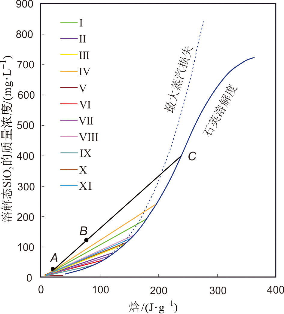
图2 研究区温泉水硅—焓模型图(引自文献[41])
Fig.2 Silicon-enthalpy model diagram for hot spring water in the study area. Adapted from [41].

图3 温泉水化学piper图
Fig.3 Piper trilinear diagram for the studied water samples

图5 温泉水化学吉布斯(Gibbs)图
Fig.5 Gibbs diagrams for the studied water samples
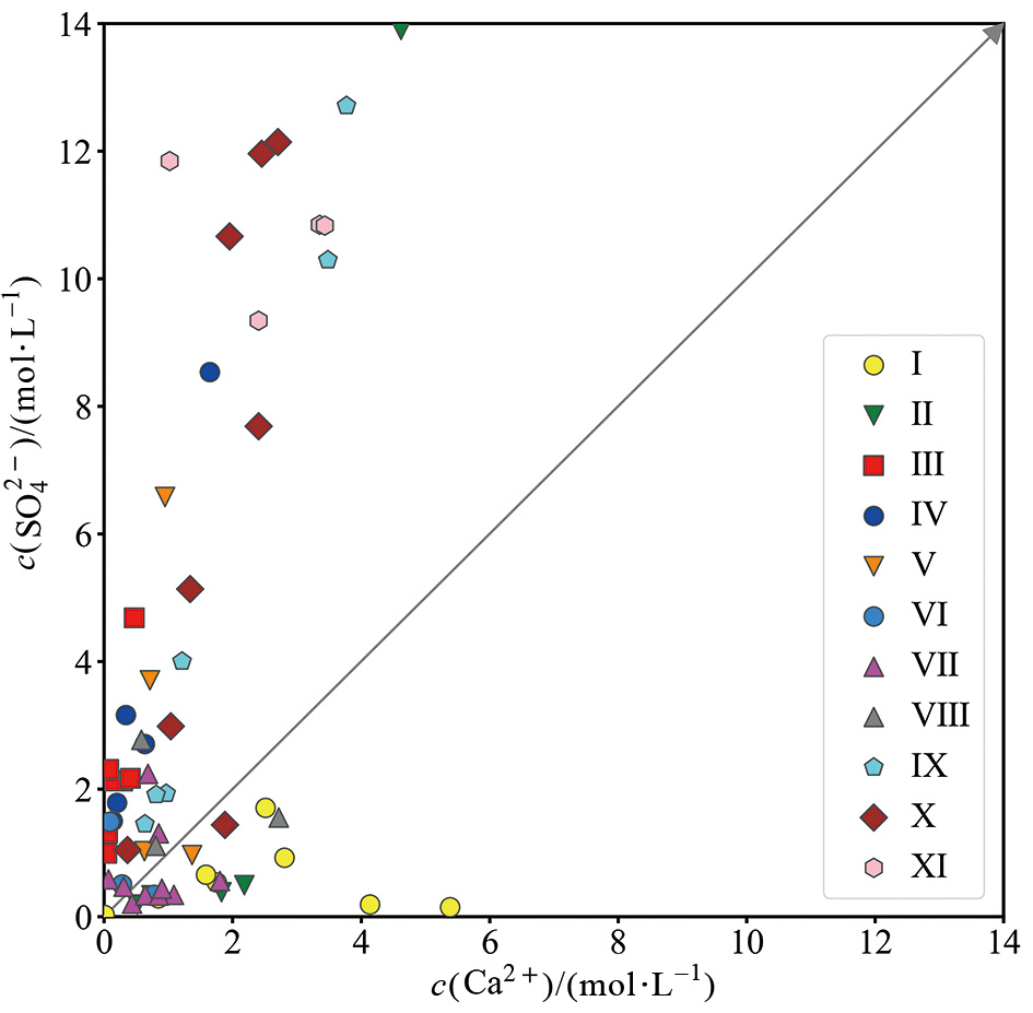
图4 温泉水中Ca2+与 SO 4 2 -的关系图
Fig.4 Relationship between Ca2+ and SO 4 2 - in hot spring water in the study area
| 分区 | 特征系数 | 特征系数平均值 | ||||
|---|---|---|---|---|---|---|
| γ(Na+)/γ(Cl) | γ(Cl-)/γ(Ca2+) | γ(Cl-)/γ( | γ(Na+)/γ(Cl-) | γ(Cl-)/γ(Ca2+) | γ(Cl-)/γ( | |
| Ⅰ区 | 1.77~5.88 | 0.04~33.87 | 0.01~0.40 | 3.63 | 4.70 | 0.11 |
| Ⅱ区 | 1.45~5.56 | 0.07~56.47 | 0.01~8.80 | 2.88 | 15.95 | 1.43 |
| Ⅲ区 | 1.10~6.07 | 4.99~136.05 | 0.73~23.32 | 3.20 | 35.12 | 7.82 |
| Ⅳ区 | 0.92~2.44 | 1.56~41.33 | 0.74~21.75 | 1.52 | 18.93 | 9.07 |
| Ⅴ区 | 0.71~1.79 | 0.21~41.12 | 0.05~3.66 | 1.35 | 12.66 | 1.46 |
| Ⅵ区 | 14.42~26.33 | 0.64~13.37 | 0.03~0.06 | 19.04 | 5.12 | 0.04 |
| Ⅶ区 | 1.61~8.04 | 0.03~6.43 | 0.01~0.14 | 4.78 | 1.33 | 0.07 |
| Ⅷ区 | 9.01~22.24 | 0.21~0.85 | 0.03~0.09 | 12.63 | 0.60 | 0.06 |
| Ⅸ区 | 1.00~16.84 | 0.01~0.52 | 0.02~0.12 | 5.91 | 0.18 | 0.07 |
| Ⅹ区 | 1.11~6.21 | 0.97~21.91 | 0.13~5.03 | 2.21 | 10.80 | 2.26 |
| Ⅺ区 | 5.91~13.89 | 0.23~1.43 | 0.16~0.26 | 8.20 | 0.61 | 0.19 |
表2 研究区温泉水离子特征系数表
Table 2 Ion characteristic coefficients for hot spring water in the study area
| 分区 | 特征系数 | 特征系数平均值 | ||||
|---|---|---|---|---|---|---|
| γ(Na+)/γ(Cl) | γ(Cl-)/γ(Ca2+) | γ(Cl-)/γ( | γ(Na+)/γ(Cl-) | γ(Cl-)/γ(Ca2+) | γ(Cl-)/γ( | |
| Ⅰ区 | 1.77~5.88 | 0.04~33.87 | 0.01~0.40 | 3.63 | 4.70 | 0.11 |
| Ⅱ区 | 1.45~5.56 | 0.07~56.47 | 0.01~8.80 | 2.88 | 15.95 | 1.43 |
| Ⅲ区 | 1.10~6.07 | 4.99~136.05 | 0.73~23.32 | 3.20 | 35.12 | 7.82 |
| Ⅳ区 | 0.92~2.44 | 1.56~41.33 | 0.74~21.75 | 1.52 | 18.93 | 9.07 |
| Ⅴ区 | 0.71~1.79 | 0.21~41.12 | 0.05~3.66 | 1.35 | 12.66 | 1.46 |
| Ⅵ区 | 14.42~26.33 | 0.64~13.37 | 0.03~0.06 | 19.04 | 5.12 | 0.04 |
| Ⅶ区 | 1.61~8.04 | 0.03~6.43 | 0.01~0.14 | 4.78 | 1.33 | 0.07 |
| Ⅷ区 | 9.01~22.24 | 0.21~0.85 | 0.03~0.09 | 12.63 | 0.60 | 0.06 |
| Ⅸ区 | 1.00~16.84 | 0.01~0.52 | 0.02~0.12 | 5.91 | 0.18 | 0.07 |
| Ⅹ区 | 1.11~6.21 | 0.97~21.91 | 0.13~5.03 | 2.21 | 10.80 | 2.26 |
| Ⅺ区 | 5.91~13.89 | 0.23~1.43 | 0.16~0.26 | 8.20 | 0.61 | 0.19 |
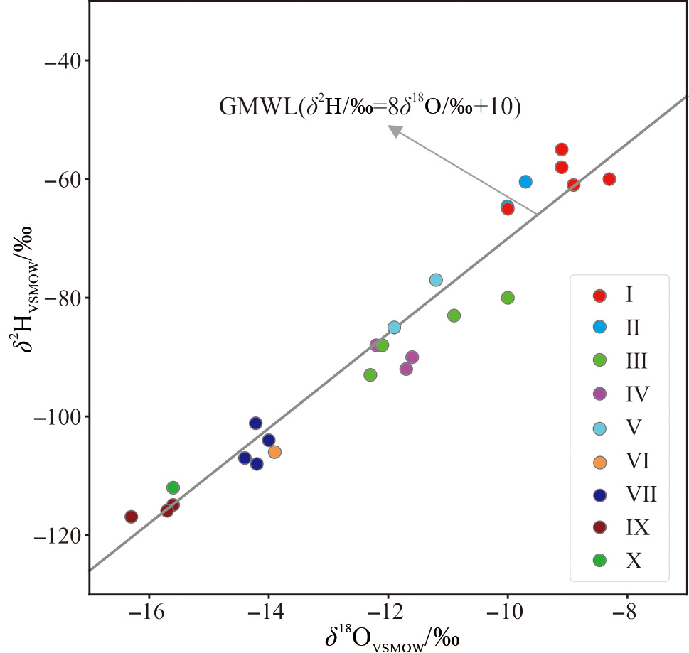
图6 青海省温泉水样δD-δ18O关系图
Fig.6 δD vs. δ18O plots for the studied water samples
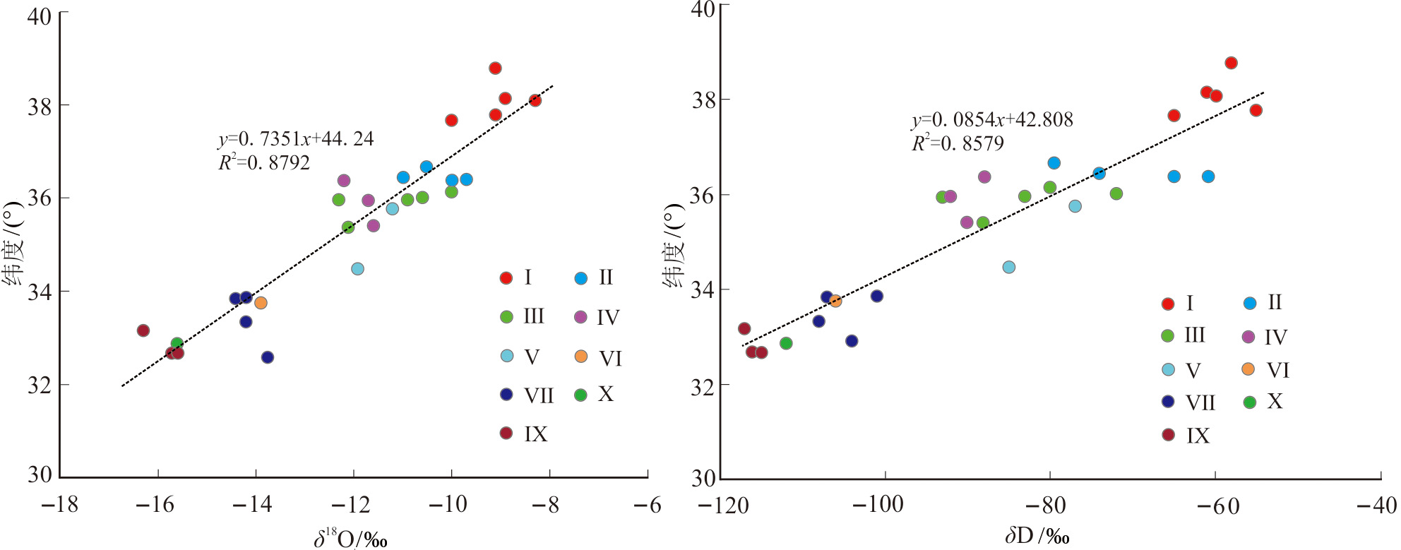
图7 青海省温泉水样δD、δ18O与纬度关系图
Fig.7 δD and δ18O vs. latitude relationship of hot spring water samples from the Qinghai
| 温泉分区及编号 | 温泉口高程/m | δ18O/‰ | 补给区高程/m | 温泉分区及编号 | 温泉口高程/m | δ18O/‰ | 补给区高程/m | ||
|---|---|---|---|---|---|---|---|---|---|
| Ⅰ区 | 11 | 3 771 | -9.10 | 4 271 | Ⅳ区 | 22 | 4 282 | -11.70 | 5 525 |
| 13 | 3 776 | -8.30 | 4 009 | 23 | 3 945 | -11.60 | 5 155 | ||
| 14 | 3 630 | -10.00 | 4 430 | 35 | 3 790 | -12.20 | 5 200 | ||
| 15 | 3 824 | -8.90 | 4 257 | Ⅴ区 | 37 | 3 969 | -11.20 | 5 046 | |
| 16 | 3 460 | -9.10 | 3 960 | 89 | 3 860 | -11.90 | 5 170 | ||
| Ⅱ区 | 1 | 2 281 | -10.50 | 3 928 | Ⅵ区 | 82 | 4 076 | -13.9 | 5 343 |
| 4 | 2 891 | -9.70 | 4 271 | Ⅶ区 | 63 | 4 226 | -14.40 | 5 659 | |
| 5 | 2 980 | -10.00 | 4 460 | 64 | 4 331 | -14.20 | 5 698 | ||
| 8 | 2 317 | -10.99 | 4 127 | 54 | 3 997 | -14.00 | 5 297 | ||
| Ⅲ区 | 26 | 2 436 | -10.00 | 3 297 | 55 | 4 219 | -14.20 | 5 586 | |
| 27 | 2 492 | -10.90 | 3 603 | Ⅹ区 | 60 | 4 281 | -15.60 | 5 809 | |
| 28 | 3 235 | -12.30 | 4 735 | Ⅸ区 | 78 | 3 978 | -15.60 | 5 506 | |
| 32 | 2 890 | -12.1 | 4 334 | 61 | 4 548 | -16.30 | 6 270 | ||
| 33 | 3 726 | -10.6 | 4 754 | 79 | 3 940 | -15.70 | 5 496 | ||
表3 温泉补给高程
Table 3 Hot spring water recharge elevation in each district
| 温泉分区及编号 | 温泉口高程/m | δ18O/‰ | 补给区高程/m | 温泉分区及编号 | 温泉口高程/m | δ18O/‰ | 补给区高程/m | ||
|---|---|---|---|---|---|---|---|---|---|
| Ⅰ区 | 11 | 3 771 | -9.10 | 4 271 | Ⅳ区 | 22 | 4 282 | -11.70 | 5 525 |
| 13 | 3 776 | -8.30 | 4 009 | 23 | 3 945 | -11.60 | 5 155 | ||
| 14 | 3 630 | -10.00 | 4 430 | 35 | 3 790 | -12.20 | 5 200 | ||
| 15 | 3 824 | -8.90 | 4 257 | Ⅴ区 | 37 | 3 969 | -11.20 | 5 046 | |
| 16 | 3 460 | -9.10 | 3 960 | 89 | 3 860 | -11.90 | 5 170 | ||
| Ⅱ区 | 1 | 2 281 | -10.50 | 3 928 | Ⅵ区 | 82 | 4 076 | -13.9 | 5 343 |
| 4 | 2 891 | -9.70 | 4 271 | Ⅶ区 | 63 | 4 226 | -14.40 | 5 659 | |
| 5 | 2 980 | -10.00 | 4 460 | 64 | 4 331 | -14.20 | 5 698 | ||
| 8 | 2 317 | -10.99 | 4 127 | 54 | 3 997 | -14.00 | 5 297 | ||
| Ⅲ区 | 26 | 2 436 | -10.00 | 3 297 | 55 | 4 219 | -14.20 | 5 586 | |
| 27 | 2 492 | -10.90 | 3 603 | Ⅹ区 | 60 | 4 281 | -15.60 | 5 809 | |
| 28 | 3 235 | -12.30 | 4 735 | Ⅸ区 | 78 | 3 978 | -15.60 | 5 506 | |
| 32 | 2 890 | -12.1 | 4 334 | 61 | 4 548 | -16.30 | 6 270 | ||
| 33 | 3 726 | -10.6 | 4 754 | 79 | 3 940 | -15.70 | 5 496 | ||
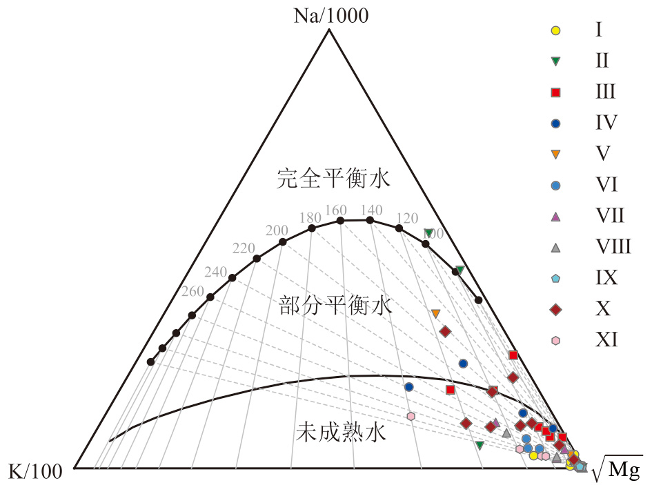
图8 青海省温泉水样品Na-K-Mg三角图(Na、K和Mg质量浓度单位mg/L)
Fig.8 Na-K-Mg ternary diagram for the studied water samples
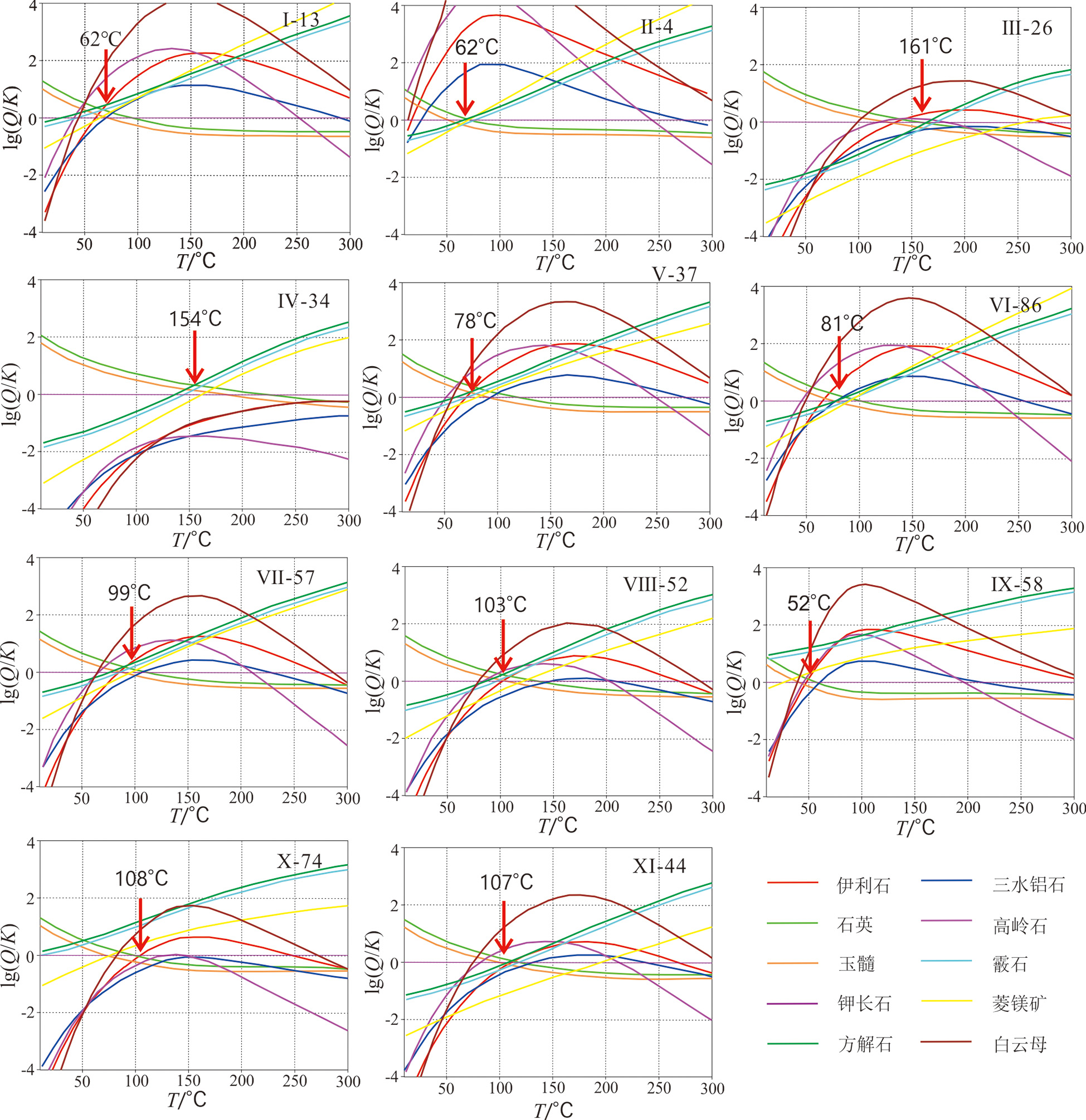
图9 各区典型温泉矿物SI—T图
Fig.9 Typical SI—T curves for various minerals in selected water samples from each district
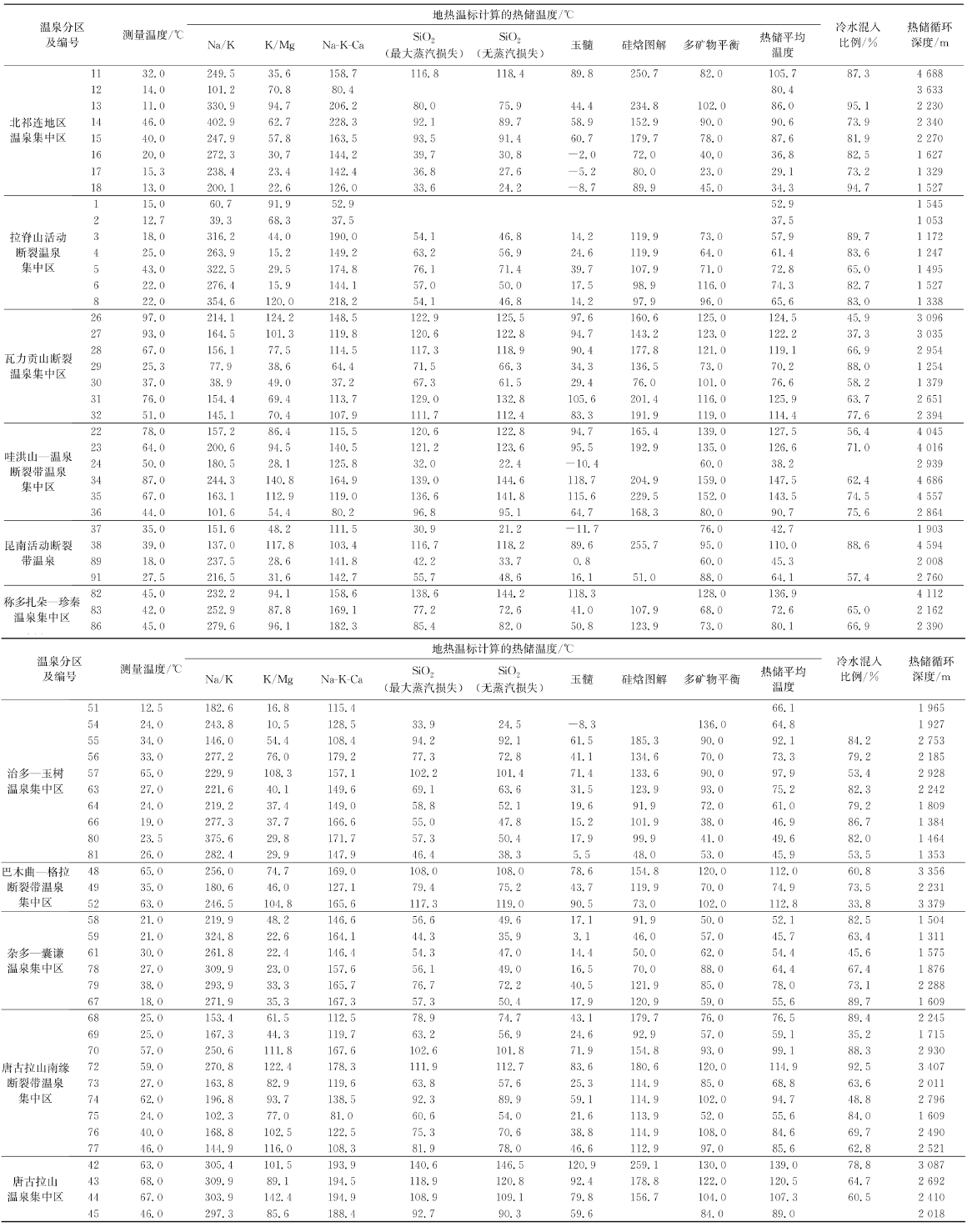 |
表4 热储温度及循环深度估算结果
Table 4 Geothermal temperature and circulation depth estimation results
| |
| 温泉编号 | 冷水混入比例/% | 温泉温度/℃ | 温泉编号 | 冷水混入比例/% | 温泉温度/℃ | 温泉编号 | 冷水混入比例/% | 温泉温度/℃ |
|---|---|---|---|---|---|---|---|---|
| Ⅰ区 | Ⅳ区 | Ⅷ区 | ||||||
| 11 | 87.3 | 32 | 22 | 56.4 | 78 | 48 | 60.8 | 65 |
| 12 | 14 | 23 | 71.0 | 64 | 49 | 73.5 | 35 | |
| 13 | 95.1 | 11 | 24 | 50 | 52 | 33.8 | 63 | |
| 14 | 73.9 | 46 | 34 | 62.4 | 87 | Ⅸ区 | ||
| 15 | 81.9 | 40 | 35 | 74.5 | 67 | 58 | 82.5 | 21 |
| 16 | 82.5 | 20 | 36 | 75.6 | 44 | 59 | 63.4 | 21 |
| 17 | 73.2 | 15.3 | Ⅴ区 | 61 | 45.6 | 30 | ||
| 18 | 94.7 | 13 | 37 | 35 | 78 | 67.4 | 27 | |
| Ⅱ区 | 38 | 88.6 | 39 | 79 | 73.1 | 38 | ||
| 1 | 15 | 89 | 18 | 67 | 89.7 | 18 | ||
| 2 | 12.7 | 91 | 57.4 | 27.5 | Ⅹ区 | |||
| 3 | 18 | Ⅵ区 | 68 | 89.4 | 25 | |||
| 4 | 83.6 | 25 | 82 | 45 | 69 | 35.2 | 25 | |
| 5 | 65.0 | 43 | 83 | 65.0 | 42 | 70 | 88.3 | 57 |
| 6 | 82.7 | 22 | 86 | 66.9 | 45 | 72 | 92.5 | 59 |
| 8 | 83.0 | 22 | Ⅶ区 | 73 | 63.6 | 27 | ||
| Ⅲ区 | 51 | 12.5 | 74 | 48.8 | 62 | |||
| 26 | 45.9 | 54 | 24 | 75 | 84.0 | 24 | ||
| 27 | 37.3 | 98 | 55 | 84.2 | 34 | 76 | 69.7 | 40 |
| 28 | 66.9 | 67 | 56 | 79.2 | 33 | 77 | 62.8 | 46 |
| 29 | 88.0 | 25.3 | 57 | 53.4 | 65 | Ⅺ区 | ||
| 30 | 58.2 | 37 | 63 | 82.3 | 27 | 42 | 78.8 | 63 |
| 31 | 63.7 | 76 | 64 | 79.2 | 24 | 43 | 64.7 | 68 |
| 32 | 77.6 | 51 | 66 | 86.7 | 19 | 44 | 60.5 | 67 |
| 80 | 82.0 | 23.5 | 45 | 46 | ||||
| 81 | 53.5 | 26 | ||||||
表5 研究区温泉冷水混入比例
Table 5 Mixing proportion of cold water in hot springs in the study area
| 温泉编号 | 冷水混入比例/% | 温泉温度/℃ | 温泉编号 | 冷水混入比例/% | 温泉温度/℃ | 温泉编号 | 冷水混入比例/% | 温泉温度/℃ |
|---|---|---|---|---|---|---|---|---|
| Ⅰ区 | Ⅳ区 | Ⅷ区 | ||||||
| 11 | 87.3 | 32 | 22 | 56.4 | 78 | 48 | 60.8 | 65 |
| 12 | 14 | 23 | 71.0 | 64 | 49 | 73.5 | 35 | |
| 13 | 95.1 | 11 | 24 | 50 | 52 | 33.8 | 63 | |
| 14 | 73.9 | 46 | 34 | 62.4 | 87 | Ⅸ区 | ||
| 15 | 81.9 | 40 | 35 | 74.5 | 67 | 58 | 82.5 | 21 |
| 16 | 82.5 | 20 | 36 | 75.6 | 44 | 59 | 63.4 | 21 |
| 17 | 73.2 | 15.3 | Ⅴ区 | 61 | 45.6 | 30 | ||
| 18 | 94.7 | 13 | 37 | 35 | 78 | 67.4 | 27 | |
| Ⅱ区 | 38 | 88.6 | 39 | 79 | 73.1 | 38 | ||
| 1 | 15 | 89 | 18 | 67 | 89.7 | 18 | ||
| 2 | 12.7 | 91 | 57.4 | 27.5 | Ⅹ区 | |||
| 3 | 18 | Ⅵ区 | 68 | 89.4 | 25 | |||
| 4 | 83.6 | 25 | 82 | 45 | 69 | 35.2 | 25 | |
| 5 | 65.0 | 43 | 83 | 65.0 | 42 | 70 | 88.3 | 57 |
| 6 | 82.7 | 22 | 86 | 66.9 | 45 | 72 | 92.5 | 59 |
| 8 | 83.0 | 22 | Ⅶ区 | 73 | 63.6 | 27 | ||
| Ⅲ区 | 51 | 12.5 | 74 | 48.8 | 62 | |||
| 26 | 45.9 | 54 | 24 | 75 | 84.0 | 24 | ||
| 27 | 37.3 | 98 | 55 | 84.2 | 34 | 76 | 69.7 | 40 |
| 28 | 66.9 | 67 | 56 | 79.2 | 33 | 77 | 62.8 | 46 |
| 29 | 88.0 | 25.3 | 57 | 53.4 | 65 | Ⅺ区 | ||
| 30 | 58.2 | 37 | 63 | 82.3 | 27 | 42 | 78.8 | 63 |
| 31 | 63.7 | 76 | 64 | 79.2 | 24 | 43 | 64.7 | 68 |
| 32 | 77.6 | 51 | 66 | 86.7 | 19 | 44 | 60.5 | 67 |
| 80 | 82.0 | 23.5 | 45 | 46 | ||||
| 81 | 53.5 | 26 | ||||||
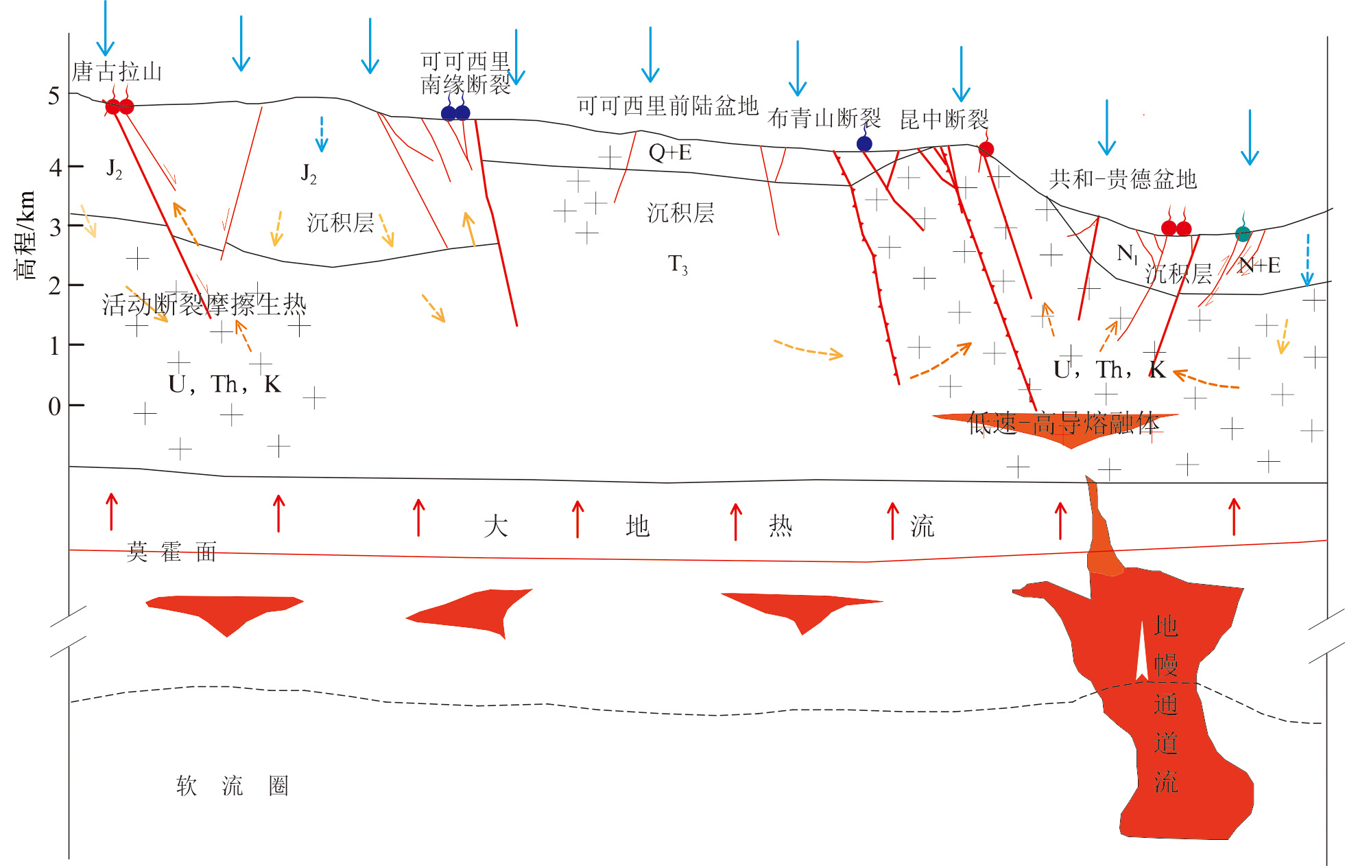
图10 青海省温泉热源机制简图
Fig.10 Heat sources for hot springs in Qinghai
| [1] | 汪集旸, 胡圣标, 庞忠和, 等. 中国大陆干热岩地热资源潜力评估[J]. 科技导报, 2012, 30(32): 25-31. |
| [2] | NICHOLSON K, Geothermal fluid[M]. Berlin, Heidelberg: Springer-Verlag, 1993. |
| [3] | YE T, HUANG Q H, CHEN X B, et al. Magma chamber and crustal channel flow structures in the Tengchong volcano area from 3-D MT inversion at the intracontinental block boundary southeast of the Tibetan Plateau[J]. Journal of Geophysical Research: Solid Earth, 2018, 123(12): 112-126. |
| [4] | ZHANG M L, LIU W, GUAN L F, et al. First estimates of hydrothermal helium fluxes in continental collision settings: insights from the southeast Tibetan Plateau margin[J]. Geophysical Research Letters, 2022, 49(11): e98228. |
| [5] | YU X L, WEI Z F, WANG G, et al. Hot spring gas geochemical characteristics and geological implications of the northern Yadong-gulu Rift in the Tibetan Plateau[J]. Frontiers in Earth Science, 2022, 10: 863559. |
| [6] | YOKOYAMA T, NAKAI S, WAKITA H. Helium and carbon isotopic compositions of hot spring gases in the Tibetan Plateau[J]. Journal of Volcanology and Geothermal Research, 1999, 88(1/2): 99-107. |
| [7] | TIAN J, PANG Z H, LIAO D W, et al. Fluid geochemistry and its implications on the role of deep faults in the genesis of high temperature systems in the eastern edge of the Qinghai Tibet Plateau[J]. Applied Geochemistry, 2021, 131: 105036. |
| [8] | ZHOU X C, LIU L, CHEN Z, et al. Gas geochemistry of the hot spring in the Litang fault zone, Southeast Tibetan Plateau[J]. Applied Geochemistry, 2017, 79: 17-26. |
| [9] | 王贵玲, 蔺文静. 我国主要水热型地热系统形成机制与成因模式[J]. 地质学报, 2020, 94(7): 1923-1937. |
| [10] | 王贵玲. 中国地热志: 华南卷[M]. 北京: 科学出版社, 2018. |
| [11] |
张保建, 雷玉德, 赵振, 等. 共和盆地干热岩形成的地球动力学过程与成因机制[J]. 地学前缘, 2023, 30(5): 384-401.
DOI |
| [12] | LIN W J, WANG G L, GAN H N, et al. Heat source model for Enhanced Geothermal Systems (EGS) under different geological conditions in China[J]. Gondwana Research, 2023, 122: 243-259. |
| [13] | 王瑞娟. 青海省共和盆地恰卜恰地热区地下热水地球化学特征与资源评价[D]. 西安: 长安大学, 2009. |
| [14] | 李永革. 青海省共和盆地恰卜恰地区地下热水水文地球化学特征及成因分析[D]. 抚州: 东华理工大学, 2016. |
| [15] | 唐显春, 王贵玲, 马岩, 等. 青海共和盆地地热资源热源机制与聚热模式[J]. 地质学报, 2020, 94(7): 2052-2065. |
| [16] | 郎旭娟. 贵德盆地热结构及地热成因机制[D]. 北京: 中国地质科学院, 2016. |
| [17] | 戴蔓. 青海贵德地区地热水水文地球化学特征及形成演化规律[D]. 北京: 中国地质大学(北京), 2020. |
| [18] | 王万平, 汪生斌, 侯利朋, 等. 青海贵德盆地地下热水资源的分布特征[J]. 中国锰业, 2017, 35(2): 7-9. |
| [19] | 李小林, 吴国禄, 雷玉德, 等. 青海省贵德扎仓寺地热成因机理及开发利用建议[J]. 吉林大学学报(地球科学版), 2016, 46(1): 220-229. |
| [20] | 周玲. 青海省贵德县扎仓沟地热田成因机理及开采潜力研究[D]. 长春: 吉林大学, 2020. |
| [21] | 李乐乐. 青海贵德盆地地热资源赋存规律及成因模式研究[D]. 抚州: 东华理工大学, 2016. |
| [22] | 郎旭娟, 张发旺, 王贵玲. 贵德盆地热结构及地热成因机制[J]. 地球学报, 2017, 38(增刊1): 43-46. |
| [23] | JIANG Z J, XU T F, MALLANTS D, et al. Numerical modelling of stable isotope (2H and 18O) transport in a hydro-geothermal system: model development and implementation to the Guide Basin, China[J]. Journal of Hydrology, 2019, 569: 93-105. |
| [24] | 赵振, 秦光雄, 罗银飞, 等. 西宁盆地地热水特征及回灌结垢风险[J]. 水文地质工程地质, 2021, 48(5): 193-204. |
| [25] | 石维栋, 张森琦, 周金元, 等. 西宁盆地北西缘地下热水分布特征[J]. 中国地质, 2006, 33(5): 1131-1136. |
| [26] | 孙恺. 西宁盆地地下热水循环机制与资源评价[D]. 西安: 西北大学, 2015. |
| [27] | LIU L X, QI S H, ZHANG Y B, et al. Isotopic and hydrogeochemical characteristics and genesis of warm springs in the Jiangcang Basin, Qinghai, China[J]. Frontiers in Earth Science, 2022, 10: 905852. |
| [28] | 刘玲霞, 杜煜, 祁士华. 青藏高原东北缘江仓盆地温泉水文地球化学特征及意义[J/OL]. 现代地质, 2023. https://doi.org/10.19657/j.geoscience.1000-8527.2023.017. |
| [29] | 蔺文静, 路睿, 刘玲霞, 等. 青海省地热资源分布规律及成因机理研究成果报告[R]. 石家庄: 中国地质科学院水文地质环境地质研究所, 2024. |
| [30] | 吴向农, 古风宝. 青海省区域地质志[M]. 北京: 地质出版社, 1991. |
| [31] | 周保. 青海省活动断裂展布特征及其对公路工程的危害[D]. 西安: 长安大学, 2007. |
| [32] | 杨绍, 罗银飞, 赵振, 等. 青海省地热资源现状评价与区划报告[R]. 西宁: 青海省环境地质勘查局, 2015. |
| [33] | 张长华, 马天林, 宋友贵, 等. 青藏高原的构造体系特征与高原的形成演化[M]. 北京: 地质出版社, 1990. |
| [34] | FOURNIER R O, POTTER R W. Magenesium correction to the Na-K-Ca chemical geothermo-meter[J]. Geochimica et cosmochimica acta, 1979, 43(9): 1543-1550. |
| [35] | GIGGENBACH W F. Geothermal solute equilibria. Derivation of Na-K-Mg-Ca geoindicators[J]. Geochimica et Cosmochimica Acta, 1988, 52(12): 2749-2765. |
| [36] | FOURNIER R O, TRUESDELL A H. An empirical Na-K-Ca geothermometer for natural waters[J]. Geochimica et Cosmochimica Acta, 1973, 37(5): 1255-1275. |
| [37] | 赵庆生. 地热温标在川西地热资源研究中的初步应用[J]. 成都科技大学学报, 1988, 20(1): 45-50, 44. |
| [38] | FOURNIER R O. Chemical geothermometers and mixingmodels for geothermal systems[J]. Geothermics, 1977, 5(1/2/3/4): 41-50. |
| [39] | Kelly, Walton R. Groundwater geochemistry and isotopes[J]. Groundwater, 2015, 53(6): 832-833. |
| [40] | TOLE M P, ÁRMANNSSON H, PANG Z H, et al. Fluid/mineral equilibrium calculations for geothermal fluids and chemical geothermometry[J]. Geothermics, 1993, 22(1): 17-37. |
| [41] | 朱炳球, 朱立新, 史长义, 等. 地热田地球化学勘查[M]. 北京: 地质出版社, 1992. |
| [42] | 李学礼, 孙占学, 刘金辉, 等. 水文地球化学[M]. 北京: 原子能出版社, 1982. |
| [43] |
马月花, 唐保春, 苏生云, 等. 青海共和盆地地热流体地球化学特征及热储水-岩相互作用过程[J]. 地学前缘, 2020, 27(1): 123-133.
DOI |
| [44] | 王大纯, 张人权, 史毅虹, 等. 水文地质学基础[M]. 北京: 地质出版社, 1986. |
| [45] | 沈照理, 朱宛华, 钟佐燊, 等. 水文地球化学基础[M]. 北京: 地质出版社, 1993. |
| [46] | MONDAL N C, SINGH V P, SINGH V S, et al. Determining the interaction between groundwater and saline water through groundwater major ions chemistry[J]. Journal of Hydrology, 2010, 388(1/2): 100-111. |
| [47] | 郝永河. 阿克苏地区地下水化学特征及其形成原因分析[D]. 阿拉尔: 塔里木大学, 2010. |
| [48] | 秦莉红, 石晓今, 于彦, 等. 天津市蓟县系雾迷山组地热流体地球化学特征[J]. 地质找矿论丛, 2019, 34(1): 150-154. |
| [49] | 陈道公, 支霞臣, 杨海涛. 地球化学[M]. 合肥: 中国科学技术大学出版社, 1994. |
| [50] | 田立德, 姚檀栋, 孙维贞, 等. 青藏高原南北降水中δD和δ18O关系及水汽循环[J]. 中国科学D辑: 地球科学, 2001, 31(3): 214-220. |
| [51] | CLARK I D, FRITZ P. Environmental isotopes in hydrogeology[M]. Boca Raton, FL: CRC Press/Lewis Publishers, 1997. |
| [52] | SUN Z X, LI X L, SHI W J. Isotopic hydrogeochemistry of mid-low temperature geothermal water in Jiangxi province[J]. Journal of East China Geological Institute, 1992, 15(3): 243-248. |
| [53] | LIU L X, GUO Q H, ZHANG X B, et al. Geochemistry of geothermal waters from the Gonghe region, northwestern China: implications for identification of the heat source[J]. Environmental Earth Sciences, 2016, 75(8): 1-13. |
| [54] | 李永革, 蔺文静, 邢林啸, 等. 青海省恰卜恰地区深部热储温度估算[D]. 地质与资源, 2021, 30(4): 479-511. |
| [55] | 章新平, 施雅风, 姚檀栋. 青藏高原东北部降水中δ18O的变化特征[J]. 中国科学: B辑, 1995, 25(5): 540-547. |
| [56] | 史杰, 乃尉华, 李明, 等. 新疆曲曼高温地热田水文地球化学特征研究[J]. 水文地质工程地质, 2018, 45(3): 165-172. |
| [57] | 张展适, 孙占学, 王素娟. 固定铝方法成功恢复汤湖温泉热储平衡温度及其研究意义[J]. 华东地质学院学报, 2003, 26(4): 306-310. |
| [58] | PANG Z H, REED M. Theoretical chemical thermometry on geothermal waters: problems and methods[J]. Geochimica et Cosmochimica Acta, 1998, 62(6): 1083-1091. |
| [59] | SHESTAKOVA A, GUSEVA N, KOPYLOVA Y, et al. Geothermometry and isotope geochemistry of CO2-rich thermal waters in Choygan, East Tuva, Russia[J]. Water, 2018, 10(6): 729. |
| [60] | 路凤香, 桑隆康. 岩石学[M]. 北京: 地质出版社, 2002. |
| [61] | 李广岑, 劳雄. 唐古拉山温泉地区地质特征: 青藏高原地质文集1[M]. 北京: 地质出版社, 1982. |
| [62] | 杨绍康, 沈春强, 陈建敏, 等. 青海省祁连县城区地热资源勘查报告[R]. 西宁: 青海省环境地质勘查局, 2018. |
| [63] | 王万平, 袁有靖, 王万平, 等. 青海省门源盆地地下热水资源调查评价报告[R]. 西宁: 青海省环境地质勘查局, 2019. |
| [64] | 李成英, 张盛生, 李斌民, 等. 平安县地热资源调查评价报告[R]. 西宁: 青海省水文地质工程地质环境地质调查院, 2018. |
| [65] | 赵振, 李铜邦, 赵振, 等. 青海省同仁盆地地下热水资源勘查报告[R]. 西宁: 青海省环境地质勘查局, 2021. |
| [66] | 郭守鋆, 郑天翔, 陈佰辉, 等. 青海省兴海县温泉地区地热资源调查评价报告[R]. 西宁: 青海省水文地质工程地质环境地质调查院, 2016. |
| [67] | 刘毅, 张国强, 肖善虎, 等. 玛沁地区地热资源调查评价报告[R]. 西宁: 青海省环境地质勘查局, 2018. |
| [68] | 张盛生, 张磊, 马清华, 等. 青海省玉树县结古地区地下热水资源勘查成果报告[R]. 西宁: 青海省水文地质工程地质勘察院, 2016. |
| [69] | 陈彦交. 青海囊谦高浓度盐泉水化学及硼同位素地球化学特征研究[D]. 西宁: 中国科学院研究生院(青海盐湖研究所), 2016. |
| [70] | 郭守鋆, 张盛生, 张磊, 等. 青海省玉树县结古地区地下热水资源勘查工作总结[R]. 西宁: 青海省水文地质工程地质勘察院, 2015. |
| [71] | 刘峰, 闫晓雪, 刘玲霞, 等. 全国大地热流值测量与靶区优选[R]. 石家庄: 中国地质科学院水文地质环境地质研究所, 2022. |
| [72] | 邵维晔, 王云, 李其林, 等. 红河断裂带温泉水文地球化学及构造活动特征研究[J]. 矿物岩石地球化学通报, 2022, 41(3): 612-624. |
| [73] | 朱贵麟, 张林友, 李旭峰, 等. 青海共和盆地地下水演化特征及成因机制[J]. 人民长江, 2020, 51(增刊2): 28-31, 67. |
| [74] | 路畅, 李营, 陈志, 等. 华北断陷盆地中北部地热水地球化学特征及成因初探[J]. 矿物岩石地球化学通报, 2018, 37(4): 663-673, 795. |
| [75] | 李德发, 伦志强, 郭家玉, 等. 青海省地质志[M]. 北京: 地质出版社, 1991. |
| [76] | 蔺文静, 王贵玲, 甘浩男. 华南陆缘火成岩区差异性地壳热结构及地热意义[J]. 地质学报, 2024, 98(2): 544-557. |
| [77] | 张文佑, 马福臣, 李阴槐, 等. 中国及邻区海陆大地构造基本轮廓[M]. 北京: 石油工业出版社 |
| [78] | WANG G L, GAN H N, LIN W J, et al. Hydrothermal systems characterized by crustal thermally-dominated structures of southeastern China[J]. Acta Geologica Sinica (English Edition), 2023, 97(4): 1003-1013. |
| [79] | 薛建球, 甘斌, 李百祥, 等. 青海共和—贵德盆地增强型地热系统(干热岩)地质—地球物理特征[J]. 物探与化探, 2013, 37(1): 35-41. |
| [80] | 徐刚, 伍坤宇, 王鹏, 等. 藏北温泉盆地地热田水文地球化学特征研究[J]. 中国岩溶, 2020, 39(3): 299-310. |
| [81] | 王贵玲, 蔺文静, 刘峰, 等. 地热系统深部热能聚敛理论及勘查实践[J]. 地质学报, 2023, 97(3): 639-660. |
| [82] | 沈显杰, 张文仁, 杨淑贞, 等. 青藏高原南北地体壳幔热结构差异的大地热流证据[J]. 中国地质科学院学报, 1990, 21: 203-214. |
| [83] | LIN W J, WANG G L, ZHANG S S, et al. Heat aggregation mechanisms of hot dry rocks resources in the Gonghe Basin, northeastern Tibetan Plateau[J]. Acta Geologica Sinica (English Edition), 2021, 95(6): 1793-1804. |
| [84] |
张超, 胡圣标, 宋荣彩, 等. 共和盆地干热岩地热资源的成因机制: 来自岩石放射性生热率的约束[J]. 地球物理学报, 2020, 63(7): 2697-2709.
DOI |
| [85] | 王贵玲, 刘峰, 蔺文静, 等. 我国陆区地壳生热率分布与壳幔热流特征研究[J]. 地球物理学报, 2023, 66(12): 5041-5056. |
| [86] | MCLAREN S, SANDIFORD M, HAND M, et al. The hot southern continent: heat flow and heat production in Australian Proterozoic terranes[J] Geological Society of Australia Special Publication, 2003, 22: 151-161. |
| [87] | 李林果, 李百祥. 从青海共和—贵德盆地与山地地温场特征探讨热源机制和地热系统[J]. 物探与化探, 2017, 41(1): 29-34. |
| [88] |
WANG Q, HAWKESWORTH C J, WYMAN D, et al. Pliocene-Quaternary crustal melting in central and northern Tibet and insights into crustal flow[J]. Nature Communications, 2016, 7: 11888.
DOI PMID |
| [1] | 郭华明, 尹嘉鸿, 严松, 刘超. 陕北靖边高铬地下水中硝酸根分布及来源[J]. 地学前缘, 2024, 31(1): 384-399. |
| [2] | 栗兵帅, 颜茂都, 张伟林. 柴北缘早新生代旋转变形特征及其构造意义[J]. 地学前缘, 2022, 29(4): 249-264. |
| [3] | 周长松, 邹胜章, 冯启言, 朱丹尼, 李军, 王佳, 谢浩, 邓日欣. 岩溶关键带水文地球化学研究进展[J]. 地学前缘, 2022, 29(3): 37-50. |
| [4] | 王广才, 王焰新, 刘菲, 郭华明. 基于文献计量学分析水文地球化学研究进展及趋势[J]. 地学前缘, 2022, 29(3): 25-36. |
| [5] | 刘海燕, 刘茂涵, 张卫民, 孙占学, 王振, 吴通航, 郭华明. 华北平原高氟地下水中稀土元素分布和分异特征[J]. 地学前缘, 2022, 29(3): 129-144. |
| [6] | 刘妍君, 马腾, 杜尧, 刘锐. 黏性土弱透水层压实作用:原理、技术及其水文地质意义[J]. 地学前缘, 2021, 28(5): 59-67. |
| [7] | 马月花, 唐保春, 苏生云, 张盛生, 李成英. 青海共和盆地地热流体地球化学特征及热储水-岩相互作用过程[J]. 地学前缘, 2020, 27(1): 123-133. |
| [8] | 吴初,武雄,张艳帅,岩岩,朱鹏程. 秦皇岛牛心山高氟地下水分布特征及成因[J]. 地学前缘, 2018, 25(4): 307-315. |
| [9] | 毛若愚, 郭华明, 贾永锋, 姜玉肖, 曹永生, 赵威光, 王振. 内蒙古河套盆地含氟地下水分布特点及成因[J]. 地学前缘, 2016, 23(2): 260-268. |
| [10] | 张保建,然高宗军,然张凤禹. 华北盆地地下热水的水动力条件及水化学响应[J]. 地学前缘, 2015, 22(6): 217-226. |
| [11] | 郭清海,王焰新. 典型新生代断陷盆地内孔隙地下水地球化学过程及其模拟:以山西太原盆地为例[J]. 地学前缘, 2014, 21(4): 83-90. |
| [12] | 郭华明, 倪萍, 贾永锋, 郭琦, 姜玉肖. 原生高砷地下水的类型、化学特征及成因[J]. 地学前缘, 2014, 21(4): 1-12. |
| [13] | 李德威. 东昆仑、玉树、汶川地震的发生规律和形成机理:兼论大陆地震成因与预测[J]. 地学前缘, 2010, 17(5): 179-192. |
| [14] | 王世杰 罗维均 刘秀明 谢兴能 周运超 黎廷宇 刘启明. 贵州七星洞系统中水文地球化学特征对滴水δ13CDIC的影响及其意义[J]. 地学前缘, 2009, 16(6): 66-76. |
| 阅读次数 | ||||||
|
全文 |
|
|||||
|
摘要 |
|
|||||