地学前缘 ›› 2023, Vol. 30 ›› Issue (5): 216-226.DOI: 10.13745/j.esf.sf.2023.5.22
王子烨1,2( ), 左仁广1,*()
收稿日期:2022-12-20
修回日期:2023-02-14
出版日期:2023-09-25
发布日期:2023-10-20
通信作者:
*左仁广(1981—),男,博士,教授,博士生导师,主要从事数学地质与矿产勘查方面的研究工作。E-mail: zrguang@cug.edu.cn
作者简介:王子烨(1991—),男,博士,副教授,主要从事数学地质与矿产勘查方面的研究工作。E-mail: ziyewang@cug.edu.cn
基金资助:
WANG Ziye1,2(), ZUO Renguang1,*()
Received:2022-12-20
Revised:2023-02-14
Online:2023-09-25
Published:2023-10-20
摘要:
稀有金属在新材料、新能源和信息技术等新兴产业中具有不可替代性,已成为全球争夺的关键战略性矿产资源。喜马拉雅地区广泛发育呈东西向分布的淡色花岗岩带,延绵上千千米,已被证实具有较大的稀有金属找矿潜力,有望成为我国重要的稀有金属成矿带。以往喜马拉雅淡色花岗岩识别主要依靠野外地质填图,然而该地区自然条件恶劣,地质研究工作程度较低,使得圈定的淡色花岗岩空间分布范围具有不确定性,制约了该地区进一步找寻稀有金属矿。本文围绕喜马拉雅淡色花岗岩的识别,探讨了如何利用地球化学、地球物理和遥感等多源数据,基于机器学习技术在区域尺度和矿区尺度上圈定淡色花岗岩的空间分布范围,为该区进一步稀有金属找矿工作提供参考依据。研究发现:(1)区域勘查地球化学、地球物理和遥感数据可从不同的角度为高效识别淡色花岗岩提供有效的信息;(2)多源数据融合技术通过结合同一目标的不同特征,可以吸收各种数据源的优点,实现不同类型数据的优势互补;(3)深度学习较传统的浅层机器学习算法在深层次地学数据挖掘与集成方面具有显著优势,可深入挖掘多源地学数据间的相关信息,提取与淡色花岗岩有关的高级特征,从而提高岩体识别精度。
中图分类号:
王子烨, 左仁广. 基于多源数据融合的喜马拉雅淡色花岗岩识别[J]. 地学前缘, 2023, 30(5): 216-226.
WANG Ziye, ZUO Renguang. Mapping Himalayan leucogranites by machine learning using multi-source data[J]. Earth Science Frontiers, 2023, 30(5): 216-226.

图1 喜马拉雅淡色花岗岩空间分布图(据文献[6])
Fig.1 Distribution map of leucogranites in the Himalayas orogen. Adapted from [6].

图2 基于地球化学数据的喜马拉雅淡色花岗岩识别(据文献[33])
Fig.2 Mapping Himalayan leucogranites using geochemical survey data. Adapted from [33].

图3 基于遥感影像的喜马拉雅淡色花岗岩识别(据文献[36])
Fig.3 Mapping Himalayan leucogranites by ASTER and Sentinel-2 remote sensing. Adapted from [36].

图4 喜马拉雅淡色花岗岩与寒武纪花岗质片麻岩(据文献[39]) a—光谱曲线;b—地球化学分析指标。
Fig.4 Spectral curves derived from ASTER image (a) and chemical composition graphs (b) for Himalayan leucogranites and Cambrian granite gneiss. Adapted from [39].
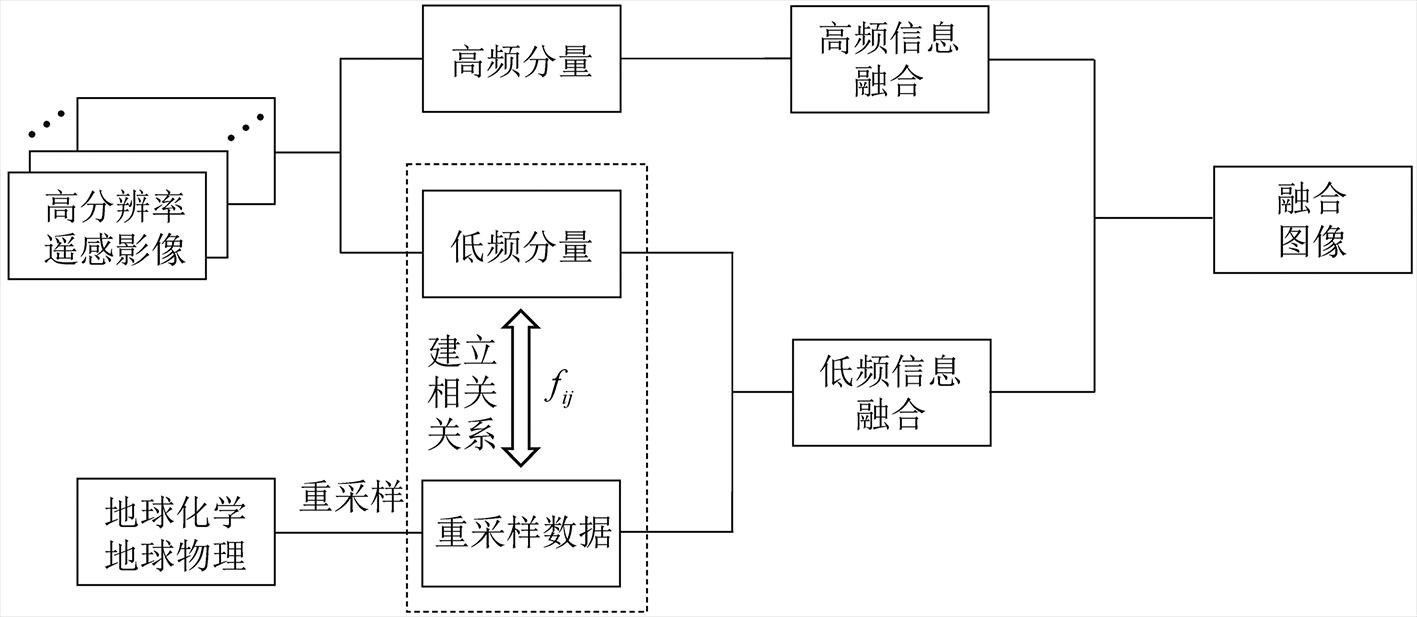
图5 多源地学数据融合技术基本原理(据文献[41])
Fig.5 Flowchart of multi-source geological data fusion. Adapted from [41].

图6 错那洞地球化学和遥感影像数据(据文献[39]) a—错那洞地球化学数据(底图为Fe2O3含量分布图层);b—ASTER遥感影像(由波段3、2、1假彩色合成)。
Fig.6 Fe2O3 concentration layer from grid survey (a) and ASTER false color composite image bands 3, 2, 1 (b) of the Cuonadong dome. Adapted from [39].
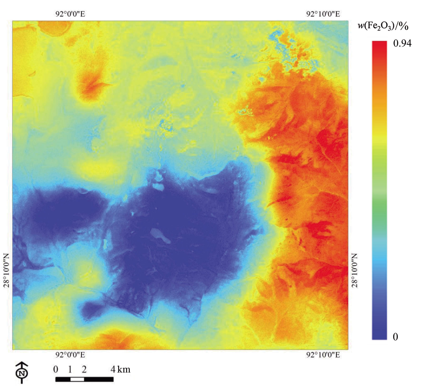
图7 Fe2O3地球化学图层与ASTER遥感影像融合结果(据文献[39])
Fig.7 Composite image combining Fe2O3 concentration layer and ASTER image (spectral bands B1-B9). Adapted from [39].

图8 基于遥感影像融合的错那洞岩性填图(据文献[37]) a—ASTER和Sentinel-2融合影像; b—ASTER影像。
Fig.8 Lithological classification of the Cuonadong dome by remote sensing. (a) Composite image combining ASTER and Sentinel-2 remote sensing images. (b) ASTER image alone (adapted from [37]).

图9 基于随机森林测度学习的错那洞岩性填图(据文献[39])
Fig.9 Lithological classification of the Cuonadong dome using multi-source data combined with random forest metric learning. Adapted from [39].

图10 基于全卷积神经网络的错那洞岩性填图(据文献[45])
Fig.10 Lithological classification of the Cuonadong dome using multi-source data combined with fully convolutional network. Adapted from [45].
| 岩性单元 | ASTER影像+ 随机森林[ | ASTER影像+地球化学数据+ 随机森林[ | ASTER影像+地球化学+航磁数据+ 全卷积神经网络[ |
|---|---|---|---|
| 侏罗系砂岩、板岩 | 97.0% | 98.1% | 99.0% |
| 下古生界大理岩 | 39.7% | 70.0% | 83.0% |
| 三叠系砂岩、板岩 | 51.9% | 91.3% | 95.0% |
| 寒武纪花岗质片麻岩 | 65.6% | 85.5% | 94.0% |
| 古生代黑云母石英片岩 | 54.5% | 80.77% | 92.0% |
| 第四纪地层 | 84.9% | 91.2% | 94.0% |
| 喜马拉雅淡色花岗岩 | 75.3% | 87.8% | 96.0% |
| 总分精度 | 85.75% | 93.16% | 96.0% |
表1 错那洞岩性填图定量评价结果(据文献[37,39,45])
Table 1 Quantitative performance evaluation of three lithological classification methods for each lithological unit of the Cuonadong dome. Adapted from [37,39,45].
| 岩性单元 | ASTER影像+ 随机森林[ | ASTER影像+地球化学数据+ 随机森林[ | ASTER影像+地球化学+航磁数据+ 全卷积神经网络[ |
|---|---|---|---|
| 侏罗系砂岩、板岩 | 97.0% | 98.1% | 99.0% |
| 下古生界大理岩 | 39.7% | 70.0% | 83.0% |
| 三叠系砂岩、板岩 | 51.9% | 91.3% | 95.0% |
| 寒武纪花岗质片麻岩 | 65.6% | 85.5% | 94.0% |
| 古生代黑云母石英片岩 | 54.5% | 80.77% | 92.0% |
| 第四纪地层 | 84.9% | 91.2% | 94.0% |
| 喜马拉雅淡色花岗岩 | 75.3% | 87.8% | 96.0% |
| 总分精度 | 85.75% | 93.16% | 96.0% |
| [1] | 蒋少涌, 温汉捷, 许成, 等. 关键金属元素的多圈层循环与富集机理: 主要科学问题及未来研究方向[J]. 中国科学基金, 2019, 33(2): 112-118. |
| [2] | 翟明国, 吴福元, 胡瑞忠, 等. 战略性关键金属矿产资源: 现状与问题[J]. 中国科学基金, 2019, 33(2): 106-111. |
| [3] | 吴福元, 刘志超, 刘小驰, 等. 喜马拉雅淡色花岗岩[J]. 岩石学报, 2015, 31(1): 1-36. |
| [4] | 莫宣学. 青藏高原地质研究的回顾与展望[J]. 中国地质, 2010, 37(4): 841-853. |
| [5] |
LE FORT P, CUNEY M, DENIEL C, et al. Crustal generation of the Himalayan leucogranites[J]. Tectonophysics, 1987, 134(1/2/3): 39-57.
DOI URL |
| [6] |
GUO Z F, WILSON M. The Himalayan leucogranites: constraints on the nature of their crustal source region and geodynamic setting[J]. Gondwana Research, 2012, 22(2): 360-376.
DOI URL |
| [7] |
WU F Y, LIU X C, LIU Z C, et al. Highly fractionated Himalayan leucogranites and associated rare-metal mineralization[J]. Lithos, 2020, 352/353: 105319.
DOI URL |
| [8] |
MA L, WANG Q, KERR A C, et al.Paleocene (c.62 Ma) leucogranites in southern Lhasa, Tibet: products of syn-collisional crustal anatexis during slab roll-back?[J]. Journal of Petrology, 2017, 58(11): 2089-2114.
DOI URL |
| [9] |
CAO H W, PEI Q M, SANTOSH M, et al. Himalayan leucogranites: a review of geochemical and isotopic characteristics, timing of formation, genesis, and rare metal mineralization[J]. Earth-Science Reviews, 2022, 234: 104229.
DOI URL |
| [10] |
CAO H W, LI G M, ZHANG R Q, et al. Genesis of the Cuonadong tin polymetallic deposit in the Tethyan Himalaya: evidence from geology, geochronology, fluid inclusions and multiple isotopes[J]. Gondwana Research, 2021, 92: 72-101.
DOI URL |
| [11] | LIU Z C, WU F Y, DING L, et al. Highly fractionated late Eocene (-35 Ma) leucogranite in the xiaru dome, Tethyan Himalaya, South Tibet[J]. Lithos, 2016, 240/241/242/243: 337-354. |
| [12] | 赵俊兴, 何畅通, 施睿哲, 等. 西藏雅拉香波穹窿淡色花岗岩-伟晶岩矿物学特征: 对稀有金属成矿指示意义[J]. 岩石学报, 2022, 38(7): 1981-2002. |
| [13] | 张志, 李光明, 张林奎. 西藏喜马拉雅带稀有金属矿勘查与研究进展[J]. 沉积与特提斯地质, 2022, 42(2): 176-188. |
| [14] | 吴福元, 王汝成, 刘小驰, 等. 喜马拉雅稀有金属成矿作用研究的新突破[J]. 岩石学报, 2021, 37(11): 3261-3276. |
| [15] | 王汝成, 吴福元, 谢磊, 等. 藏南喜马拉雅淡色花岗岩稀有金属成矿作用初步研究[J]. 中国科学: 地球科学, 2017, 47(8): 871-880. |
| [16] | 秦克章, 周起凤, 赵俊兴, 等. 喜马拉雅淡色花岗岩带伟晶岩的富铍成矿特点及向更高处找锂[J]. 地质学报, 2021, 95(10): 3146-3162. |
| [17] | 秦克章, 赵俊兴, 何畅通, 等. 喜马拉雅琼嘉岗超大型伟晶岩型锂矿的发现及意义[J]. 岩石学报, 2021, 37(11): 3277-3286. |
| [18] | 梁维, 李光明, 张林奎, 等. 藏南错那洞铍稀有多金属成矿时代: 来自热液白云母Ar-Ar年龄的约束[J]. 沉积与特提斯地质, 2020, 40(1): 76-81. |
| [19] | 李光明, 张林奎, 张志, 等. 青藏高原南部的主要战略性矿产: 勘查进展、资源潜力与找矿方向[J]. 沉积与特提斯地质, 2021, 41(2): 351-360. |
| [20] | 李光明, 付建刚, 郭伟康, 等. 西藏喜马拉雅成矿带东段嘎波伟晶岩型锂矿的发现及其意义[J]. 岩石矿物学杂志, 2022, 41(6): 1109-1119. |
| [21] | 李光明, 张林奎, 焦彦杰, 等. 西藏喜马拉雅成矿带错那洞超大型铍锡钨多金属矿床的发现及意义[J]. 矿床地质, 2017, 36(4): 1003-1008. |
| [22] | 曹华文, 李光明, 张林奎, 等. 喜马拉雅淡色花岗岩成因与稀有金属成矿潜力[J]. 沉积与特提斯地质, 2022, 42(2): 189-211. |
| [23] |
GAO L E, ZENG L S, ZHAO L H, et al. Geochemical behavior of rare metals and high field strength elements during granitic magma differentiation: a record from the Borong and Malashan Gneiss Domes, Tethyan Himalaya, southern Tibet[J]. Lithos, 2021, 398/399: 106344.
DOI URL |
| [24] |
夏祥标, 李光明, 张林奎, 等. 西藏错那洞穹隆祥林铍锡多金属矿地质特征及找矿方向[J]. 地学前缘, 2022, 29(1): 93-106.
DOI |
| [25] | 黄勇, 付建刚, 李光明, 等. 藏南拉隆穹窿的厘定及其稀有多金属成矿作用新发现[J]. 地球科学, 2019, 44(7): 2197-2206. |
| [26] | 高利娥, 曾令森, 胡古月, 等. 藏南拿日雍措片麻岩穹窿淡色花岗岩稀有金属的富集[J]. 地球科学, 2019, 44(6): 1860-1875. |
| [27] | 周起凤, 秦克章, 何畅通, 等. 喜马拉雅东段库曲岩体锂、铍和铌钽稀有金属矿物研究及指示意义[J]. 岩石学报, 2021, 37(11): 3305-3324. |
| [28] | 孟贵祥, 吕庆田, 严加永, 等. “穿透性” 探测技术在覆盖区地质矿产调查中的应用研究[J]. 地球学报, 2019, 40(5): 637-650. |
| [29] | 焦彦杰, 黄旭日, 李光明, 等. 藏南扎西康矿集区深部结构与成矿: 来自地球物理的证据[J]. 地球科学, 2019(6): 2117-2128. |
| [30] | 樊文鑫, 李光明, 焦彦杰, 等. 重磁场特征对西藏扎西康矿集区构造格架与成矿的启示[J]. 吉林大学学报(地球科学版), 2019, 49(6): 1741-1754. |
| [31] | 樊文鑫, 李光明, 梁生贤. 西藏扎西康铅锌多金属矿床控矿构造的电性特征及找矿预测[J]. 吉林大学学报(地球科学版), 2021, 51(6): 1709-1719. |
| [32] | 薛帅, 卢占武, 李文辉, 等. 北喜马拉雅错那洞穹窿深部三维电性结构及其构造意义[J]. 中国科学: 地球科学, 2022, 52(8): 1516-1531. |
| [33] |
WANG Z Y, ZUO R G, DONG Y N. Mapping Himalayan leucogranites using a hybrid method of metric learning and support vector machine[J]. Computers and Geosciences, 2020, 138: 104455.
DOI URL |
| [34] |
HUNT G R. Spectral signatures of particulate minerals in the visible and near infrared[J]. Geophysics, 1977, 42(3): 501-513.
DOI URL |
| [35] | CLARK R N. Spectroscopy of rocks and minerals, and principles of spectroscopy[M]. New York: Wiley, 1999. |
| [36] |
WATTS D R, HARRIS N B W, THE NASA GLENN SOARS Working Group. Mapping granite and gneiss in domes along the North Himalayan antiform with ASTER SWIR band ratios[J]. Geological Society of America Bulletin, 2005, 117(7/8): 879-886.
DOI URL |
| [37] |
WANG Z Y, ZUO R G, DONG Y N. Mapping of Himalaya leucogranites based on ASTER and sentinel-2A datasets using a hybrid method of metric learning and random forest[J]. IEEE Journal of Selected Topics in Applied Earth Observations and Remote Sensing, 2020, 13: 1925-1936.
DOI URL |
| [38] | 刘星, 胡光道. 多源数据融合技术在成矿预测中的应用[J]. 地球学报, 2003, 24(5): 463-468. |
| [39] |
WANG Z Y, ZUO R G, JING L H. Fusion of geochemical and remote-sensing data for lithological mapping using random forest metric learning[J]. Mathematical Geosciences, 2021, 53(6): 1125-1145.
DOI |
| [40] | 黄理善, 李学彪, 荆林海, 等. 基于遥感手段的高寒山区矿产资源远景区快速圈定与综合评价技术集成[J]. 中国地质, 2022, 49(1): 253-270. |
| [41] | 王子烨. 基于测度学习的喜马拉雅淡色花岗岩岩体识别[D]. 武汉: 中国地质大学(武汉), 2020. |
| [42] |
LECUN Y, BENGIO Y, HINTON G. Deep learning[J]. Nature, 2015, 521(7553): 436-444.
DOI |
| [43] |
HINTON G E, OSINDERO S, TEH Y W. A fast learning algorithm for deep belief nets[J]. Neural Computation, 2006, 18(7): 1527-1554.
DOI PMID |
| [44] |
WANG Z Y, ZUO R G, YANG F F. Geological mapping using direct sampling and a convolutional neural network based on geochemical survey data[J]. Mathematical Geosciences, 2022, 55(7): 1-24.
DOI |
| [45] |
WANG Z Y, ZUO R G, LIU H. Lithological mapping based on fully convolutional network and multi-source geological data[J]. Remote Sensing, 2021, 13(23): 4860.
DOI URL |
| [46] |
SHIRMARD H, FARAHBAKHSH E, HEIDARI E, et al. A comparative study of convolutional neural networks and conventional machine learning models for lithological mapping using remote sensing data[J]. Remote Sensing, 2022, 14(4): 819.
DOI URL |
| [47] |
CARDOSO-FERNANDES J, TEODORO A C, LIMA A, et al. Semi-automatization of support vector machines to map lithium (Li) bearing pegmatites[J]. Remote Sensing, 2020, 12(14): 2319.
DOI URL |
| [1] | 张焕宝, 贺海洋, 杨仕教, 李亚林, 毕文军, 韩世礼, 郭钦鹏, 杜青. 基于机器学习的埃达克质岩构造背景判别研究[J]. 地学前缘, 2024, 31(4): 417-428. |
| [2] | 苏恺明, 徐耀辉, 徐旺林, 张月巧, 白斌, 李阳, 严刚. 鄂尔多斯盆地延长组多油源贡献比例与分布规律:基于机器学习与可解释性研究[J]. 地学前缘, 2024, 31(3): 530-540. |
| [3] | 刘洋, 李三忠, 钟世华, 郭广慧, 刘嘉情, 牛警徽, 薛梓萌, 周建平, 董昊, 索艳慧. 机器学习:海底矿产资源智能勘探的新途径[J]. 地学前缘, 2024, 31(3): 520-529. |
| [4] | 张利军, 鲁文豪, 张建东, 彭光雄, 卜建财, 唐凯, 谢渐成, 徐质彬, 杨海燕. 基于深度学习的镜下岩石、矿物薄片识别[J]. 地学前缘, 2024, 31(3): 498-510. |
| [5] | 宋轩宇, 许民, 康世昌, 孙立平. 基于机器学习的冰冻圈典型流域水文过程模拟研究[J]. 地学前缘, 2023, 30(4): 451-469. |
| [6] | 朱紫怡, 周飞, 王瑀, 周统, 侯照亮, 邱昆峰. 基于机器学习的锆石成因分类研究[J]. 地学前缘, 2022, 29(5): 464-475. |
| [7] | 胡义明, 陈腾, 罗序义, 唐超, 梁忠民. 基于机器学习模型的淮河流域中长期径流预报研究[J]. 地学前缘, 2022, 29(3): 284-291. |
| [8] | 张振杰, 成秋明, 杨玠, 武国朋, 葛云钊. 机器学习与成矿预测:以闽西南铁多金属矿预测为例[J]. 地学前缘, 2021, 28(3): 221-235. |
| [9] | 左仁广. 基于数据科学的矿产资源定量预测的理论与方法探索[J]. 地学前缘, 2021, 28(3): 49-55. |
| [10] | 左仁广. 勘查地球化学数据挖掘与弱异常识别[J]. 地学前缘, 2019, 26(4): 67-75. |
| [11] | 洪瑾,甘成势,刘洁. 基于机器学习的洋岛玄武岩主量元素预测稀土元素[J]. 地学前缘, 2019, 26(4): 45-54. |
| [12] | 章宝月,孙建鹍,罗熊,金维浚,王龙,杜雪亮,陈万峰,杜君,张旗,朱月琴. 三类构造背景辉长岩单斜辉石主量元素和微量元素的数据分析研究[J]. 地学前缘, 2019, 26(4): 33-44. |
| [13] | 罗建民,张旗. 大数据开创地学研究新途径:查明相关关系,增强研究可行性[J]. 地学前缘, 2019, 26(4): 6-12. |
| 阅读次数 | ||||||
|
全文 |
|
|||||
|
摘要 |
|
|||||