地学前缘 ›› 2022, Vol. 29 ›› Issue (1): 245-265.DOI: 10.13745/j.esf.sf.2021.12.16
所属专题: Research Articles (English)
• "印度-欧亚大陆碰撞及其远程效应"专栏之三 • 上一篇 下一篇
Vladimir A. SANKOV1,2( ), Anna V. VETS1, Andrey I. MIROSHNITCHENKO1, Aleksey V. SANKOV1, Amgalan BAYASGALAN3, Sodnomsambuu DEMBEREL3
收稿日期:2021-11-25
接受日期:2021-12-10
出版日期:2022-01-25
发布日期:2022-02-22
作者简介:Vladimir A. SANKOV, Professor. E-mail: Sankov@crust.irk.ru
Vladimir A. SANKOV1,2(), Anna V. PARFEEVETS1, Andrey I. MIROSHNITCHENKO1, Aleksey V. SANKOV1, Amgalan BAYASGALAN3, Sodnomsambuu DEMBEREL3
Received:2021-11-25
Accepted:2021-12-10
Online:2022-01-25
Published:2022-02-22
摘要:
阿穆尔板块西部边界在蒙古境内的空间位置尚不清楚,并且活动断层构造及其沿线地壳的应力状态研究较少。本文在沿此边界的三个区域——杭爱—肯特构造鞍部、布尔古特地块(鄂尔浑—土拉交汇处)和色楞格地块(包括色楞格凹陷和布伦—努鲁隆起),利用空间图像解译、地形起伏度分析、地质构造资料以及构造压裂和沿裂缝位移资料重建构造古应力,对活动断层进行研究。研究表明,活动断裂继承了古生代和中生代古构造的非均质性。这些断层沿着板块边界并不是单一的带,而是成簇的。它们的运动取决于走向:亚纬向断层是具有一定逆分量的左旋走滑断层,北西向断层是逆断层或逆冲断层,通常具有右旋走滑分量,海底断层是右旋走滑断层,北东向断层是正断层。位于色楞格凹陷和杭爱东部的断裂构造的活动始于上新世。逆断层和走滑断层与上新世情况不符,但多与更新世地貌相符,表明其活动年代较晚,为更新世时期。利用构造断裂和沿断裂的位移,重建活动断裂带变形末阶段的应力应变状态,结果表明断裂在最大挤压轴的北北东和北东方向上以压缩和走滑为主。只有在色楞格凹陷内,以扩张和走滑类型的应力张量为主,且在最小挤压轴的北西走向尤为显著。在南部,杭爱东部(鄂尔浑地堑)内有1个以扩张机制为主的局部区域,说明蒙古中部断裂在更新世—全新世阶段的活动以及现代地震活动主要受与印度斯坦和欧亚大陆汇聚过程相关的东北方向的附加水平挤压的控制。使研究区地壳产生走滑变形、贝加尔湖裂谷发散活动以及阿穆尔板块东南运动的另一个因素是东南方向软流圈流动对岩石圈底部的影响。阿穆尔板块和蒙古地块之间的边界在构造结构上是零碎的,代表了覆盖整个蒙古西部变形带的边缘部分。
Vladimir A. SANKOV, Anna V. VETS, Andrey I. MIROSHNITCHENKO, Aleksey V. SANKOV, Amgalan BAYASGALAN, Sodnomsambuu DEMBEREL. 沿阿穆尔板块西边界的活动断层(蒙古领土)[J]. 地学前缘, 2022, 29(1): 245-265.
Vladimir A. SANKOV, Anna V. PARFEEVETS, Andrey I. MIROSHNITCHENKO, Aleksey V. SANKOV, Amgalan BAYASGALAN, Sodnomsambuu DEMBEREL. Active faulting along the western boundary of the Amur plate (territory of Mongolia)[J]. Earth Science Frontiers, 2022, 29(1): 245-265.
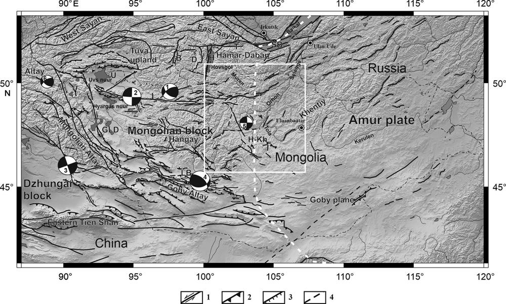
Fig.1 Neotectonic scheme of the territory of Mongolia and its surroundings. 1—strike-slip faults; 2—reverse faults and thrusts; 3—normal faults; 4—prospective faults. Beach balls show the mechanisms of earthquakes with M> 7, 1—Tsetserleg (1905, M=8.2), 2—Bolnay (1905, M=8.4), 3—Gobi-Altay (1957, Mw=8.1), 4—Fuyun (1934, Mw=8.0), 5—Mogod (1967, Mw=7.0), 6—Chuya (2003, Mw=7.3) (Dugarmaa and Shlupp, 2000; Radziminovich et al., 2016). The white dotted line shows the position of the western boundary of the Amur Plate (Zonenshain and Savostin, 1979).

Fig.2 Scheme of Pliocene-Quaternary faults of the central part of Magnolia. The study areas are marked with rectangles. 1—Hangay-Khentiy tectonic saddle; 2—Burgut block (Orhon-Tola interfluve); 3—Selenga depression and Buren-Nuruu uplift. The shaded area in the picture is the zone of the possible position of the western border Amur plate (Zonenshain and Savostin, 1979). For legends see Fig.1. Faults with signs of Holocene displacements are shown by thick lines. Quaternary deposits are colored gray. Small open circles are the point of observations.
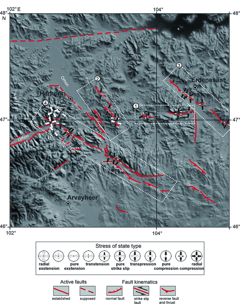
Fig.3 Scheme of faults of Late Pleistocene-Holocene activation and Late Cenozoic paleostressed state of the Hangay-Khentiy tectonic saddle area Mongolia

Fig.4 Scheme of faults of the Late Pleistocene-Holocene activation and the Late Cenozoic paleostressed state of the Earth’s crust in the Burgut block. Legends in Fig.3.
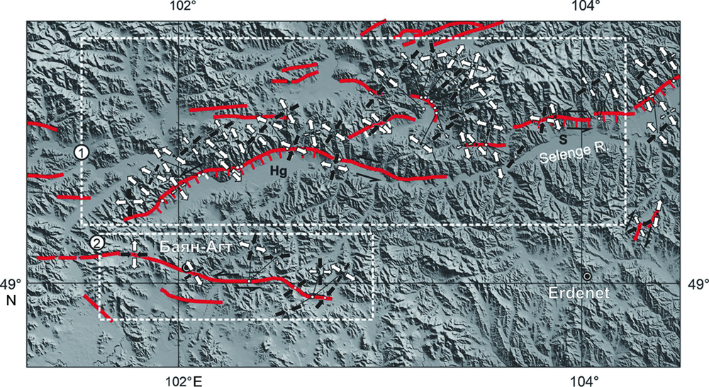
Fig.5 Scheme of faults of the Late Pleistocene-Holocene activation and the Late Cenozoic paleostressed state of the Earth’s crust of the Buren-Nuruu uplift and the Selenga depression. Hg—Khutag depression, S—Selenga depression. Legends in Fig.3.

Fig.6 Kinematics of active faults and the results of reconstruction of the Late Cenozoic field of tectonic stresses of the Earth’s crust in Central Mongolia. Left column—rose diagrams of active fault directions; middle column—reconstruction of the generalized prevailing stress tensor based on tectonic fracturing data; the right column—the same for the generalized second most common stress tensor.
| [1] | Arjannikova, A., Larroque, C., Ritz, J. F., et al., 2004. Geometry and kinematics of recent deformation in the Mondy-Tunka area (south-westernmost Baikal rift zone, Mongolia-Siberia). Terra Nova 16(5), 265-272. |
| [2] | Arzhannikova, A., Arzhannikov, S., Jolivet, M., et al., 2011. Pliocene to Quaternary deformation in South East Sayan (Siberia): Initiation of the Tertiary compressive phase in the southern termination of the Baikal Rift System. Journal of Asian Earth Sciences 40(2), 581-594. |
| [3] | Badarch, G., Cunningham, W. D., Windley, B. F., 2002. A new subdivision for Mongolia: Implications for the Phanerozoic crustal growth of Central Asia. Journal of Asian Earth Sciences 21(1), 87-110. |
| [4] | Bayasgalan, A., Jackson, J. A., 1999. A re-assessment of the faulting in the 1967 Mogod earthquakes in Mongolia. Geophysical Journal International 138(3), 784-800. |
| [5] | Bayasgalan, A., Jackson, J., Ritz, J. F., et al., 1999. Field examples of strike-slip fault terminations in Mongolia and their tectonic significance. Tectonics 18(3), 394-411. |
| [6] | Bollinger, L., Klinger, Y., Forman, S. L., et al., 2021. 25000 years long seismic cycle in a slow deforming continental region of Mongolia. Scientific Reports 11, 17855. |
| [7] |
Calais, E., Vergnolle, M., Sankov, V., et al., 2003. GPS measure-ments of crustal deformation in the Baikal-Mongolia area (1994-2002): Implications for current kinematics of Asia. Journal of Geophysical Research: Solid Earth 108(B10), 2501. DOI: 10.1029/2002JB002373.
DOI |
| [8] | Chen, M., Niu, F., Liu, Q., et al., 2015. Mantle-driven uplift of Hangai Dome: New seismic constraints from adjoint tomography. Geophysical Research Letters 42(17), 6967-6974. |
| [9] | Cunningham, D., 2013. Mountain building processes in intracontinental oblique deformation belts: Lessons from the Gobi Corridor, Central Asia. Journal of Structural Geology 46, 255-282. |
| [10] | Cunningham, W. D., 2001. Cenozoic normal faulting and regional doming in the southern Hangay region, Central Mongolia: Implications for the origin of the Baikal rift Province. Tectonophysics 331(4), 389-411. |
| [11] | Cunningham, W. D., Windley, B. F., Dorjnamjaa, D., et al., 1996. Late Cenozoic transpression in southwestern Mongolia and the Gobi Altai-Tien Shan connection. Earth and Planetary Science Letters 140(1/2/3/4), 67-81. |
| [12] | De, Grave, J., Buslov, M. M., Van, Den, Haute, P., 2007. Distant effects of India-Eurasia convergence and Mesozoic intracontinental deformation in Central Asia: Constraints from apatite fission-track thermochronology. Journal of Asian Earth Sciences 29(2/3), 188-204. |
| [13] | Dehandschutter, B., Vysotsky, E., Delvaux, D., et al., 2002. Structural evolution of the Teletsk graben (Russian Altai). Tectonophysics 351(1/2), 139-167. |
| [14] | Delvaux, D., 1993. The TENSOR program for reconstruction: Examples from East African and the Baikal rift systems. EUG VII Strasbourg (Abstracts supplement N° 1 to TERRA Nova) 5, 216. |
| [15] | Delvaux, D., 2012. Release of program Win-Tensor 4.0 for tectonic stress inversion: Statistical expression of stress parameters. Geophysical Research Abstracts (EGU General Assembly) 14, EGU2012-5899. |
| [16] | Delvaux, D., Moyes, R., Stapel, G., et al., 1997. Paleostress reconstructions and geodynamics of the Baikal region, Central Asia, Part 2. Cenozoic rifting. Tectonophysics 282(1/2/3/4), 1-38. |
| [17] | Devyatkin, E. V., 1981. The Cenozoic of Inner Asia (stratigraphy, geochronology, correlation). In: The Joint Soviet-Mongolian Scientific-Research Geological Expedition. Nauka, Moscow, 196 (in Russian). |
| [18] | Dugarmaa, T., Shlupp, A., 2000. One century of seismicity of Mongolia. RCAG MAS, Ulaanbaatar. |
| [19] | Dzhurik, V. I., Dugarmaa, T., 2004. Complex geophysical and seismological investigations in Mongolia. R esearch Centre of Astronomy and Geophysics of the Mongolian Academy of Sciences, Ulaanbaatar; Institute of the Earth’s Crust SB RAS, Irkutsk, 314. |
| [20] | Geological map of Mongolia, 1998. Scale 1∶1000000, Ulaanbaatar. |
| [21] | Goldin, S. V., Kuchai, O. A., 2007. Seismic strain in the Altai-Sayan active seismic area and elements of collisional geodynamics. Russian Geology and Geophysics 48(7), 536-557. |
| [22] | Jolivet, M., Ritz, J. F., Vassallo, R., et al., 2007. Mongolian summits: an uplifted, flat, old but still preserved erosion surface. Geology 35(10), 871-874. |
| [23] | Karagianni, I., Papazachos, C. B., Scordilis, E. M., et al., 2015. Reviewing the active stress field in Central Asia by using a modified stress tensor approach. Journal of Seismology 19(2), 541-565. |
| [24] | Levi, K. G., 2007. Map of neotectonics of the north-eastern sector of Asia (scale 1∶7500000). IEC SB RAS (in Russian), Irkutsk. |
| [25] | Levi, K. G., Miroshnitchenko, A. I., Parfeevets, A. V., et al., 2004. Active faults and stress field of Mongolia. Complex geophysical and seismological investigations in Mongolia. RCAG MAN, Ulaanbaatar-Irkutsk, 88-103. |
| [26] | Logatchev, N. A., Zorin, Y. A., 1987. Evidence and causes of the two-stage development of the Baikal rift. Tectonophysics 143(1/2/3), 225-234. |
| [27] | Lukhnev, A. V., Sankov, V. A., Miroshnichenko, A. I., et al., 2010. GPS rotation and strain rates in the Baikal-Mongolia region. Russian Geology and Geophysics 51(7), 785-793. |
| [28] | Molnar, P., Tapponier, P., 1975. Cenozoic tectonics of Asia: Effects of a continental collision. Science 189(4201), 419-426. |
| [29] | Nikolaeva, T.V., Shuvalov, V. F., 1969. The main stages of sedimentation and relief development in Central Mongolia in the Mesozoic and Cenozoic. Bulletin of Leningrad State University 18(3), 17-21 (in Russian). |
| [30] | Parfeevets, A. V., Sankov, V. A., 2010. Late Cenozoic fields of the tectonic stresses in Western and Central Mongolia. Izvestiya, Physics of the Solid Earth 46(5), 367-378. |
| [31] | Parfeevets, A. V., Sankov, V. A., 2012. Late Cenozoic tectonic stress fields of the Mongolian Microplate. Comptes Rendus: Geoscience 344(3/4), 227-238. |
| [32] | Parfeevets, A. V., Sankov, V. A., 2018. Geodynamic conditions for Cenozoic activation of tectonic structures in Southeastern Mongolia. Geodynamics & Tectonophysics 9(3), 855-888. |
| [33] | Parfeevets, A. V., Sankov, V. A., Demberel, S., 2016. Active faults in the basin of the Selenga, Orhon and Tola Rivers (Northern Mongolia). Geography and Natural Resources 6, 86-92 (in Russian). |
| [34] | Petit, C., Déverchère, J., Calais, E., et al., 2002. Deep structure and mechanical behavior of the lithosphere in the Hangai-Hövsgöl region, Mongolia: New constraints from gravity modeling. Earth and Planetary Science Letters 197(3/4), 133-149. |
| [35] |
Radziminovich, N. A., Bayar, G., Miroshnichenko, A. I., et al., 2016. Focal mechanisms of earthquakes and stress field of the crust in Mongolia and its surroundings. Geodynamics & Tectonophysics 7(1), 23. DOI: 10.5800/GT-2016-7-1-0195.
DOI |
| [36] | Radziminovich, N. A., Bayar, G., Ulziybat, M., et al., 2017. Seismicity, mechanisms of earthquake foci and stress-strain state of the Earth’s crust in Central Mongolia. In: Hazardous geological processes and forecasting of natural emergencies in the territory of Central Mongolia D.P. Gladkochub. Publishing House of the SB RAS, Novosibirsk, 59-69. |
| [37] | Rasskazov, S. V., Chuvashova, I. S., Yasnygina, T. A., et al., 2012. Potassiс and potassic-sodic volcanic series in the Cenozoic of Asia. Geo Academic Publishing House, Novosibirsk, 351 (in Russian). |
| [38] | Ritz, J. F., Bourlès, D., Brown, E. T., et al., 2003. Late Pleistocene to Holocene slip rates for the Gurvan Bulag thrust fault (Gobi-Altay, Mongolia) estimated with 10Be dates. Journal of Geophysical Research 108(B3), 2162. |
| [39] | Rizza, M., Ritz, J. F., Prentice, C., et al., 2015. Earthquake geology of the Bulnay fault (Mongolia). Bulletin of the Seismological Society of America 105(1), 72-93. |
| [40] | Sankov, V. A., Microshnichenko, A. I., Parfeevets, A. V., et al., 2004. Late Cenozoic state of stress in the Earth’s crust of the Khubsugul region (Northern Mongolia): Field and experimental evidence. Geotectonics 38(2), 142-152. |
| [41] | Sankov, V. A., Parfeevets, A. V., 2005. Late Cenozoic stressed state of active fault zones in western Mongolia and Tuva. Doklady Earth Sciences 403A(6), 852-855. |
| [42] | Sankov, V. A., Parfeevets, A. V., Miroshnichenko, A. I., et al., 2015. Active faults paragenesis and the state of crustal stresses in the Late Cenozoic in Central Mongolia. Geodynamics & Tectonophysics 6(4), 491-518. |
| [43] | Scarborough, O. M., 1993. Seismotectonics and seismicity of Ciskhubsugulia. Nauka, Novosibirsk, 184 (in Russian). |
| [44] | Seredkina, A., Kozhevnikov, V., Melnikova, V., et al., 2016. Seismicity and S-wave velocity structure of the crust and the upper mantle in the Baikal rift and adjacent regions. Physics of the Earth and Planetary Interiors 261, 152-160. |
| [45] | Sherman, S. I., Ma, J., Gorbunova, Е. А., 2015. Recent strong earthquakes in Central Asia: Regular tectonophysical features of locations in the structure and geodynamics of the lithosphere. Part 1. Main geodynamic factors predetermining locations of strong earthquakes in the structure of the lithosphere in Central Asia. Geodynamics & Tectonophysics 6(4), 409-436. |
| [46] | Smekalin, O. P., Imaev, V. S., Chipizubov, A. V., 2013. Paleoseismic studies of the Hustai Fault zone (Northern Mongolia). Russian Geology and Geophysics 54(7), 724-733. |
| [47] | Solonenko, V. P., Florensov, N. A., 1985. Earthquakes and fundamentals of seismic risk zoning of Mongolia. Nauka, Moscow, 224 (in Russian). |
| [48] | Tiberi, C., Deschamps, A., Déverchère, J., et al., 2008. Asthenospheric imprints on the lithosphere in Central Mongolia and southern Siberia from a joint inversion of gravity and seismology (MOBAL experiment). Geophysical Journal International 175(3), 1283-1297. |
| [49] | Trifonov, V. G., Makarov, V. I., 1988. Active faults. In: Kropotkin, P.N. (Ed.), Neotectonics and modern geodynamics of mobile belts. Nauka, Moscow, 239-272(in Russian). |
| [50] | Trifonov, V. G., Soboleva, O. V., Trifonov, S. V., et al., 2002. Modern Geodynamics of Alpine-Himalayan Collision Belt. GEOS, Moscow, 225 (in Russian). |
| [51] | Walker, R. T., Molor, E., Fox, M., et al., 2008. Active tectonics of an apparently aseismic region: Distributed active strike-slip faulting in the Hangay Mountains of Central Mongolia. Geophysical Journal International 174(3), 1121-1137. |
| [52] | Walker, R. T., Nissen, E., Molor, E., et al., 2007. Reinterpretation of the active faulting in Central Mongolia. Geology 35(8), 759-762. |
| [53] | Zonenshain, L. P., Savostin, L. A., 1979. Introduction to geodynamics. Nedra, Moscow, 311 (in Russian). |
| [54] | Zorin, Y. A., Mordvinova, V. V., Turutanov, E. K., et al., 2002. Low seismic velocity layers in the Earth’s crust beneath Eastern Siberia (Russia) and Central Mongolia: Receiver function data and their possible geological implication. Tectonophysics 359(3/4), 307-327. |
| [1] | 杨雅军, 杨晓平, 江斌, 汪岩, 庞雪娇. 大兴安岭中生代火山岩地层时空分布与蒙古—鄂霍茨克洋、古太平洋板块俯冲作用响应[J]. 地学前缘, 2022, 29(2): 115-131. |
| [2] | 刘宝山, 程招勋, 寇林林, 邓昌州, 杨晓平, 张春鹏, 李成禄, 韩仁萍. 黑龙江多宝山地区晚三叠世岩浆活动对蒙古—鄂霍茨克洋南向俯冲的响应[J]. 地学前缘, 2022, 29(2): 132-145. |
| [3] | 李文龙, 杨晓平, 钱程, 李成禄, 吕明奇, 程招勋, 王立佳. 大兴安岭北段富克山岩浆弧的组成:对蒙古—鄂霍茨克洋南向俯冲的制约[J]. 地学前缘, 2022, 29(2): 146-163. |
| [4] | 王涛, 张建军, 李舢, 童英, 郭磊, 张晓伟, 黄河, 张磊, 薛怀民. 东北亚晚古生代—中生代岩浆时空演化:多重板块构造体制范围及叠合的鉴别证据[J]. 地学前缘, 2022, 29(2): 28-44. |
| [5] | 唐利, 张寿庭, 王亮, 裴秋明, 方乙, 曹华文, 邹灏, 尹少波. 浅覆盖区隐伏萤石矿找矿预测:以内蒙古赤峰俄力木台为例[J]. 地学前缘, 2021, 28(3): 208-220. |
| [6] | 欧阳鑫, 章永梅, 顾雪祥, 刘丽, 王路智, 高丽晔. 内蒙古撰山子金矿床流体包裹体特征与矿床成因[J]. 地学前缘, 2021, 28(2): 320-332. |
| [7] | 张达玉, 付翔, 位鸥祥, 叶龙翔, 蒋华, 张永, 辛后田. 内蒙古北山小狐狸山钼多金属矿区志留纪安山玢岩的发现及其地质意义[J]. 地学前缘, 2020, 27(3): 222-238. |
| [8] | 王银宏, 刘家军, 张梅, 张方方, 王康, 咸雪辰, 郭灵俊. 内蒙古阿扎哈达铜铋矿床流体包裹体和碳-氧-硫-铅同位素地球化学研究[J]. 地学前缘, 2020, 27(2): 391-404. |
| [9] | 彭润民, 王建平. 华北克拉通北缘西段新元古代裂谷的确认与成矿[J]. 地学前缘, 2020, 27(2): 420-441. |
| [10] | 张欲清, 张长厚, 侯丽玉, 张逸鹏, 黄滢竹, 陈汉林, 常利忠. 内蒙古东南部西拉木伦缝合带两侧二叠纪以来的叠加褶皱变形:对同碰撞和碰撞后变形的启示[J]. 地学前缘, 2019, 26(2): 264-280. |
| [11] | 赵院冬,车继英,许逢明,朱群,王奎良. 兴安地块东北部晚侏罗世C型埃达克质花岗岩年代学、地球化学特征及构造环境意义[J]. 地学前缘, 2018, 25(6): 240-253. |
| [12] | 刘瑞麟,武广,李铁刚,陈公正,武利文,章培春,张彤,江彪,刘文元. 大兴安岭南段维拉斯托锡多金属矿床LA-ICP-MS锡石和锆石U-Pb年龄及其地质意义[J]. 地学前缘, 2018, 25(5): 183-201. |
| [13] | 徐备,徐严,栗进,李群生. 内蒙古西部温都尔庙群的时代及其在中亚造山带中的位置[J]. 地学前缘, 2016, 23(6): 120-127. |
| [14] | 王璞珺, 赵然磊, 蒙启安, 瞿雪姣, 朱德丰, 高有峰. 白垩纪松辽盆地:从火山裂谷到陆内拗陷的动力学环境[J]. 地学前缘, 2015, 22(3): 99-117. |
| [15] | 秦亚, 梁一鸿, 邢济麟, 张青伟, 刘城先. 内蒙古正镶白旗地区早古生代O型埃达克岩的厘定及其意义[J]. 地学前缘, 2013, 20(5): 106-114. |
| 阅读次数 | ||||||
|
全文 |
|
|||||
|
摘要 |
|
|||||