地学前缘 ›› 2021, Vol. 28 ›› Issue (2): 71-84.DOI: 10.13745/j.esf.sf.2020.9.2
范宣梅( ), 戴岚欣, 钟育瑾, 李婧娟, 王兰生
收稿日期:2020-08-20
修回日期:2020-09-10
出版日期:2021-03-25
发布日期:2021-04-03
作者简介:范宣梅(1981—),女,研究员,博士生导师,主要从事地质灾害风险评价与防治研究。E-mail: fxm_cdut@qq.com
基金资助:
FAN Xuanmei(), DAI Lanxin, ZHONG Yujin, LI Jingjuan, WANG Lansheng
Received:2020-08-20
Revised:2020-09-10
Online:2021-03-25
Published:2021-04-03
摘要:
四川岷江上游叠溪发育有一套厚度超过200 m、保存较为完整的湖相沉积,被定名为叠溪古堰塞湖相沉积,其形成于距今30 ka前,存活了约15 ka,因此记录了青藏高原东缘晚更新世—全新世(包括末次冰期)的重大地质与环境事件。现有研究初步揭示了古堰塞的沉积特征,但对叠溪古滑坡及古堰塞湖形成与演化的系统研究还十分不足。本文通过详细的野外调查,结合现代遥感测绘技术(无人机载LiDAR),构建叠溪古滑坡的三维地质模型,研究了其地质与地貌特征。同时,采用高密度电阻率法ERT,在滑坡体上布设2条长870 m和990 m的测线,探明了滑坡体内部结构特征。通过古堰塞湖相沉积露头和钻孔的调查,结合激光粒度测试,重建了古堰塞湖的范围、规模与沉积特征。在此基础上,通过对古湖相沉积坡面上多级阶地的分析,初步探讨了古堰塞湖的消亡及其对下游史前古聚落变迁的影响。研究结果表明,叠溪古滑坡不仅完全堵塞岷江而且还堵塞了对岸支沟,堆积体方量达到(1 400~2 000)×106 m3。古堰塞湖在滑坡坝后向上游延伸26 km,所形成的最大湖面覆盖面积约21.4 km2,库容蓄水量约1 670×106 m3。叠溪古滑坡-堰塞湖在岷江上游形成了陡峭的河道裂点(Knickpoint),对山区河道与地貌演化具有长期影响。
中图分类号:
范宣梅, 戴岚欣, 钟育瑾, 李婧娟, 王兰生. 岷江上游叠溪古滑坡坝-堰塞湖研究进展[J]. 地学前缘, 2021, 28(2): 71-84.
FAN Xuanmei, DAI Lanxin, ZHONG Yujin, LI Jingjuan, WANG Lansheng. Recent research on the Diexi paleo-landslide: dam and lacustrine deposits upstream of the Minjiang River, Sichuan, China[J]. Earth Science Frontiers, 2021, 28(2): 71-84.

图1 四川岷江上游叠溪古滑坡坝-堰塞湖研究区位置图 a—巴颜喀喇断块及研究区位置;b—研究区地质图。
Fig.1 (a) Tectonic map of the Qinghai-Tibet Plateau showing the location of the study area, and (b) geological map of the study area showing the locations of the Diexi paleo-landslide dam and lake upstream of the Minjiang River, Sichuan
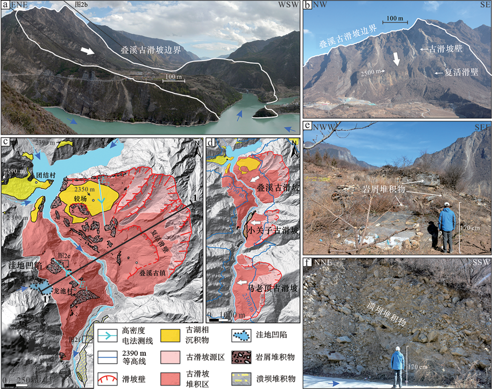
图2 叠溪古滑坡地貌及堆积特征 a—叠溪古滑坡全景照片;b—左岸滑坡源区全景照片;c—叠溪古滑坡坝地貌解译详图;d—叠溪区域古滑坡群解译图;e—右岸龙池村平台的大块石岩屑堆积物;f—滑坡坝下游的溃坝堆积体。蓝色箭头指示现今岷江河流方向。
Fig.2 Geomorphological and depositional features of the Diexi paleo-landslide

图3 叠溪古滑坡纵剖面图 剖面位置见图2c。
Fig.3 Geological profile of the Diexi paleo-landslide

图4 叠溪古滑坡坝体高密度电阻率法物探及湖相沉积物钻孔 a—高密度电阻率法布线与钻孔分布图;b—龙池平台滑坡堆积体电阻率E1剖面图;c—较场平台湖相沉积物高密度电阻率E2剖面图。 钻孔(2009)资料据文献[3];钻孔ZK1-ZK3(2018)为本文作者团队2018年沉积取心钻孔。
Fig.4 Geophysical measurements (a) and ERT profile (b, c) of the Diexi paleo-landslide dam

图5 叠溪古堰塞湖范围重建 a—基于湖相沉积物分布重建的古堰塞湖范围;b—湖相沉积物钻孔揭露的古堰塞湖横剖面。a包括古湖相沉积出露位置与取样点分布;b中剖面线位置与钻孔信息见图4a。
Fig.5 Reconstruction of the Diexi paleo-lake
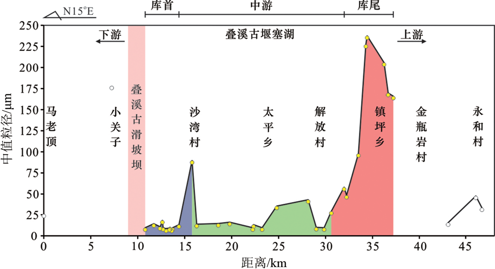
图6 古湖相沉积物粒度从坝址到上游库尾的空间变化图
Fig.6 Grain size distributions in the paleo-lacustrine deposit from the dam site to the end of the lake
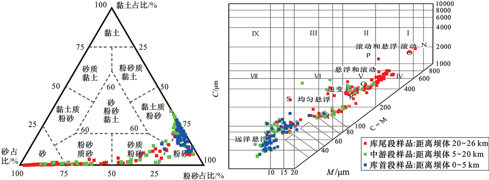
图7 古湖相沉积物的粒度特征 a—三角分类图;b—C-M图。
Fig.7 Grain size variations in sediment samples collected from the dam (blue square), mid-lake (green square) and lake-end (red square) sections of the Diexi paleo-lake deposit
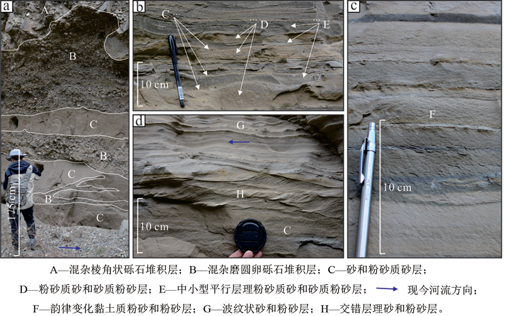
图8 古堰塞湖的沉积特征 a—库尾河湖交汇相;b—中游段沉积剖面;c—库首段沉积剖面;d—交错层理结构。
Fig.8 Sedimentologic characteristics of the Diexi paleo-lake deposit
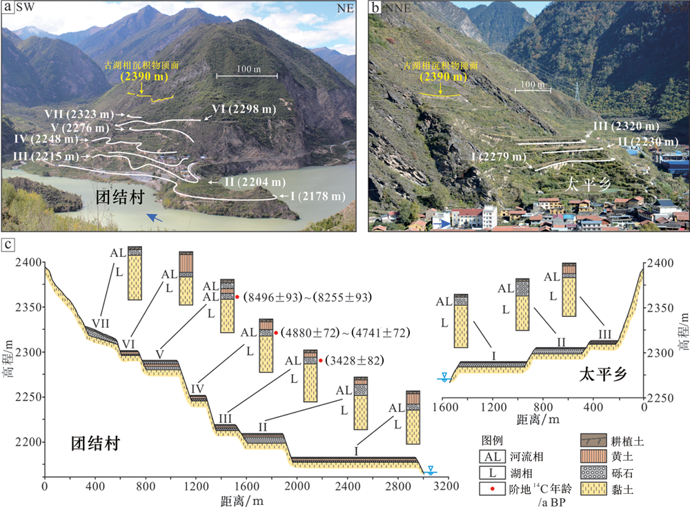
图9 叠溪古堰塞消亡过程形成的河流相阶地(c图中阶地14C测年数据引自文献[3]) a—团结村发现的7级阶地;b—太平村发现的3级阶地;c—阶地露头沉积相划分和测年结果复合剖面示意图。
Fig.9 Fluvial terraces embedded in the Diexi paleo-lake deposit. 14C data adapted from [3].
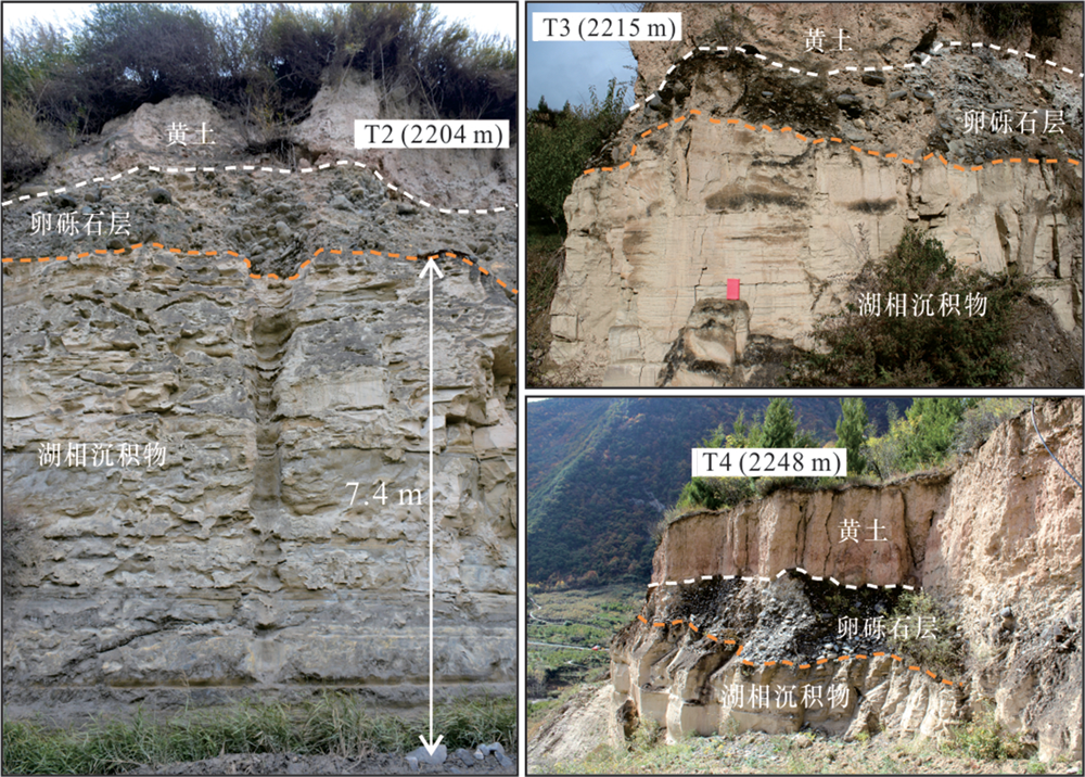
图10 河流相阶地沉积特征
Fig.10 Sedimentologic characteristics of the fluvial terraces

图11 1933年叠溪地震复活的古滑坡体(a据文献[39]) a—尔尼斯特·亨利·威尔逊拍摄于1910年8月30日的叠溪老照片,拍摄地点见图11c;b—基于三维可视化模型获取的叠溪2018年景观(与图11a取景一致);c—1933年叠溪地震中复活的古滑坡体解译图。
Fig.11 The paleo-landslide reactivated by the 1933 Diexi earthquake. Photo in (a) adapted from [39].

图12 叠溪段裂点、陡峭系数和汇水面积复合河道纵剖面
Fig.12 Longitudinal profile of the Minjiang River around the Diexi paleo-landslide dam, showing the knickpoints (star), steepness indexes (circle), and upstream catchment contribution area

图13 ZK1(2018)钻孔岩心照片 a—ZK1(2018)钻孔从孔顶至孔底方向31.17~31.88 m段取心照片;b—枕状构造、负载构造、球状构造;c—负载构造;d—碟状构造;e—碟状构造、液化变形构造;f—微断层;g—纹层。
Fig.13 Photos of the ZK1 (2018) core (a) and core sections showing various core structural features (b-g)

图14 岷江上游古堰塞湖与史前聚落分布图(古堰塞湖分布据文献[2],史前聚落分布据文献[49])
Fig.14 Distribution of the dammed paleo-lakes (adapted from [2]) and prehistoric settlements (adapted from [49]) in the upstream catchment of the Minjiang River
| [1] | 王兰生, 杨立铮, 王小群, 等. 岷江叠溪古堰塞湖的发现[J]. 成都理工大学学报(自然科学版), 2005,32(1):1-11. |
| [2] | 王兰生, 王小群, 许向宁, 等. 岷江上游近两万年前发生了什么事件?[J]. 地学前缘, 2007,14(4):189-196. |
| [3] | 王兰生, 王小群, 许向宁, 等. 岷江叠溪古堰塞湖的研究意义[J]. 第四纪研究, 2012,32(5):998-1010. |
| [4] |
ZHAO S Y, CHIGIRA M, WU X Y. Gigantic rockslides induced by fluvial incision in the Diexi area along the eastern margin of the Tibetan Plateau[J]. Geomorphology, 2019,338:27-42.
DOI URL |
| [5] | FAN X M, YUNUS A P, JANSEN J D, et al. Comment on ‘Gigantic rockslides induced by fluvial incision in the Diexi area along the eastern margin of the Tibetan Plateau’ by Zhao et al. (2019) Geomorphology 338, 27-42[J]. Geomorphology, 2019: 106963. |
| [6] | 罗晓康, 殷志强, 杨龙伟. 岷江上游河流阶地发育特征及与古滑坡关系初步分析[J]. 第四纪研究, 2019,39(2):391-398. |
| [7] | 杨文光, 朱利东, 郑洪波, 等. 岷江上游第四纪叠溪古堰塞湖的演化[J]. 地质通报, 2008,27(5):605-610. |
| [8] | 杨文光, 朱利东, 张岩, 等. 岷江上游茂县古堰塞湖的沉积演化[J]. 海洋地质前沿, 2011,27(5):35-40. |
| [9] |
XU H, CHEN J, CUI Z J, et al. Sedimentary facies and depositional processes of the Diexi Ancient Dammed Lake, upper Minjiang River, China[J]. Sedimentary Geology, 2020,398:105583.
DOI URL |
| [10] | 许会, 陈剑, 崔之久, 等. 堰塞湖沉积物粒度特征分析:以岷江上游叠溪古堰塞湖为例[J]. 沉积学报, 2019,37(1):51-61. |
| [11] | 安卫平, 赵晋泉, 闫小兵, 等. 岷江断裂羌阳桥一带古堰塞湖沉积及构造变形与古地震[J]. 地震地质, 2008,30(4):980-988. |
| [12] | 张斌, 王萍, 王建存. 岷江上游堰塞湖沉积中软沉积物变形构造成因讨论[J]. 地震研究, 2011,34(1):67-74. |
| [13] |
WANG P, ZHANG B, QIU W L, et al. Soft-sediment deformation structures from the Diexi paleo-dammed lakes in the upper reaches of the Minjiang River, east Tibet[J]. Journal of Asian Earth Sciences, 2011,40(4):865-872.
DOI URL |
| [14] |
JIANG H C, MAO X, XU H Y, et al. Provenance and earthquake signature of the last deglacial Xinmocun lacustrine sediments at Diexi, east Tibet[J]. Geomorphology, 2014,204:518-531.
DOI URL |
| [15] | 沈曼, 王小群, 许峰, 等. 叠溪古堰塞湖地震扰动沉积物特征[J]. 成都理工大学学报(自然科学版), 2014,41(3):369-377. |
| [16] |
WEI Y F, WANG X Q, SHENG M, et al. Reproduction of the sedimentary disturbance phenomenon of the Diexi ancient landslide-dammed lake under earthquake[J]. Journal of Mountain Science, 2015,12(5):1181-1188.
DOI URL |
| [17] |
XU H Y, JIANG H C, YU S, et al. OSL and pollen concentrate 14C dating of dammed lake sediments at Maoxian, east Tibet, and implications for two historical earthquakes in AD 638 and 952[J]. Quaternary International, 2015,371:290-299.
DOI URL |
| [18] |
LIANG L J, JIANG H C. Geochemical composition of the last deglacial lacustrine sediments in east Tibet and implications for provenance, weathering, and earthquake events[J]. Quaternary International, 2017,430:41-51.
DOI URL |
| [19] |
ZHONG N, JIANG H C, LI H B, et al. Last deglacial soft-sediment deformation at Shawan on the eastern Tibetan Plateau and implications for deformation processes and seismic magnitudes[J]. Acta Geologica Sinica (English Edition), 2019,93(2):430-450.
DOI URL |
| [20] | 钟宁, 蒋汉朝, 李海兵, 等. 岷江上游新磨村湖相沉积物粒度端元反演及其记录的构造和气候事件[J]. 地质学报, 2020,94(3):968-981. |
| [21] | 张岩, 朱利东, 杨文光, 等. 青藏高原东缘叠溪海盆地40~30 ka BP高分辨率快速气候变化记录[J]. 地学前缘, 2009,16(5):91-98. |
| [22] | 王小群, 王兰生, 沈军辉. 岷江上游叠溪古堰塞湖沉积物粒度特征及环境意义[J]. 工程地质学报, 2010,18(5):677-684. |
| [23] | 王小群, 王兰生. 岷江叠溪古堰塞湖沉积物中孢粉特征[J]. 地球科学:中国地质大学学报, 2013,38(5):975-982. |
| [24] | WANG X Q, LI Y R, YUAN Y, et al. Palaeoclimate and palaeoseismic events discovered in Diexi barrier lake on the Minjiang river, China[J]. Natural Hazards and Earth System Sciences, 2014,14(8):2069-2078. |
| [25] | 张岳桥, 李海龙, 李建. 青藏高原30~40 ka BP暖湿气候事件对川西河谷地质环境的影响[J]. 地球学报, 2016,37(4):481-492. |
| [26] |
MA J X, CHEN J, CUI Z J, et al. Sedimentary evidence of outburst deposits induced by the Diexi paleolandslide-dammed lake of the upper Minjiang River in China[J]. Quaternary International, 2018,464:460-481.
DOI URL |
| [27] |
LIU W M, CUI P, GE Y G, et al. Paleosols identified by rock magnetic properties indicate dam-outburst events of the Min River, eastern Tibetan Plateau[J]. Palaeogeography, Palaeoclimatology, Palaeoecology, 2018,508:139-147.
DOI URL |
| [28] |
CHEN R C, CHEN J, MA J X, et al. Quartz grain surface microtextures of dam-break flood deposits from a landslide-dammed lake: a case study[J]. Sedimentary Geology, 2019,383:238-247.
DOI URL |
| [29] | 高翔, 邓起东. 巴颜喀喇断块边界断裂强震活动分析[J]. 地质学报, 2013,87(1):9-19. |
| [30] |
DENG B, LIU S G, LIU S, et al. Progressive Indosinian N-S deformation of the Jiaochang structure in the Songpan-Ganzi Fold-belt, western China[J]. PLOS One, 2013,8(10):e76732.
DOI URL |
| [31] |
GORUM T, FAN X M, VAN WESTEN C J, et al. Distribution pattern of earthquake-induced landslides triggered by the 12 May 2008 Wenchuan earthquake[J]. Geomorphology, 2011,133(3/4):152-167.
DOI URL |
| [32] |
FAN X M, SCARINGI G, XU Q, et al. Coseismic landslides triggered by the 8th August 2017 Ms 7.0 Jiuzhaigou earthquake (Sichuan, China): factors controlling their spatial distribution and implications for the seismogenic blind fault identification[J]. Landslides, 2018,15(5):967-983.
DOI URL |
| [33] |
FAN X M, SCARINGI G, KORUP O, et al. Earthquake-induced chains of geologic hazards: patterns, mechanisms, and impacts[J]. Reviews of Geophysics, 2019,57(2):421-503.
DOI URL |
| [34] |
DUFRESNE A, BÖSMEIER A, BÖSMEIER A . Sedimentology of rock avalanche deposits: case study and review[J]. Earth-Science Reviews, 2016,163:234-259.
DOI URL |
| [35] |
FAN X M, DUFRESNE A, SIVA SUBRAMANIAN S, et al. The formation and impact of landslide dams: state of the art[J]. Earth-Science Reviews, 2020,203:103116.
DOI URL |
| [36] | 李昶. 不同水库淤积形态对总有机碳、总氮埋藏通量的影响[D]. 上海: 华东师范大学, 2018. |
| [37] | 柴贺军, 刘汉超. 一九三三年叠溪地震滑坡堵江事件及其环境效应[J]. 地质灾害与环境保护, 1995,6(1):7-17. |
| [38] | 常隆庆. 四川叠溪地震调查记[J]. 地质论评, 1938,3(3):251-293. |
| [39] | 闫小兵, 安卫平, 赵晋泉, 等. 叠溪地震遗迹拾零[J]. 山西地震, 2009(3):21-25, 31. |
| [40] | 洪时中, 徐吉廷, 王克明. 叠溪地震次生水灾的规模、范围、水文参数与分段特征[J]. 四川地震, 2019(1):5-11. |
| [41] |
KORUP O, STROM A L, WEIDINGER J T. Fluvial response to large rock-slope failures: examples from the Himalayas, the Tien Shan, and the Southern Alps in New Zealand[J]. Geomorphology, 2006,78(1/2):3-21.
DOI URL |
| [42] |
SCHWANGHART W, SCHERLER D. Bumps in river profiles: uncertainty assessment and smoothing using quantile regression techniques[J]. Earth Surface Dynamics, 2017,5(4):821-839.
DOI URL |
| [43] |
ZHANG F, JIN Z, WEST A J, et al. Monsoonal control on a delayed response of sedimentation to the 2008 Wenchuan earthquake[J]. Science Advances, 2019,5(6): eaav7110.
DOI URL |
| [44] |
HOWARTH J D, FITZSIMONS S J, NORRIS R J, et al. Lake sediments record high intensity shaking that provides insight into the location and rupture length of large earthquakes on the Alpine Fault, New Zealand[J]. Earth and Planetary Science Letters, 2014,403:340-351.
DOI URL |
| [45] | 乔秀夫, 李海兵, 苏德辰. 软沉积物变形构造:地震与古地震记录[M]. 北京: 地质出版社, 2017. |
| [46] |
ZOLITSCHKA B, FRANCUS P, OJALA A E K, et al. Varves in lake sediments: a review[J]. Quaternary Science Reviews, 2015,117:1-41.
DOI URL |
| [47] |
WU L Z, ZHAO D J, ZHU J D, et al. A late Pleistocene river-damming landslide, Minjiang River, China[J]. Landslides, 2020,17(2):433-444.
DOI URL |
| [48] | 朱乃诚. 茂县及岷江上游地区在古蜀文明形成中的重要作用与地位[J]. 四川文物, 2020(1):68-76. |
| [49] | 江章华, 何锟宇. 成都平原史前聚落分析[J]. 四川文物, 2016(6):70-78, 83. |
| [50] | 李绍先, 刘晓霞. 地震洪水灾害与三星堆古城的毁弃[J]. 绵阳师范学院学报, 2012,31(10):106-110. |
| [51] | 万娇. 成都十二桥遗址早期堆积的性质及成因分析[J]. 文物, 2017(12):38-47. |
| [52] | 刘兴诗. 成都平原古城群兴废与古气候问题[J]. 四川文物, 1998(4):3-5. |
| [53] | 许婧璟, 张志龙, 戴辉. 岷江上游古堰塞湖溃决与成都黏土形成、古蜀文明消亡的联系[J]. 江西建材, 2017(15):2-3. |
| [1] | 陈运泰. 特大地震及其引发的超级海啸的启示[J]. 地学前缘, 20140101, 21(1): 120-131. |
| [2] | 万天丰. 论构造地质学和大地构造学的几个重要问题[J]. 地学前缘, 20140101, 21(1): 132-149. |
| [3] | 刘远征, 马瑾, 马文涛. 探讨紫坪铺水库在汶川地震发生中的作用[J]. 地学前缘, 20140101, 21(1): 150-160. |
| [4] | 上官拴通, 田兰兰, 潘苗苗, 杨风良, 岳高凡, 苏野, 齐晓飞. 干热岩开发断层滑动及诱发地震风险研究:以唐山马头营干热岩场地为例[J]. 地学前缘, 2024, 31(6): 252-260. |
| [5] | 姜兆霞, 李三忠, 索艳慧, 吴立新. 海底氢能探测与开采技术展望[J]. 地学前缘, 2024, 31(4): 183-190. |
| [6] | 徐继山, 彭建兵, 隋旺华, 安海波, 李作栋, 徐文杰, 董培杰. 郯庐断裂转换段新沂地裂缝成生机理及构造意义[J]. 地学前缘, 2024, 31(3): 470-481. |
| [7] | 徐兆辉, 胡素云, 曾洪流, 马德波, 罗平, 胡再元, 石书缘, 陈秀艳, 陶小晚. 塔里木盆地肖尔布拉克组上段烃源岩分布预测及油气勘探意义[J]. 地学前缘, 2024, 31(2): 343-358. |
| [8] | 成秋明. 洋中脊动力学与俯冲带地震-岩浆-成矿事件远程效应[J]. 地学前缘, 2024, 31(1): 1-14. |
| [9] | 邓琰, 徐玉超, 范晔, 孙贵成, 董泽义, 韩冰. 大地电磁法的应用综述:以川滇地区为例[J]. 地学前缘, 2024, 31(1): 181-200. |
| [10] | LIANG Guanghe. 南海中央海盆高精度地震勘探揭示的大陆漂移过程[J]. 地学前缘, 2023, 30(5): 430-449. |
| [11] | 陈飞, 范洪军, 范廷恩, 张会来, 赵卫平, 井涌泉. 西非尼日尔三角洲盆地A油田深水浊积水道沉积体系沉积特征[J]. 地学前缘, 2023, 30(4): 209-217. |
| [12] | 刘晓宇, 杨文采, 陈召曦, 瞿辰, 于常青. 青藏高原东部地块的属性与演化[J]. 地学前缘, 2023, 30(3): 233-241. |
| [13] | 孙东, 杨涛, 曹楠, 覃亮, 胡骁, 魏萌, 蒙明辉, 张伟. 泸定MS 6.8地震同震地质灾害特点及防控建议[J]. 地学前缘, 2023, 30(3): 476-493. |
| [14] | 陈波. 中国煤矿灾害与地震活动时空分布丛集特征的深入研究[J]. 地学前缘, 2023, 30(2): 548-560. |
| [15] | 梁光河, 杨巍然. 驱动印度大陆北漂的动力是什么?[J]. 地学前缘, 2023, 30(2): 68-80. |
| 阅读次数 | ||||||
|
全文 |
|
|||||
|
摘要 |
|
|||||