地学前缘 ›› 2023, Vol. 30 ›› Issue (3): 476-493.DOI: 10.13745/j.esf.sf.2022.12.50

• 非主题来稿选登 • 上一篇    下一篇

泸定MS 6.8地震同震地质灾害特点及防控建议

孙东1,2,3(), 杨涛1,2,3,*(), 曹楠1,2,3, 覃亮1,2,3, 胡骁2,3, 魏萌2,3, 蒙明辉1,2,3, 张伟1,2,3   

  1. 1.成都水文地质工程地质中心, 四川 成都 610081
    2.四川省地质灾害防治工程技术研究中心, 四川 成都 610081
    3.四川省华地建设工程有限责任公司, 四川 成都 610081
  • 收稿日期:2022-10-13 修回日期:2022-11-29 出版日期:2023-05-25 发布日期:2023-04-27
  • 通讯作者: *杨 涛(1990—),男,硕士,工程师,主要从事地质灾害防治工作。E-mail: 1029193228@qq.com
  • 作者简介:孙 东(1982—),男,博士,正高级工程师,主要从事地质灾害防治工作。E-mail: 67986685@qq.com
  • 基金资助:
    应急管理部地震与地质灾害司科研项目(2022-地震地质司-7);国家重点研发计划项目(2018YFC1505400);四川省地质调查研究院科研项目“巨灾型泥石流韧性防灾抗灾关键技术研究及应用示范”(51000023Y000008287848)

Characteristics and mitigation of coseismic geohazards associated with the Luding MS 6.8 earthquake

SUN Dong1,2,3(), YANG Tao1,2,3,*(), CAO Nan1,2,3, QIN Liang1,2,3, HU Xiao2,3, WEI Meng2,3, MENG Minghui1,2,3, ZHANG Wei1,2,3   

  1. 1. Chengdu Center of Hydrogeology & Engineering Geology, Chengdu 610081, China
    2. Sichuan Province Engineering Technology Research Center of Geohazard Prevention, Chengdu 610081, China
    3. Sichuan Huadi Construction Engineering Co. Ltd., Chengdu 610081, China
  • Received:2022-10-13 Revised:2022-11-29 Online:2023-05-25 Published:2023-04-27

摘要:

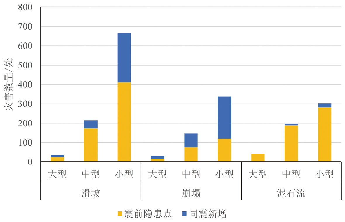
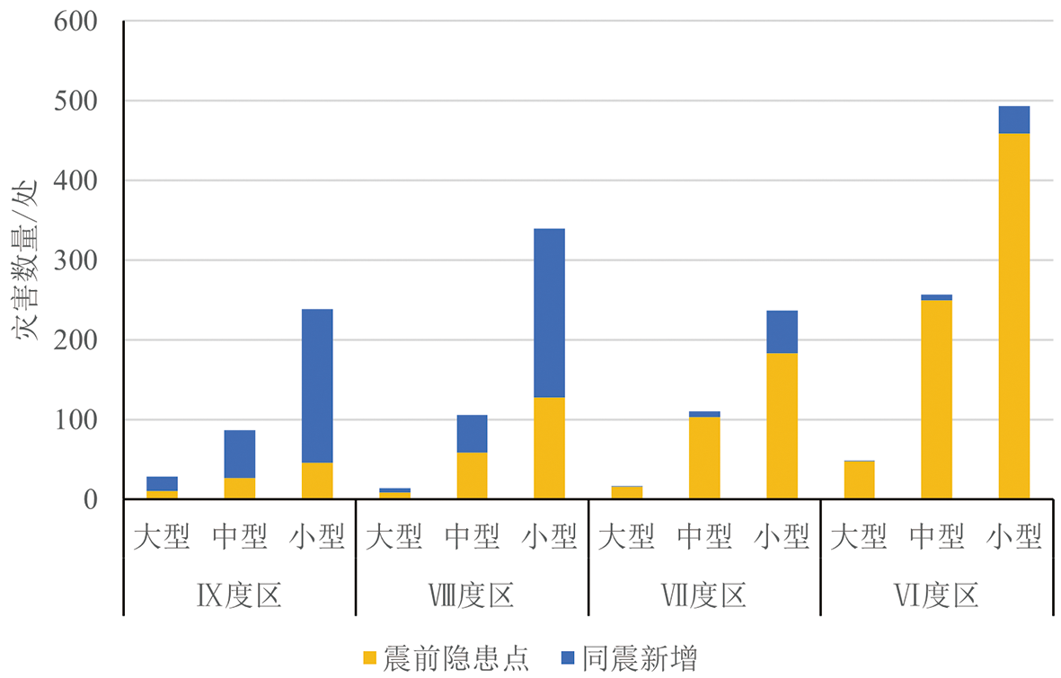
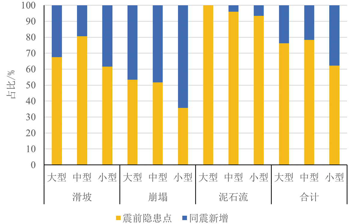
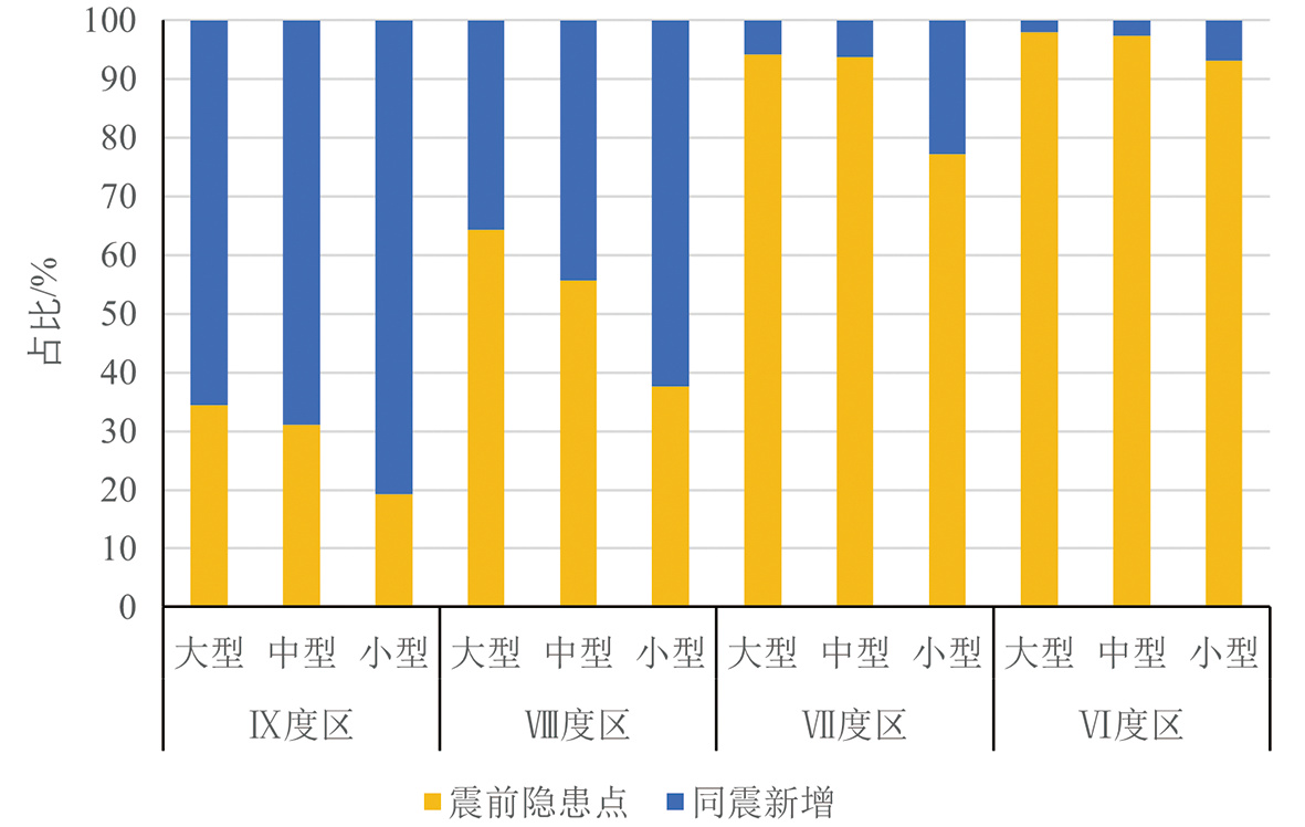
强震区同震地质灾害特点、震后地震效应研究是支撑灾后重建和防灾减灾的关键。本文基于震后重点区无人机高清遥感影像解译、震后地质灾害应急排查、极震区地质灾害详查数据,研究了同震地质灾害的数量、空间分布、控制因素,详细分析了震后地质灾害防治工作面临的3个重要风险,并针对灾后重建中关于地质灾害防治工作提出了4点建议。研究结果显示:(1)同震次生地质灾害规模以小型为主,中型次之,大型较少,主要沿大渡河两岸、交通道路沿线、大渡河右岸支流、发震断裂和其他断裂沿线等部位密集分布;(2)控制同震次生地质灾害的主要因素由强至弱分别是地震动、断裂带、地形坡度、地层岩性和强震区工程设防标准不够;(3)震后地质灾害防治主要面临降雨加剧已有灾害点变形和诱发新的灾害、震裂山体可能演变为高位远程灾害链的风险源区、巨量沟道斜坡物源构成泥石流的潜在物源并形成灾害;(4)建议加强“人技结合”的隐患识别体系机制,构建依靠科技的点面结合监测预警机制,统筹各要素科学实施避让搬迁,提高地震活跃强震区工程建设抗灾标准,构建农村切坡建房的技术支撑机制。

关键词: 泸定地震, 次生地质灾害, 同震地质灾害, 防控

Abstract:

Understanding the characteristics of geohazards and the post-seismic effect in the meizoseismal area is the key to supporting post-disaster reconstruction and disaster mitigation. In this report, the number of coseismic geohazard events following the MS 6.8 earthquake of 2022 in Luding, Sichuan, China, and their spatial distribution and controlling factors are studied based on UAV high-resolution remote sensing image interpretation, post-seismic emergency damage assessments and detailed focus-area investigation. In addition, three important risk factors for post-seismic geohazard mitigation are analyzed, and five recommendations emphasizing post-seismic reconstruction are proposed. The main findings are: (1) The coseismic geohazard events are predominantly small-scaled events and followed by medium-sized events, while large-scaled events are relatively few. These events are densely distributed along the Dadu river and its right tributary, roads, seismogenic fault and other regional faults. (2) The main controlling factors for secondary disasters are, in the order of decreasing dominance, ground motion, fault zone, terrain slope, terrain lithology and low fortification standard in the meizoseismal area. (3) The main issues in the prevention and control of post-seismic geohazards are: rainfall induced aggravation of existing structural deformation and onset of new disasters; the shattered mountains becoming source areas to trigger a chain of remote disasters; and the massive debris on channel slopes becoming a material source to cause mudslide. Accordingly, we suggest to strengthen the hazard identification system combining technology with human intervention, construct high-tech monitoring and early warning systems to monitor both hazard spots and entire slope areas, implement science-based comprehensive avoidance-and-relocation plans, raise anti-earthquake construction engineering standards in earthquake zones, and implement technical support mechanisms in building hillside houses in rural areas.

Key words: Luding earthquake, secondary geohazards, coseismic geohazards, prevention and control

中图分类号: