Earth Science Frontiers ›› 2021, Vol. 28 ›› Issue (4): 373-382.DOI: 10.13745/j.esf.sf.2020.11.1
Previous Articles Next Articles
XUE Tao1( ), SHI Yujin2, ZHU Xiaodi3, WANG Jun2, LIU Ting2
Received:2020-04-21
Revised:2020-09-03
Online:2021-07-25
Published:2021-07-25
CLC Number:
XUE Tao, SHI Yujin, ZHU Xiaodi, WANG Jun, LIU Ting. Research on 3D modeling method for evaluation of urban underground space resources: A case study in Shanghai[J]. Earth Science Frontiers, 2021, 28(4): 373-382.

Fig.1 Process of 3D geological modeling based on multi-source data

Fig.2 Single-layer 3D geological attribute model
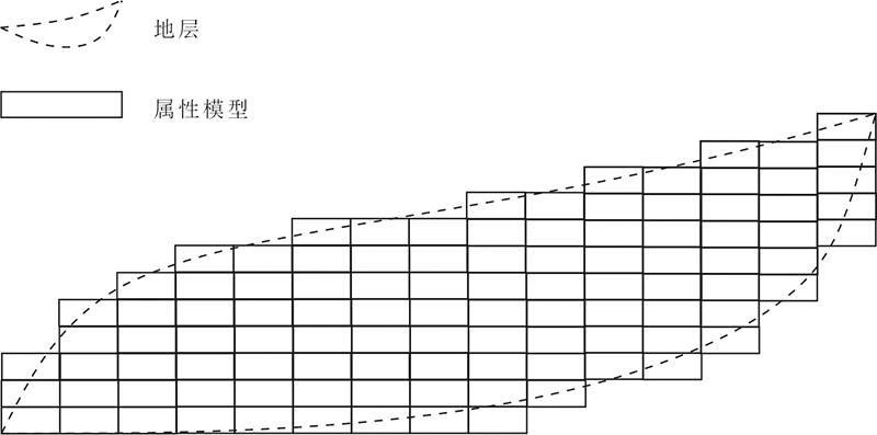
Fig.3 Horizontal-stratified 3D geological attribute model

Fig.4 Comparison between mesh property model and stratum model
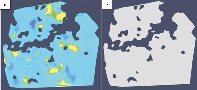
Fig.5 Comparison between tetrahedral property model and stratum model
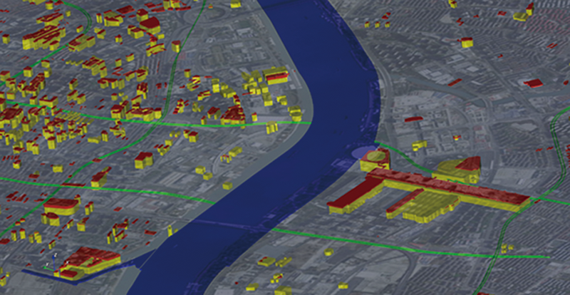
Fig.6 Transparent surface display of the water system model, subway tunnel model, underground structural and pile foundation model (LOD1)
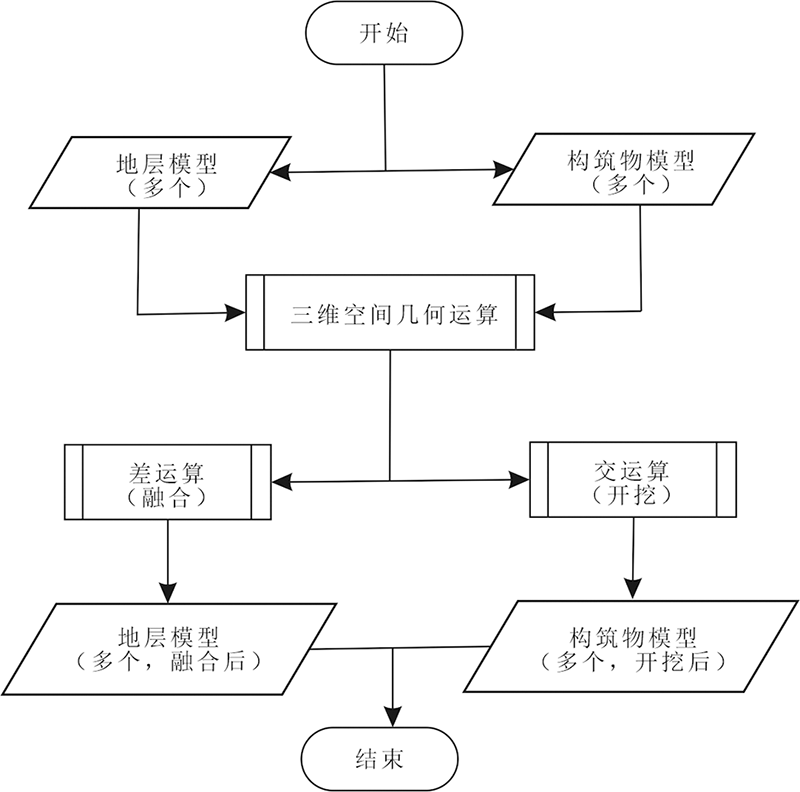
Fig.7 Fusion of stratum and underground structure models and the excavation process
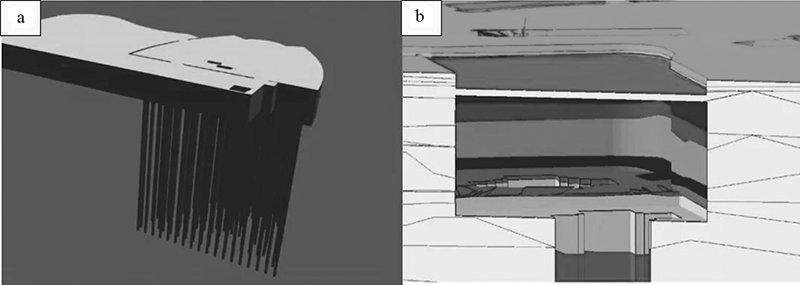
Fig.8 Underground structural model (a) and the result of fusion and excavation (b)
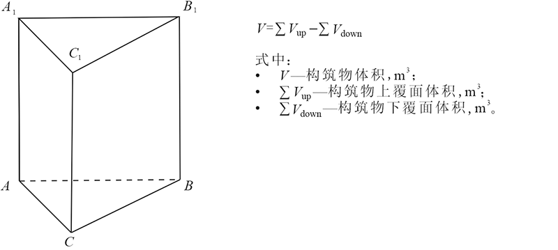
Fig.9 Method for calculating excavation volume of underground structures
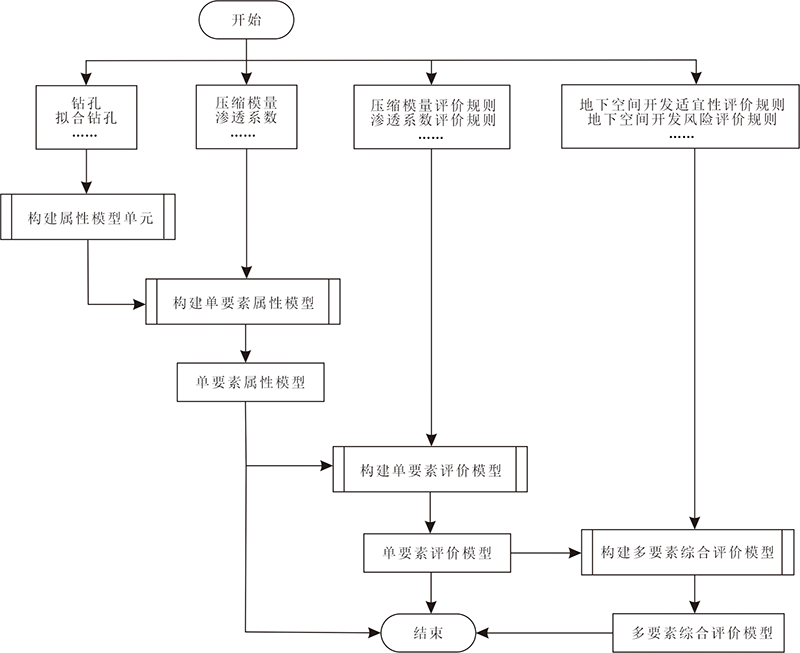
Fig.10 Technical route for underground space resource assessment
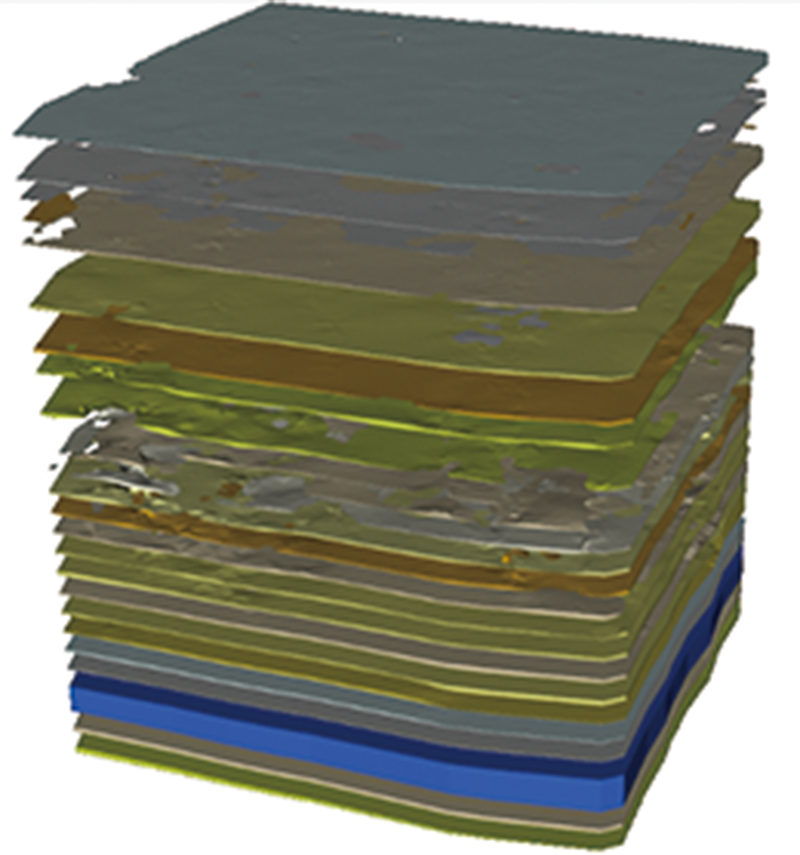
Fig.11 Exploded view of 3D geological structural model
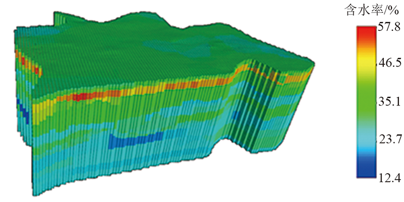
Fig.12 Single-layer 3D geological attribute model
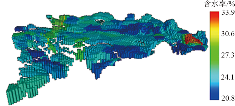
Fig.13 Horizontal-stratified 3D geological attribute model
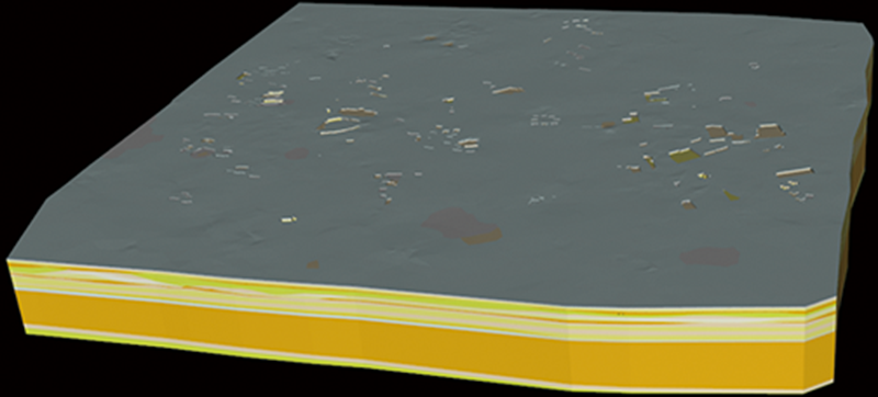
Fig.14 Fusion of stratum model and underground structure of the Shanghai Zhongshan Park demonstration area
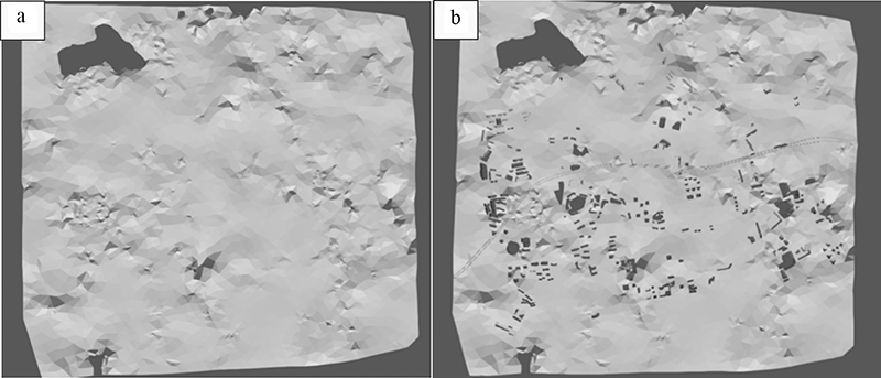
Fig.15 Comparison of before and after fusion of stratum model and underground structure of the Shanghai Zhongshan Park demonstration area
| 序号 | 融合地层 | 原体积/m3 | 融合后体积/m3 | 地下构筑物和桩基开挖量/m3 |
|---|---|---|---|---|
| 1 | 地层①1 | 13 315 800 | 12 837 100 | 479 055 |
| 2 | 地层①2 | 225 854 | 214 096 | 11 714.1 |
| 3 | 地层②1 | 10 641 100 | 10 124 400 | 517 046 |
| 4 | 地层②2 | 1 480 230 | 1 400 840 | 79 275.2 |
| 5 | 地层②3 | 7 479 860 | 7 468 130 | 7 280.34 |
Table 1 Volume automatically measured before and after some stratum fusion with Shanghai Zhongshan Park as demonstration area
| 序号 | 融合地层 | 原体积/m3 | 融合后体积/m3 | 地下构筑物和桩基开挖量/m3 |
|---|---|---|---|---|
| 1 | 地层①1 | 13 315 800 | 12 837 100 | 479 055 |
| 2 | 地层①2 | 225 854 | 214 096 | 11 714.1 |
| 3 | 地层②1 | 10 641 100 | 10 124 400 | 517 046 |
| 4 | 地层②2 | 1 480 230 | 1 400 840 | 79 275.2 |
| 5 | 地层②3 | 7 479 860 | 7 468 130 | 7 280.34 |
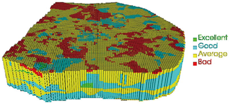
Fig.16 Evaluation of underground space resources in the central district of Shanghai
| [1] | 程光华, 王睿, 赵牧华, 等. 国内城市地下空间开发利用现状与发展趋势[J]. 地学前缘, 2019, 26(3):39-47. |
| [2] | 辛韫潇, 李晓昭, 戴佳铃, 等. 城市地下空间开发分层体系的研究[J]. 地学前缘, 2019, 26(3):104-112. |
| [3] | 钱七虎. 城市可持续发展与地下空间开发利用[J]. 地下空间, 1998, 18(2):69-74. |
| [4] | 王梦恕, 王永红, 谭忠盛, 等. 我国智慧城市地下空间综合利用探索[J]. 北京交通大学学报, 2016, 40(4):1-8. |
| [5] | 童林旭. 中国城市地下空间的发展道路[J]. 地下空间与工程学报, 2005, 1(1):1-6. |
| [6] | 祝文君, 童林旭. 北京旧城区浅层地下空间资源调查[C]//中国土木工程学会隧道及地下工程学会第七届年会暨北京西单地铁车站工程学术讨论会论文集. 北京: 中国土木工程学会隧道及地下工程学会, 1992: 54-59. |
| [7] | 黄玉田, 张钦喜, 孙家乐. 北京市中心区地下空间资源评估探讨[J]. 北京工业大学学报, 1995, 21(2):93-99. |
| [8] | 田毅, 陈建平, 王丽梅. 北京市中心城区地下空间潜在资源量三维评价[J]. 中国土地科学, 2012, 26(11):40-44, 97. |
| [9] | 何静, 周圆心, 郑桂森, 等. 北京市地下空间资源利用地质适宜性评价研究[J]. 地下空间与工程学报, 2020, 16(4):955-966. |
| [10] | 柳昆, 彭建, 彭芳乐. 地下空间资源开发利用适宜性评价模型[J]. 地下空间与工程学报, 2011, 7(2):219-231. |
| [11] | 张素君. 广州城市地下空间利用的地质环境评价与地下空间资源利用区划[C]//中国地质调查局, 国际地质科学联合会. 城市地质与城市可持续发展——城市地质国际学术研讨会论文摘要汇编. 上海: 上海市地质学会, 2010: 2. |
| [12] | 汪侠, 黄贤金, 甄峰, 等. 城市地下空间资源开发潜力的多层次灰色评价[J]. 同济大学学报(自然科学版), 2009, 37(8):1122-1127. |
| [13] | 秦品瑞, 高帅, 徐军祥, 等. 济南市城市地下空间资源开发利用适宜性评价[J]. 山东国土资源, 2019, 35(6):56-66. |
| [14] | 夏友, 马传明. 郑州市地下空间资源开发利用地质适宜性评价[J]. 地下空间与工程学报, 2014, 10(3):493-497. |
| [15] | 刘森, 董志良. 雄安新区城市地下空间资源开发适宜性评价[J]. 河北地质大学学报, 2019, 42(6):57-62. |
| [16] | 王成善, 周成虎, 彭建兵, 等. 论新时代我国城市地下空间高质量开发和可持续利用[J]. 地学前缘, 2019, 26(3):1-8. |
| [17] | 朱合华, 丁文其, 乔亚飞, 等. 简析我国城市地下空间开发利用的问题与挑战[J]. 地学前缘, 2019, 26(3):22-31. |
| [18] | 吴立新, 姜云, 车德福, 等. 城市地下空间资源质量模糊综合评估与3D可视化[J]. 中国矿业大学学报, 2007, 36(1):97-102. |
| [19] | 金江军, 潘懋, 屈红刚, 等. 三维地质建模及其在地下空间开发中的应用[J]. 国土资源信息化, 2007(3):26-29. |
| [20] | 朱良峰, 庄智一. 城市地下空间信息三维数据模型研究[J]. 华东师范大学学报(自然科学版), 2009(2):29-40. |
| [21] | 潘懋, 方裕, 屈红刚. 三维地质建模若干基本问题探讨[J]. 地理与地理信息科学, 2007, 23(3):1-5. |
| [22] | 文琳, 聂赞, 向祎, 等. 城市地下空间三维建模标准探讨[J]. 地理空间信息, 2019, 17(1):92-94. |
| [1] | SU Dong, HUANG Maolong, HAN Wenlong, LI Aiguo, WANG Enzhi, CHEN Xiangsheng. Suitability evaluation of underground space development in Shenzhen: Urban geoenvironmental considerations [J]. Earth Science Frontiers, 2023, 30(4): 514-524. |
| [2] | WU Qiang, CUI Fangpeng, XIONG Chen, HUANG Yinzhou, SUN Chen. Classification and characterization of China national territorial spaces [J]. Earth Science Frontiers, 2021, 28(6): 256-262. |
| [3] | LUO Jing,ZHANG Wei,HU Zhiping,CUI Wenwen,WANG Jihao. Studies of indoor environmental characteristics of and design ideas for urban underground space: taking the Xi'an SAGA International Shopping Center as an example [J]. Earth Science Frontiers, 2019, 26(3): 147-153. |
| [4] | DONG Shaoqun,WANG Tao,ZENG Lianbo,LIU Kai,LIANG Feng, YIN Qihang,CAO Dongsheng. Analysis of relationship between underground space percolation and fracture properties [J]. Earth Science Frontiers, 2019, 26(3): 140-146. |
| [5] | LIANG Feng,GAO Lei,WANG Zhihui,LI Hailong,LIU Kai,WANG Tao,LI Xiaozhao. Study of the shear wave velocity structure of underground shallow layer of Jinan by ambient noise tomography [J]. Earth Science Frontiers, 2019, 26(3): 129-139. |
| [6] | QIAO Yafei,DING Wenqi,LU Xingbang,SI Bifeng,CHAI Zhenlin, ZHU Hehua,GONG Chenjie,TANG Tao. Key points in managing and constructing under crossing projects in airfield area [J]. Earth Science Frontiers, 2019, 26(3): 113-121. |
| [7] | XIN Yunxiao,LI Xiaozhao,DAI Jialing,WANG Rui. Study on the stratified system in urban underground space development [J]. Earth Science Frontiers, 2019, 26(3): 104-112. |
| [8] | ZHAI Yue,ZONG Yanyan,HOU Yanan,LIU Yi,LI Yubai. Whole life-cycle risk analysis and construction of prevention and control system for urban underground space [J]. Earth Science Frontiers, 2019, 26(3): 95-103. |
| [9] | HUANG Qiangbing,PENG Jianbing,WANG Feiyong,LIU Nina. Issues and challenges in the development of urban underground space in adverse geological environment [J]. Earth Science Frontiers, 2019, 26(3): 85-94. |
| [10] | HU Zhiping,PENG Jianbing,ZHANG Fei,WANG Rui,CHEN Nannan. The critical issues and creative concepts in the development of urban underground space [J]. Earth Science Frontiers, 2019, 26(3): 76-84. |
| [11] | YANG Xiaogang,WANG Rui,HUANG Weiliang. Status and challenges of underground space development and utilization in China based on comparative analysis of typical Chinese cities. [J]. Earth Science Frontiers, 2019, 26(3): 69-75. |
| [12] | PENG Fangle,QIAO Yongkang,CHENG Guanghua,ZHU Hehua. Current situation and existing problems of and coping strategies for urban underground space planning in China [J]. Earth Science Frontiers, 2019, 26(3): 57-68. |
| [13] | ZHANG Bin,XU Nengxiong,DAI Chunsen. Current status, trend and revelation of worldwide urban underground space development and utilization [J]. Earth Science Frontiers, 2019, 26(3): 48-56. |
| [14] | CHENG Guanghua,WANG Rui,ZHAO Muhua,SU Jingwen,YANG Yang,ZHANG Xiaobo. Present situation and developmental trend of urban underground space development and utilization in China [J]. Earth Science Frontiers, 2019, 26(3): 39-47. |
| [15] | LI Xiaozhao,WANG Rui,GU Qian,ZHOU Dankun,XIN Yunxiao. Prediction of strategic demand of urban underground space development [J]. Earth Science Frontiers, 2019, 26(3): 32-38. |
| Viewed | ||||||
|
Full text |
|
|||||
|
Abstract |
|
|||||