Earth Science Frontiers ›› 2021, Vol. 28 ›› Issue (3): 139-155.DOI: 10.13745/j.esf.sf.2021.1.1
Previous Articles Next Articles
WANG Gongwen1( ), ZHANG Shouting1, YAN Changhai2, PANG Zhenshan3, WANG Hongwei4, FENG Zhankui5, DONG Hong6, CHENG Hongtao7, HE Yaqing8, LI Ruixi1, ZHANG Zhiqiang1, HUANG Leilei1, GUO Nana4
Received:2021-01-02
Revised:2021-01-12
Online:2021-05-20
Published:2021-05-23
CLC Number:
WANG Gongwen, ZHANG Shouting, YAN Changhai, PANG Zhenshan, WANG Hongwei, FENG Zhankui, DONG Hong, CHENG Hongtao, HE Yaqing, LI Ruixi, ZHANG Zhiqiang, HUANG Leilei, GUO Nana. Resource-environmental joint forecasting in the Luanchuan mining district, China through big data mining and 3D/4D modeling[J]. Earth Science Frontiers, 2021, 28(3): 139-155.
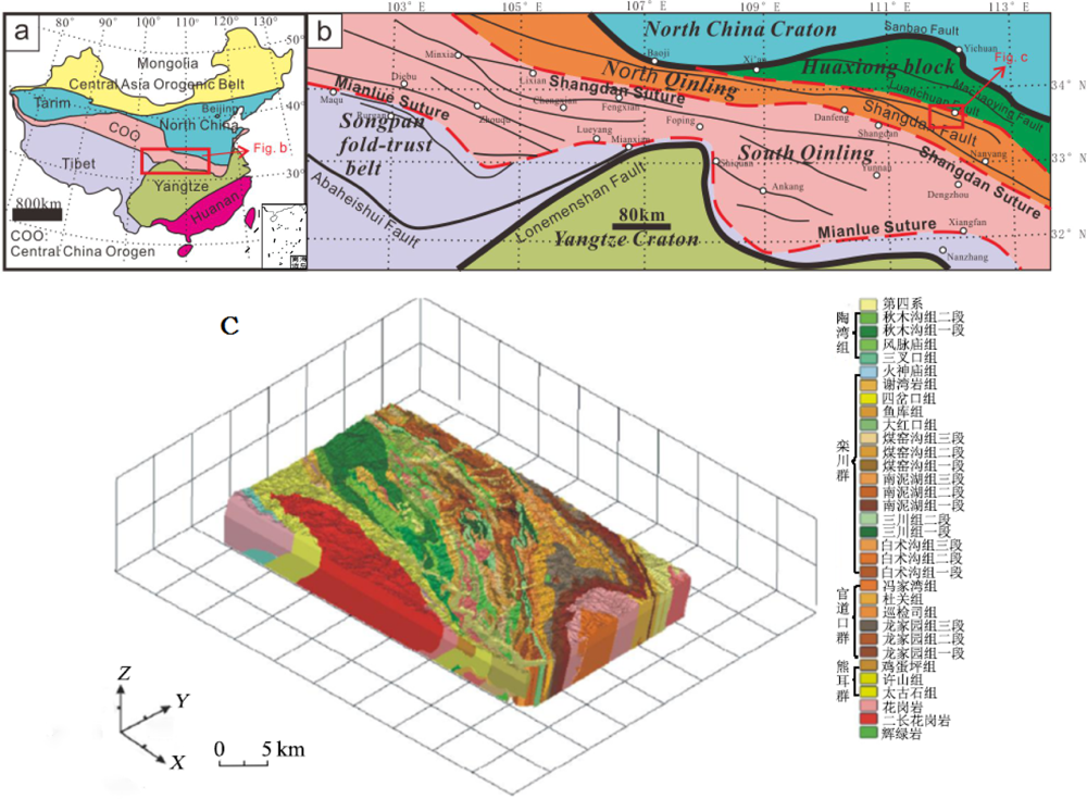
Fig.1 Simplified geological map (a), tectonic sketch map (b), and three dimensional geological model (c) of the Luanchuan mining district (500 km2 in area, 2.5 km in vertical depth)

Fig.2 Remote sensing image (ETM+342) and NW-trending structural model (2.5 km in vertical depth) of the Luanchuan mining district
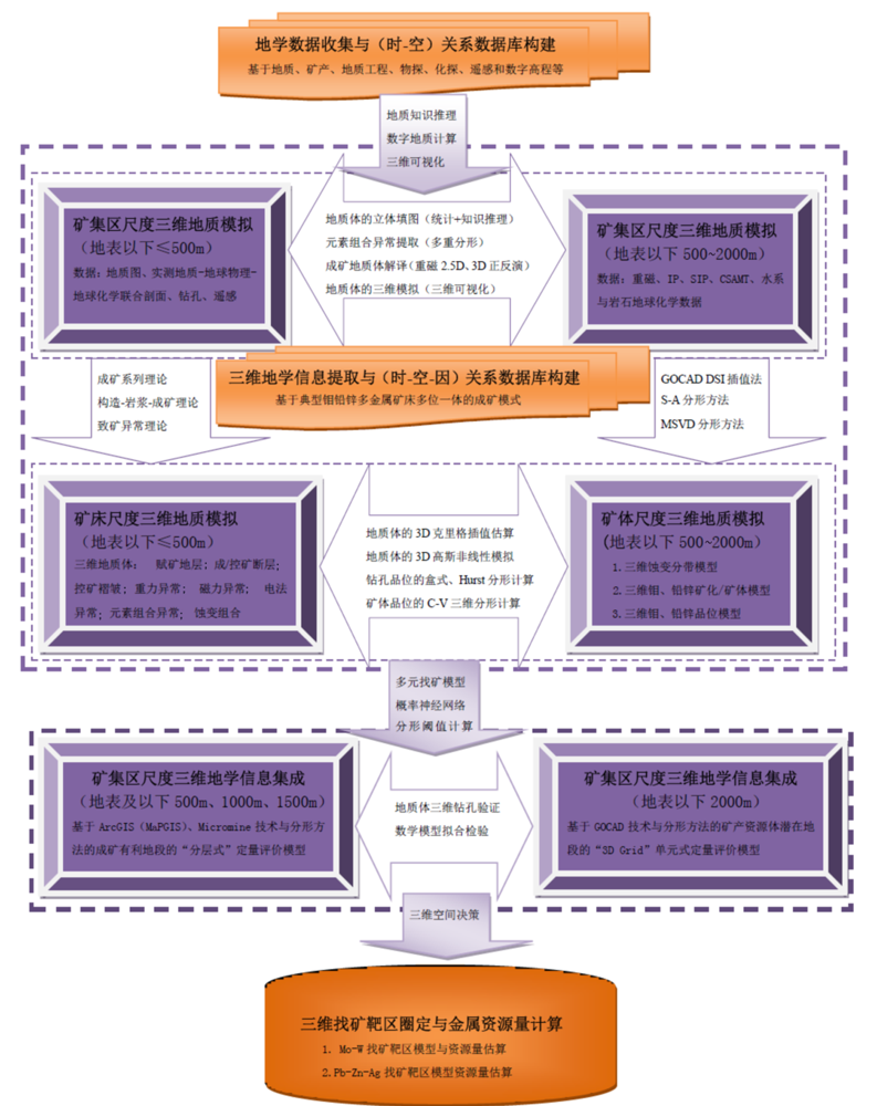
Fig.3 Flowchart of resources prediction and evaluation based on big data mining and 3D modeling for the Luanchuan mining district
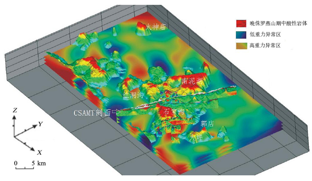
Fig.4 Cross-validation of 1:25000 gravity and magnetic interpretation of intrusive bodies from the Yanshan period as compared to CSAMT image for the Luanchuan area
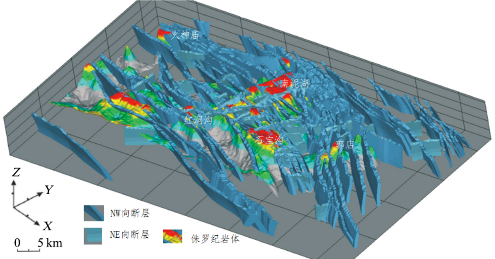
Fig.5 1:25000 gravity and magnetic interpretation of intrusive bodies from the Yanshan period and 3D structural models of the NW and NE-trending faults for the Luanchuan district

Fig.6 Interpretation of the correlation between the 3D geological model (a portion is shown) of the Luanchuan area and the MT section

Fig.7 Composite diagram showing the integrated prospecting model involving in situ geology, shallow source seismology, CSAMT, gravity-magnetic inversion, and tectono-geochemical exploration for the Luanchuan mining district. Modified after [25].

Fig.8 Dynamic simulation results of 3D intrusive rock mass in the Shibaogou mining field, Luanchuan area by Flac 3D. Adapted from [7].

Fig.9 Geometric modeling of the nappe structure of the Luanchuan mining district by experimental metallogenic dynamics analysis. Adapted from [7].

Fig.10 Worldview-2 high resolution (0.5 m) remote sensing image showing the main features of the Nannihu Mo orefield, Luanchuan area

Fig.11 Results of 3D geological, depositional and fault/intrusive body modeling of the Nannihu Mo orefield, Luanchuan area

Fig.12 Results of priority targeting of Mo and Pb-Zn mining zones of the Luanchuan area using GeoCube2.0 software
| 级别 | 地段-编号 | 靶区 | 坐标中心位置 (X,Y,Z) | 靶区概述 | 矿种 | 估算资源量(含储量) /万t |
|---|---|---|---|---|---|---|
| A | A1 | 大坪 | 553 400,3 748 700,1 040 | 大坪岩体周边为浅隐伏地段,预测地表以下100 m见矿。地表出露岩体、Mo多金属矿脉,蚀变强,断裂构造与褶皱发育,物探异常明显 估算域:斑岩-夕卡岩型Mo与热液脉型Pb-Zn矿 | Pb-Zn、Mo | Mo 30 Pb-Zn 120 |
| A2 | 碾道沟 | 549 100,3 751 300,920 | 石宝沟岩体东北部为浅隐伏地段,预测地表以下200 m见矿,有隐伏岩体(石宝沟岩体北部侧伏),NE向构造控矿显著,物探异常明显 估算域:热液脉型Pb-Zn矿 | Pb-Zn、Mo | Mo 30 Pb-Zn110 | |
| A3 | 扎子沟 | 547 500,3 750 400,1 100 | 石宝沟岩体西北部为浅隐伏地段,预测地表以下200 m见矿,有隐伏岩体(石宝沟岩体NE向侧伏),NE向构造控矿显著,物探异常明显 估算域:热液脉型Pb-Zn矿 | Pb-Zn、Mo | Mo 40 Pb-Zn 120 | |
| A4 | 大南沟 | 542 200,3 753 000,1 340 | 上房西南为隐伏矿段,预测靶区深达海拔500 m标高,有隐伏岩体,NE向构造控矿显著,物探异常明显 估算域:斑岩-夕卡岩型Mo与热液脉型Pb-Zn矿 | Pb-Zn、Mo | Mo 10 Pb-Zn 100 | |
| A5 | 冷水西 | 541 300,3 758 300,920 | 冷水西部为隐伏矿段,预测靶区深达海拔600 m标高,有隐伏岩体,NE向构造控矿显著,物探异常明显 估算域:斑岩-夕卡岩型Mo与热液脉型Pb-Zn矿 | Pb-Zn、Mo | Mo 10 Pb-Zn 100 | |
| A6 | 火神庙东 | 532 400,3 757 500,560 | 火神庙东为隐伏矿段,预测靶区深达海拔300 m标高以下,分布有隐伏中酸性岩体和基性岩体,物探异常明显 估算域:斑岩-夕卡岩型Mo与热液脉型Pb-Zn矿 | Pb-Zn、Mo | Mo 30 Pb-Zn 110 | |
| A7 | 鱼库北 | 544 900,3 749 400,860 | 东鱼库北部为浅隐伏地段,预测靶区地表以下200 m见矿,分布有隐伏中酸性岩体和基性岩体,物探异常明显 估算域:斑岩-夕卡岩型Mo与热液脉型Pb-Zn矿 | Pb-Zn、Mo | Mo 40 Pb-Zn 100 | |
| B | B1 | 黄背岭西、西北 | 540 990,3 750 800,1 250 | 黄背岭西、西北部为Pb-Zn预测找矿靶区,西北部有Mo远景区。分布有隐伏岩体,物探异常明显 估算域:斑岩型-夕卡岩型Mo矿、热液脉型Pb-Zn矿 | Pb-Zn、Mo | Mo 40 Pb-Zn 80 |
| B2 | 红洞沟东南部 | 539 800,3 747 400,1 100 | 红洞沟东南为Pb-Zn预测找矿靶区。构造控矿特征显著;陶湾群地层内分布有酸性小岩体,物探异常明显 估算域:热液脉型Pb-Zn矿 | Pb-Zn | Pb-Zn 70 | |
| B3 | 白沙洞东南 | 554 500,3 755 300,980 | 白沙洞东南为Pb-Zn预测找矿靶区。NW、NE向构造控矿特征显著;出露官道口群地层,深部可能有燕山期岩体或岩脉,物探异常明显 估算域:热液脉型Pb-Zn矿 | Pb-Zn | Pb-Zn 60 |
Table 1 Evaluation summary of main targeting areas surrounding the Mo and Pb-Zn mining zones of the Luanchuan area using GeoCube2.0 software
| 级别 | 地段-编号 | 靶区 | 坐标中心位置 (X,Y,Z) | 靶区概述 | 矿种 | 估算资源量(含储量) /万t |
|---|---|---|---|---|---|---|
| A | A1 | 大坪 | 553 400,3 748 700,1 040 | 大坪岩体周边为浅隐伏地段,预测地表以下100 m见矿。地表出露岩体、Mo多金属矿脉,蚀变强,断裂构造与褶皱发育,物探异常明显 估算域:斑岩-夕卡岩型Mo与热液脉型Pb-Zn矿 | Pb-Zn、Mo | Mo 30 Pb-Zn 120 |
| A2 | 碾道沟 | 549 100,3 751 300,920 | 石宝沟岩体东北部为浅隐伏地段,预测地表以下200 m见矿,有隐伏岩体(石宝沟岩体北部侧伏),NE向构造控矿显著,物探异常明显 估算域:热液脉型Pb-Zn矿 | Pb-Zn、Mo | Mo 30 Pb-Zn110 | |
| A3 | 扎子沟 | 547 500,3 750 400,1 100 | 石宝沟岩体西北部为浅隐伏地段,预测地表以下200 m见矿,有隐伏岩体(石宝沟岩体NE向侧伏),NE向构造控矿显著,物探异常明显 估算域:热液脉型Pb-Zn矿 | Pb-Zn、Mo | Mo 40 Pb-Zn 120 | |
| A4 | 大南沟 | 542 200,3 753 000,1 340 | 上房西南为隐伏矿段,预测靶区深达海拔500 m标高,有隐伏岩体,NE向构造控矿显著,物探异常明显 估算域:斑岩-夕卡岩型Mo与热液脉型Pb-Zn矿 | Pb-Zn、Mo | Mo 10 Pb-Zn 100 | |
| A5 | 冷水西 | 541 300,3 758 300,920 | 冷水西部为隐伏矿段,预测靶区深达海拔600 m标高,有隐伏岩体,NE向构造控矿显著,物探异常明显 估算域:斑岩-夕卡岩型Mo与热液脉型Pb-Zn矿 | Pb-Zn、Mo | Mo 10 Pb-Zn 100 | |
| A6 | 火神庙东 | 532 400,3 757 500,560 | 火神庙东为隐伏矿段,预测靶区深达海拔300 m标高以下,分布有隐伏中酸性岩体和基性岩体,物探异常明显 估算域:斑岩-夕卡岩型Mo与热液脉型Pb-Zn矿 | Pb-Zn、Mo | Mo 30 Pb-Zn 110 | |
| A7 | 鱼库北 | 544 900,3 749 400,860 | 东鱼库北部为浅隐伏地段,预测靶区地表以下200 m见矿,分布有隐伏中酸性岩体和基性岩体,物探异常明显 估算域:斑岩-夕卡岩型Mo与热液脉型Pb-Zn矿 | Pb-Zn、Mo | Mo 40 Pb-Zn 100 | |
| B | B1 | 黄背岭西、西北 | 540 990,3 750 800,1 250 | 黄背岭西、西北部为Pb-Zn预测找矿靶区,西北部有Mo远景区。分布有隐伏岩体,物探异常明显 估算域:斑岩型-夕卡岩型Mo矿、热液脉型Pb-Zn矿 | Pb-Zn、Mo | Mo 40 Pb-Zn 80 |
| B2 | 红洞沟东南部 | 539 800,3 747 400,1 100 | 红洞沟东南为Pb-Zn预测找矿靶区。构造控矿特征显著;陶湾群地层内分布有酸性小岩体,物探异常明显 估算域:热液脉型Pb-Zn矿 | Pb-Zn | Pb-Zn 70 | |
| B3 | 白沙洞东南 | 554 500,3 755 300,980 | 白沙洞东南为Pb-Zn预测找矿靶区。NW、NE向构造控矿特征显著;出露官道口群地层,深部可能有燕山期岩体或岩脉,物探异常明显 估算域:热液脉型Pb-Zn矿 | Pb-Zn | Pb-Zn 60 |

Fig.13 Digital mine 3D platform based on high resolution remote sensing and channel engineering in the Chitudian deposit in the Luanchuan district

Fig.14 Three-dimensional model of high-precision exploration drilling, orebody and channel mining engineering for the Chitudian Xigou Pb-Zn mine (location see Fig.10)
| [1] | 赵鹏大. 定量地学方法及应用[M]. 北京: 高等教育出版社, 2004. |
| [2] | 叶天竺, 吕志成, 庞振山, 等. 勘查区找矿预测理论与方法[M]. 北京: 地质出版社, 2014. |
| [3] | 薛建玲, 陈辉, 姚磊, 等. 勘查区找矿预测方法指南[M]. 北京: 地质出版社, 2018. |
| [4] | 莫宣学, 董国臣, 邓晋福, 等. 大型-超大型矿床的成矿动力学背景[M]. 北京: 地质出版社, 2020. |
| [5] | 翟裕生, 刘家军, 薛春纪, 等. 大型-超大型矿床成矿过程与机理[M]. 北京: 地质出版社, 2020. |
| [6] | 赵鹏大, 陈永清, 张寿庭, 等. 大型-超大型矿床定量评价[M]. 北京: 地质出版社, 2020. |
| [7] | 王功文, 张寿庭, 陈建平, 等. 大型-超大型矿床定量评价技术手册[M]. 北京: 地质出版社, 2019. |
| [8] | 赵鹏大. 大数据时代数字找矿与定量评价[J]. 地质通报, 2015, 34(7):1255-1259. |
| [9] | 肖克炎, 孙莉, 李楠, 等. 大数据思维下的矿产资源评价[J]. 地质通报, 2015, 34(7):1266-1272. |
| [10] | 郭华东. 地球大数据科学工程[J]. 中国科学院院刊, 2018, 33(8):818:824. |
| [11] | 周永章, 陈烁, 张旗, 等. 大数据与数学地球科学研究进展[J]. 岩石学报, 2018, 34(2):255-263. |
| [12] | 吴冲龙, 刘刚. 大数据与地质学的未来发展[J]. 地质通报, 2019, 38(7):1081-1088. |
| [13] | 赵鹏大. 地质大数据特点及其合理开发利用[J]. 地学前缘, 2019, 26(4):1-5. |
| [14] | 甘甫平, 董新丰, 闫柏琨, 等. 光谱地质遥感研究进展[J]. 南京信息工程大学学报(自然科学版), 2018, 10(1):44-62. |
| [15] | 袁峰, 张明明, 李晓晖, 等. 成矿预测:从二维到三维[J]. 岩石学报, 2019, 35(12):3863-3874. |
| [16] | BRISTOL R S, EULISS N H, BOOTH N L, et al. Science Strategy for core science systems in the U. S. Geological Survey, 2013-2023[S]. Reston, Virginia: U. S. Geological Survey, 2012. |
| [17] | BENNDORF J, BUXTON M W N, NIENHAUS K, et al. Real-time mining: moving towards continuous process management in mineral resource extraction[C]// SEYDAM S. Proceedings of the 3rd international future mining conference. Sydney. Melbourne, Victoria: The Australian Institute of Mining and Metallurgy, 2015. |
| [18] | BENNDORF J. Real-time mining: grade monitoring and control cockpit[C]// AKIDA 2016. Aachen: Institut für Maschinentechnik der Rohstoffindustrie, 2016. |
| [19] |
WAMBEKE T, BENNDORF J. A Simulation-based geostatistical approach to real-time reconciliation of the grade control model[J]. Mathematical Geosciences, 2017, 49(1):1-37.
DOI URL |
| [20] | AILLERES L, GROSE L, LAURENT G, et al. LOOP: a new open source platform for 3D geo-structural simulations[C]// BERG R C, MACCORMACK K, RUSSELL H A J, et al. Three-dimensional geological mapping: workshop extended abstracts. Illinois: Champaign, Illinois State Geological Survey, Open File Series, 2009. |
| [21] |
KREUZER O P, YOUSEFI M, NYKNEN V. Introduction to the special issue on spatial modelling and analysis of ore-forming processes in mineral exploration targeting[J]. Ore Geology Reviews, 2020, 119:103391.
DOI URL |
| [22] |
PáR W. 3D, 4D and predictive modelling of major mineral belts in Europe[M]. Berlin: Springer-Verlag, 2015: 10.1007/978-3-319-17428-0.
DOI |
| [23] | 王功文, 张寿庭, 燕长海, 等. 基于地质与重磁数据集成的栾川钼多金属矿区三维地质建模[J]. 地球科学: 中国地质大学学报, 2011, 36(2):360-366. |
| [24] | 马振波, 燕长海, 宋要武, 等. CSAMT与SIP物探组合法在河南省栾川山区隐伏金属矿勘查中的应用[J]. 地质与勘探, 2011, 47(4):654-662. |
| [25] |
WANG G W, LI R X, CARRANZA E J M, et al. 3D geological modeling for prediction of subsurface Mo targets in the Luanchuan district, China[J]. Ore Geology Reviews, 2015, 71:592-610.
DOI URL |
| [26] |
WANG G W, PANG Z S, BOISVERT J B, et al. Quantitative assessment of mineral resources by combining geostatistics and fractal methods in the Tongshan porphyry Cu deposit (China)[J]. Journal of Geochemical Exploration, 2013, 134:85-98.
DOI URL |
| [27] |
WANG G W, ZHANG S T, YAN C H, et al. Mineral potential targeting and resource assessment based on 3D geological modeling in Luanchuan region, China[J]. Computers & Geosciences, 2011, 37(12):1976-1988.
DOI URL |
| [28] |
WANG G W, ZHANG S T, YAN C H, et al. Application of the multifractal singular value decomposition for delineating geophysical anomalies associated with molybdenum occurrences in the Luanchuan ore field (China)[J]. Journal of Applied Geophysics, 2012, 86:109-119.
DOI URL |
| [29] |
ZHANG Z Q, WANG G W, MA Z B, et al. Batholith-stock scale exploration targeting based on multi-source geological and geophysical datasets in the Luanchuan Mo polymetallic district, China[J]. Ore Geology Reviews, 2019, 118:103225.
DOI URL |
| [30] |
ZHANG Z Q, WANG G W, MA Z B, et al. Interactive 3D modeling by integration of geoscience datasets for exploration targeting in Luanchuan Mo polymetallic district, China[J]. Natural Resources Research, 2017, 27(3):315-346.
DOI URL |
| [31] |
ZHANG Z Q, ZHANG J J, WANG G W, et al. From 2D to 3D modeling of mineral prospectivity using multi-source geoscience datasets, Wulong gold district, China[J]. Natural Resources Research, 2020, 29(1):345-364.
DOI URL |
| [32] |
LI R X, WANG G W, CARRANZA E J M. GeoCube: a 3D mineral resources quantitative prediction and assessment system[J]. Computers and Geosciences, 2016, 89:161-173.
DOI URL |
| [33] | AGTERBERG F P, BONHAM-CARTER G F, CHENG Q M, et al. Weights of evidence modeling and weighted logistic regression for mineral potential mapping[C]// Computers in geology: 25 years of progress. New York: Oxford University Press, 1993, 25:13-32. |
| [34] |
CHENG Q M, AGTERBERG F P, BALLANTYNE S B. The separation of geochemical anomalies from background by fractal methods[J]. Journal of Geochemical Exploration, 1994, 51(2):109-130.
DOI URL |
| [35] | TURCOTTE D L. Fractals and chaos in geology and geophysics[M]. England: Cambridge University Press, 1997. |
| [36] | PAN G, HARRIS D P. Information synthesis for mineral exploration (Vol.461)[M]. New York: Oxford University Press, 2000. |
| [37] |
AFZAL P, ALGHALANDIS Y F, KHAKZAD A, et al. Delineation of mineralization zones in porphyry Cu deposits by fractal concentration-volume modeling[J]. Journal of Geochemical Exploration, 2011, 108(3):220-232.
DOI URL |
| [38] |
CARRANZA E J M. Geocomputation of mineral exploration targets[J]. Computers & Geosciences, 2011, 37(12):1907-1916.
DOI URL |
| [39] |
CALCAGNO P, JEAN-PAUL CHILèS, COURRIOUX G, et al. Geological modelling from field data and geological knowledge: Part I. Modelling method coupling 3D potential-field interpolation and geological rules[J]. Physics of the Earth and Planetary Interiors, 2008, 171(1):147-157.
DOI URL |
| [40] |
CAUMON G, COLLON-DROUAILLET P, DE-VESLUD C L C, et al. Surface-based 3D modeling of geological structures[J]. Mathematical Geosciences, 2009, 41(8):927-945.
DOI URL |
| [41] | FALLARA F, LEGAULT M, RABEAU O. 3-D integrated geological modeling in the Abitibi Subprovince (Québec, Canada): techniques and applications[J]. Exploration & Mining Geology, 2006, 15(1/2):27-43. |
| [42] |
GRAHAM G E, KOKALY R F, KELLEY K D, et al. Application of imaging spectroscopy for mineral exploration in Alaska: a study over porphyry Cu deposits in the eastern Alaska Range[J]. Economic Geology, 2018, 113(2):489-510.
DOI URL |
| [43] | HOULDING S W. 3D geoscience modeling: computer techniques for geological characterization[M]. Berlin: Springer-Verlag, 1994. |
| [44] |
MALLET J L. Discrete smooth interpolation in geometric modelling[J]. Computer-Aided Design, 1992, 24(4):178-191.
DOI URL |
| [45] | MALLET J L. GOCAD: a computer aided design program for geological applications[M]. Berlin: Springer-Verlag, 1992. |
| [46] |
MALLET J L. Discrete modeling for natural objects[J]. Mathematical Geology, 1997, 29(2):199-219.
DOI URL |
| [47] | MALLET J L. Geomodeling. Applied geostatistics series[M]. New York: Oxford University Press, 2002. |
| [48] |
JACKSON R G. Application of 3D geochemistry to mineral exploration[J]. Geochemistry Exploration Environment Analysis, 2010, 10(2):143-156.
DOI URL |
| [49] | KAUFMANN O, MARTIN T. 3D geological modelling from boreholes, cross-sections and geological maps, application over former natural gas storages in coal mines[J]. Computers & Geosciences, 2008(34):278-290. |
| [50] |
LEITE E P, FILHO C. Probabilistic neural networks applied to mineral potential mapping for platinum group elements in the Serra Leste region, Caraja’s Mineral Province, Brazil[J]. Computers & Geosciences, 2009, 35:675-687.
DOI URL |
| [51] | LINDSAY M D, AILLÉRES L, JESSESS M W, et al. Locating and quantifying geological uncertainty in three-dimensional models: analysis of the Gippsland Basin, southeastern Australia[J]. Tectonophysics, 2012: 10-27, 546-547. |
| [52] |
POLLOCK D W, BARRON O V, DONN M J. 3D exploratory analysis of descriptive lithology records using regular expressions[J]. Computers & Geosciences, 2012, 39:111-119.
DOI URL |
| [53] |
SPRAGUE K, KEMP E, WONG W, et al. Spatial targeting using queries in a 3-D GIS environment with application to mineral exploration[J]. Computers & Geosciences, 2006, 32(3):396-418.
DOI URL |
| [54] |
ZANCHI A, FRANCESCAS S, STEFANO Z, et al. 3D reconstruction of complex geological bodies: examples from the Alps[J]. Computers & Geosciences, 2009, 35(1):49-69.
DOI URL |
| [55] | 韩江伟, 云辉, 胡红雷, 等. 河南栾川矿集区深部钨钼矿体特征及资源预测[J]. 金属矿山, 2020, 533(11):141-151. |
| [56] |
贾晗, 刘军省, 殷显阳, 等. 安徽铜陵硫铁矿集中开采区矿山地质环境评价研究[J/OL]. 地学前缘, 2021. DOI: 10.13745/j.esf.sf.2020.10.16.
DOI |
| [57] | 何亚清, 杜红波, 彭府华. 三道庄矿露天和地下岩体工程灾害监测预警应用[J]. 有色地质, 2017, 69(4):81-85. |
| [58] | 汪洁, 殷亚秋, 于航, 等. 基于RS和GIS 的浙江省矿山地质环境遥感监测[J]. 国土资源遥感, 2020, 32(1):232-236. |
| [59] | 黄蕾蕾. 内蒙古乌努格吐山矿山高精度三维地质建模与评价[D]. 北京: 中国地质大学(北京), 2020. |
| Viewed | ||||||
|
Full text |
|
|||||
|
Abstract |
|
|||||