| [1] |
BARKER C. Thermal modeling of petroleum generation: theory and applications[M]. Amsterdam: Elsevier, 1996, 45:1-512.
|
| [2] |
WELTE D H, HORSFIELD B, BARKER D R. Petroleum and basin evolution[M]. Berlin, Heidelberg: Springer, 1997: 1-535.
|
| [3] |
FORSTER A, MERRIAN D F. Geothermics in basin analysis[M]. New York: Kluwer Academic/ Plenum Publishers, 1999: 1-241.
|
| [4] |
WHITE N, THOMPSON M, BARWISE T. Understanding the thermal evolution of deep-water continental margins[J]. Nature, 2003, 426(6964):334-343.
DOI
URL
|
| [5] |
王良书, 施央申. 油气盆地地热研究[M]. 南京: 南京大学出版社, 1989: 1-127.
|
| [6] |
邱楠生, 胡圣标, 何丽娟. 沉积盆地热体制研究的理论与应用[M]. 北京: 石油工业出版社, 2004: 1-240.
|
| [7] |
汪集旸, 胡圣标, 庞忠和, 等. 地热学及其应用[M]. 北京: 科学出版社, 2015.
|
| [8] |
RENNER J L. The future of geothermal energy: impact of enhanced geothermal systems (EGS) on the United States in the 21st Century[M]. Boston: MIT, 2006:1-372.
|
| [9] |
HUENGES E, PATRICK L. Geothermal energy systems: exploration, development, and utilization[M]. Hoboken: John Wiley & Sons, 2011: 1-486.
|
| [10] |
STOBER I, BUCHER K. Geothermal energy: from theoretical modeling to exploration and development[M]. Berlin: Springer, 2013: 1-291.
|
| [11] |
王钧, 黄尚瑶, 黄歌山, 等. 中国南部地温分布的基本特征[J]. 地质学报, 1986, 60(3):297-310.
|
| [12] |
袁玉松, 马永生, 胡圣标, 等. 中国南方现今地热特征[J]. 地球物理学报, 2006, 49(4):1118-1126.
|
| [13] |
徐明, 朱传庆, 田云涛, 等. 四川盆地钻孔温度测量及现今地热特征[J]. 地球物理学报, 2011, 54(4):1052-1060.
|
| [14] |
卢庆治, 胡圣标, 郭彤楼, 等. 川东北地区异常高压形成的地温场背景[J]. 地球物理学报, 2005, 48(5):1110-1116.
|
| [15] |
李宗星, 赵平, 孙占学, 等. 江汉盆地南部热史与下志留统海相烃源岩成熟度演化研究[J]. 地球物理学报, 2010, 53(12):2918-2928.
|
| [16] |
王良书, 李成, 施央申, 等. 下扬子区地温场和大地热流密度分布[J]. 地球物理学报, 1995, 38(4):469-476.
|
| [17] |
王华玉, 刘绍文, 雷晓. 华南下扬子区现今地温场特征[J]. 煤炭学报, 2013, 38(5):896-900.
|
| [18] |
李献华, 李武显, 何斌. 华南陆块的形成与Rodinia超大陆聚合-裂解:观察、解释与检验[J]. 矿物岩石地球化学通报, 2012, 31(6):543-559.
|
| [19] |
黄保家, 施荣富, 赵幸滨, 等. 下扬子皖南地区古生界页岩气形成条件及勘探潜力评价[J]. 煤炭学报, 2013, 38(5):877-882.
|
| [20] |
潘继平, 乔德武, 李世臻, 等. 下扬子地区古生界页岩气地质条件与勘探前景[J]. 地质通报, 2011, 31(2):337-343.
|
| [21] |
梁兴, 叶舟, 马力, 等. 中国南方海相含油气保存单元的层次划分与综合评价[J]. 海相油气地质, 2004, 30(2):59-76.
|
| [22] |
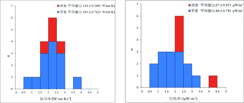
李香兰, 刘绍文, 徐明, 等. 华南下扬子区泥页岩热物性测试与分析[J]. 天然气地球科学, 2015, 26(8):1525-1533.
|
| [23] |
NOACK V, CHERUBINI Y, SCHECK-WENDEROTH M, et al. Assessment of the present-day thermal fields (NE German Basin)-inferences from 3D modeling[J]. Chemie der Erde, 2010, 70:47-62.
DOI
URL
|
| [24] |
BANKS J, HARRIS N B. Geothermal potential of foreland basins: a case study from the Western Canadian sedimentary basin[J]. Geothermics, 2018, 76:74-92.
DOI
URL
|
| [25] |
周宁, 李贞子, 贾仲宣. 地温梯度的统计回归分析[J]. 钻采工艺, 1997, 20(5):5-9.
|
| [26] |
CHAPMAN D S. Thermal gradients in the lower continental crust[M]//DAWSON J B, CARSWELL D A, HALL J, et al. The nature of the lower continental crust. Carswell: Geological Society Special Publication, 1986, 24:63-70
|
| [27] |
刘晓燕, 赵军, 石成, 等. 土壤恒温层温度及深度研究[J]. 太阳能学报, 2007, 28(5):494-498.
|
| [28] |
SELLEY R C. Elements of petroleum geology[M]. 2nd ed. Oxford: Elsevier, 1998.
|
| [29] |
ROBELIUS F. Giant oil fields: the highway to oil: giant oil fields and their importance for future oil production[D]. Uppsala: Uppsala University, 2007.
|
| [30] |
BULLER A T, BJØRKUM P A, NADEAU P H, et al. Distribution of hydrocarbons in sedimentary basins[J]. Research & Technology Memoir, 2005, 7:1-15.
|
| [31] |
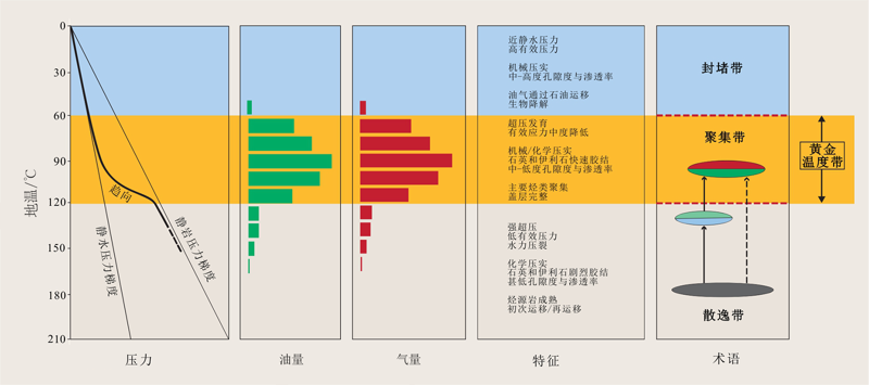
NADEAU P H. Earth’s energy ‘golden zone’: a synjournal from mineralogical research[J]. Clay Minerals, 2011, 46(1):1-24.
DOI
URL
|
 ), LIU Shaowen1,2,*(