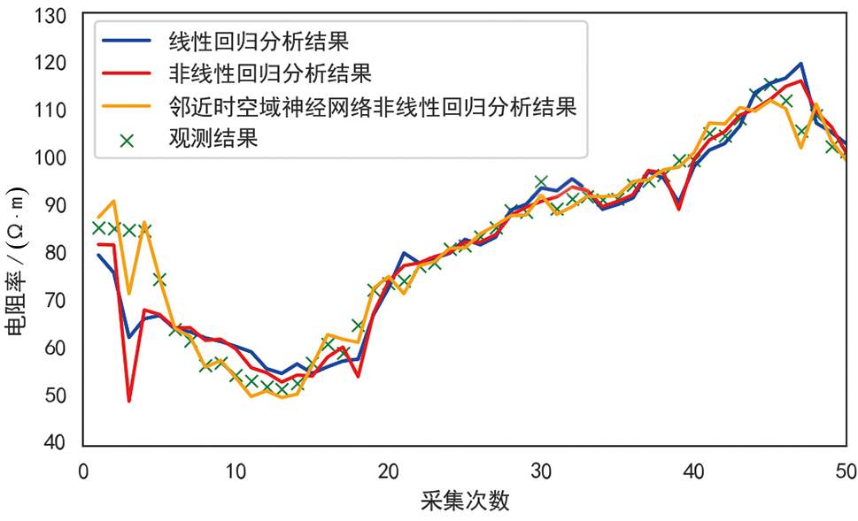
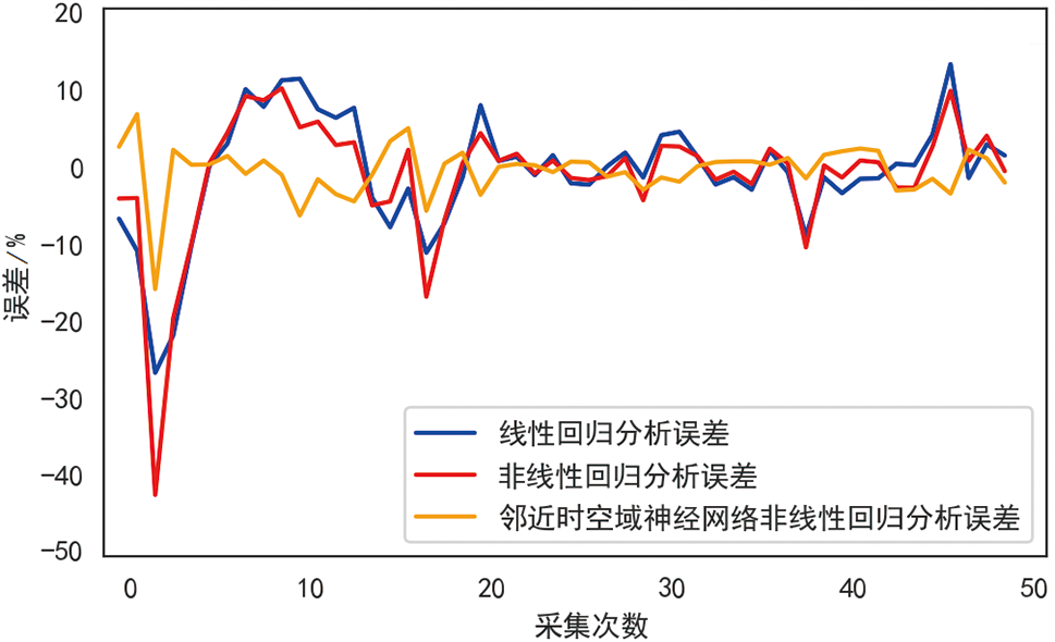
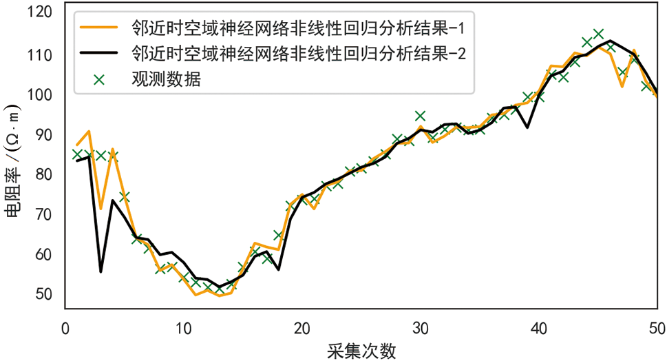
| [1] |
贺可强, 周敦云, 王思敬. 降雨型堆积层滑坡的加卸载响应比特征及其预测作用与意义[J]. 岩石力学与工程学报, 2004, 23(16): 2665-2670.
|
| [2] |
钟源, 李远耀, 殷坤龙, 等. 基于物理模型试验的厚层堆积层滑坡强降雨触发机制[J/OL]. 地球科学: 1-14[2022-02-14]. https://kns-cnki-net.webvpn.ecut.edu.cn/kcms/detail/42.1874.P.20220113.1040.002.html.
|
| [3] |
李高, 谭建民, 王世梅, 等. 滑坡对降雨响应的多指标监测及综合预警探析: 以赣南罗坳滑坡为例[J]. 地学前缘, 2021, 28(6): 283-294.
DOI
|
| [4] |
赵超英, 刘晓杰, 张勤, 等. 甘肃黑方台黄土滑坡InSAR识别、 监测与失稳模式研究[J]. 武汉大学学报(信息科学版), 2019, 44(7): 996-1007.
|
| [5] |
FERMIN V, JOSE T, JOSE A R, et al. New framework based on fusion information from multiple landslide data sources and 3D visualization[J]. Journal of Earth Science, 2020, 31(1): 159-170.
DOI
|
| [6] |
张明, 胡瑞林, 殷跃平, 等. 川东缓倾红层中降雨诱发型滑坡机制研究[J]. 岩石力学与工程学报, 2014, 33 (增刊2): 3783-3790.
|
| [7] |
LAPENNA V, LORENZO P, PERRONE A, et al. 2D Electrical resistivity imaging of some complex landslides in Lucanian Apennine Chain, southern Italy[J]. Geophysics, 2005, 70(1): 11-18.
|
| [8] |
孙永帅, 胡瑞林. 不同角度基覆面上土石混合体变形试验研究及对滑坡演化的启示[J]. 地学前缘, 2023, 30(3): 494-504.
DOI
|
| [9] |
陈善雄, 许锡昌, 徐海滨. 降雨型堆积层滑坡特征及稳定性分析[J]. 岩土力学, 2005, 26(增刊2): 6-10.
|
| [10] |
郭璐, 贺可强, 贾玉跃. 水库型堆积层滑坡位移方向协调性参数及其失稳判据研究[J]. 水利学报, 2018, 49(12): 1532-1540.
|
| [11] |
何少其, 刘元雪, 杨骏堂, 等. 库岸堆积层滑坡位移的分量响应模式及多因子模型[J]. 岩土力学, 2020, 41(8): 2773-2784.
|
| [12] |
杨天春, 陈卓超, 梁竞, 等. 天然电场选频测深法在地下水勘探中的异常理论分析与实践应用[J]. 地学前缘, 2020, 27(4): 302-310.
DOI
|
| [13] |
闫亚景, 闫永帅, 赵贵章, 等. 基于高密度电法的天然边坡水分运移规律研究[J]. 岩土力学, 2019, 40(7): 2807-2814.
|
| [14] |
SUNARYO A S, ALAMSYAH M, YUWONO, et al. Slope stability analysis for landslides natural disaster mitigation by means of geoelectrical resistivity data in Gedangan of South Malang[J]. Materials Science and Engineering, 2019, 546(2): 334-346.
|
| [15] |
AKMANM H, AMIR A, PUTRA, et al. Implementation of least-square constrain inversion method of geoelectrical resistivity data Wenner-Schlumberger for investigation the characteristic of landslide[J]. Indian Journal of Public Health Research & Development, 2019, 10(8): 2456-2469.
|
| [16] |
GURUH S, MUHAMMAD F R, JUNUN S, et al. Characterization of displacement and internal structure of landslides from multitemporal UAV and ERT imaging[J]. Landslides, 2020, 17(10): 2455-2468.
DOI
|
| [17] |
罗鸿东, 李瑞冬, 张勃, 等. 基于信息量法的地质灾害气象风险预警模型: 以甘肃省陇南地区为例[J]. 地学前缘, 2019, 26(6): 289-297.
DOI
|
| [18] |
ZHANG L, SHI B, ZHU H, et al. PSO-SVM-based deep displacement prediction of Majiagou landslide considering the deformation hysteresis effect[J]. Landslides, 2021, 18(1): 179-193.
DOI
|
| [19] |
CAITLIN J. TRAN, OMAR E, et al. Unsupervised classification for landslide detection from airborne laser scanning[J]. Geosciences, 2019, 9(5): 113-124.
DOI
URL
|
| [20] |
MEENA S R, GHORBANZADEH O, WESTEN C, et al. Rapid mapping of landslides in the Western Ghats (India) triggered by 2018 extreme monsoon rainfall using a deep learning approach[J]. Landslides, 2021, 18(5): 1937-1950.
DOI
|
| [21] |
谢顺平, 叶罕霖. 面向空间关系复合的矢量多边形图形拓扑叠置分析算法[J]. 计算机辅助设计与图形学学报, 2018, 30(9): 1678-1685.
|
| [22] |
王中一. 顾及全域时空复杂邻近性的神经网络加权回归方法[D]. 杭州: 浙江大学, 2020.
|
| [23] |
WU B, LI R, HUANG B. A geographically and temporally weighted auto regressive model with application to housing prices[J]. International Journal of Geographical Information Science, 2014, 28(5): 1186-1204.
DOI
URL
|
| [24] |
许泽坤, 陈隽. 非线性结构地震响应的神经网络算法[J]. 工程力学, 2021, 38(9): 133-145.
|
| [25] |
艾骁. 基于机器学习的地震滑坡易发性评估模型构建[D]. 哈尔滨: 中国地震局工程力学研究所, 2021.
|
 ), DENG Juzhi1, XIAO Hui2,3,*(